DAS Bump!
My summary of this morning’s session: “Forecasting Earthquakes with Continuous Data: From Lab to Field”. Sounds like a SCEC German punk band. #scecmeet
08.09.2025 16:24 — 👍 1 🔁 0 💬 0 📌 0

Tom Rockwell standing on the stage in front of 4 chairs. On the left is a large projection screen showing one of his slides that includes a photomicrograph of fractured mineral grains.

A slide from Tom’s talk showing an annotated aerial view of the San Andreas Fault near Little Rock and a photomicrograph on the right showing pulverized mineral grains from a sample collected several meters from the main fault plane.

Summary slide of Tom’s talk labeled: General Summary of Physical Damage. Includes three categories: small displacement (less than 1 meter), moderate (1.5 to 2.7 meter), and large displacement (3 to 6 meters).
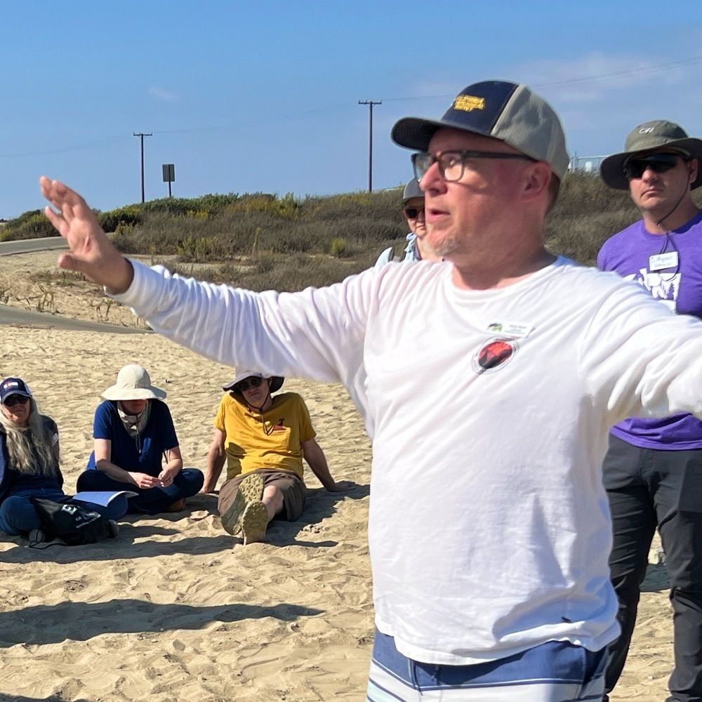
Tom Rockwell (Distinguished Lecture) kicking off the 2025 SCEC meeting! Small offset per event (smaller magnitude) produces narrower damage zone in nearby rocks. Serves as a proxy for max magnitude per rupture event. #scecmeet #scec2025 🧪
08.09.2025 01:38 — 👍 7 🔁 1 💬 0 📌 0

Digital image off the USS Enterprise from the Star Trek franchise. Small pictures of the science researchers are in little circles around the edge. The bottom of the slide says: “To boldly go where no SCEC has gone before.”
Opening presentation of this year’s SCEC annual meeting in Palm Springs! It seems SCEC is a “large Enterprise” working to develop & share cutting-edge earthquake system science to enhance California’s resilience & to educate and inspire future scientists. #scecmeet #SCEC2025 🧪
08.09.2025 00:48 — 👍 4 🔁 0 💬 0 📌 0
Well, given that he's not running for governor again becuase he reached his term limit....
10.06.2025 16:45 — 👍 5 🔁 1 💬 0 📌 0
Ha!! Next time I’ll include a random non-sequitur limerick somewhere in my draft and it’ll be your job to find and remove it. 😆
11.05.2025 04:54 — 👍 3 🔁 0 💬 2 📌 0
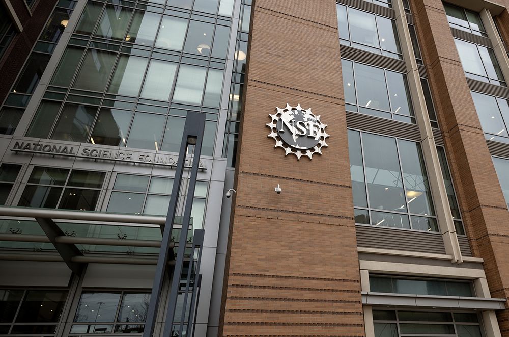
Exclusive: NSF faces radical shake-up as officials abolish its 37 divisions
Changes seen as a response to presidential directives on what research to fund
“NSF watchers fear that a smaller, restructured agency could be more vulnerable to pressure from the White House to fund research that suits its ideological bent.” www.science.org/content/arti...
09.05.2025 11:58 — 👍 1197 🔁 438 💬 45 📌 25
Did they work the graveyard shift and were heading home?
08.05.2025 23:41 — 👍 3 🔁 0 💬 1 📌 0
I'm guessing there was a real reason that the new pope served as the bishop of Chiclayo, but I'm going to pretend that whoever was doing the bishop assignments misheard it as Chicago and was like "great we can just promote one of our Chicago guys".
08.05.2025 19:06 — 👍 9 🔁 2 💬 0 📌 0
There are new ducklings ALL over Disneyland these days. They had to stop the parade the other day to let them cross the street.
08.05.2025 20:12 — 👍 2 🔁 0 💬 0 📌 0
Hey-OOOOOO!!!
08.05.2025 20:11 — 👍 2 🔁 0 💬 0 📌 0
"They picked a globalist pope!" - Yes, he's the leader of the GLOBAL Catholic Church. Duh!
08.05.2025 19:50 — 👍 13 🔁 0 💬 0 📌 0
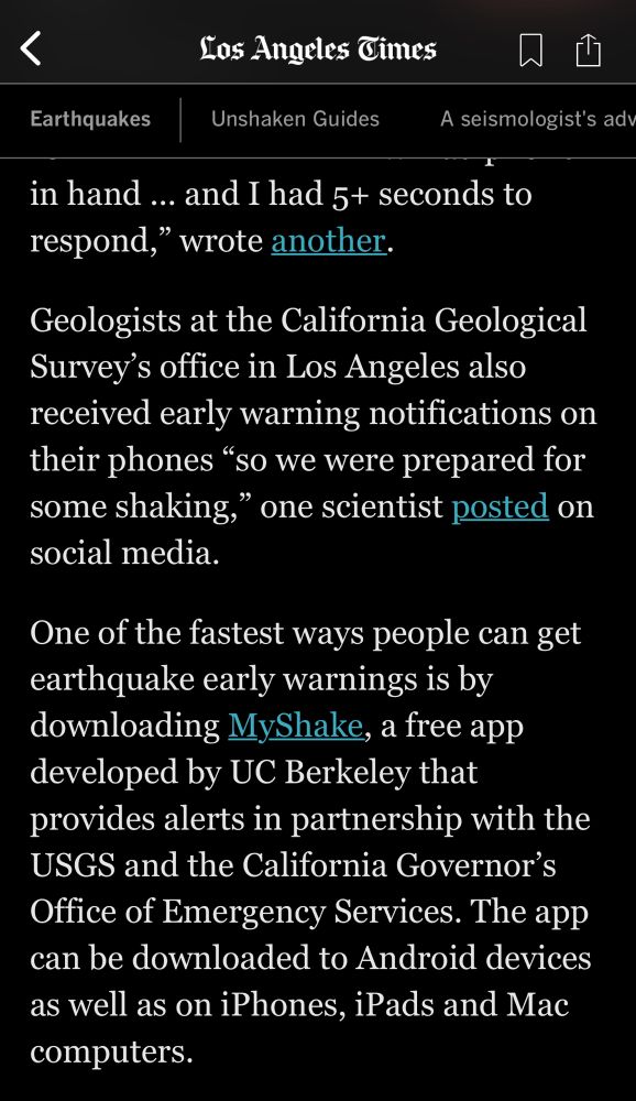
Screen shot of an online article from the Los Angeles Times about this week’s magnitude 5.2 earthquake and the early warning notifications. The text says, “Geologists at the California Geological Survey’s office in Los Angeles also received early warning notifications on their phones ‘so we were prepared for some shaking,’ one scientist posted on social media.”
It’s me! I’m “one scientist”! 🧪
17.04.2025 00:56 — 👍 2 🔁 0 💬 0 📌 0
Gulf of Mexico in my heart.
14.04.2025 18:25 — 👍 5 🔁 0 💬 0 📌 0
Not on my end. Lame.
14.04.2025 18:02 — 👍 1 🔁 0 💬 1 📌 0
That's not unusual when you are that close to the epicenter. At some point you are close enough that the seismic waves are faster than the computers can calculate and send the warning message.
14.04.2025 17:53 — 👍 1 🔁 0 💬 1 📌 0
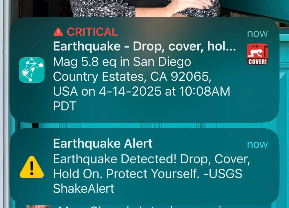
Screenshot of MyShake notifications for a magnitude 5.8 earthquake (later revised to 5.2) in San Diego County. The alert reads: “Earthquake - Drop, cover, hold on. Mag 5.8 EQ in San Diego Country Estates, CA 92065, USA on 4-14-2025 at 10:08am PDT”.
A second alert under the first says: “Earthquake Alert
Earthquake Detected! Drop, Cover, Hold On. Protect yourself. - USGSShakeAlert.”
Us geologists here at the @cageosurvey.bsky.social LA office all got our early warning notifications on our phones so we were prepared for some shaking. Did you get one too?
Download @myshakeapp.bsky.social to be ready next time. #earthquake
14.04.2025 17:37 — 👍 2 🔁 0 💬 1 📌 0
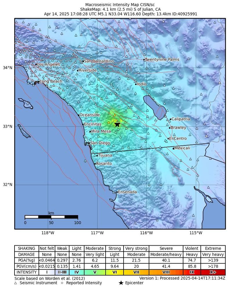
This ShakeMap shows the ground shaking intensity from a magnitude 5.2 earthquake that occurred on April 14, 2025. The epicenter is marked with a black star and located just south of Julian, California, in San Diego County.
The shaking intensity is represented using the Modified Mercalli Intensity (MMI) scale, with colors ranging from green (light shaking) near the epicenter to blue (weak shaking) farther out. The strongest shaking (MMI V to VI) was felt in the mountains and foothill regions northeast of San Diego, including areas near Mira Mesa and Encinitas.
Seismic instrument locations are shown as triangles, and community-reported intensities are marked with small circles. Cities across Southern California and northern Baja California, including San Diego, Oceanside, Riverside, and Tijuana, experienced weak to light shaking. The scale at the bottom links MMI levels to estimated damage and ground motion levels, helping to interpret the impact across the region.
Felt the long-period shaking here in downtown LA from the M5.2 earthquake near Julian, CA (San Diego County). Epicenter is near the Elsinore Fault, which would be the primary suspect, but we'll see once more data comes in. #earthquake #Julian 🧪 @cageosurvey.bsky.social
14.04.2025 17:26 — 👍 2 🔁 1 💬 0 📌 0
You’ll forgive my concerns over a possible upcoming recession. I lost my job and almost lost my house in the last one.
07.04.2025 18:11 — 👍 2 🔁 0 💬 0 📌 0
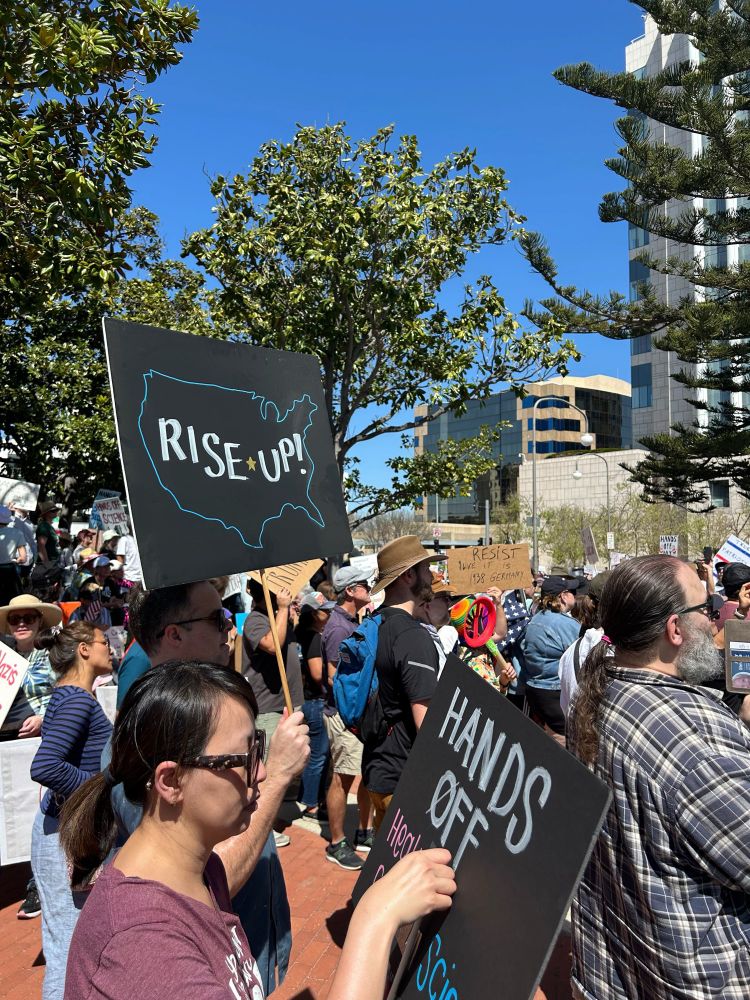
A crowd of protesters at a rally. One of them is holding up a black sign with an outline of the United States with the words “Rise Up!” written inside.
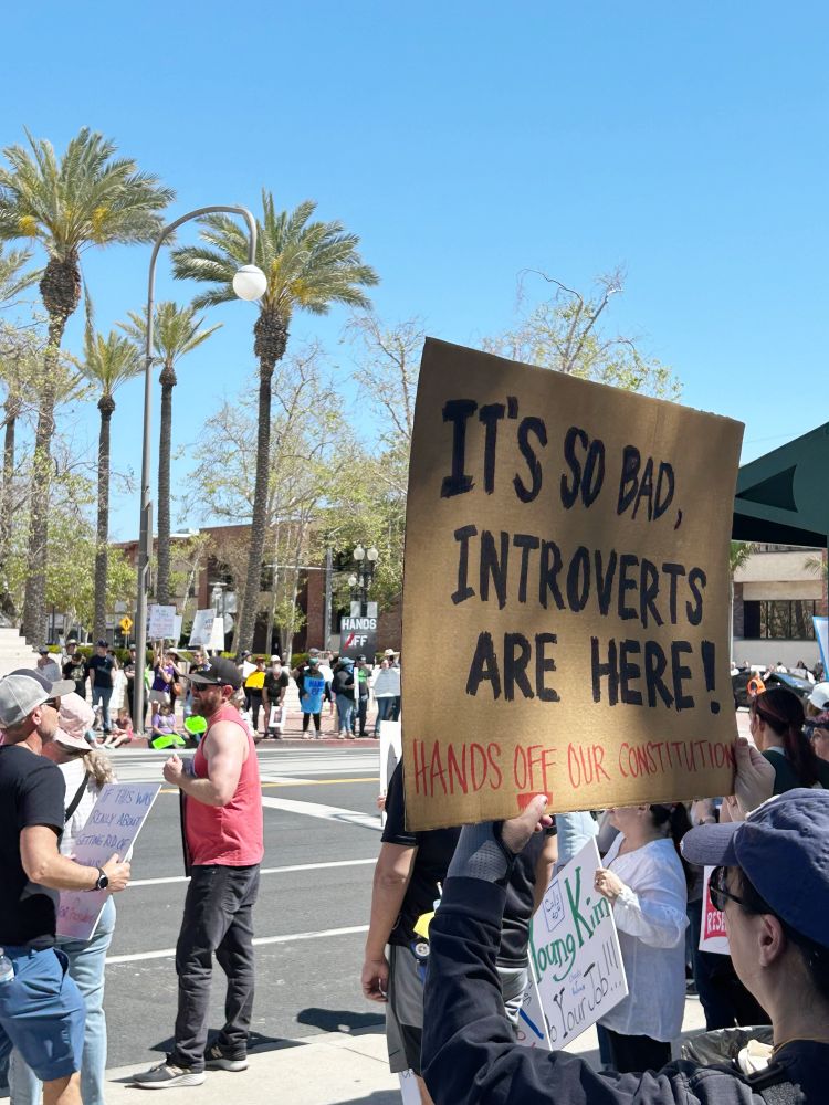
A group of protestors on the sidewalk. One is holding a cardboard sign that reads “It’s so bad, introverts are here! Hands off our Constitution.”
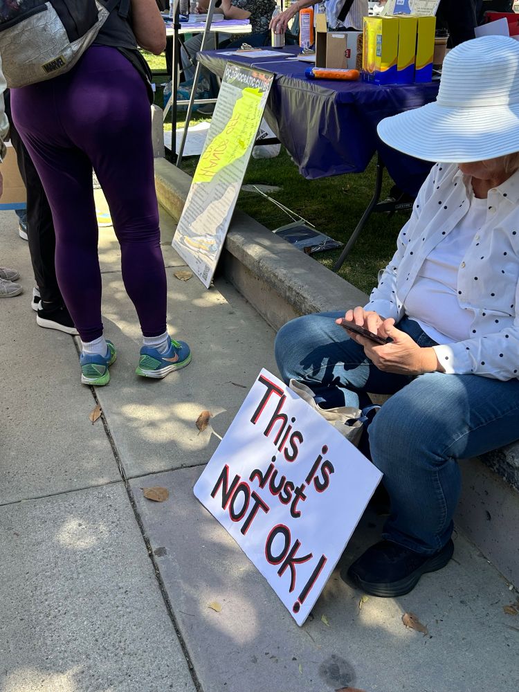
A woman sitting on the curb with a white sign that reads “Thisis just not OK!”
So encouraged by everyone we saw at the Hands Off rally yesterday in Santa Ana (Orange County)! #HandsOff
Rise Up. Wise Up. Eyes Up.
06.04.2025 18:26 — 👍 5 🔁 0 💬 0 📌 0
What do the Republicans and the oligarchs fear most? Solidarity between poor rural whites and Black urban folks.
They have always feared it. It’s time to come together, friends. Our futures are bound up together.
05.04.2025 22:48 — 👍 2136 🔁 497 💬 65 📌 26

Two t-shirts, a blue one reading “ano more Kings” with a cartoon drawing of King George III sitting on a stool with bags of money from Schoolhouse Rock. The second is a white shirt with multicolored balloons on top the word “No”.
Heading out to our local Orange County Hands Off rally shortly. #handsoff
05.04.2025 19:34 — 👍 5 🔁 0 💬 0 📌 0
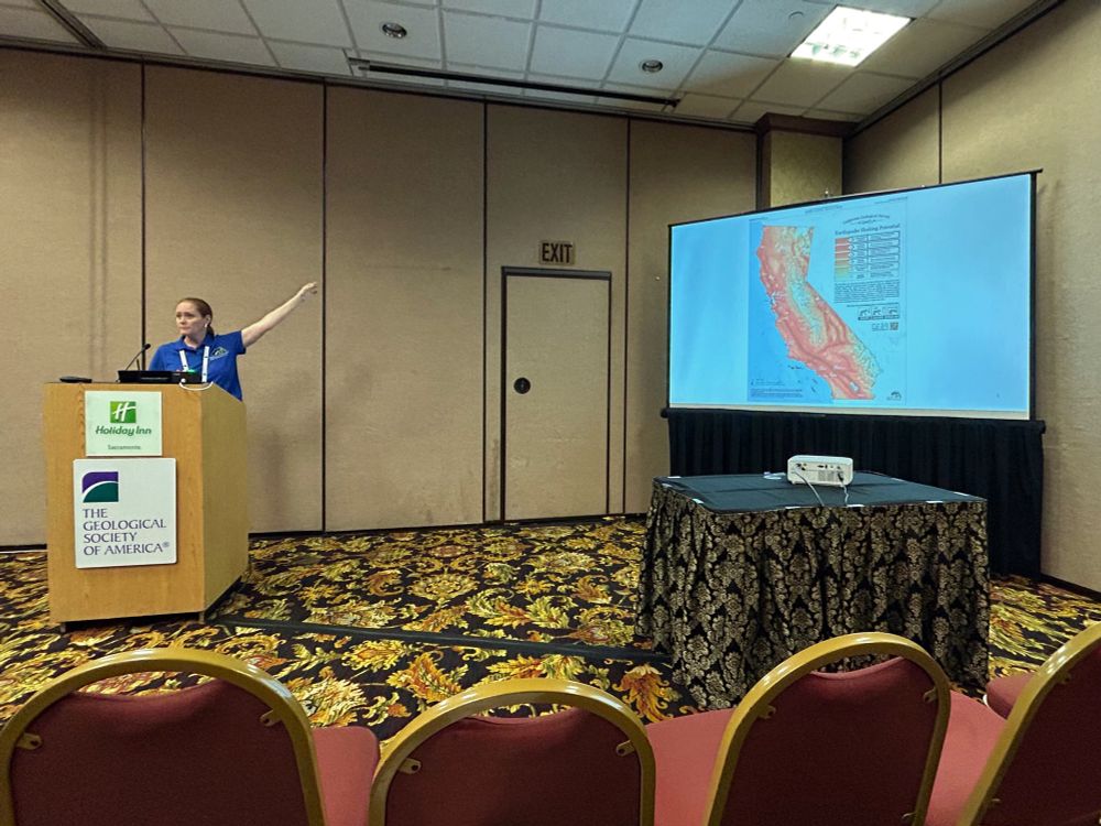
Photo of Wendy Bohon giving a presentation at the Geological Society of America, Cordilleran Section meeting in Sacramento. She is in a hotel conference room standing behind a wooden lectern with her arm lifted and extended towards the projection screen. On the screen is a map of California showing the largest potential earthquake shaking intensities for each area of the state.
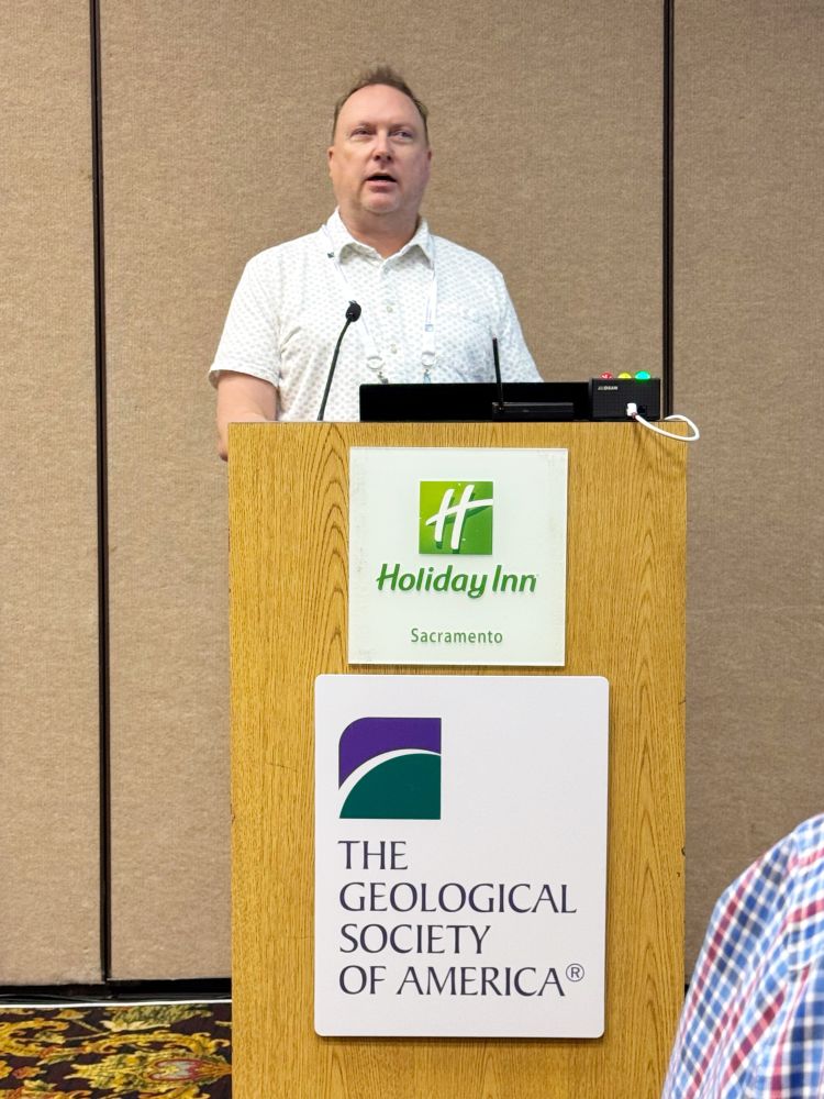
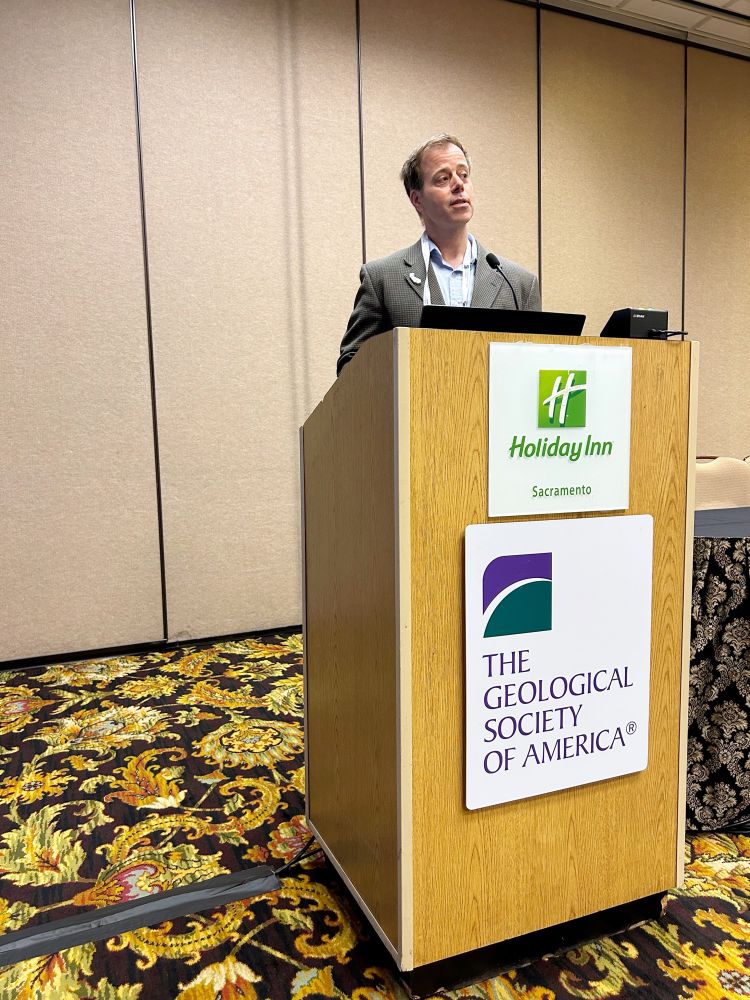
Photo of Brian Olson giving a presentation at the Geological Society of America, Cordilleran Section meeting in Sacramento. He is in a hotel conference room standing behind a wooden lectern addressing the audience. A sign at the top front of the lectern reads “Holiday Inn Sacramento” and another sign at the bottom reads “The Geological Society of America”.
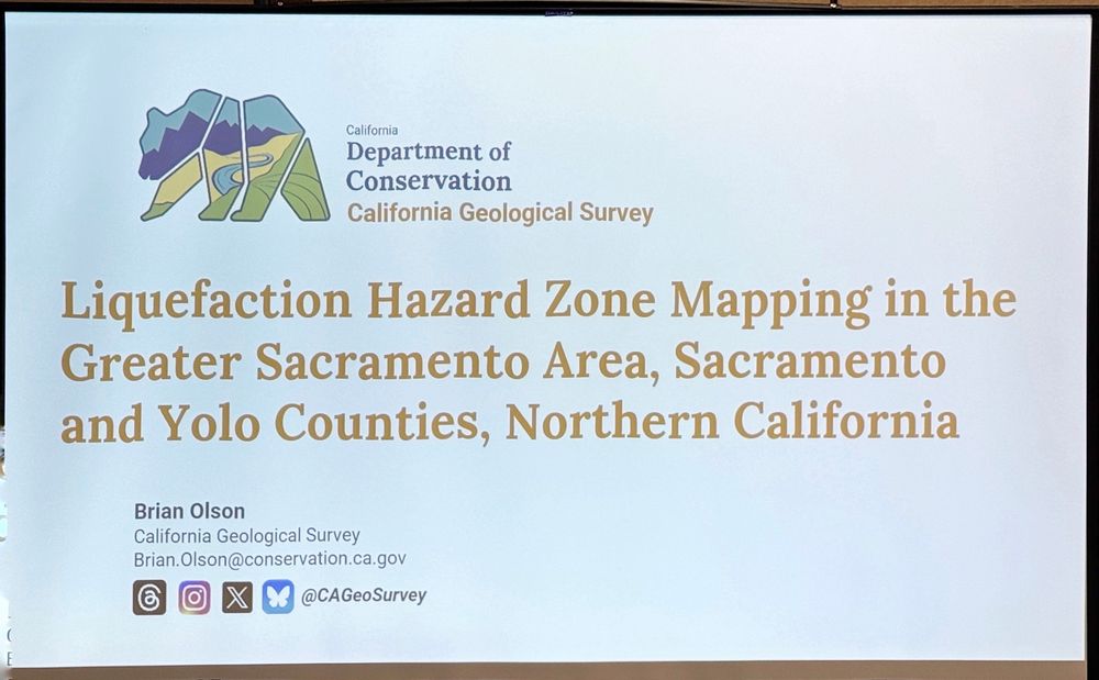
Title slide of Brian Olson’s presentation that reads “Liquefaction Hazard Zone Mapping in the Greater Sacramento Area, Sacramento and Yolo Counties, Northern California.” At the top left is a multi-colored version of the California gear from the state flag with text to the right that reads “California Department of Conservation, California Geological Survey”. In the lower left is Brian’s name, job title (Senior Engineering Geologist), and CGS’ social media handle of “@CAGeoSurvey”.
Talks went very well and a great time was had by all!
05.04.2025 01:57 — 👍 7 🔁 0 💬 0 📌 0
Sand worms?
05.04.2025 00:05 — 👍 1 🔁 0 💬 0 📌 0
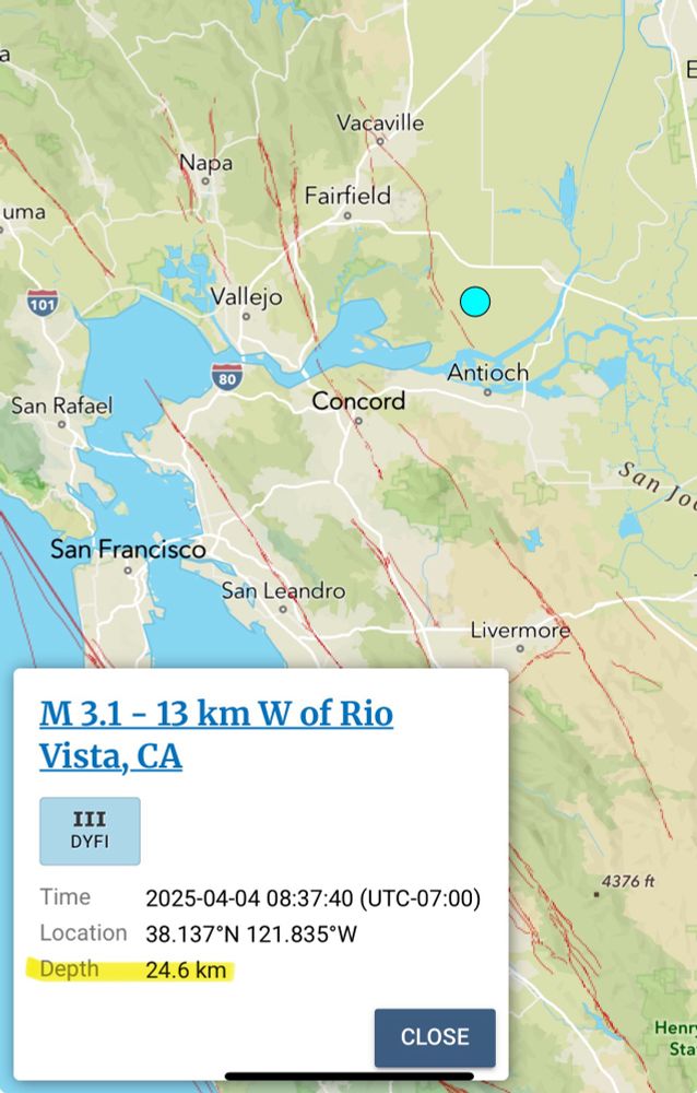
Map of the San Francisco Bay and Sacramento River delta and surrounding areas. A white circle is shown north of the city of Antioch representing the epicenter of a magnitude 3.1 earthquake. A white box with details about the quake is shown in the lower left corner. It states this earthquake was 13 kilometers west of Rio Vista, CA occurring at 8:37am on April 4. The hypocenter is listed at 24.6 kilometers and is highlighted in yellow for emphasis.
Anyone have any insight into why this M3.1 in the Sacramento delta is SO deep? 🧪
04.04.2025 17:59 — 👍 1 🔁 0 💬 1 📌 0
The context is “0.5 inch(es) of settlement is expected.”
04.04.2025 05:50 — 👍 0 🔁 0 💬 0 📌 0
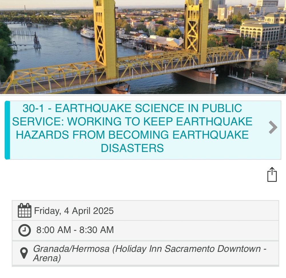
Screenshot of the talk title, which says “earthquake science and public service: working to keep earthquake hazards from becoming earthquake disasters“. Friday, April 4, 2025 8 AM to 8:30 AM in the Granada Hermosa.
Folks attending the @geosociety.bsky.social Cordilleran conference - roll out of bed early, grab a ☕️ and head over to the Granada Room to catch my 8:00 am talk! Then stick around to learn about liquefaction hazards in Sacramento from @brianolson.bsky.social at 9:10. 😎
04.04.2025 03:02 — 👍 29 🔁 4 💬 0 📌 0
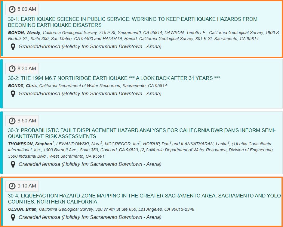
Screen shot of the Friday morning schedule of speakers with orange boxes highlighting a talk by Wendy Bohon entitled "Earthquake Science in Public Service: Working to Keep Earthquake Hazards from becoming Earthquake Disasters" at 8:00am and a talk by Brian Olson entitled " Liquefaction Hazard Zone Mapping in the Greater Sacramento Area, Sacramento and Yolo Counties, northern California" at 9:10am.
If you're at the GSA Cordilleran Section meeting in Sacramento tomorrow, stop by the "Earthquake Hazards in Applied Geology" session tomorrow morning and catch me and Wendy Bohon in action as we represent the California Geological Survey! 🧪 @drwendyrocks.bsky.social @cageosurvey.bsky.social
04.04.2025 04:45 — 👍 19 🔁 3 💬 1 📌 0
Help me... I'm reviewing a technical document and need to know... is it "0.5 inch" or "0.5 inches"? 🧪
Can't find any style guides or clear rules.
04.04.2025 04:33 — 👍 2 🔁 0 💬 5 📌 0
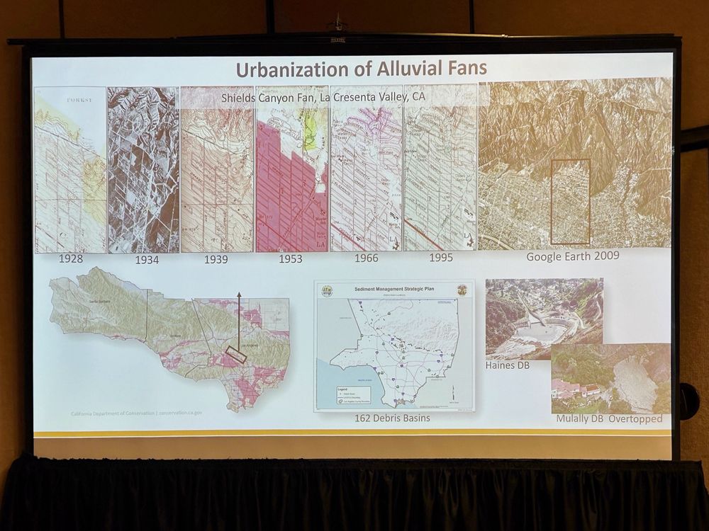
PowerPoint slide showing different topographic maps of one area of La Cañada showing more homes being built over time from 1928 to 2009. In 1928 the area is very lightly populated with scattered homes and by 2009 every lot is filled with homes and other buildings.
Example from La Cañada showing progressive residential development on an alluvial fan that has seen numerous debris flow flooding. Risk is changing with a warming climate, hazard is increasing with expanding construction. 🧪 #CDGSA2025 @cageosurvey.bsky.social
02.04.2025 18:55 — 👍 1 🔁 0 💬 0 📌 0
California state geologist Jeremy Lancaster stands behind a podium speaking into the microphone giving a presentation.
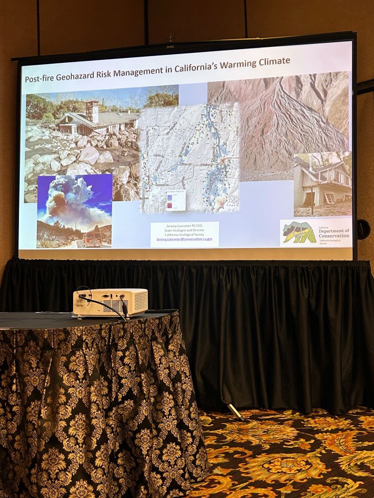
Title slide of Jeremy Lancaster’s talk reading “Post-Fire geohazard management in California’s warming climate”.
Jeremy Lancaster (California State Geologist) giving the lunchtime lecture at GSA on post-wildfire flooding & debris flow hazards. Highly developed alluvial fans are most prone. Studies find a minimum flow depth of 5 feet equaled total destruction of structures. @cageosurvey.bsky.social
02.04.2025 18:35 — 👍 4 🔁 1 💬 1 📌 0
Modern Landscape Painter
JimMusil.com
Real-time updates on the latest filings in cases challenging Trump administration executive actions. Sponsored by @lawfare.bsky.social
Curated by @annahickey.bsky.social and @tylermcbrien.bsky.social
https://bots.law/little-cases/trump-litigation-bot
Senior counsel at the Brennan Center w/ a focus on using state constitutions to protect rights. Managing editor of State Court Report. In a past life I was an appellate attorney combating cruel & inhumane prison conditions.
Talking Points Memo (TPM) is an independent news organization that publishes reporting and analysis about American politics, public policy and political culture. https://talkingpointsmemo.com/
We’re organizing against this fascistic clown show of a regime the only way that actually works — with on-the-ground, volunteer-led, communities of people power: https://linktr.ee/indivisibleteam
It is said that there may be seeming disorder and yet no real disorder at all
Amanda Katz said this was the cool kids table.
Jon Blackwell, an editor @wsj. Reporting events from a century ago. Also see my companion account @250yearsagonews.bsky.social
PhD in Geosciences specializing in dendrochronology, freshwater resources, and geochronology. Posts my own.
Leading digital news and information platform covering voting rights, elections, and the courts — from an unapologetically pro-democracy standpoint.
Newsletters: https://bit.ly/4iz4QBg
Reporting: democracydocket.com
Founded: @marcelias.bsky.social
Internet Archive is a non-profit research library preserving web pages, books, movies & audio for public access. Explore web history via the Wayback Machine.
You know... the weird one.
Kunta, Geordi, Reading Rainbow guy. Flies twice as high… #bydhttmwfi
Menswear writer. Editor at Put This On. Words at The New York Times, The Washington Post, The Financial Times, Esquire, and Mr. Porter.
If you have a style question, search:
https://dieworkwear.com/ | https://putthison.com/start-here/
Historian. Author. Professor. Budding Curmudgeon. I study the contrast between image and reality in America, especially in politics.
Proud papa. Perpetually pissed.
#BlueWave2026, #Feminist.
Author of The Bigliest Loser and The Liddle'est President.
Check out my AMAZING Substack here: https://linktr.ee/mmpadellan
👉Sr. Advisor, @reallyamerican.bsky.social👈👀
Berkeley professor, former Secretary of Labor. Co-founder of @inequalitymedia.bsky.social and @imcivicaction.bsky.social.
Substack: http://robertreich.substack.com
Buy my new book: https://sites.prh.com/reich
Visit my website: https://rbreich.com/
The need for independent journalism has never been greater. Become a Guardian supporter https://support.theguardian.com
🇺🇸 Guardian US https://bsky.app/profile/us.theguardian.com
🇦🇺 Guardian Australia https://bsky.app/profile/australia.theguardian.com
"You cannot escape the responsibility of tomorrow by evading it today.” – Abraham Lincoln 🏴☠️ | Home of #TheBreakdown and LP Podcast