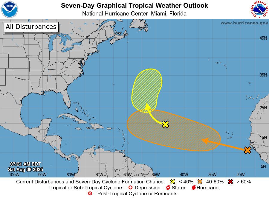
Focus in the Atlantic tropics has largely shifted to a tropical wave that splashed down yesterday, and is already up to a medium chance (40%) of tropical cyclone formation in 7 days. Environment ahead looks very favorable.
09.08.2025 12:01 — 👍 0 🔁 0 💬 0 📌 0
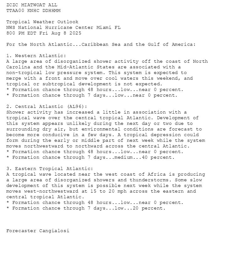
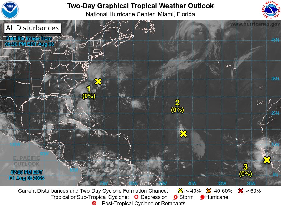
ZCZC MIATWOAT ALL<br>TTAA00 KNHC DDHHMM<br><br>Tropical Weather Outlook<br>NWS National Hurricane Center Miami FL<br>800 PM EDT Fri Aug 8 2025<br><br>For the North Atlantic...Caribbean Sea and the Gulf of America:<br><br>1. Western Atlantic:<br>A large area of disorganized shower activity off the coast of North <br>Carolina and the Mid-Atlantic States are associated with a <br>non-tropical low pressure system. This system is expected to <br>merge with a front and move over cool waters this weekend, and <br>tropical or subtropical development is not expected.<br>* Formation chance through 48 hours...low...near 0 percent.<br>* Formation chance through 7 days...low...near 0 percent.<br><br>2. Central Atlantic (AL96):<br>Shower activity has increased a little in association with a <br>tropical wave over the central tropical Atlantic. Development of <br>this system appears unlikely during the next day or two due to <br>surrounding dry air, but environmental conditions are forecast to <br>become more conducive in a few days. A tropical depression could <br>form during the early or middle part of next week while the system <br>moves northwestward to northward across the central Atlantic.<br>* Formation chance through 48 hours...low...near 0 percent.<br>* Formation chance through 7 days...medium...40 percent.<br><br>3. Eastern Tropical Atlantic:<br>A tropical wave located near the west coast of Africa is producing <br>a large area of disorganized showers and thunderstorms. Some slow <br>development of this system is possible next week while the system <br>moves west-northwestward at 15 to 20 mph across the eastern and <br>central tropical Atlantic.<br>* Formation chance through 48 hours...low...near 0 percent.<br>* Formation chance through 7 days...low...20 percent.<br><br><br><br>Forecaster Cangialosi<br><br><br>
Atlantic 2-Day Graphical Outlook Image
Atlantic 7-Day Graphical Outlook Image
NHC Atlantic Outlook update for Fri, 08 Aug 2025 23:08:51 UTC
Additional Details Here.
08.08.2025 23:10 — 👍 5 🔁 3 💬 0 📌 2
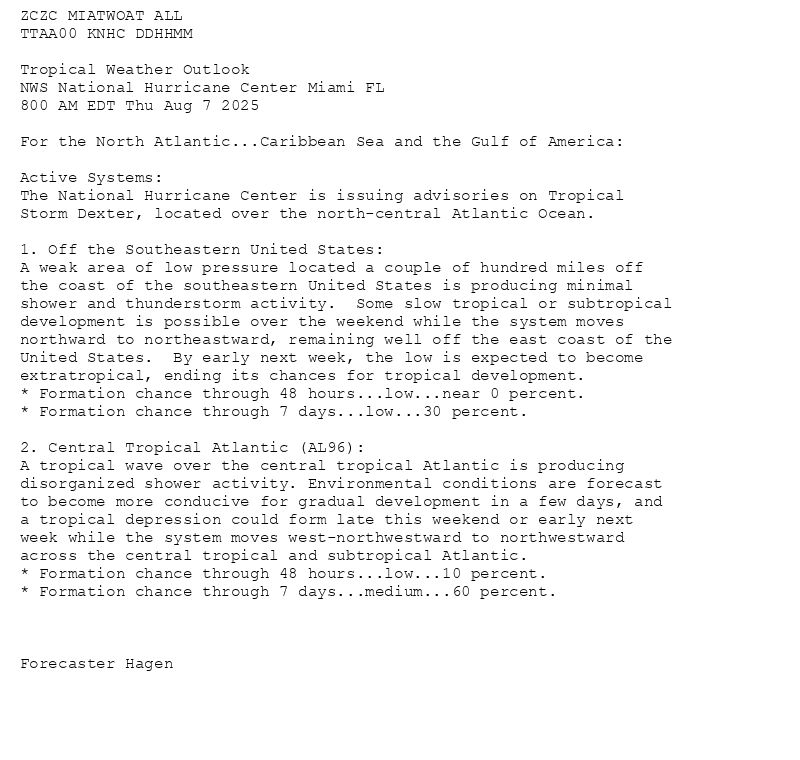
ZCZC MIATWOAT ALL<br>TTAA00 KNHC DDHHMM<br><br>Tropical Weather Outlook<br>NWS National Hurricane Center Miami FL<br>800 AM EDT Thu Aug 7 2025<br><br>For the North Atlantic...Caribbean Sea and the Gulf of America:<br><br>Active Systems:<br>The National Hurricane Center is issuing advisories on Tropical <br>Storm Dexter, located over the north-central Atlantic Ocean.<br><br>1. Off the Southeastern United States:<br>A weak area of low pressure located a couple of hundred miles off <br>the coast of the southeastern United States is producing minimal <br>shower and thunderstorm activity. Some slow tropical or subtropical <br>development is possible over the weekend while the system moves <br>northward to northeastward, remaining well off the east coast of the <br>United States. By early next week, the low is expected to become <br>extratropical, ending its chances for tropical development.<br>* Formation chance through 48 hours...low...near 0 percent.<br>* Formation chance through 7 days...low...30 percent.<br><br>2. Central Tropical Atlantic (AL96):<br>A tropical wave over the central tropical Atlantic is producing <br>disorganized shower activity. Environmental conditions are forecast <br>to become more conducive for gradual development in a few days, and <br>a tropical depression could form late this weekend or early next <br>week while the system moves west-northwestward to northwestward <br>across the central tropical and subtropical Atlantic.<br>* Formation chance through 48 hours...low...10 percent.<br>* Formation chance through 7 days...medium...60 percent.<br><br><br><br>Forecaster Hagen<br><br><br>
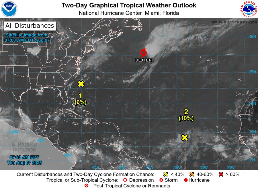
Atlantic 2-Day Graphical Outlook Image
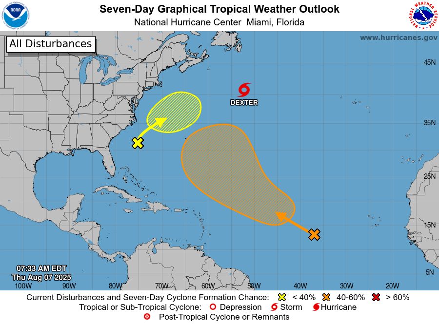
Atlantic 7-Day Graphical Outlook Image
NHC Atlantic Outlook update for Thu, 07 Aug 2025 11:33:39 UTC
Additional Details Here.
07.08.2025 11:40 — 👍 4 🔁 2 💬 0 📌 0
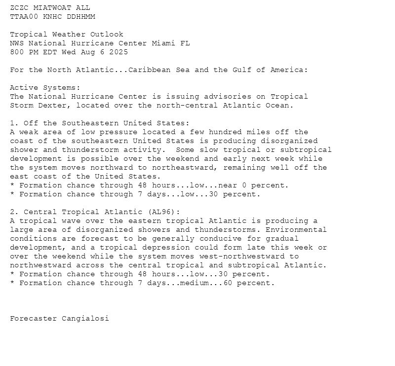
ZCZC MIATWOAT ALL<br>TTAA00 KNHC DDHHMM<br><br>Tropical Weather Outlook<br>NWS National Hurricane Center Miami FL<br>800 PM EDT Wed Aug 6 2025<br><br>For the North Atlantic...Caribbean Sea and the Gulf of America:<br><br>Active Systems:<br>The National Hurricane Center is issuing advisories on Tropical <br>Storm Dexter, located over the north-central Atlantic Ocean.<br><br>1. Off the Southeastern United States:<br>A weak area of low pressure located a few hundred miles off the <br>coast of the southeastern United States is producing disorganized <br>shower and thunderstorm activity. Some slow tropical or subtropical <br>development is possible over the weekend and early next week while <br>the system moves northward to northeastward, remaining well off the <br>east coast of the United States.<br>* Formation chance through 48 hours...low...near 0 percent.<br>* Formation chance through 7 days...low...30 percent.<br><br>2. Central Tropical Atlantic (AL96):<br>A tropical wave over the eastern tropical Atlantic is producing a <br>large area of disorganized showers and thunderstorms. Environmental <br>conditions are forecast to be generally conducive for gradual <br>development, and a tropical depression could form late this week or <br>over the weekend while the system moves west-northwestward to <br>northwestward across the central tropical and subtropical Atlantic.<br>* Formation chance through 48 hours...low...30 percent.<br>* Formation chance through 7 days...medium...60 percent.<br><br><br><br>Forecaster Cangialosi<br><br><br>
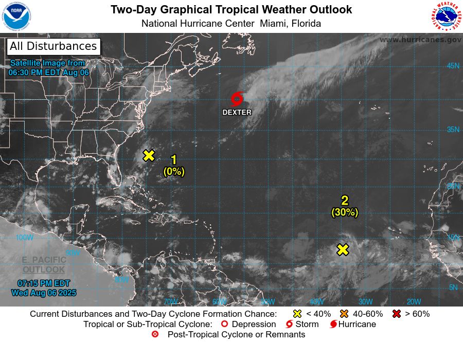
Atlantic 2-Day Graphical Outlook Image

Atlantic 7-Day Graphical Outlook Image
NHC Atlantic Outlook update for Wed, 06 Aug 2025 23:16:00 UTC
Additional Details Here.
06.08.2025 23:20 — 👍 11 🔁 6 💬 0 📌 0
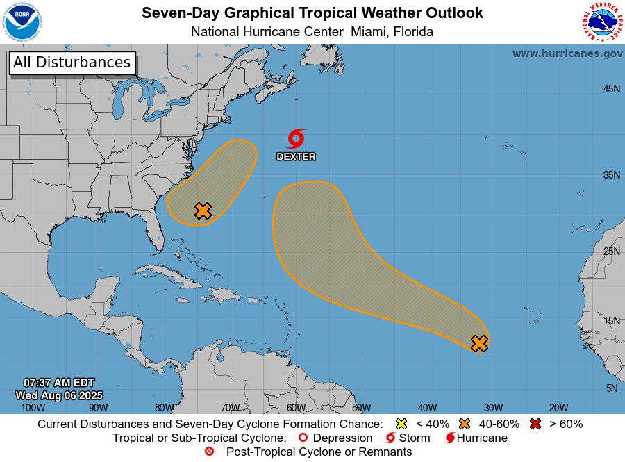
The weather remains active around the U.S this week. 2 areas of interest for TC development remain active in the Atlantic as Dexter Re-strengthens while moving east. AOIs are at 40% and 60% chances of developing.
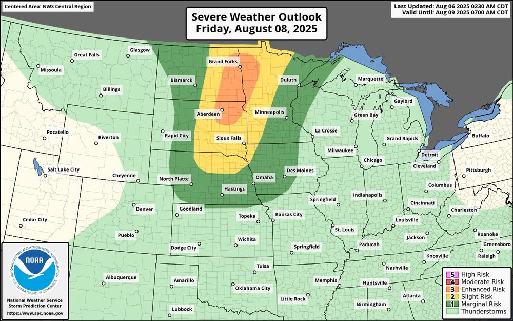
Severe weather is also likely on Friday in the Dakotas and MN.
06.08.2025 12:03 — 👍 0 🔁 0 💬 0 📌 0
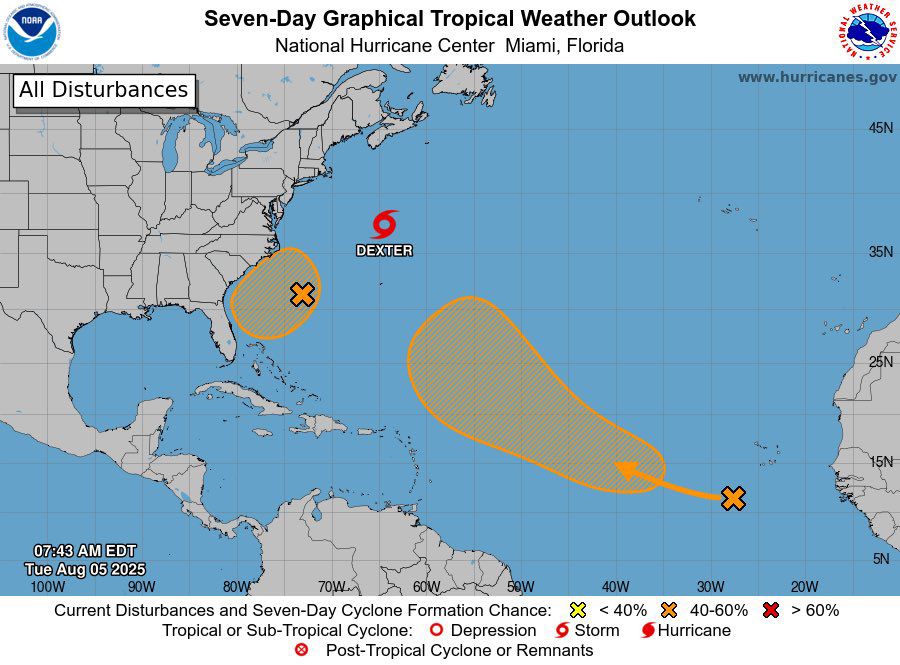
Dexter continues to move out to sea and has weakened a bit.
Otherwise, our 2 areas of interest remain active, now both at a medium chance of developing.
05.08.2025 11:53 — 👍 0 🔁 0 💬 0 📌 0
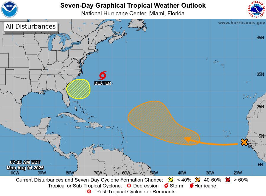
Dexter is moving out to sea this morning. Otherwise, 2 areas of interest remain active in the Atlantic, now up to 30% and 50% chances of developing respectively.
04.08.2025 12:06 — 👍 0 🔁 0 💬 0 📌 0
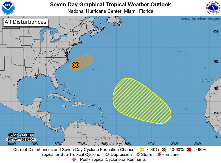
The Atlantic looks to be active to kick off August.
Invest 95L is about to become a tropical cyclone. (70%)
An area of interest in the open ATL now has a medium chance of developing. (40%)
An area of interest near 95L may develop later this week. (20%)
03.08.2025 17:51 — 👍 0 🔁 0 💬 0 📌 0
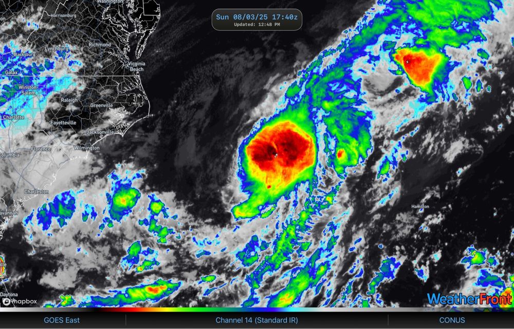
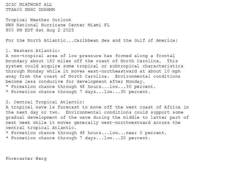
The Atlantic has started to wake up as we enter august.
An area of interest (95L) off the east coast has a 50% chance of becoming a tropical cyclone before Tuesday.
An area of interest in the MDR has a 30% chance of developing later this week.
03.08.2025 11:38 — 👍 0 🔁 0 💬 0 📌 0
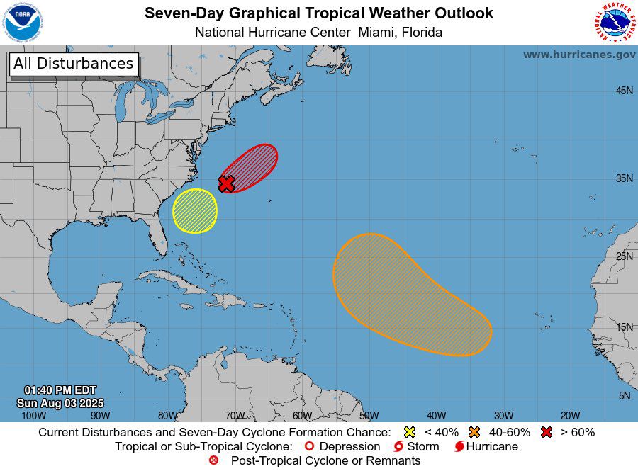
ZCZC MIATWOAT ALL<br>TTAA00 KNHC DDHHMM<br><br>Tropical Weather Outlook<br>NWS National Hurricane Center Miami FL<br>800 PM EDT Sat Aug 2 2025<br><br>For the North Atlantic...Caribbean Sea and the Gulf of America:<br><br>1. Western Atlantic:<br>A non-tropical area of low pressure has formed along a frontal <br>boundary about 150 miles off the coast of North Carolina. This <br>system could acquire some tropical or subtropical characteristics <br>through Monday while it moves east-northeastward at about 10 mph <br>away from the coast of North Carolina. Environmental conditions <br>become less conducive for development after Monday.<br>* Formation chance through 48 hours...low...30 percent.<br>* Formation chance through 7 days...low...30 percent.<br><br>2. Central Tropical Atlantic:<br>A tropical wave is forecast to move off the west coast of Africa in <br>the next day or two. Environmental conditions could support some <br>gradual development of the wave during the middle to latter part of <br>next week while it moves generally west-northwestward across the <br>central tropical Atlantic.<br>* Formation chance through 48 hours...low...near 0 percent.<br>* Formation chance through 7 days...low...20 percent.<br><br><br><br>Forecaster Berg<br><br><br>
Atlantic 2-Day Graphical Outlook Image
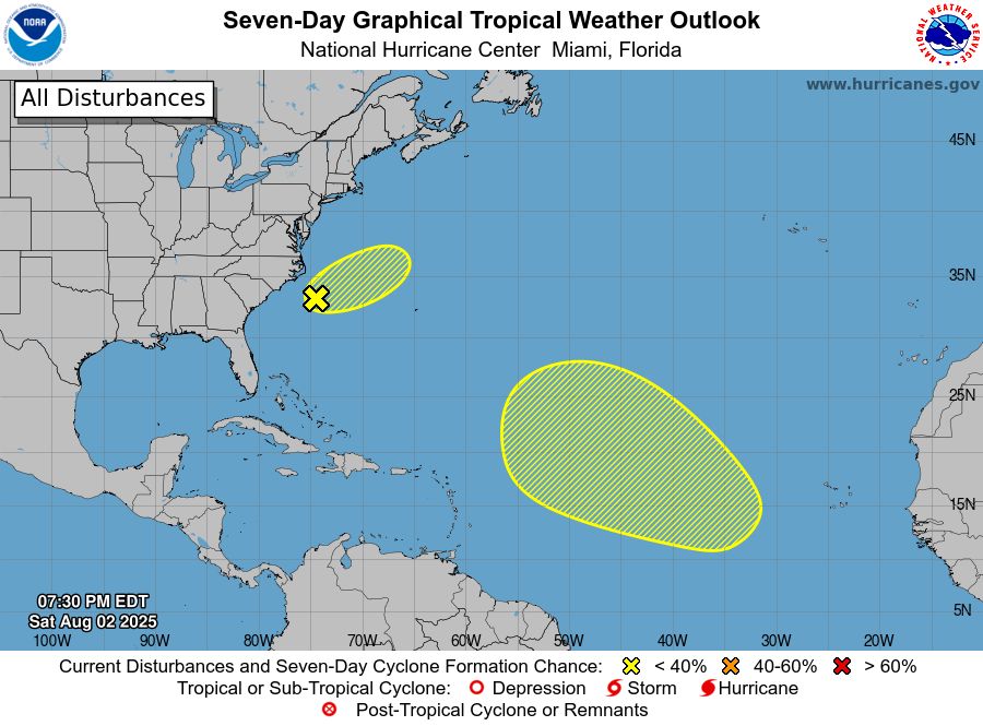
Atlantic 7-Day Graphical Outlook Image
NHC Atlantic Outlook update for Sat, 02 Aug 2025 23:30:31 UTC
Additional Details Here.
02.08.2025 23:40 — 👍 13 🔁 10 💬 0 📌 1
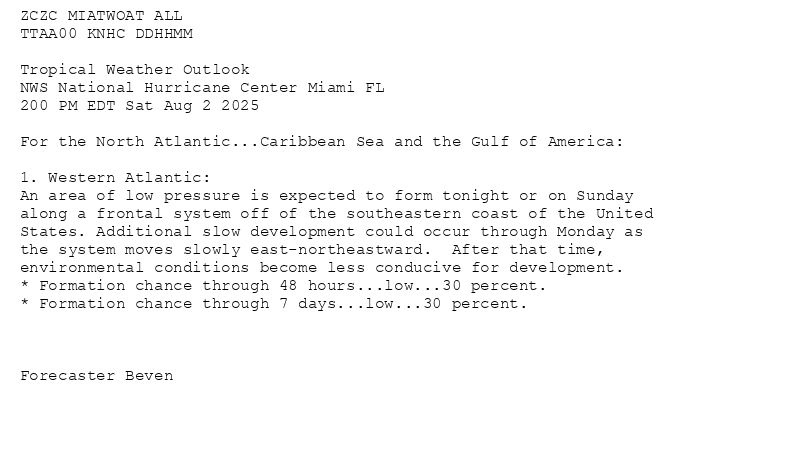
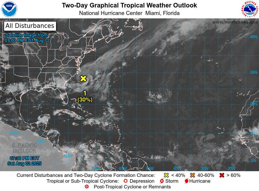
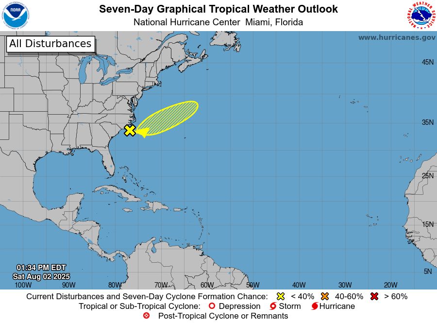
ZCZC MIATWOAT ALL<br>TTAA00 KNHC DDHHMM<br><br>Tropical Weather Outlook<br>NWS National Hurricane Center Miami FL<br>200 PM EDT Sat Aug 2 2025<br><br>For the North Atlantic...Caribbean Sea and the Gulf of America:<br><br>1. Western Atlantic:<br>An area of low pressure is expected to form tonight or on Sunday <br>along a frontal system off of the southeastern coast of the United <br>States. Additional slow development could occur through Monday as <br>the system moves slowly east-northeastward. After that time, <br>environmental conditions become less conducive for development.<br>* Formation chance through 48 hours...low...30 percent.<br>* Formation chance through 7 days...low...30 percent.<br><br><br><br>Forecaster Beven<br><br><br>
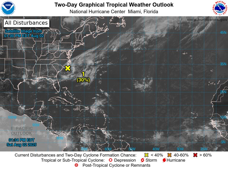
Atlantic 2-Day Graphical Outlook Image
Atlantic 7-Day Graphical Outlook Image
NHC Atlantic Outlook update for Sat, 02 Aug 2025 17:34:58 UTC
Additional Details Here.
02.08.2025 17:40 — 👍 9 🔁 4 💬 0 📌 0
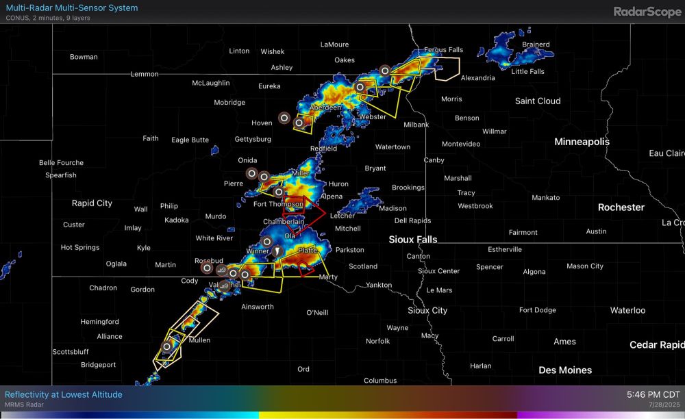
Coverage of severe thunderstorms has begun gradually increasing throughout the last hour and looks likely to accelerate over the next 30 minutes roughly. A strong linear complex with wind gusts >80-90mph should be forming as a result.
28.07.2025 22:50 — 👍 0 🔁 0 💬 0 📌 0
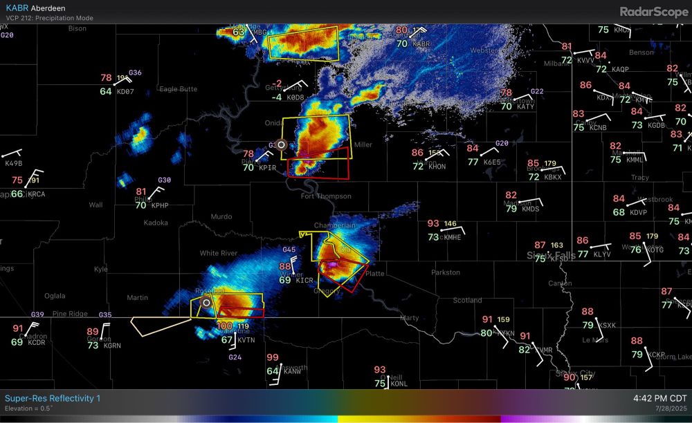
Handful of tornadic supercells in progress in South Dakota into Nebraska in the short term.
28.07.2025 21:44 — 👍 0 🔁 0 💬 0 📌 0
MDT has been expanded deep into S MN and into northern IA.
28.07.2025 16:39 — 👍 0 🔁 0 💬 0 📌 0
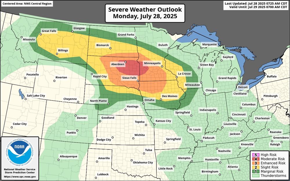
A swath of widespread wind damage (with some gusts >80-90mph) appear possible this evening into the early overnight hours across the eastern Dakotas into southern Minnesota. A couple tornadoes and large hail are also possible.
28.07.2025 13:03 — 👍 0 🔁 0 💬 0 📌 1
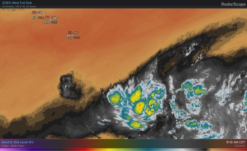
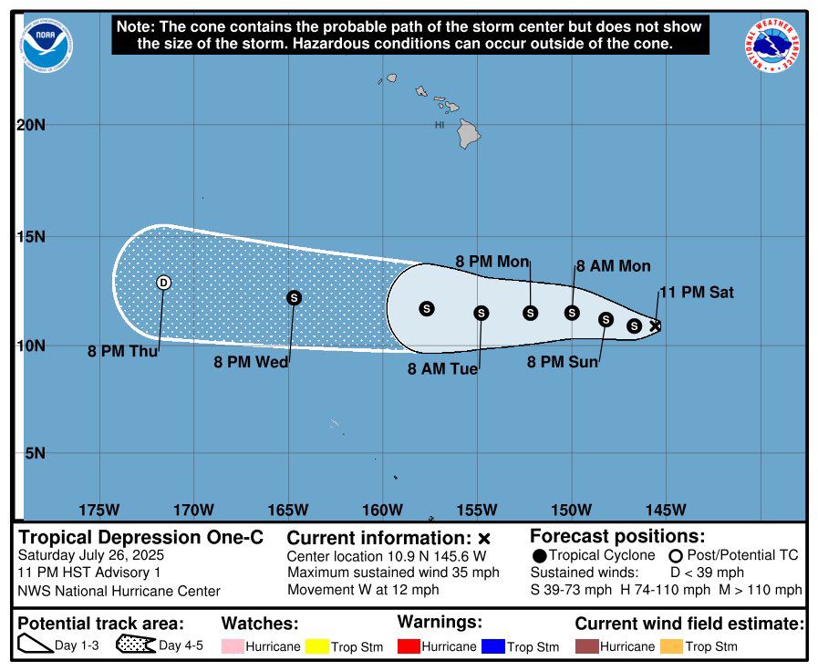
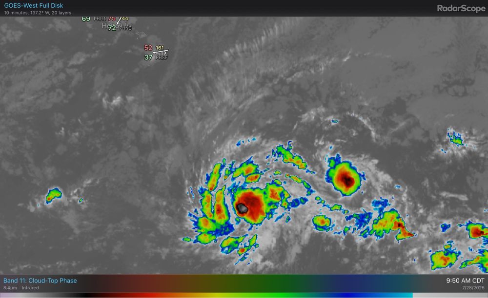
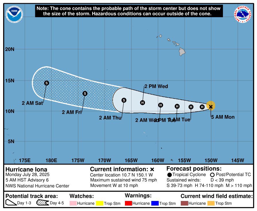
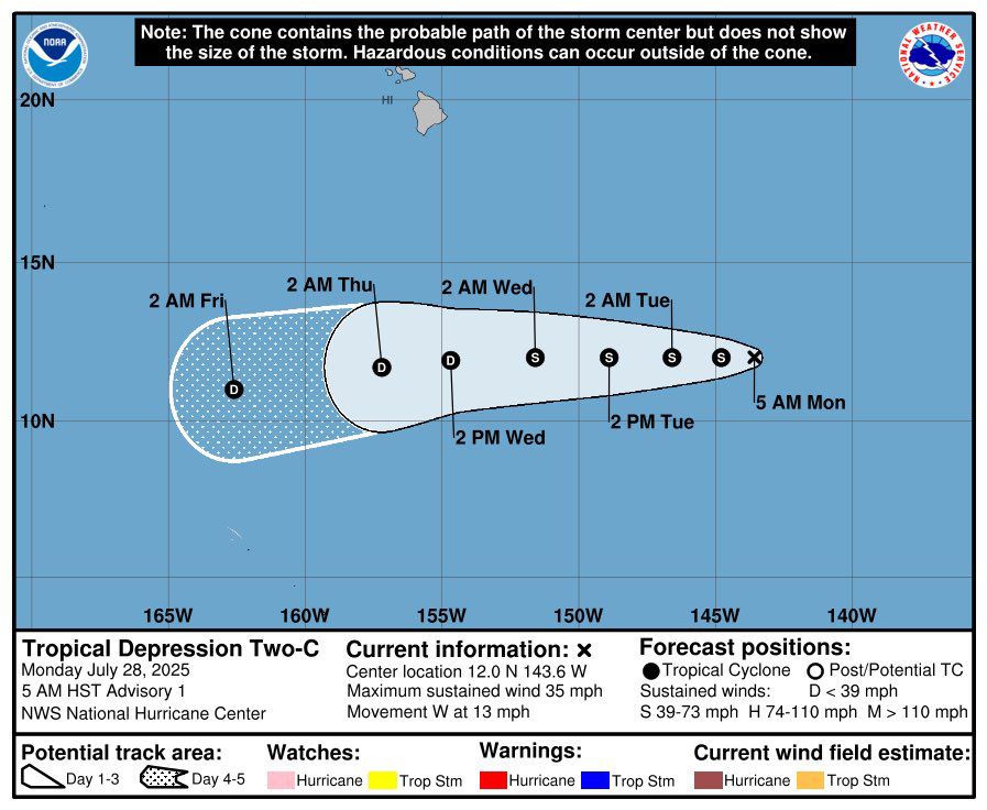
A tropical depression has formed well south of Hawaii and should move steadily westward through the next few days.
27.07.2025 11:26 — 👍 0 🔁 0 💬 0 📌 0
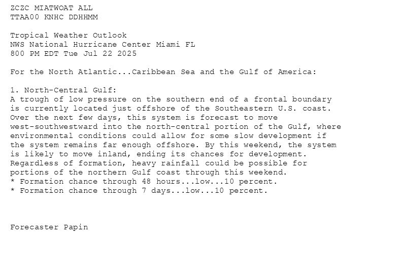
ZCZC MIATWOAT ALL<br>TTAA00 KNHC DDHHMM<br><br>Tropical Weather Outlook<br>NWS National Hurricane Center Miami FL<br>800 PM EDT Tue Jul 22 2025<br><br>For the North Atlantic...Caribbean Sea and the Gulf of America:<br><br>1. North-Central Gulf:<br>A trough of low pressure on the southern end of a frontal boundary <br>is currently located just offshore of the Southeastern U.S. coast. <br>Over the next few days, this system is forecast to move <br>west-southwestward into the north-central portion of the Gulf, where <br>environmental conditions could allow for some slow development if <br>the system remains far enough offshore. By this weekend, the system <br>is likely to move inland, ending its chances for development. <br>Regardless of formation, heavy rainfall could be possible for <br>portions of the northern Gulf coast through this weekend.<br>* Formation chance through 48 hours...low...10 percent.<br>* Formation chance through 7 days...low...10 percent.<br><br><br><br>Forecaster Papin<br><br><br>
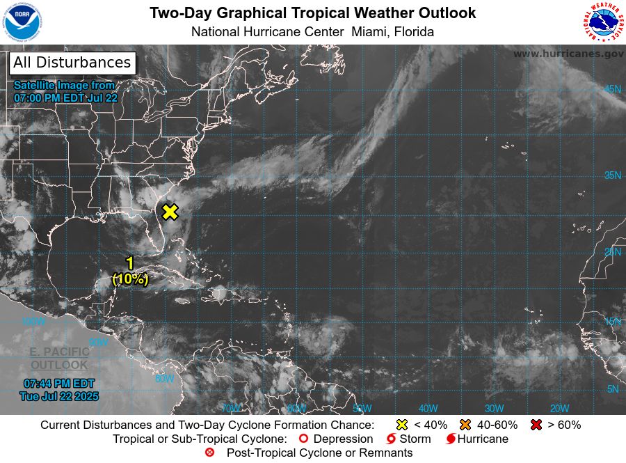
Atlantic 2-Day Graphical Outlook Image
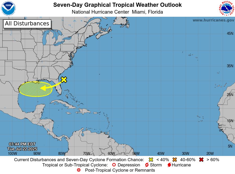
Atlantic 7-Day Graphical Outlook Image
NHC Atlantic Outlook update for Tue, 22 Jul 2025 23:45:07 UTC
Additional Details Here.
22.07.2025 23:50 — 👍 10 🔁 6 💬 0 📌 3
ZCZC MIATWOAT ALL<br>TTAA00 KNHC DDHHMM<br><br>Tropical Weather Outlook<br>NWS National Hurricane Center Miami FL<br>800 PM EDT Fri Jul 18 2025<br><br>For the North Atlantic...Caribbean Sea and the Gulf of America:<br><br>1. Central Tropical Atlantic:<br>A tropical wave interacting with a broad area of low pressure is <br>producing disorganized showers and thunderstorms more than 800 miles <br>southwest of the Cabo Verde Islands. Environmental conditions could <br>become marginally conducive for gradual development late this <br>weekend through early next week as the system moves westward to <br>west-northwestward around 10 mph. By the middle of next week, <br>environmental conditions are forecast to become unfavorable for <br>further development.<br>* Formation chance through 48 hours...low...near 0 percent.<br>* Formation chance through 7 days...low...20 percent.<br><br><br><br>Forecaster Hagen<br><br><br>
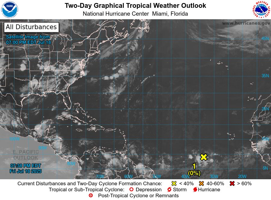
Atlantic 2-Day Graphical Outlook Image
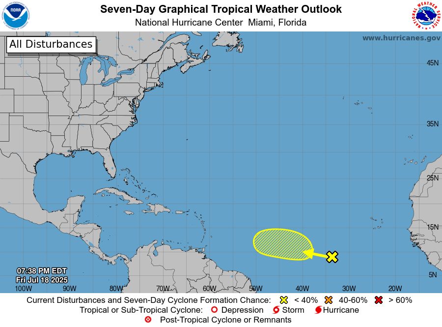
Atlantic 7-Day Graphical Outlook Image
NHC Atlantic Outlook update for Fri, 18 Jul 2025 23:38:26 UTC
Additional Details Here.
18.07.2025 23:40 — 👍 13 🔁 5 💬 0 📌 2
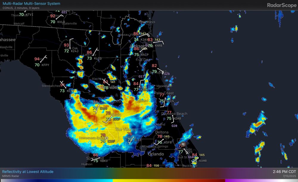
Invest 93L is moving inland over Florida, and chances are increasing that it stays inland. However, strong winds and heavy rain remain possible throughout the day in Florida into the southeast through the next few days.
15.07.2025 19:50 — 👍 0 🔁 0 💬 0 📌 0
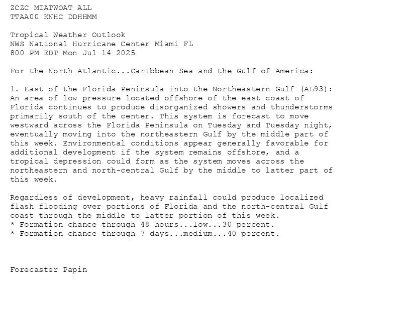
ZCZC MIATWOAT ALL<br>TTAA00 KNHC DDHHMM<br><br>Tropical Weather Outlook<br>NWS National Hurricane Center Miami FL<br>800 PM EDT Mon Jul 14 2025<br><br>For the North Atlantic...Caribbean Sea and the Gulf of America:<br><br>1. East of the Florida Peninsula into the Northeastern Gulf (AL93):<br>An area of low pressure located offshore of the east coast of <br>Florida continues to produce disorganized showers and thunderstorms <br>primarily south of the center. This system is forecast to move <br>westward across the Florida Peninsula on Tuesday and Tuesday night, <br>eventually moving into the northeastern Gulf by the middle part of <br>this week. Environmental conditions appear generally favorable for <br>additional development if the system remains offshore, and a <br>tropical depression could form as the system moves across the <br>northeastern and north-central Gulf by the middle to latter part of <br>this week.<br><br>Regardless of development, heavy rainfall could produce localized <br>flash flooding over portions of Florida and the north-central Gulf <br>coast through the middle to latter portion of this week.<br>* Formation chance through 48 hours...low...30 percent.<br>* Formation chance through 7 days...medium...40 percent.<br><br><br><br>Forecaster Papin<br><br><br>
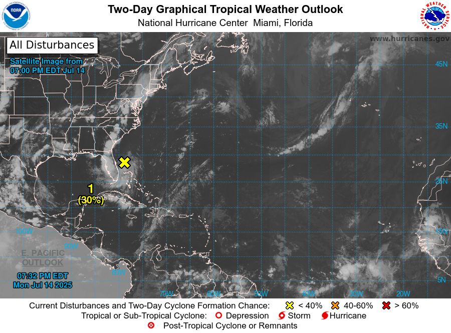
Atlantic 2-Day Graphical Outlook Image
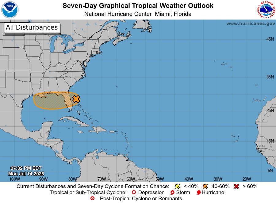
Atlantic 7-Day Graphical Outlook Image
NHC Atlantic Outlook update for Mon, 14 Jul 2025 23:32:20 UTC
Additional Details Here.
14.07.2025 23:40 — 👍 13 🔁 7 💬 0 📌 0
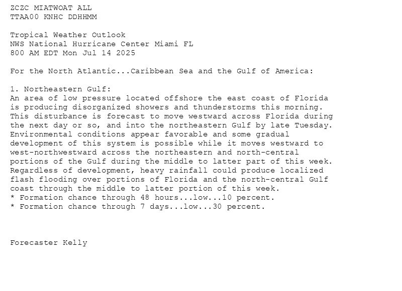
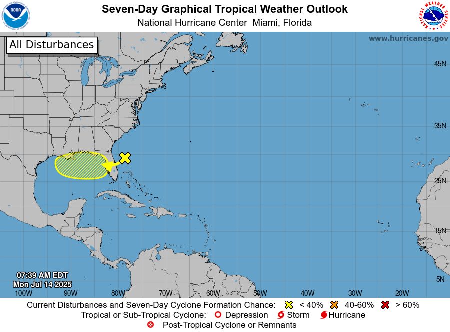
ZCZC MIATWOAT ALL<br>TTAA00 KNHC DDHHMM<br><br>Tropical Weather Outlook<br>NWS National Hurricane Center Miami FL<br>800 AM EDT Mon Jul 14 2025<br><br>For the North Atlantic...Caribbean Sea and the Gulf of America:<br><br>1. Northeastern Gulf:<br>An area of low pressure located offshore the east coast of Florida <br>is producing disorganized showers and thunderstorms this morning. <br>This disturbance is forecast to move westward across Florida during <br>the next day or so, and into the northeastern Gulf by late Tuesday. <br>Environmental conditions appear favorable and some gradual <br>development of this system is possible while it moves westward to <br>west-northwestward across the northeastern and north-central <br>portions of the Gulf during the middle to latter part of this week. <br>Regardless of development, heavy rainfall could produce localized <br>flash flooding over portions of Florida and the north-central Gulf <br>coast through the middle to latter portion of this week.<br>* Formation chance through 48 hours...low...10 percent.<br>* Formation chance through 7 days...low...30 percent.<br><br><br><br>Forecaster Kelly<br><br><br>
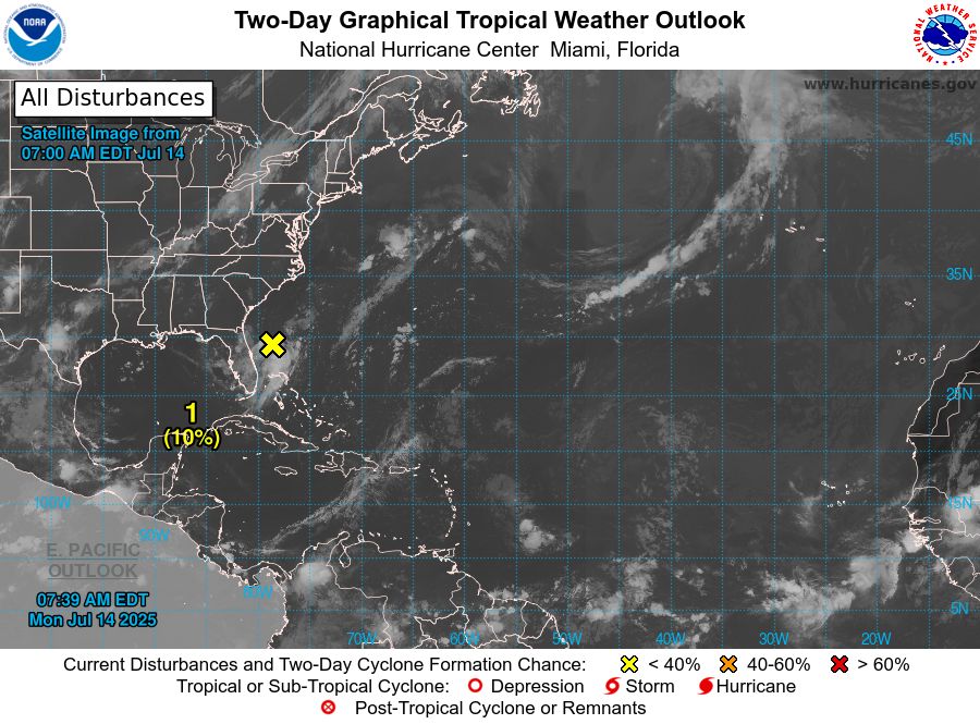
Atlantic 2-Day Graphical Outlook Image
Atlantic 7-Day Graphical Outlook Image
NHC Atlantic Outlook update for Mon, 14 Jul 2025 11:39:17 UTC
Additional Details Here.
14.07.2025 11:40 — 👍 10 🔁 4 💬 0 📌 0
Outside of tropics, another considerable flash flooding threat exists today over Southern Texas, similar areas where a very destructive flooding event occurred about 10 days ago.
13.07.2025 13:48 — 👍 0 🔁 0 💬 0 📌 0

There is a low chance (20%) area of interest for tropical development over the next 7 days this week, set along the Gulf Coast.
13.07.2025 13:26 — 👍 0 🔁 0 💬 0 📌 0
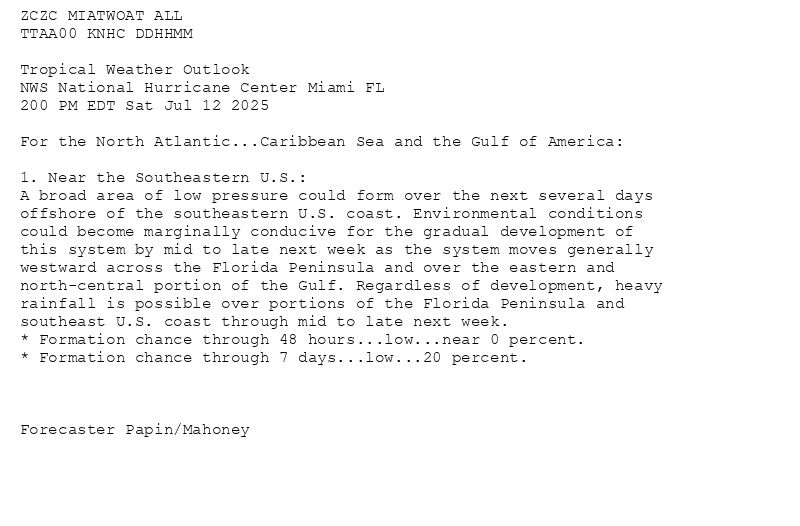
ZCZC MIATWOAT ALL<br>TTAA00 KNHC DDHHMM<br><br>Tropical Weather Outlook<br>NWS National Hurricane Center Miami FL<br>200 PM EDT Sat Jul 12 2025<br><br>For the North Atlantic...Caribbean Sea and the Gulf of America:<br><br>1. Near the Southeastern U.S.:<br>A broad area of low pressure could form over the next several days <br>offshore of the southeastern U.S. coast. Environmental conditions <br>could become marginally conducive for the gradual development of <br>this system by mid to late next week as the system moves generally <br>westward across the Florida Peninsula and over the eastern and <br>north-central portion of the Gulf. Regardless of development, heavy <br>rainfall is possible over portions of the Florida Peninsula and <br>southeast U.S. coast through mid to late next week.<br>* Formation chance through 48 hours...low...near 0 percent.<br>* Formation chance through 7 days...low...20 percent.<br><br><br><br>Forecaster Papin/Mahoney<br><br><br>
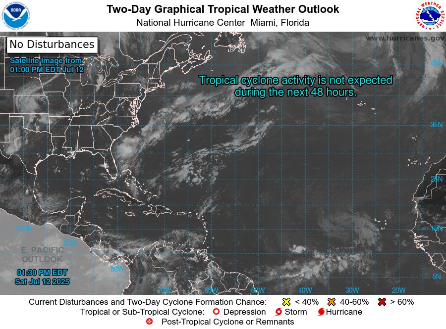
Atlantic 2-Day Graphical Outlook Image
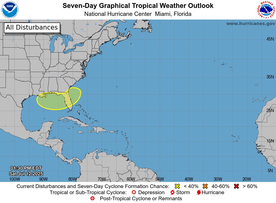
Atlantic 7-Day Graphical Outlook Image
NHC Atlantic Outlook update for Sat, 12 Jul 2025 17:30:58 UTC
Additional Details Here.
12.07.2025 17:40 — 👍 15 🔁 10 💬 0 📌 2
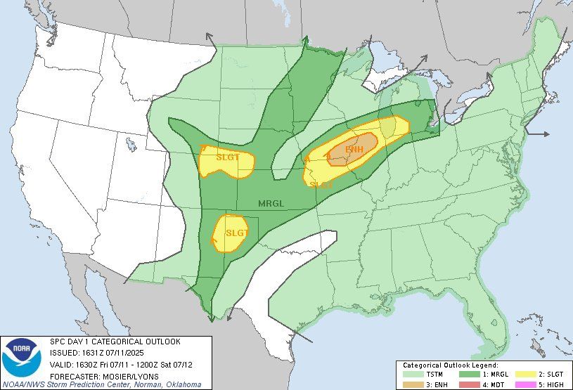
10% tornado risk present over the IA/IL border this afternoon.
11.07.2025 18:27 — 👍 0 🔁 0 💬 0 📌 0
Tropical Storm Chantal is now inland over the Carolina’s, and will be producing heavy rain and strong winds throughout the day in those states, as it weakens and eventually dissipates.
06.07.2025 13:46 — 👍 0 🔁 0 💬 0 📌 0
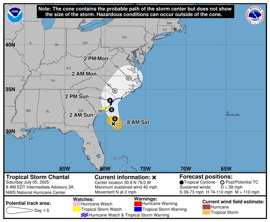
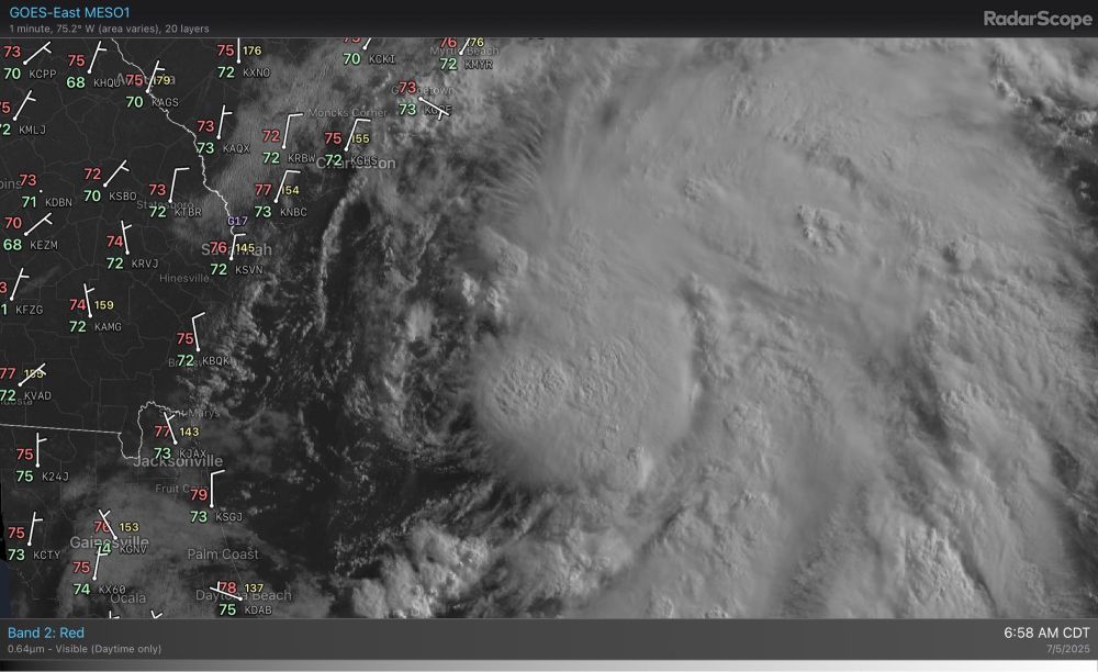
Newly named Tropical Storm Chantal is slowly progressing toward the coast of The Carolina’s today. Tropical Storm Warnings have been issued along the coastline.
05.07.2025 12:02 — 👍 0 🔁 0 💬 0 📌 0
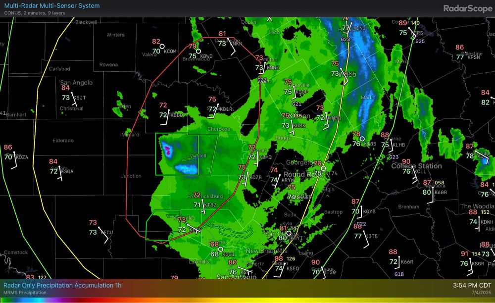
Outside of Tropical Depression Three, a major flooding event has been occurring in a small corridor in central texas, with precipitation rates sustaining locally up to ~2 inches/hr via radar. Flash flood warnings (and 2 emergencies) have been issued in the area.
04.07.2025 21:00 — 👍 0 🔁 0 💬 0 📌 0
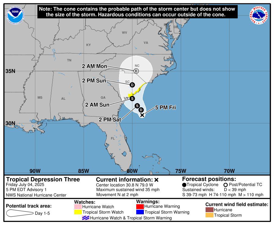
Tropical Depression Three has formed off the coast of the Southeast US this evening, and may make landfall on Sunday as a tropical storm; strong winds and heavy rain possible. Tropical Storm Watches have been issued.
04.07.2025 20:47 — 👍 0 🔁 0 💬 0 📌 0