🌙 Satellite data on nighttime light reveals that areas with higher solar adoption experience less severe declines during load shedding. Conversely, majority Black African neighborhoods see nighttime light reductions twice as large as those in white areas. #LoadSheddin 5/5
21.05.2025 08:52 — 👍 0 🔁 0 💬 0 📌 0
📊 The disparities are stark. Majority-white census tracts boast an average of 3.5 m² of solar panels per person. In contrast, areas predominantly inhabited by Black, Coloured, and Indian populations have just 0.048 m² per person—a 73-fold difference. #ApartheidLegacy 4/5
21.05.2025 08:52 — 👍 0 🔁 0 💬 1 📌 0
🔍 Between 2016 and 2023, household solar installations in South Africa grew by an astounding 140% annually. However, this growth is uneven: high-income areas average nearly 2 panels per household, while low-income neighborhoods have virtually none. #SolarInequality 3/5
21.05.2025 08:52 — 👍 0 🔁 0 💬 1 📌 0
Read more here: theconversation.com/satellite-im... Paper here: iopscience.iop.org/article/10.1... 2/5
21.05.2025 08:52 — 👍 0 🔁 0 💬 1 📌 0

🚨 New research reveals that South Africa's solar boom is deepening inequality. While rooftop solar adoption has surged, it's predominantly benefiting wealthier, white communities. Meanwhile, poorer, Black-majority areas remain in the dark. #EnergyJustice #LoadShedding 1/5
21.05.2025 08:52 — 👍 0 🔁 0 💬 1 📌 0
Norway’s leading institution for applied ecological research, delivering knowledge and solutions across public and private sectors, focusing on nature and the interactions between nature and society.
www.nina.no
ADHO Special Interest Group focused on Digital Approaches to Spatial Humanities.
Humboldt´s Earth Observation Lab focuses on a better understanding of coupled human-environment systems based on remote sensing data and geoinformation.
https://eolab.geographie.hu-berlin.de
🇨🇴Ph.D. (c) Temple University
Geography| Land System Science| Remote Sensing| Environmental Studies| Geovisualization| Political Ecology| Wildlife conservation
https://t.co/vhD0ZpCIhB
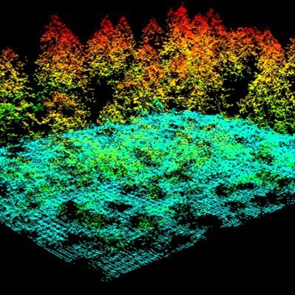
🌲 PhD student in forestry remote sensing at forstunigoe.bsky.social
🛰 Researching forest structures using LiDAR and imagery
🌍 Passionate about forests, climate, and open geospatial data
https://fosstodon.org/@flofranz
https://github.com/FloFranz
Forest Inventory and monitoring group (NMBU)
Using remote sensing to increase our knowledge of forests and forest-related resources.
https://www.forestinventory.no/
The ABMI is a global leader in biodiversity monitoring. We tell the factual story of Alberta’s wildlife & ecosystems through high quality data & information.
Cutting-edge research on global environmental changes from University of Maryland’s Department of Geographical Sciences. #remotesensing #gis #geospatialscience
The GRI (at University of Canterbury, New Zealand) provides a unique opportunity for all branches of the geospatial community to communicate and collaborate. https://geospatial.ac.nz/
Researcher 👩🏾💻 Cities and transportation policy | Sociology PhD 🔬 Immigration, social & political inequality | also here to chit chat about 📺 TV and movies, 📚 books, 🧶 fiber arts, 🌱gardening | 🇩🇪 🇱🇰 🇺🇸 she/her
Researcher at @czp.cuni.cz @charlesuni.cuni.cz | Research on #Geoinformatics Applications, Land Change Science, #UHIs and Ecosystem Services 🇻🇳🇨🇿
https://linktr.ee/trongcan.ng
#Satellites #Science #SeaIce #ExtremeLatitudes.
Remote Sensing of Polar Regions at University of Bremen,
Institute of Environmental Physics (IUP).
https://seaice.uni-bremen.de
Product manager on Google Maps driving + walking, and that little bit at the end that says you've arrived. I dream of a beautiful place in the mountains to call home. 日本語でもたまには書きます
📍Tokyo by way of Boulder and Zurich
Belize GEO: Belize Group on Earth Observation & GIS. Shares SciComm re: EO, GIS relevant to Belize, the Caribbean, and other regions. Administered by a real live Belizean scientist.
CEO @Spatial Bytes | Research Scientist & Senior Geospatial Engineer @DRI | Creator, GEE Community Catalog | Google Dev Expert for Google Earth Engine | NSF NEON Advisor | Faculty @UH Mānoa | Geospatial Innovation 🌍
Open source #python software developer and teacher. Pandas core developer. GeoPandas and Shapely maintainer. Apache Arrow PMC.
Software engineer at fused.io
Computational geographer. Associate Professor at AMU, Poznan, Poland. Co-author of http://r.geocompx.org, http://py.geocompx.org, and http://tmap.geocompx.org books. #rstats #rspatial #geocompx
https://jakubnowosad.com/
Associate Professor @UTKnoxville | Amazon Scholar | Creator of #geemap & #leafmap | Talk about #Geospatial #GeoPython #DataViz #GIS #FOSS #EarthEngine
Entertaining & educational conversations about science, tech, + more. Hosted by Ira Flatow and Flora Lichtman. From WNYCStudios.
official Bluesky account (check username👆)
Bugs, feature requests, feedback: support@bsky.app