📅 Join us for a hybrid seminar with Associate Research Professor Michael Humber on using satellite data and spatial analysis to map Maryland's agricultural climate vulnerability, via @crnatumd.bsky.social
go.umd.edu/23fy
@umdgeography.bsky.social
Cutting-edge research on global environmental changes from University of Maryland’s Department of Geographical Sciences. #remotesensing #gis #geospatialscience
📅 Join us for a hybrid seminar with Associate Research Professor Michael Humber on using satellite data and spatial analysis to map Maryland's agricultural climate vulnerability, via @crnatumd.bsky.social
go.umd.edu/23fy

🌊 How is saltwater intrusion affecting Maryland's farmland?
UMD's @crnatumd.bsky.social's dashboard shows over 14,000 acres at risk, providing data for farmers and policymakers. Check it out: go.umd.edu/climate-impa...

📅 Join NASA's ARSET for a free online training on satellite remote sensing to study climate-sensitive infectious diseases, with GEOG Chair Tatiana Loboda tomorrow, Oct. 7, 11 a.m.-1 p.m. EDT. 2nd part with @mcwimberly.bsky.social on Thur. Register now: tinyurl.com/32zxw8yx
06.10.2025 18:31 — 👍 1 🔁 1 💬 0 📌 0
🚨 Grad program info sessions in #GeospatialSciences are coming up!
Advance your career or gain new skills in GIS, Remote Sensing & GEOINT.
📅 Oct 2 | 12 PM EDT – MS GIS & Certs
Register ▶️ lnkd.in/ehbhNKNn
📅 Oct 6 | 5 PM EDT – MS GEOINT & Cert
Register ▶️ lnkd.in/eC5X-xY5

❓Why would a scientist who tracks forests speak out about political AI? 🤖
Andres Hernandez-Serna of UMD's Global Land Analysis and Discovery team GLAD warns: the AI that maps forests is now shaping political messages without labels or accountability.
Learn more: go.umd.edu/political-ai...
🚨 Grad program info sessions in #GeospatialSciences are coming up!
Advance your career or gain new skills in GIS, Remote Sensing & GEOINT.
📅 Oct 2 | 12 PM EDT – MS GIS & Certs
Register ▶️ lnkd.in/ehbhNKNn
📅 Oct 6 | 5 PM EDT – MS GEOINT & Cert
Register ▶️ lnkd.in/eC5X-xY5
Do you work with local communities and want to share the important work that's been done? Then join our upcoming webinar with editorial board members from the Community Science Exchange and community members from projects that have published with us! #AGUPubs
26.09.2025 13:31 — 👍 0 🔁 1 💬 1 📌 0
It’s truly baffling to me that so many of these stories focus on “wow big fish” and not “this is an IUCN Red List Critically Endangered species that is extremely physiologically fragile and often does not survive fishing practices like this”
www.mysanantonio.com/news/south-t... 🦑🧪🌎🦈🐠

🚀 Just released: updated Land Cover Map Validation Guidelines led by UMD-GLAD's Alexandra (Sasha) Tyukavina.
These best practices help researchers & practitioners worldwide build more accurate, reliable land cover maps. Free & open to use.
Check it out: go.umd.edu/land-cover-m...

Tracking Africa’s crops just got easier. #HarvestStat Africa provides detailed subnational stats for 94 crops across 33 countries, freely available for research, forecasting & food security planning. 📊🌱
go.umd.edu/harveststat-...

"Cutting down the Amazon will bring extreme rain, wind and heat.
We used to think that deforestation in the Amazon would dry out the local climate, but the effects may be even more extreme and varied." 🌍 www.newscientist.com/article/2497...

Resources can be incredibly important for students at all levels of education. These can include connecting at meetings, earning awards and grants, taking advantage of professional development opportunities, or joining various groups and organizations.
Tailor these to your needs: buff.ly/JVcFGPj
#remotesensing #datascience
#ecology
Very nice piece - also in its presentation

Diego Cardenosa has loved sharks ever since he was a child. The Colombia native was never afraid of them when he visited his beloved beach. He was fascinated with how sharks moved through water using their multiple fins.
28.06.2024 21:30 — 👍 5 🔁 1 💬 0 📌 0
🦈🐘 Wildlife trade is a major driver of biodiversity loss.
At this ENST Seminar, Diego Cardeñosa (Florida International University) shares how science can shape policies to regulate it. GEOG students encouraged to attend 👉 go.umd.edu/enst-seminar...
📅 Wed, Sept. 17 | 🕒 3 pm | 📍 0408 ANSC
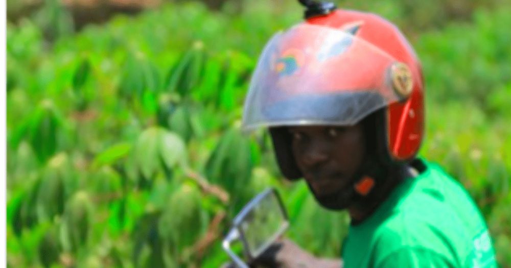
📹🏍️ Can a GoPro on a helmet transform how we map crops? Faculty specialist Diana Botchway Frimpong highlights work led by Assistant Professor Catherine Nakalembe (Ph.D.) using helmet cams + AI for low-cost, scalable agricultural data: go.umd.edu/helmets-labe...
11.09.2025 13:38 — 👍 0 🔁 0 💬 0 📌 0
🌟 Did you catch this? New Ph.D. student Michaelmary Chukwo guest-posted in @geographers.bsky.social newsletter on #AAG2025, sharing his experience chairing the Human Dynamics Symposium on Environmental Exposure, Mobility & Health.
www.aag.org/navigating-h...
🌍 Call for Papers! Submit to the Progress in Physical Geography special issue:
Coding Earth: Open Source Solutions in Physical Geography
📅 Deadline: 18 Dec 2025
🔗 journals.sagepub.com/home/ppg
#OpenSource #OpenScience #GISchat #RSpatial #GeoPython
In a recent interview, Dr. Webster Mohriak shares an overview of the topics covered in his two-book set Salt in the Earth Sciences, including salt deposition and giant salt basin. 📚
🎥 buff.ly/dL1wBEn
#SaltDeposition #evaporites #salt #AGUPubs #IMOG2025

🛰️ 🌏 UMD's Global Land Analysis and Discovery (GLAD) lab help advance a global dataset that improves disaster response, land-use monitoring and agricultural planning:
geog.umd.edu/featured-con...

🐍 How does a “wild” reptile from Germany end up in U.S. import records when it isn’t native to Europe?
Prof Meredith Gore & colleagues reviewed 20+ years of wildlife trade data, uncovering gaps that put biodiversity at risk.
🔗 go.umd.edu/wildlife-tra...
via @currentbiology.bsky.social

Engaging with the media is one of the best ways to raise awareness about your research to the public and #policymakers. Highlight your newsworthy research to @tandfresearch.bsky.social for the opportunity to work with journalists & some of the largest publications worldwide. buff.ly/SPkib5X #GeoSky
11.08.2025 12:45 — 👍 2 🔁 2 💬 0 📌 0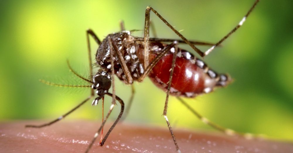
🦟 Fighting disease with satellite data 🛰️
Prof Tatiana Loboda has received a $1M grant from @nasaearth.bsky.social to develop satellite-based early warning systems for malaria and dengue in Indonesia.
Learn more: geog.umd.edu/featured-con...
🌍 Save the Date: Aug. 19 🌳
We’re pleased to welcome Drs. Thorsten Wiegand & Andreas Huth from the Helmholtz Centre for Environmental Research @ufz.de for a joint seminar event.
🌱 Forest spatial dynamics & species coexistence
🌲 Tropical forests & carbon cycle modeling
More details: go.umd.edu/20qa
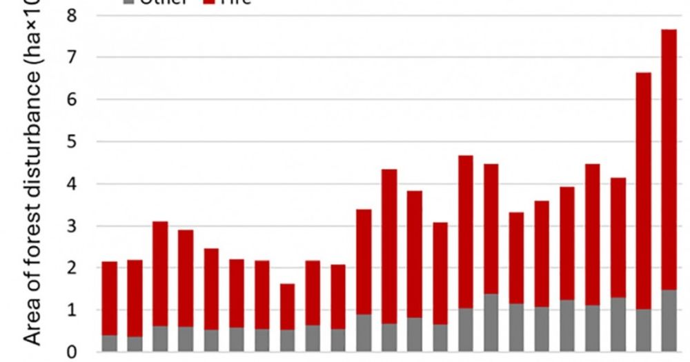
If you thought forest fires were getting worse, you’re right 🌍🔥
UMD's GLAD lab found record-breaking forest loss in 2023–2024, with fires now driving over 40% of global forest disturbance.
Learn more: go.umd.edu/record-wildf...
#climatechange #wildfire
How do different types of forest regrowth impact carbon recovery?
Xueyuan (Eric) Gao (Ph.D. ’24), now postdoc at Princeton, tackled this in a Nature Communications paper that earned ESA’s 2025 Early Career Ecologists Outstanding Paper Award 🎉
geog.umd.edu/featured-con...
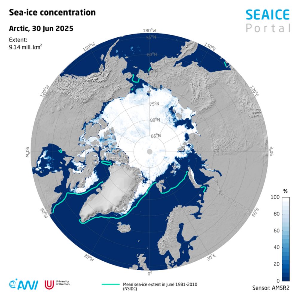
#Arctic sea ice is tracking 2012’s record lows-will the trend continue? In the #Antarctic, warm temps slow new-ice growth to near record-lows for June. Meanwhile, US restrictions on #satellite sea-ice data threaten vital climate time series. Find these news here: www.meereisportal.de/en/news-over...
21.07.2025 07:45 — 👍 1 🔁 1 💬 1 📌 0
✨ Professor Kathleen Stewart is kicking off her term as @ucgis.bsky.social president, leading the charge for next year’s national symposium at the University of Maryland!
Read more: geog.umd.edu/featured-con...
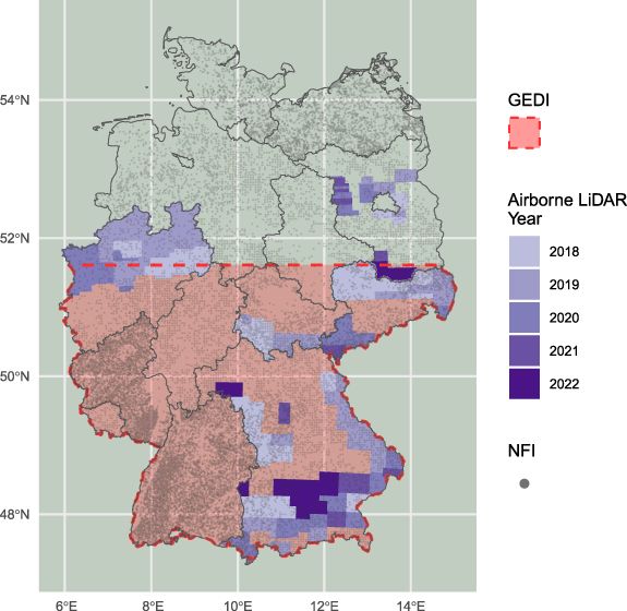
📗Read in #ERE how remote sensing can be utilised to map forest fuel across Germany, providing valuable data for regions at risk of wildfire 🛰️🔥🌳
Full article: iopscience.iop.org/article/10.1...
#environment #wildfire #ecology #openaccess #remotesensing #GEDI #LiDAR #forests #Germany #fuels #canopy
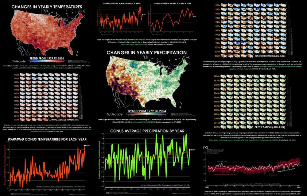
Screenshot showing a variability of different climate-related graphics for different United States climate change indicators
I'd like to introduce a new page on my website: U.S. climate indicator visuals (zacklabe.com/united-state...).
I only have a few basic variables so far, but I will be expanding this summer to add a range of metrics (e.g., ecological). I welcome suggestions! Hope this is useful, especially nowadays.