Front cover: A view of smoking volcanoes in East Java (Indonesia). In the valleys is a layer of Stratus, while on the top of Mount Semeru a small pyrocumulus (also known as flammagenitus) cloud can be seen. Volcanoes emit small particles into the air which provide additional surfaces onto which the water vapour can condense. Therefore, pyrocumulus clouds can appear more dense than other clouds. If the heat source is large enough, the pyrocumulus may evolve into a pyrocumulonimbus. (© Nur Syaireen Natasya Binti Azaharin: Smartphone Category Winner, Standard Chartered Weather Photographer of the Year 2024)
The June issue of @rmets.org Weather is online now! This is a Special Issue, with contributions from prize winners at last year’s Early Career and Student Conference.
Plus, all the main articles in this issue are fully Open Access ✅
Check it out now: rmets.onlinelibrary.wiley.com/toc/14778696...
03.06.2025 15:42 — 👍 18 🔁 4 💬 1 📌 0

Spot the sea breeze!
Pic from www.netweather.tv
19.05.2025 13:05 — 👍 2 🔁 0 💬 0 📌 0

The cloud has got its hat on today
21.04.2025 14:29 — 👍 18 🔁 2 💬 0 📌 1


Neat clouds from Bern, Switzerland. Lenticular (ish) and KH (ish).
03.04.2025 10:03 — 👍 3 🔁 0 💬 0 📌 0

Successful eclipse viewing with the Mark I Colander
29.03.2025 11:08 — 👍 15 🔁 2 💬 0 📌 0
Science in action
26.03.2025 17:58 — 👍 0 🔁 0 💬 0 📌 0
Undular bore clouds move over the Gulf south of Texas.
25.03.2025 19:30 — 👍 16 🔁 7 💬 1 📌 0
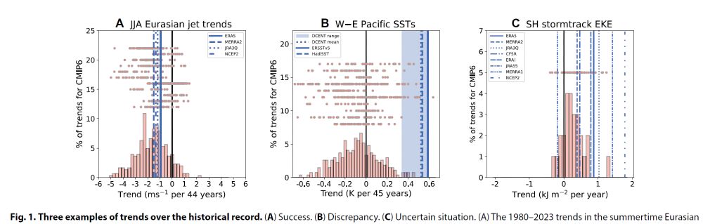
Can climate models reproduce observed trends?
The answer can be challenging. Our new review paper in Science Advances led by Isla Simpson and Tiffany Shaw @drshaw.bsky.social discusses challenges and ways forward in confronting climate models and observations.
www.science.org/doi/10.1126/...
13.03.2025 08:48 — 👍 105 🔁 44 💬 1 📌 6
Happy that our (@iccscambridge.bsky.social) JOSS paper on FTorch has been accepted and is now out. This is a really neat library, smoothly enabling coupling of ML models developed in PyTorch into Fortran code, now being used in various climate models (+ other scientific domains too). Well done team!
06.03.2025 14:31 — 👍 10 🔁 2 💬 0 📌 0

Moisture transport by convective overshoots in the tropical tropopause layer
Deep convection overshooting the tropical tropopause offers the potential for significant transport of moisture into the tropical tropopause layer (TTL) by avoiding the cold-point temperature constra....
The cold tropical tropopause limits water vapour concentrations in air that rises into the lower stratosphere. Strong, deep convection can avoid this constraint, injecting moisture that influences chemistry and radiative balance.
Read our review article in Weather here!
doi.org/10.1002/wea....
04.03.2025 20:36 — 👍 1 🔁 0 💬 0 📌 0
Great, thanks for the info! I'll keep my eyes peeled.
03.02.2025 10:19 — 👍 1 🔁 0 💬 0 📌 0
Has this subsumed the annual climate dynamics workshop? Haven't seen any info advertised for it yet.
03.02.2025 10:09 — 👍 0 🔁 0 💬 1 📌 0

Perfect day for some coaching
25.01.2025 20:08 — 👍 1 🔁 0 💬 1 📌 0
The extreme cyclone headed towards Ireland & the UK is a direct result of the upcoming southern US snowstorm - strong cold air advection into the Gulf of Mexico leads to an intense baroclinic wave developing and rapidly deepening as it traverses the North Atlantic:
21.01.2025 02:03 — 👍 71 🔁 11 💬 3 📌 3

A map from the GFS weather model showing MSLP and jet stream strength at 00:00 UTC on Sunday 26 January 2025 across the North Atlantic. Three areas of low pressure (a cyclone family) can be seen simultaneously at various phases of their development.
A jet-stream fired up by the current North American coldwave will lead to a phenomenon known as a "Cyclone Family" in the North Atlantic.
Multiple deep low pressure areas develop and take a similar track late January (close to the British Isles)
More info: www.nature.com/articles/s41...
20.01.2025 21:07 — 👍 32 🔁 10 💬 5 📌 0

The potential is there for a very nasty storm for NW Ireland on Friday morning depending on the placement of the depression. UKV is particularly concerning showing gusts in excess of 100 mph (160 km/h) for exposed NW coasts.
20.01.2025 21:18 — 👍 10 🔁 1 💬 1 📌 1

Bar graph showing global ocean heat content change in the upper 2000 m from the late 1950s through 2024. There is a long-term warming in the time series.
ICYMI - 2024 was also the hottest year on record for our oceans. Unfortunately, we now say this every year. 🥹🌊
+ Data: www.ocean.iap.ac.cn
+ Study: doi.org/10.1007/s003...
+ Summary: www.carbonbrief.org/state-of-the...
18.01.2025 21:53 — 👍 339 🔁 165 💬 12 📌 11

Finalising some figures of an idealised deep convective cloud top. Reassuring when simulations resemble observations!
18.01.2025 21:37 — 👍 2 🔁 0 💬 0 📌 0

Ice crystals are beautiful!
11.01.2025 21:39 — 👍 0 🔁 0 💬 0 📌 0

Hurricane Season 2024 retrospective | Inigo
by Charles Powell (University of Cambridge) and Ruth Petrie (Inigo) Key points Forecasts for the season Coming into the 2024 hurricane season, almost all forecasts pointed towards an above average sea...
Working with the climate science team at Inigo insurance, I've written a retrospective on the 2024 hurricane season. We look at why forecasts predicted such an active season, why activity died down during the climatological peak, and what we might expect in the future.
Check it out here!
05.12.2024 10:08 — 👍 5 🔁 2 💬 1 📌 0

Award details | Funding and scholarships for students | University of Exeter
Having had the pleasure to work on this fascinating project with the potential for big impacts across the globe, please do share far and wide with anyone interested in a cutting-edge PhD opportunity in lovely to develop a brand new source of atmospheric observations!
www.exeter.ac.uk/study/fundin...
25.11.2024 12:12 — 👍 1 🔁 1 💬 0 📌 0

At this time of year, it’s hard not to go slightly blind when taking cool cloud photos…
13.11.2024 22:52 — 👍 0 🔁 0 💬 0 📌 0
Our results highlight the difficulty in resolving and parameterising convection in climate models. The mixing statistics are time sensitive and localised, so high temporal and spatial resolution is needed to capture the mixing.
17.10.2024 13:01 — 👍 4 🔁 0 💬 1 📌 0

We also looked at metrics that quantify mixing. We identified a three-stage mixing process, each with distinct characteristics. It turns out the most efficient mixing occurs in a thin layer at the top of the plume.
17.10.2024 13:00 — 👍 0 🔁 0 💬 1 📌 0

To understand turbulent transport and mixing, we use a phase space where the fluid buoyancy and tracer concentration are the coordinates.
It turns out the mixing is much clearer in this space and clarifies the mixing process between plume and environmental fluid.
17.10.2024 13:00 — 👍 0 🔁 0 💬 1 📌 0

Diagnosing tracer transport in convective penetration of a stably stratified layer | Journal of Fluid Mechanics | Cambridge Core
Diagnosing tracer transport in convective penetration of a stably stratified layer - Volume 997
My first PhD publication has just been released!
doi.org/10.1017/jfm....
We consider a buoyant plume with a passive tracer penetrating into a stably stratified layer. This idealised flow is representative of many geophysical flows, for example tropical deep convection.
🧵⬇️
17.10.2024 12:59 — 👍 13 🔁 0 💬 1 📌 0

Shelf cloud over the Centre for Mathematical Sciences in Cambridge earlier today
12.09.2024 19:25 — 👍 1 🔁 0 💬 0 📌 0

Hints of mammatus?
11.09.2024 14:09 — 👍 1 🔁 0 💬 0 📌 0
Official account for the University of Cambridge. Follow us for research, news, events and student stories from the Cambridge community 🎓📚
Stratospheric research at UCam. Side interest in mycology. Views my own. https://thestratosphere.co.uk/
We support and empower climate scientists by accelerating their research through the development of innovative tools and models in computational science, data science and machine learning.
https://iccs.cam.ac.uk/
Scientist (mainly of atmospheres and oceans of Earth and other planets), and an occasional poster.
Making software more open, explorable and self-explanatory
https://dynamicaspects.org/research
Also: subjectivity, agency, active inference, niche construction, enactivism
@plrg-bristol.bsky.social
@iccscambridge.bsky.social
@f.luid.org
Toward a Climate-Smart Nation. The official NOAA account for Climate.gov hosted by the Climate Program Office. Follow for #climate news, #science, #data, resources, and more!
Official Bluesky account for NOAA's National Weather Service.
NOAA provides science, service and stewardship to protect life, property & Earth's natural resources. An agency of the Department of Commerce. Join us on Instagram & Facebook. Official NOAA account.
Univ. of Manchester Prof of Synoptic Meteorology, educator, scientist
Author: Eloquent Science: A Practical Guide to Becoming a Better Writer, Speaker, and Atmospheric Scientist
Free online climate course: "Our Earth: Its Climate, History, and Processes"
Senior Research Fellow @ Uni of Reading Meteorology & NCAS | Sting jets💨 Cyclones (Arctic, Extratropical, Mediterranean....) 🌀 Alps🏔 Monsoons⛈️| Cycling,hiking & views all my own| Catholic, husband, dad, son
fluid dynamicist interested in waves/instabilities/turbulence in stratified flows
Lecturer in Applied & Computational Maths @ UCD
Turbulence | Phase change | Environmental Flows | Numerical Methods
Professor of ship hydrodynamics at TU Delft. I study flow physics, direct and data-driven modelling, & shape-changing vehicles. 🌊⛵ + 💻📈 + 🦑🤖
Postdoc at UC Berkeley working on the fluid dynamics of ocean mixing 🌊
Biostatistics PhD Student @MRC BSU @University of Cambridge
Professor of Planetary Computing at the University of Cambridge @cst.cam.ac.uk, where I co-lead the @eeg.cl.cam.ac.uk and work on computing for global biodiversity and climate change with @conservation.cam.ac.uk.
Homepage at https://anil.recoil.org
Computer science academic, co-directing the Institute of Computing for Climate Science at the University of Cambridge and a senior lecturer in computer science at the University of Kent. Programming languages >< climate modelling
https://dorchard.github.io