Nova Scotia Outages Update:
6:00PM AST
⚡Grid Outages: 13 (+2)
📍People Affected: 244 (+109)
(+/- indicates change from previous hour.)
#NSStorm #NSwx
01.02.2026 22:12 — 👍 0 🔁 0 💬 0 📌 0
Nova Scotia Outages Update:
5:00PM AST
⚡Grid Outages: 11 (+8)
📍People Affected: 135 (+123)
(+/- indicates change from previous hour.)
#NSStorm #NSwx
01.02.2026 21:27 — 👍 1 🔁 0 💬 0 📌 0


A tornado watch has been issued for #Fredericton and southern York County. Conditions are favourable for the development of severe thunderstorms that could produce a tornado. A strong cell to the northeast of Lincoln, Maine is expected in the area within an hour. #NBStorm
07.07.2025 20:24 — 👍 2 🔁 0 💬 0 📌 0

Provincial highs today as of 3:30PM:
Jimtown: 31.2°C
Cape Dauphin: 31.2°C
Monastery: 31.1°C
Tarbotvale: 30.7°C
Ingonish: 30.6°C
Roberta: 30.6°C
Antigonish: 30.4°C
Lakevale: 30.4°C
Glace Bay: 30.4°C
Ingonish Harbour: 30.4°C
Kings Point: 30.3°C
Glen Tosh: 30.2°C
Sydney Mines: 30.0°C
#NSStorm #NSwx
02.07.2025 18:38 — 👍 0 🔁 0 💬 0 📌 0

A heat warning is in effect across the Valley which includes Annapolis, Kings & Hants counties. Temperatures over 29°C are expected over the next two days combined with humidex values over 36°C. #NSStorm #NSwx
01.07.2025 13:43 — 👍 0 🔁 0 💬 0 📌 0

Projected rainfall accumulation has not changed much since yesterday, although confidence in some higher patches of 30-40mm along the immediate southern shore has increased. Stay cautious when driving in any heavier downpours that may develop. #NSStorm
28.06.2025 14:11 — 👍 0 🔁 0 💬 0 📌 0

Some moderate rainfall has pushed its way into western Nova Scotia and is now reaching #Halifax a little earlier than anticipated. Rain will continue to push east into the rest of the mainland throughout the day and there is a risk of embedded thundershowers later on. #NSStorm
28.06.2025 14:09 — 👍 2 🔁 0 💬 1 📌 0
Typically we wouldn't delve too far into a system like this unless there was an active lightning and/or flood threat, but we've noticed some unrest being spread in regard to it and wanted to ease some nerves. Regardless, we will update you if anything changes.
28.06.2025 02:31 — 👍 0 🔁 0 💬 0 📌 0
The vast majority of the heaviest rains & embedded thundershowers will remain relatively far to the south of the area. Things could change over the next 12 hours or so, but that would only really mean some additional totals along the south shore, not too unusual. #NSStorm #NSwx
28.06.2025 02:31 — 👍 0 🔁 0 💬 1 📌 0

A minor system will cross just to the south of the region beginning late tomorrow and into the overnight hours, potentially leading to localized gusty winds and pockets of 20-30mm of rainfall, perhaps slightly more in areas where thundershowers develop. #NSStorm #NBStorm
28.06.2025 02:21 — 👍 2 🔁 0 💬 1 📌 0

An extremely rare 30° day in Yarmouth, Nova Scotia today!
This is just the 6th time the town has hit 30° since 1871 (154 years).
Today's 30.4° is the first time to reach the mark in the month of June.
The other 5 occurrences were in July (1911, 1968, 1977, 1993 & 2013)
#nswx #halisky
25.06.2025 21:30 — 👍 21 🔁 3 💬 1 📌 3

Large cluster of severe thunderstorms located to the north of #Moncton are headed south-southeastwards into the town and the rest of southeastern New Brunswick. #NBStorm
24.06.2025 22:36 — 👍 2 🔁 0 💬 0 📌 0
Cape Breton Mesonet (Live)
*Several stations have tied for the top five spots. This is preliminary data and comes from capebretonweather.ca
24.06.2025 19:03 — 👍 0 🔁 0 💬 0 📌 0
Top 5 highest recorded temperatures in Nova Scotia as of 4PM:
#1: Windsor: 35.3°C
#1: Upper Falmouth: 35.3°C
#2: Bridgewater: 34.2°C
#2: Upper Northfield: 34.2°C
#3: West Caledonia: 33.9°C
#4: Hillaton: 33.7°C
#4: Pleasant River: 33.7°C
#5: Brooklyn Corner: 33.5°C
#NSStorm #NSwx
24.06.2025 19:02 — 👍 4 🔁 0 💬 1 📌 0

Healthy thunderstorm cells are beginning to develop in eastern New Brunswick to the north of #Moncton. They are headed relatively southeastwards towards #Shediac and #Amherst. #NBStorm #NSStorm
24.06.2025 18:53 — 👍 0 🔁 0 💬 0 📌 0

With a temperature of 34.8°C and a humidity value of 60%, #Windsor has hit a dangerously high humidex value of 48°C. Similar values are being recorded in #Falmouth, where the humidex sits at 46°C. Try to avoid spending too much time outdoors! #NSStotm #NSwx
24.06.2025 17:48 — 👍 0 🔁 0 💬 0 📌 0

Many stations closing in on the mid 30s before 3pm... Windsor and surrounding areas take the top spot right now at 35°C! With a couple more hours of heating to go in one of the longest days of the year it looks very likely many records will get broken today. #NSStorm #NSwx
24.06.2025 17:45 — 👍 3 🔁 4 💬 2 📌 0

Widespread values of 30°C and higher are being reported across Nova Scotia early this afternoon. Temperatures will continue to rise and peak around 3-4pm likely nearing or reaching 35°C for some areas, which will feel more like 40-45 with the humidex. Stay hydrated! #NSStorm
24.06.2025 16:21 — 👍 3 🔁 0 💬 0 📌 0

A line of thundershowers is making its way across Richmond county this morning. St. Peter's and surrounding areas currently being impacted. #NSStorm
24.06.2025 13:15 — 👍 2 🔁 0 💬 0 📌 0


A heat warning is now in effect across much of mainland Nova Scotia for today and tomorrow. #NSStorm
24.06.2025 12:20 — 👍 0 🔁 0 💬 0 📌 0


Plenty of heat across the province this afternoon, with much of the Valley and especially the Cape Breton highlands hitting the 30°C mark. Ironically, "Smelt" Brook has seen the hottest recorded temperature so far today at 34.8°C! #NSStorm #NSwx
20.06.2025 18:37 — 👍 3 🔁 0 💬 0 📌 0

It's hot in the highlands today. Temperature values of up to or over 32°C are being recorded on both coasts at noon, and combined with humidity levels well over 60% in some spots it's feeling more like 40°C! #NSStorm #NSwx
20.06.2025 15:30 — 👍 2 🔁 0 💬 0 📌 0
Gust of 153km/h! I looked at the Confederation Bridge camera: at 3:04pm, it was nasty on the bridge! Later you see motorcycles, high sided vehicles and travel trailers crossing. Indeed a severe thunderstorm! www.youtube.com/watch?embeds...
12.06.2025 20:01 — 👍 28 🔁 4 💬 1 📌 1

A severe thunderstorm warning has been issued for southern Inverness County. A powerful cluster of thunderstorms have formed over southwestern Cape Breton and are headed due northeast. #NSStorm #NSwx
12.06.2025 19:35 — 👍 1 🔁 0 💬 1 📌 0
Thunderstorms continue to track across the Maritimes this afternoon. Severe thunderstorm watches have been expanded to all of northern Nova Scotia and a warning is in effect tor Queens County, PEI. #NSStorm #PEStorm
12.06.2025 18:36 — 👍 0 🔁 0 💬 0 📌 0

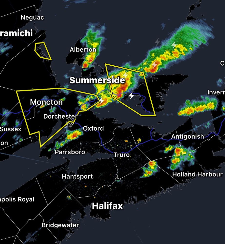
A line of strong thunderstorms has formed stretching from #Moncton, NB to #Summerside, PEI. Severe thunderstorm warnings are in effect across the area for frequent lightning, torrential downpours and potentially nickel sized hail. #NBStorm #PEStorm
12.06.2025 17:38 — 👍 0 🔁 0 💬 0 📌 0


A severe thunderstorm watch has been issued for Colchester County south of Truro and Pictou County. Thunderstorms have begun forming across areas of northern and central Nova Scotia at this hour. #NSStorm
12.06.2025 17:33 — 👍 0 🔁 0 💬 0 📌 0

The severe thunderstorm warning has been extended up the coast of eastern New Brunswick stretching from Cape Tormentine to Escumniac. #NBStorm
12.06.2025 17:20 — 👍 1 🔁 0 💬 0 📌 0


A severe thunderstorm warning has been issued for Moncton and surrounding areas. A line of strong thunderstorms are making their way east-southeast through the region. #NBStorm #PEStorm
12.06.2025 17:16 — 👍 1 🔁 1 💬 0 📌 0
This watch has been upgraded to a warning. #PEStorm
12.06.2025 16:59 — 👍 1 🔁 0 💬 0 📌 0