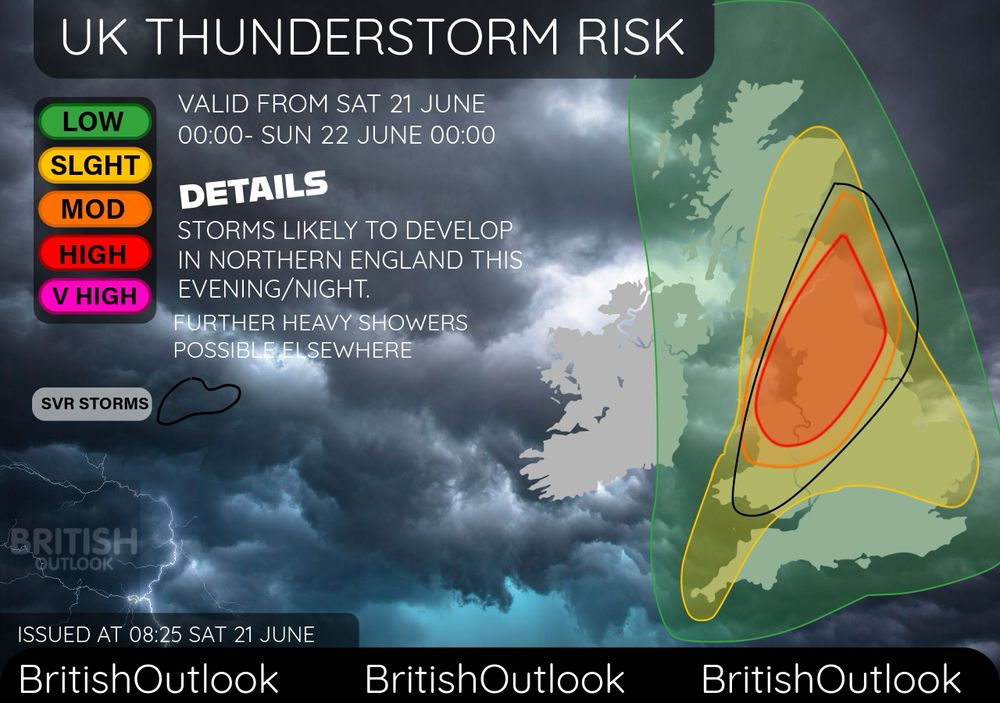
UK THINDERSTORM RISK•
•VALID FROM NOW-00:00 SUNDAY 22 JUNE•
Thunderstorms are likely to develop in N England today, Further storms possible elsewhere such as Wales, Norfolk, Midlands, Cornwall and pretty much anywhere.
#weatheruk #thunderstorms
21.06.2025 08:43 — 👍 9 🔁 0 💬 0 📌 0
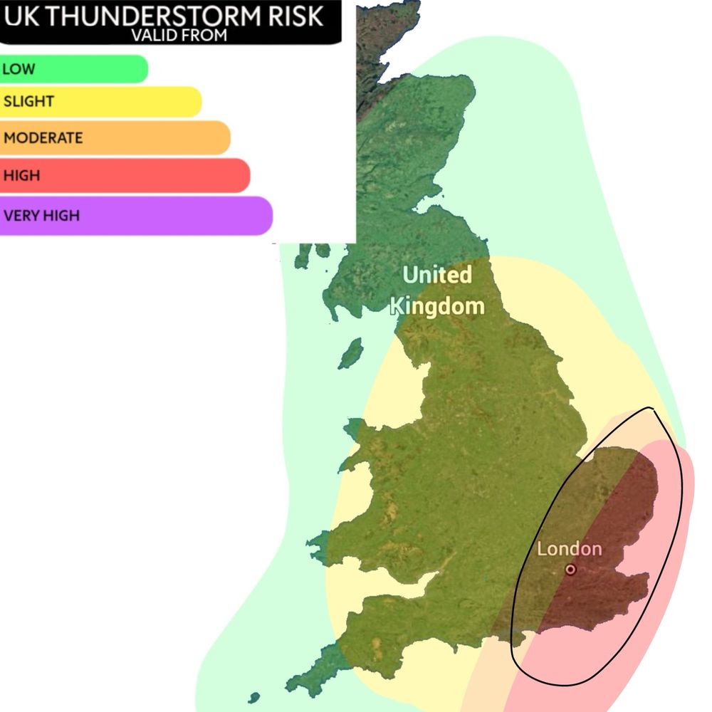
UK THUNDERSTORM RISK 13/14JUNE 2025
An Amber warning has been issued in SE England tonight from 8pm to 5am tomorrow morning. Some disruption is likely within this area, with flooding likely, power cuts and potential damage to buildings.
13.06.2025 11:25 — 👍 5 🔁 1 💬 0 📌 0
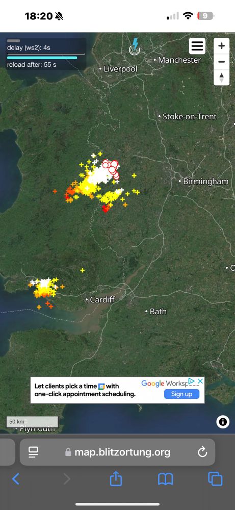
Some thunderstorms developing in Wales currently, along with some in NE England.
01.05.2025 17:21 — 👍 11 🔁 0 💬 0 📌 0
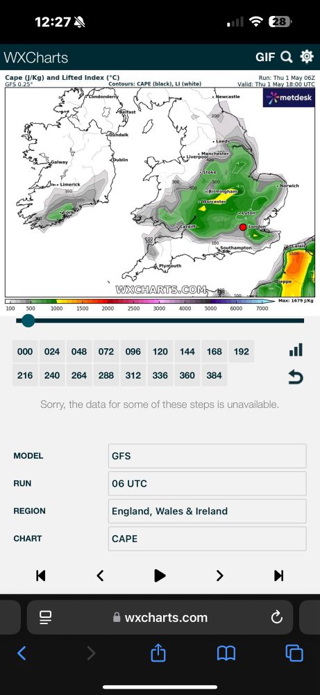
Along with the high temperatures today, some thunderstorms are likely to develop.
30°c possible in London, temperatures will likely significantly drop to more near average after the next couple days.
01.05.2025 11:29 — 👍 5 🔁 0 💬 0 📌 0
Yes and this is a weather account sharing updates, temperatures will be below average for the time of year and I’m posting updates about that
03.02.2025 14:04 — 👍 3 🔁 0 💬 0 📌 0
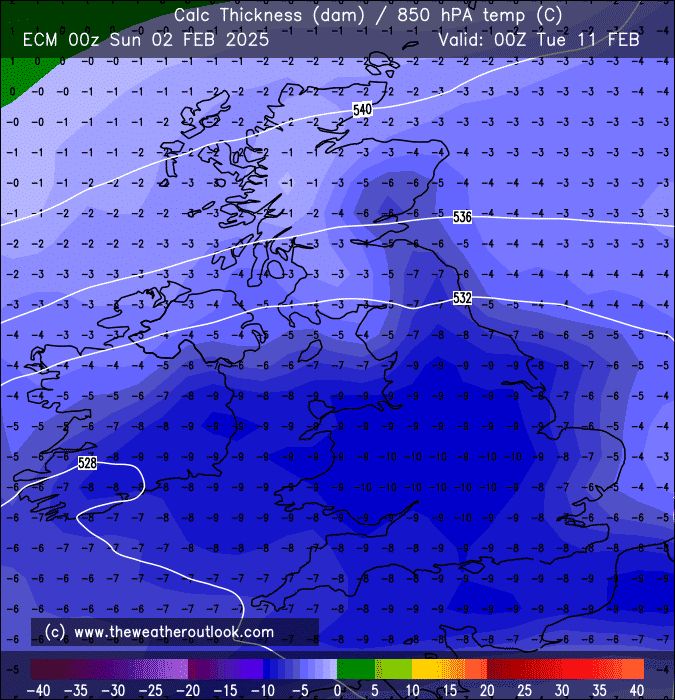
ECM showing widespread -10°c 850hPa temperatures Tuesday 11 Feb, obviously certainly cold enough for snow.. this is still over a week away so changes are certain, but cold weather is increasing likely ❄️
02.02.2025 08:32 — 👍 20 🔁 1 💬 2 📌 1
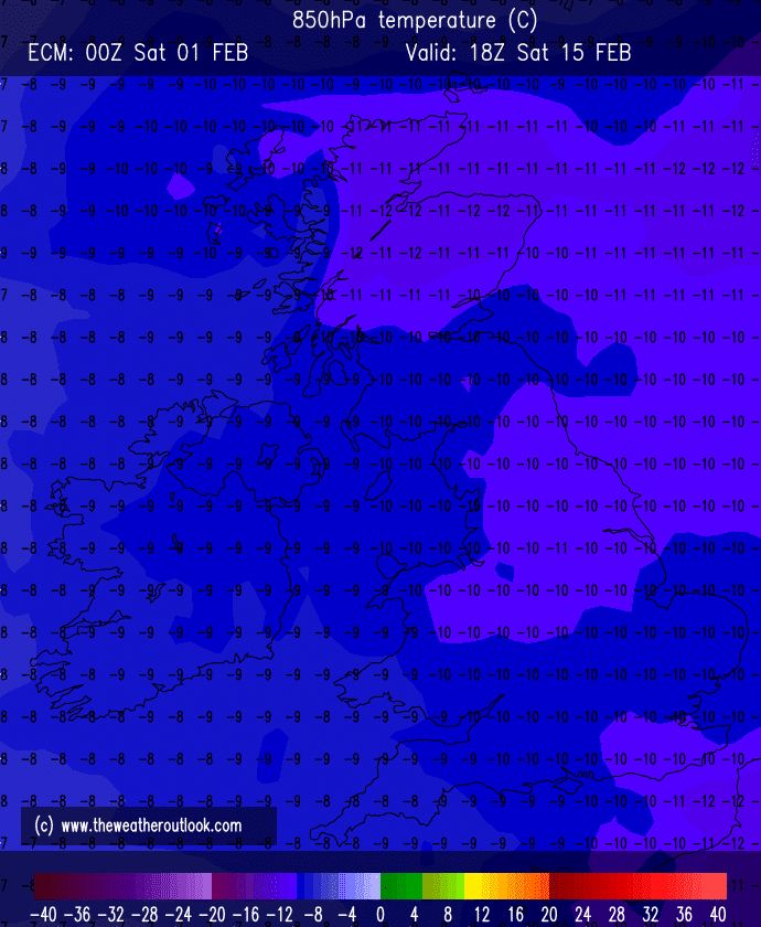
ECM showing -12°c 850hPa temperatures Friday 14th feb, with -10°c widespread, obviously this is 2 weeks away but certainly cold enough for snow if this verified ❄️
#uksnow
01.02.2025 09:43 — 👍 11 🔁 1 💬 0 📌 1
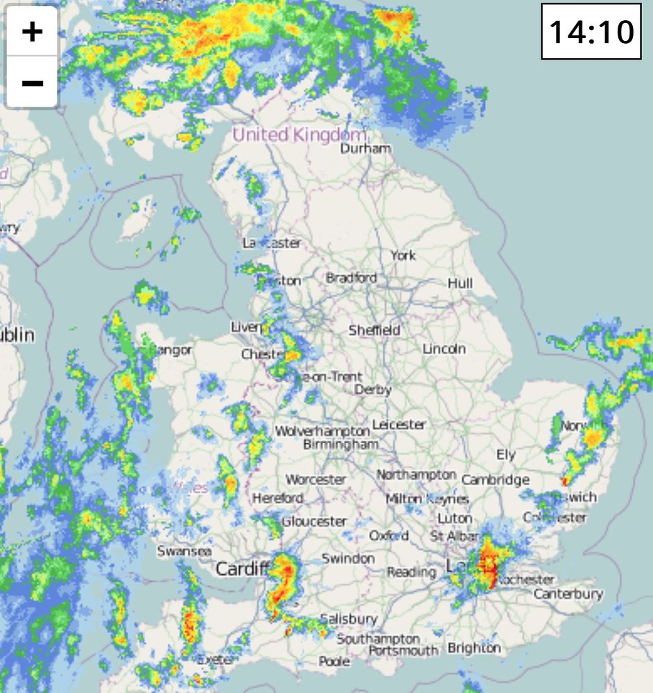
Some heavy rain for some today, a heavy thunderstorm currently affecting London producing lots of lightning ⛈️
Make sure to post any pictures
27.01.2025 14:18 — 👍 7 🔁 0 💬 0 📌 0
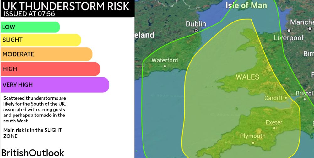
UK THUNDERSTORM RISK
Scattered thunderstorms along with strong gusts are likely in the South and parts of E Ireland, particularly late morning-afternoon
A tornado possible in the SW
#thunderstorm
26.01.2025 09:47 — 👍 10 🔁 0 💬 0 📌 0
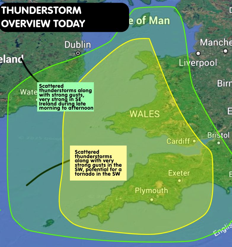
THUNDERSTORM OVERVIEW TODAY
Issued at 07:56 26th Jan 2025
Scattered thunderstorms will be associated with strong gusts for many in the South, there will be a small risk of a tornado in the SW and some small hail possible
26.01.2025 08:03 — 👍 7 🔁 1 💬 0 📌 0
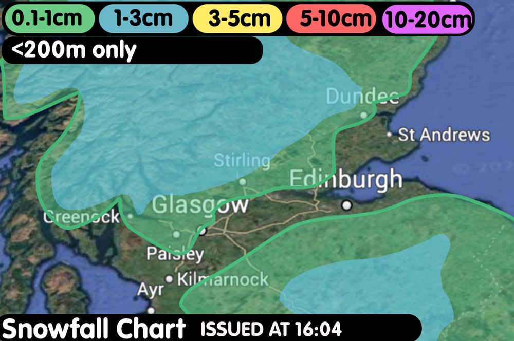
SNOWFALL CHART SCOTLAND <200M
Small accumulations possible widespread throughout this evening, perhaps quite a few cm locally, especially over higher elevations
Glasgow will have a mix of rain/snow/sleet, temporary accumulations possible in this area
#snow
25.01.2025 17:18 — 👍 7 🔁 0 💬 0 📌 0
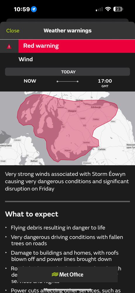
RED WARNING IN FORCE ‼️
The Red wind warning for Scotland is now in force, 80-90mph gusts for many with up to 100mph possible
Make sure to take caution and listen to the Met Office’s advice.
#weather #stormeowyn
24.01.2025 11:00 — 👍 8 🔁 0 💬 0 📌 1
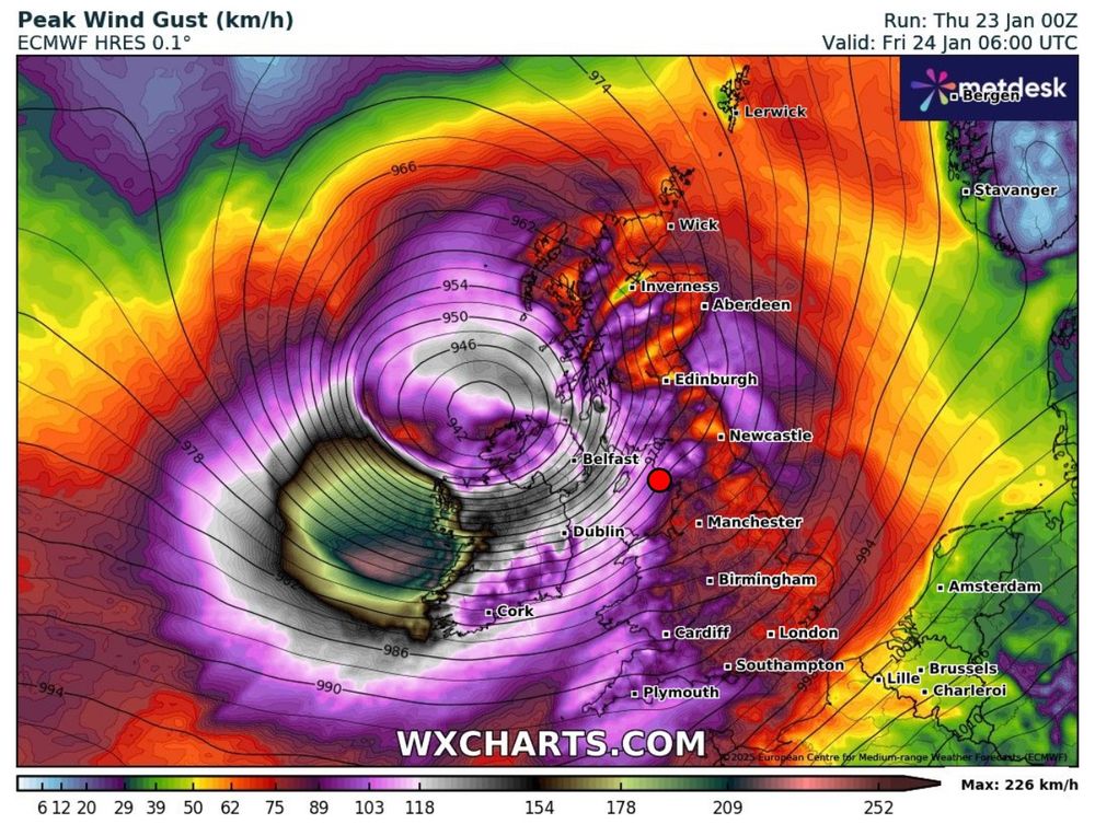
#storméowyn is looking VERY serious for western Ireland, please take action now if you’re within the red warnings issued by the MO and Met Éireann
#stormeowyn
23.01.2025 16:53 — 👍 18 🔁 4 💬 0 📌 0
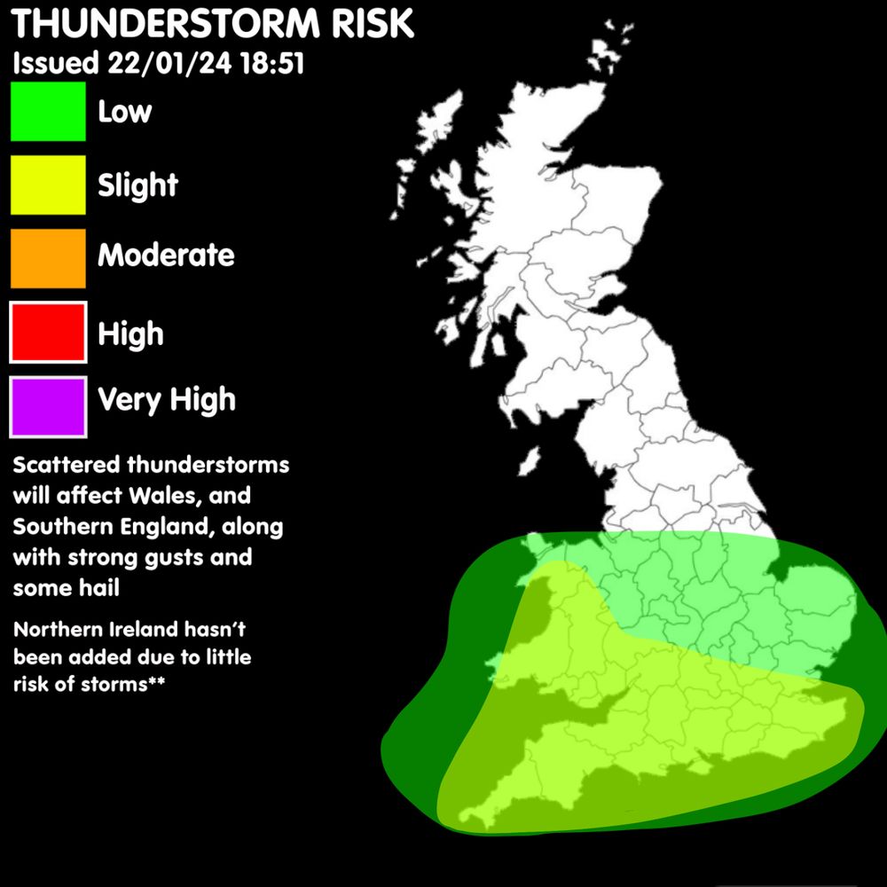
Thunderstorm Risk Today
VALID FROM NOW-00:00 FRI
Scattered thunderstorms affecting Wales and Southern England, along with gusty winds, some hail possible.
A wind outlook will be issued later as severe winds are likely..
23.01.2025 06:51 — 👍 12 🔁 3 💬 1 📌 0
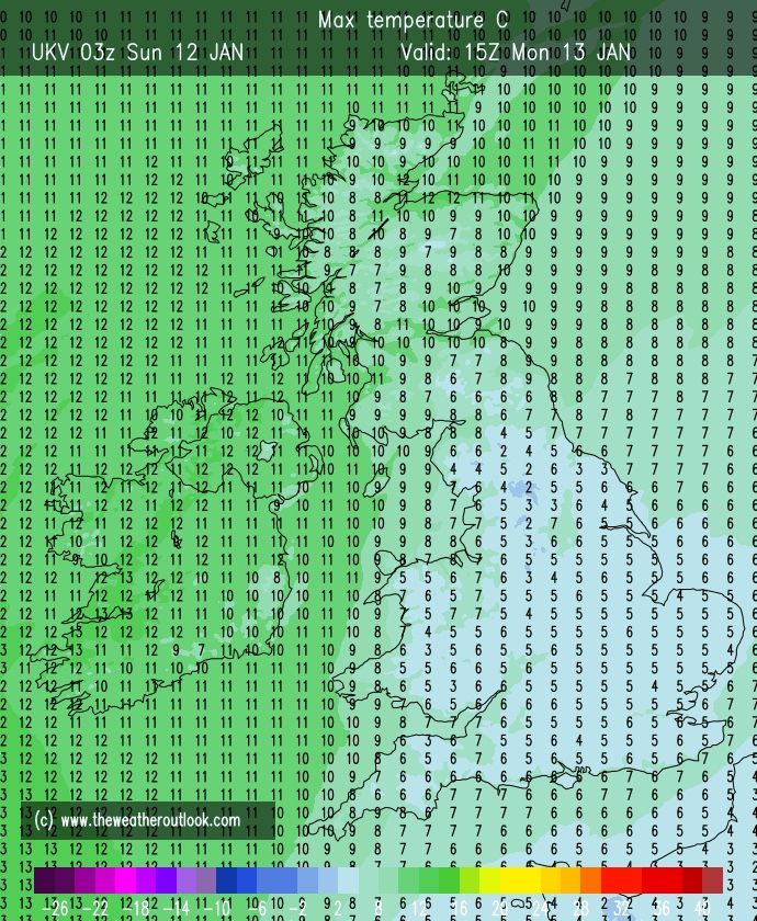
Tomorrows max temperatures 🌡️
Increase in temperature for many, especially in Scotland. Still remaining chilly for many
**Based from UKV model**
Max of 10oc in England
Max of 10oc Wales
Max of 13oc Scotland
Max of 13oc Northern Ireland
12.01.2025 15:01 — 👍 13 🔁 0 💬 0 📌 1
Hope you’re enjoying it ❄️
11.01.2025 15:28 — 👍 1 🔁 0 💬 0 📌 0
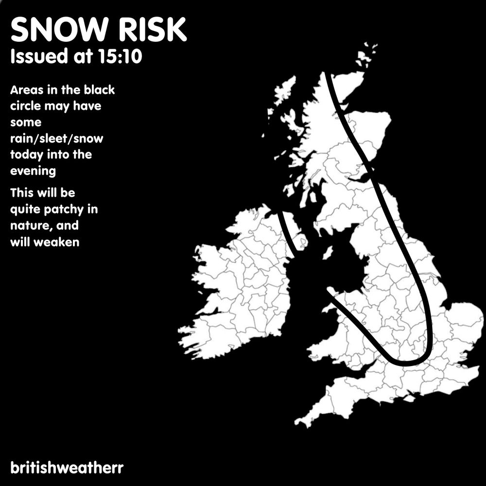
Areas in the black circle may have some rain/sleet/snow today into the evening
11.01.2025 15:12 — 👍 10 🔁 0 💬 0 📌 0
It was because there wasn’t a risk there, so I only wanted to added areas with the risk
11.01.2025 15:03 — 👍 1 🔁 0 💬 0 📌 0
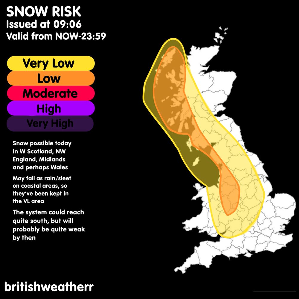
SNOW RISK TODAY UK ❄️
Widespread very low risk of snow, with a high-end low risk affecting W Scotland, NW England.
Potential for a moderate to be issued later if the chances increase
#uksnow
11.01.2025 09:53 — 👍 8 🔁 0 💬 2 📌 0
Jeez 😳😳
10.01.2025 17:33 — 👍 0 🔁 0 💬 0 📌 0
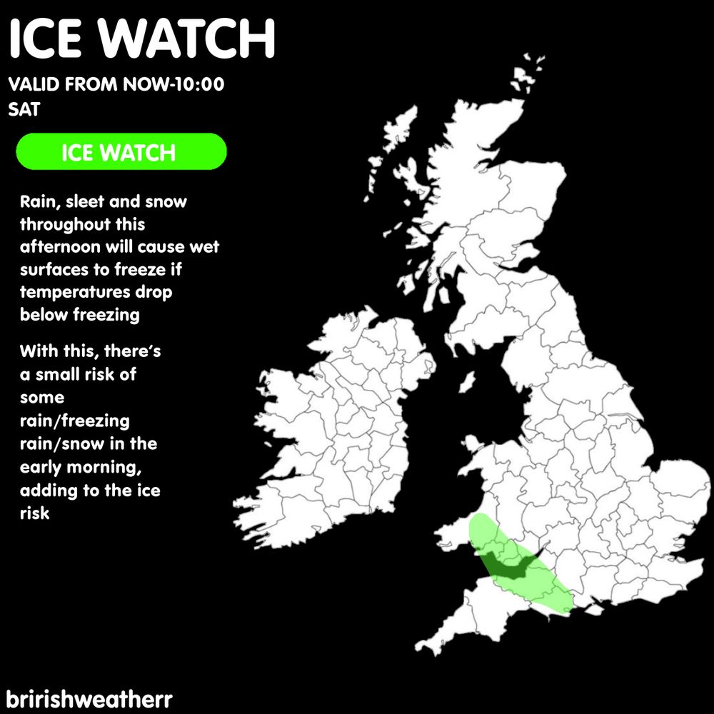
ICE WATCH ⚠️
Rain/snow in the south today will freeze overnight in places where temperatures are below freezing.
Small chance of some more rain or wintry weather in the morning but it will fizzle out without any significant impacts.
#uksnow
10.01.2025 13:54 — 👍 5 🔁 0 💬 1 📌 0
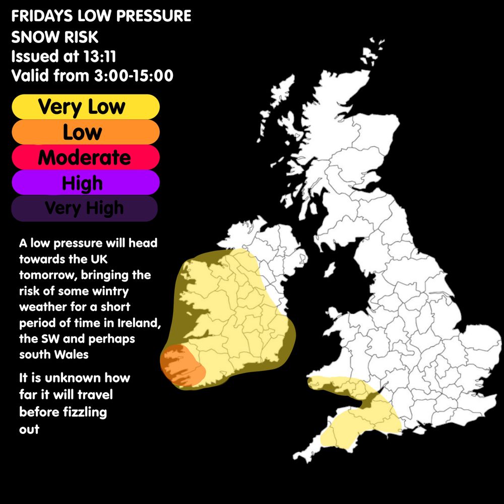
Snow Risk Tomorrow ❄️🌨️
Very low risk of snowfall in the SW, sWales, and Ireland.
Low risk of snowfall south of Ireland
It reminds uncertain how far the snow will get before fizzling out
#uksnow
09.01.2025 13:39 — 👍 5 🔁 0 💬 0 📌 0
I actually was about to issue one for the snow showers currently there, just didn’t have enough room to add all the different warnings with the text as there’s a text limit
09.01.2025 07:36 — 👍 1 🔁 0 💬 0 📌 0
This graphic was for the low affecting the south today
08.01.2025 12:04 — 👍 1 🔁 0 💬 0 📌 0
Why? 🤔🤷
08.01.2025 10:32 — 👍 0 🔁 0 💬 1 📌 0
There has been a north shift on a lot of the models, bringing the snow risk further north ❄️
08.01.2025 05:23 — 👍 1 🔁 0 💬 0 📌 0
Yep, it’s still uncertain on where, snow could be as south as south wales but probably not warning worthy
08.01.2025 05:19 — 👍 0 🔁 0 💬 0 📌 0
Omg😂😂
08.01.2025 05:18 — 👍 1 🔁 0 💬 0 📌 0
😂
07.01.2025 14:26 — 👍 0 🔁 0 💬 0 📌 0
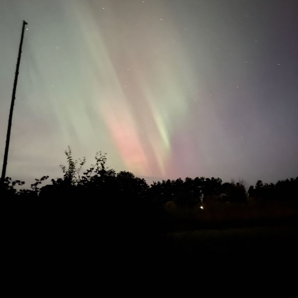
🌈Nature and travel photography 📸
All photos are mine.
One will fall to bottle
One will fall to the spike
One will fall to the devil
One will fall out of spite
Love Auroras, the moon, cats, rocks, books, crystals, chocolate, tea and coffee. And plants. And fungi! Paramedic/Instuctor, manic gardener, worked for the Blue side, Canadian/French/Scottish/Irish heritage
I'm a Kinky Fecker ie I'm a Switch , pro 420 & Progressive for the 21st Century & believe in Green Policies , ie I'm a Fecking Egalitarian & an Irish Republican ¡¡
Retired USDA. Blue: through and through. Raised in MA, educated in WI (Madison) and reside in the Blue Ridge Mtns of VA🖖
I’m the village idiom. Full supporter of all civil rights: LGBTQ+, women, minorities, et al. 2nd wave feminist: end the patriarchy. Poetry writer, music producer.
https://www.mcsweeneys.net/articles/frequently-asked-questions-at-the-office
✅Pro-peace
✅Democracy defender
✅CALL CONGRESS https://5calls.org/
✅EMAIL CONGRESS https://resist.bot/
🇺🇸🇨🇦🇬🇱🇵🇦🏳️🌈🏳️⚧️🇪🇺🇺🇦
#WOKE #vegan #environment 🏳️⚧️ #Palestine, NVDA, nature, cats,
#knitting , art, theatre, philosophy, urban living, yoga, gardening. Car free cyclist. I go on lots of protests. I mean a lot. ✊🏾🇵🇸
#LadySlipperHERE 🇨🇦 #OrchidS
#PHOTOGRAPHY #PHOTOsky 🦋
#LoudORCHID 😱 #OrchiD #FLoWerS
•
I make & #repost #Memes #Meme
& tend 2 post #Photographers
*Morph #Avatars or handles sometimes🏴☠️🚩
•
Award-winning #FLOWER #Photographer
>•I support #ORCAS & TheARTS•<
Counsellor, bass clarinet playing Gen X snowflake diagonally parked in a parallel universe.
Scottish Independence, Green, Twitter refugee.
No DMs
#FBPE #RejoinEU #Wulferhampton
Freelance science and technology journalist. 11+ years experience. Irish/Polish. I write for the BBC, Wired, the BMJ, The Guardian, and others!
Newsletter: thereengineer.pro
Portfolio: chrisbaraniuk.com
HQ: Belfast, Northern Ireland
Trans-inclusive academic by day
Fangirl by night
she/they
🏳️🌈🏳️⚧️🩸🦇🔪
Thesis: https://orca.cardiff.ac.uk/id/eprint/176096/