Themed versions of old fashioned strip maps. Nice!
30.11.2025 19:47 — 👍 1 🔁 0 💬 0 📌 0
I was surprised at the number of fellow #sussexmappers on Bluesky who share an obvious interest in my home county: Sussex. Please don't stop sharing just because the challenge is over for another year. Well done to all who participated in this year's #30daymapchallenge.
30.11.2025 10:43 — 👍 2 🔁 0 💬 0 📌 1
I'd like to thank those who liked and commented on my maps. I am in awe of those who work with GIS tools regularly to produce the stunning works I've seen on display - I will be revisiting some of those over the next month.
30.11.2025 10:41 — 👍 1 🔁 0 💬 1 📌 0
I've had two attempts to complete the #30daymapchallenge since I took up making maps as a hobby during the pandemic. I've never really come close. I took three years off (helpful: to bank a few maps) and for the rest: some determined time planning needed. I'm very happy to have made it to day 30.
30.11.2025 10:40 — 👍 1 🔁 0 💬 1 📌 0

#30daymapchallenge Day 30: Makeover. A deeper look at one area of my Day 16, Sediment Cell Map - at a national level. The movement, processes and materials that are endlessly occurring on my local beach. Before I made this map I was curious - now I know!
30.11.2025 10:38 — 👍 2 🔁 1 💬 1 📌 0

#30daymapchallenge Day 29: Raster. Lake Bosumtwi. Not the first time I've mapped this asteroid crater lake in Ghana - I'm still fascinated by its half spherical shape.
29.11.2025 09:09 — 👍 4 🔁 0 💬 0 📌 0
😄 I didn't think of that. I did think about Gulf of M***** and New M***** instead. The A****** gave me more to redact. It also made me realise that, just maybe, you can get greedy when claiming a name.
28.11.2025 08:57 — 👍 1 🔁 0 💬 0 📌 0

#30daymapchallenge Day 28: Black. All The *******. A had the idea of redacting a map somehow. This is what I came up with.
28.11.2025 07:49 — 👍 4 🔁 0 💬 1 📌 0

A map of Sussex and surrounding counties showing historic borders. The map is juxtaposed with a clip from Yeakell and Gardner's 1797 map of the county that shows two enclaves. Bohunt part of Sussex now in Hampshire and the Tithing of Ambersham which was part of Hampshire but in the middle of what is now West Sussex on the Surrey border. The text on the map states that both enclaves were removed under the Counties (Detached Parts) Act of 1844.
#30daymapchallenge Day 27: Boundaries. I was lucky enough to find a mid 19th century copy of Yeakell and Gardner's historic map of Sussex (1799) a couple of months ago. I noticed a couple of weird borders - now gone. Here they are on a modern map.
27.11.2025 07:49 — 👍 4 🔁 1 💬 0 📌 0

A map showing the African coastline between Mauritania and Cameroon. The coast is styled to highlight a strip of land showing all of the ports between Nouabhidouh and Kribi.
#30daymapchallenge Day 26: Transport. A map of West African Ports - in terms of the region this may appear to be an eclectic selection - but it is where my day job happens to be.
26.11.2025 08:10 — 👍 2 🔁 0 💬 0 📌 0

A hex map of Great Britain showing the density of trig points across the country. The densities run from 0 to 154 per 10km hex bin. The densest areas are urban.
#30daymapchallenge Day 25: Hexagons. Revisiting my Day 1 dataset - the OS trig point database. Point density again shows a concentration in urban areas.
25.11.2025 07:01 — 👍 5 🔁 0 💬 0 📌 0

A map showing a hillshade of the South Downs around the Adur and Ouse rivers. The features of the map are 'Bostals' - a word in Sussex Dialect - that means a steep road or path, usually up the face of the Northern escarpment of the Downs.
#30daymapchallenge Day 24: Places and their names. 'Bostals'. This map shows the steep roads and paths known as Bostals in Sussex Dialect. Sussex Dialect is also notable for having >30 words for mud - some of which remain in use in modern English. "We wunt be druv!"
24.11.2025 07:48 — 👍 3 🔁 0 💬 0 📌 1
👍
23.11.2025 20:10 — 👍 1 🔁 0 💬 0 📌 0
Centroid issues aside it's a nice map (and I prefer the second version with the park outlines). As someone who lives next door to the South Downs it's a reminder of how many people do not. We need more national parks!
23.11.2025 19:49 — 👍 1 🔁 0 💬 1 📌 0

#30daymapchallenge Day 23: Process. I used QGIS to make a map of the main things to think of when I make a basic map in QGIS. Did I miss anything?
23.11.2025 09:52 — 👍 2 🔁 0 💬 0 📌 0
It strikes me that the ones that are sprawling are the ones with lots of roundabouts!
22.11.2025 09:47 — 👍 0 🔁 0 💬 0 📌 0

#30daymapchallenge Day 22: Natural Earth. The World's Top 10 Reservoirs by Surface Area. All features from Natural Earth. QQIS Multi Maps plugin was useful to compile. The conclusion: Lake Victoria is very large!
22.11.2025 09:39 — 👍 8 🔁 0 💬 0 📌 0

#30daymapchallenge Day 21: Icons. I rifled through the OSM legend to pick an icon. Brighton Pubs. The City is famous for having a high density of them. Given current cost of living challenges, many are struggling. Use them while you can.
21.11.2025 08:27 — 👍 8 🔁 1 💬 0 📌 1

#30daymapchallenge Day 20: Water. I made this global map to use as a lock screen image for my laptop. I think the black continents really emphasise the bathymetry and I am happy to see it every day. Bathymetry data is Natural Earth Ocean Bottom 50m.
20.11.2025 08:25 — 👍 4 🔁 0 💬 0 📌 0

#30daymapchallenge Day 19: Projections. Countries of the Prime Meridian. I live 10k West of the last marker before Meridian leaves the South coast of the UK. This is the view I think of looking from the clifftop over the sea. It is also a map where the North arrow adds value...
19.11.2025 08:12 — 👍 2 🔁 0 💬 0 📌 0

#30daymapchallenge Day 18: Out of This World. A simple map of the Moon showing craters >20km. Made using the excellent interactive tool at quickmap.lroc.im-ldi.com.
18.11.2025 08:19 — 👍 9 🔁 0 💬 0 📌 0

#30daymapchallenge Day 17: A New Tool. London to Brighton by bike. MS Copilot: 60 minutes of my life I'm not going to get back! 4 times it agreed that Ditchling Beacon was not in Essex and that it would fix it, but still, there it is. And as for that elevation profile... I'll stick to the old tools.
17.11.2025 08:16 — 👍 1 🔁 0 💬 2 📌 0

#30daymapchallenge Day 16: Cells. This map shows the Sediment Cells around the coast of England & Wales: finite areas where sediments from sea, coast and rivers intermingle with little movement at the boundaries. I plan to revisit this map for Day 30 for a deeper look at Cell 4.
16.11.2025 10:14 — 👍 3 🔁 0 💬 0 📌 0

#30daymapchallenge Day 15: Fire. I'm proud to come from a country where we have strict gun controls. I've tried to show this positively by showing the safest countries to be, when it comes to firearm related homicides.
15.11.2025 08:31 — 👍 4 🔁 0 💬 0 📌 0

#30daymapchallenge Day 14: OpenStreetMap. Cycle Lanes of Ougadougou. I was surprised to find, on a visit to the capital of Burkina Faso some years ago, a network of good, well used cycle lanes alongside the major highways. Here they are... 117.5km in total.
14.11.2025 09:11 — 👍 6 🔁 0 💬 0 📌 0

#30daymapchallenge Day 13: 10 Minute Map. My cycle commute. Created using my Remarkable e-ink tablet to trace from google maps. It's to scale!
13.11.2025 08:22 — 👍 8 🔁 0 💬 0 📌 0

#30daymapchallenge Day 12: 2025. A prediction, based on nothing in particular, on which countries will be nuclear fusion powerhouses by 2125. 'Former' fission powers are indicated also.
12.11.2025 08:33 — 👍 2 🔁 0 💬 0 📌 0

#30daymapchallenge Day 11: Minimal. I went back to the Overture Maps Foundation building footprints for this one. The Towers of The Tower of London.
11.11.2025 08:33 — 👍 2 🔁 0 💬 0 📌 0
Tell me about it! There are ways to get through that skip the A259 - even if they add a bit a distance.
10.11.2025 22:39 — 👍 0 🔁 0 💬 0 📌 0
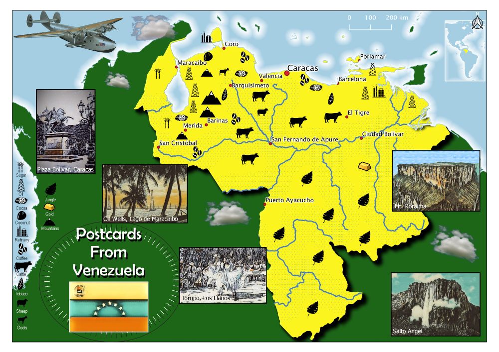
#30daymapchallenge Day 10: Air. Inspired by a PanAm map published in 1950 and the fact that PanAm flew daily from Miami to Maracaibo in Venezuela from 1927. The first regular flights landed on the lake.
10.11.2025 08:16 — 👍 1 🔁 0 💬 0 📌 0
Unrepentant Geographer & Polar Bear.
UU, Atheist, Humanist, Pluralist. Abortion is Healthcare.
Design School GIS & Data Librarian
Opinions here are my own. Reposts are not necessarily endorsement or agreement.
Mapas para entender un poco mejor el mundo // Maps to understand the world a little better
📧 Newsletter (🇪🇸): newsletter.mapasmilhaud.com
📧 Newsletter (🇬🇧): www.cartographerstale.com
🗺 Mapas / maps: mapasmilhaud.com
#rstats geospatial data analyst. GIS expert, of a sort. Sci-fi fan and would be writer. Black cat owner. Occasionally apocalyptical. Can't DM.
WORDS ARE QUICK AND WORDS ARE VAIN, THE SINGLE SURE AND FINAL ANSWER MUST BE PAIN. -Dan Simmons, Olympos
Data analyst and data viz geek
Your loyal 🫡 servant for pro cycling news, interviews, insights, stats, results and the lighter bits.
Free to read, no paywall 💰
https://linktr.ee/domestiquecycling
A self run news account on Brighton News!
Brighton, UK 📍
Specialising in engaging news for college and university students in Brighton 🎄
To contribute your own Story/Idea or give your photography of the city, please email us at:
heybrightonnews@gmail.com
🗞️The latest news from Brighton and Sussex
✉️ Got a story? Email: news@theargus.co.uk
Official feed of Cycling Weekly magazine & website. Bringing you news, racing, interviews, fitness, reviews & buying advice since 1891 - http://bit.ly/3Mw15vc
The official cyclingnews.com – the world centre of cycling
The world’s finest independent cycling publication.
The most trusted voice in music
pitchfork.com
An oasis of artistic excitement (Boston Globe), featuring contemporary classical, jazz, Americana, popular, world, and music theatre.
The Finest In Jazz Since 1939
https://www.bluenote.com/
https://store.bluenote.com/
https://linktr.ee/bluenoterecords
Brighton and Hove Albion news from The Argus I theargus.co.uk/sport/albion I #BHAFC
Official UK Met Office account. Get the weather in your hand with our app: http://linktr.ee/MOContent
Head of Audience at @economist.com. Formerly at BBC News and Bloomberg. Views mine. Covid cautious 😷
Health Editor, The Economist.
My newsletter is about how life is being rewired by new med health tech, and changing ideas about health: overmatter.substack.com/subscribe
Defence Editor at The Economist.
Visiting Fellow at Department of War Studies, KCL. For speaking engagements: https://chartwellspeakers.com/speaker/shashank-joshi
Public policy editor based in the Britain section at The Economist
Charlemagne columnist & Brussels bureau chief, The Economist.
Past stints in Paris, Mumbai, London. Français. Personal feed.
Bio 👇. https://medium.com/@spignal/stanley-pignal-bio-2acd9b705ceb
Charlemagne@economist.com