Wind and -20°C created some wild ice on the trees by beach in #Toronto
07.02.2026 13:14 — 👍 5 🔁 2 💬 1 📌 0
Closes soon!! 🧪⚒️
18.11.2025 23:01 — 👍 9 🔁 8 💬 0 📌 0
Hi! Could I be added as well, please?
02.11.2025 19:37 — 👍 1 🔁 0 💬 0 📌 0

Line graph time series of monthly mean surface temperature anomalies for the Northern Hemisphere region only. Every month is shown from 1940 to July 2025. There is a long-term warming trend in all months of the year.
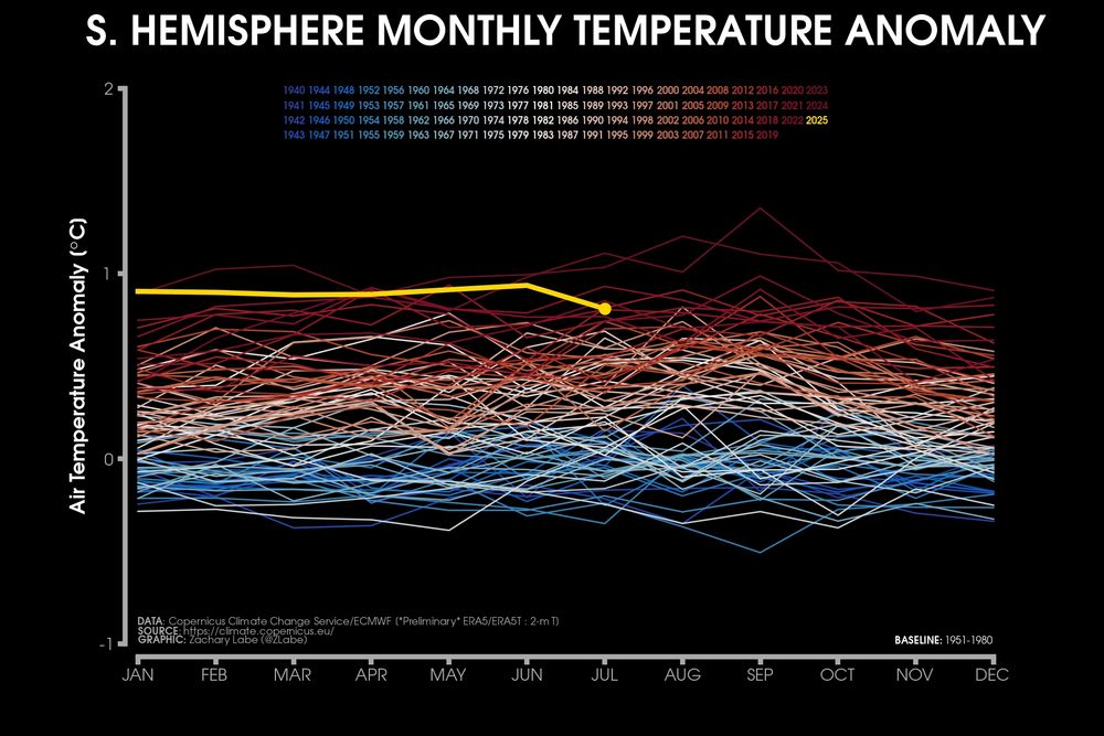
Line graph time series of monthly mean surface temperature anomalies for the Southern Hemisphere region only. Every month is shown from 1940 to July 2025. There is a long-term warming trend in all months of the year.
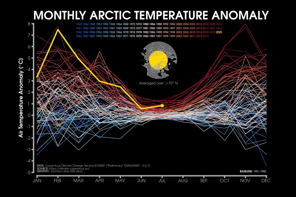
Line graph time series of monthly mean surface temperature anomalies for the Arctic region only. Every month is shown from 1940 to July 2025. There is a long-term warming trend in all months of the year and a strong seasonality in terms of the magnitude of the anomalies.
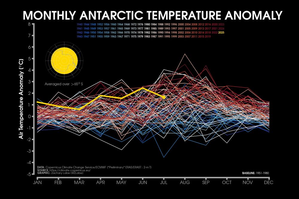
Line graph time series of monthly mean surface temperature anomalies for the Antarctic region only. Every month is shown from 1940 to July 2025. There is a long-term warming trend in all months of the year, but less obvious than the other regions.
Comparing the different seasonality and trends in the magnitude of monthly temperature anomalies since 1940 for the Northern Hemisphere, Southern Hemisphere, Antarctic and Arctic. There are significant differences in the rate of long-term warming (blue to red lines).
Data: doi.org/10.24381/cds...
26.08.2025 20:05 — 👍 45 🔁 20 💬 1 📌 1

Poster for 90 minute workshop on HOW TO DESIGN BETTER EXPERIMENTS, by Mridul Thomas & Ravi Ranjan.
Details: September 23rd 16:00 CEST ; 14:00 UTC
Description:
Experimental designs can make or break an experiment. A good experiment has a clear goal and efficiently uses experimental resources to achieve that goal. In this workshop, we will review what experiments are for, basic and advanced principles of designing experiments, and how to use simulations to evaluate designs before actually doing the
experiment. We’ll do a moderate amount of coding in R and so experience with this would be helpful but is not required. We intend to have small-group discussions to help participants develop their own experiments, and encourage participants to think of a specific question they would like to answer with an experiment.
@raviranjan.bsky.social & I are teaching a free online workshop with on experimental design for environmental scientists on the 23rd.
We'll focus on using simulations to evaluate how well different experimental designs help achieve your goals.
Please sign up & share! forms.gle/MZTxeQs4UpMr...
15.09.2025 11:20 — 👍 27 🔁 21 💬 2 📌 2

Social media image showing a silhouette of a person standing by a lake at dusk or dawn against a cloudy sky. Large white text reads "LET'S REVIVE OUR LAKES" with "Join #GenerationRestoration" below. Decorative elements include a yellow outlined bird, red butterflies, and green palm trees. The UN Decade on Ecosystem Restoration 2021-2030 logo appears at the bottom, featuring colored curved lines. Blue fish illustrations swim in the water below. The image combines a natural lake scene with graphic design elements against a dark, atmospheric background.
Today is the first #WorldLakeDay! 🏞️ Lakes are vital #ForNature, climate resilience & freshwater supply, but are degrading rapidly.🌍🧪
Urbanization is a major cause of lake losses in many countries.
.— IPBES #GlobalAssessment
Explore restoration solutions with @unep.org & @fao.org bit.ly/469N2Ii
27.08.2025 16:54 — 👍 29 🔁 10 💬 1 📌 0
YouTube video by Schmidt Ocean
Lush with Life | Underwater Oases of the Mar Del Plata Canyon
An international team of scientists is documenting remarkable biodiversity and exploring how powerful ocean currents support the #MarDelPlataCanyon ecosystem. Learn more via our latest #TaludContinental_IV expedition in Argentina! 🇦🇷
youtu.be/Ez2GJNz1vSo?...
07.08.2025 22:02 — 👍 43 🔁 11 💬 0 📌 0
PhD Scholarship Available on the development of eco-hydrologic and hydro-geomorphic models in coastal systems, at Deakin University / IITM (Australia-India joint project), Australia. Apply by 10 September. See also: csdms.colorado.edu/wiki/Jobs
11.08.2025 15:29 — 👍 3 🔁 1 💬 0 📌 0
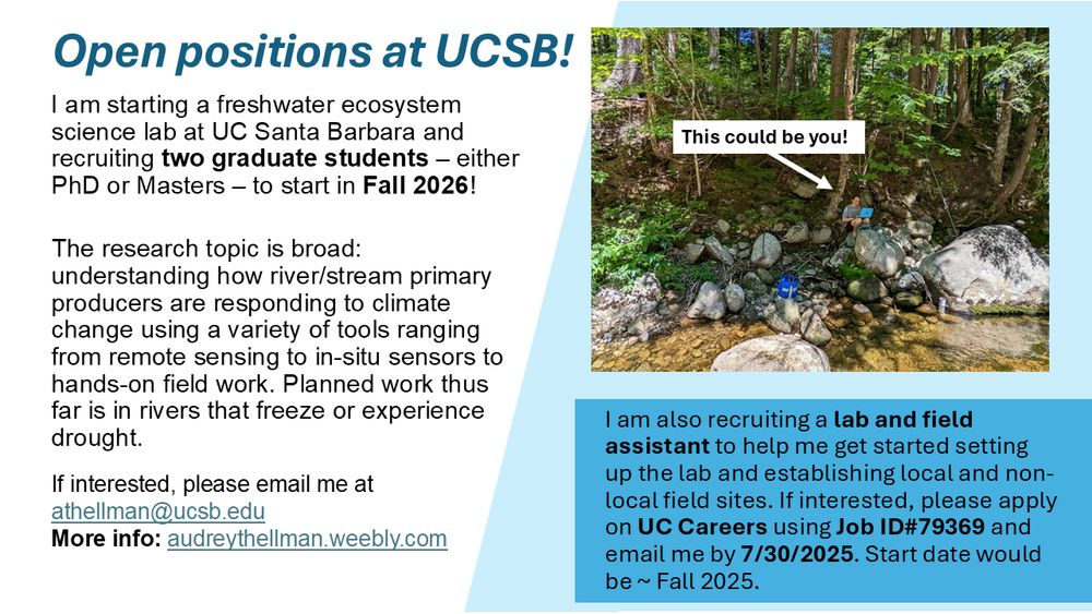
Ad for 2 graduate student positions and and 1 lab and field assistant position at UCSB. More info go to audreythellman.weebly.com
Hello freshwater friends! I’m starting a lab(!!) and recruiting 2 students to start Fall 2026 and a lab/field assistant to start this Fall 2025! Research topic is broad: rivers 🛶, ice/snow ❄️, nutrients 🍂, algae 🌱see below for more info
Please pass this along to any interested folks :)
14.07.2025 20:35 — 👍 12 🔁 9 💬 0 📌 3

Schematic diagram showing the influence of sea-level change on fluvial transverse and axial drainage systems in the Taiwan Strait. (A) Palaeo–Choushui River sediments were transversely transported from wedge-top areas to the emergent forebulge during the Last Glacial Maximum. Along the east side of the forebulge, some fluvial sediments were transported southwards and axially via the linear sediment conduit of the connected river valley–submarine canyon to the South China Sea. (B) Beginning around 9.5 ka BP to the present sea-level highstand, the narrow seaway east of the forebulge became a foredeep filled with shallow marine sediments. The Choushui River empties sediments from wedge-top areas into the Taiwan Strait, where they are redistributed and transported mainly by the north-flowing Taiwan Warm Current, resulting in an axial sediment dispersal pattern.
Let's say you have a big river, and active tectonics, and strong ocean currents, like, for example, around Taiwan, there are going to be a lot of modes of sediment dispersal, and they will alternate over time. 🧪⚒️
Link: onlinelibrary.wiley.com/doi/10.1002/...
30.06.2025 14:06 — 👍 7 🔁 2 💬 2 📌 0
Loved Deumheller! Wish I could be back!
12.07.2025 18:53 — 👍 0 🔁 0 💬 0 📌 0

A flyer for an AGU 2025 session titled, "A082: New Perspectives on the Exchange of Reduced Nitrogen Between the Atmosphere, Land, and Water from Remote Sensing, in situ Measurements, and Modeling Approaches"
The description reads,
"Reduced nitrogen from source to impact! From wildfires to agricultural inputs, diverse sources of reactive nitrogen drive significant ecological changes including eutrophication, harmful algal blooms, and aquatic food web disruption across multiple environmental systems. Submit an abstract to our interdisciplinary session exploring atmospheric, terrestrial, and aquatic perspectives. We welcome contributions using remote sensing, field measurements, and modeling approaches that span complexity and spatiotemporal scales. Sections: Atmospheric Sciences, Biogeosciences" The conveners are Dr. Matthew Davis, Dr. Kimberley Corwin, and Dr. Lauren Magliozzi of Colorado State University. There is a QR code for the submission link, and the deadline is listed as 30 July 2025.
The text is black on white boxes with blue accents, and the background features a blue sky with large, white clouds.
New @agu.org session! Reduced nitrogen from source to impact: an interdisciplinary session on reduced nitrogen's complex environmental role. Invited speakers include USGS limnologist Dr. Michael Meyer @mishafredmeyer.bsky.social & Georgia Tech atmospheric scientist Da Pan #AGU2025 🧪🔥⚒️
02.07.2025 15:01 — 👍 6 🔁 2 💬 0 📌 1
Great summary of our recent paper on sea level rise during a past warm period and what it means for our future. Thanks, @climateages.bsky.social , for featuring our work.
23.06.2025 15:09 — 👍 53 🔁 21 💬 6 📌 0
Il satellite Biomass dell'ESA, lanciato a fine aprile, ha iniziato a inviare le prime immagini
23.06.2025 15:10 — 👍 24 🔁 6 💬 0 📌 0
Happy Monday! 🥳
Thrilled to share our new paper in Children’s Geographies:
“Place-based & intergenerational storytelling for youth climate action: Moving beyond participation and towards momentum” 🌍📚
Read it here: www.tandfonline.com/eprint/IHFXJ...
23.06.2025 08:22 — 👍 6 🔁 3 💬 1 📌 0
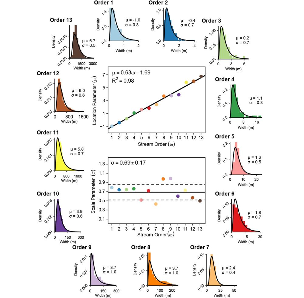
River widths of each stream order exhibit predictable log-normal distributions.
🚨New paper🚨 shows a remarkably clean relationship between river width and stream order across the US
𝑇ℎ𝑒 𝑊𝑖𝑑𝑡ℎ𝑠 𝑜𝑓 𝑅𝑖𝑣𝑒𝑟𝑠 𝑎𝑛𝑑 𝑆𝑡𝑟𝑒𝑎𝑚𝑠 𝐴𝑐𝑟𝑜𝑠𝑠 𝑆𝑝𝑎𝑡𝑖𝑎𝑙 𝑆𝑐𝑎𝑙𝑒𝑠... 🔗 doi.org/10.1029/2025...
#hydrology #geomorphology #rivers #RemoteSensing
19.06.2025 14:10 — 👍 21 🔁 6 💬 1 📌 1
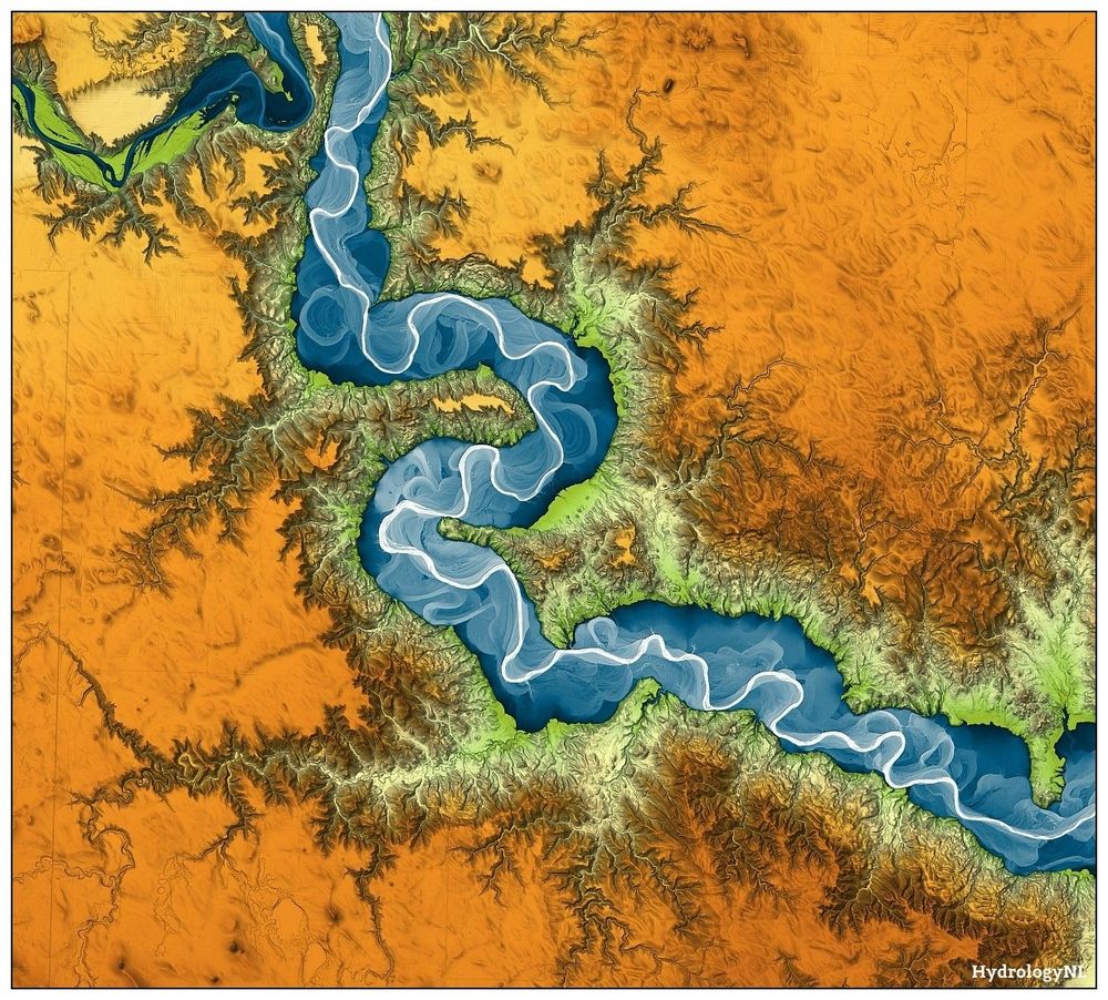
Digital elevation model of the Grand River, South Dakota, USA. River floodplain in blue (high) to white (low), the rest of the landscape in orange (high) to green (low). The river meanders, the landscape on both sides of the floodplain is eroded with finger-like gullies.
A nice river, somewhere, meandering through a bit of glacial deposits and cutting into Upper Cretaceous shale and sandstone.
High-resolution prints are for sale on request (special edition!).
22.06.2025 01:32 — 👍 81 🔁 21 💬 5 📌 2

Wow! Since 2005, Paris has slashed air pollution by 55% - a staggering win for public health and climate. How? Bold green urbanism. The city curbed car traffic, expanded bike lanes and boosted public transport. When people and planet are prioritised, the air gets cleaner and lives get better.
18.06.2025 09:58 — 👍 121 🔁 47 💬 4 📌 4
It’s sad to see the EEI say goodby to you, Tom.
18.06.2025 13:43 — 👍 1 🔁 0 💬 0 📌 0

A satellite image showing the junction between two fairly large rivers. They are surrounded by a mixture of farmland and floodplain trees and shrubs. Both rivers have colors indicating significant sediment load, but one is greenish gray and the other is distinctly browner colored.
Junction of the Missouri and Yellowstone Rivers just east of Montana/North Dakota state line with distinctly different colors from suspended sediment (Missouri flows from upper left to upper right). Sentinel 2 image, June 9, 2025.
15.06.2025 02:27 — 👍 42 🔁 5 💬 2 📌 0

The mud waves formed when water from the north and south, with very different salinities, were mixed together following the final split of South America and Africa. (Image credit: courtesy of D Duarte et al/Heriot-Watt University)
Gigantic 'mud waves' buried deep beneath ocean floor reveal dramatic formation of Atlantic when Africa and South America finally split
Early Cretaceous deep-water bedforms west of the Guinea Plateau revise the opening history of the Equatorial Atlantic Gateway🧪
www.sciencedirect.com/science/arti...
22.05.2025 15:30 — 👍 13 🔁 4 💬 0 📌 1
OOS2025 - Live-streamed sessions
With the UN Ocean Conference #UNOC3 in its final days, it's worth watching again the Keynote talks of its #OneOceanScienceCongress.
They provide an excellent overview of the issues faced by the ocean, including #fisheries, #carbon and #governance
one-ocean-science-2025.org/programme/li...
12.06.2025 09:00 — 👍 12 🔁 3 💬 1 📌 0
Geomorphologist, Water/Civil Engineer
PDRA in Multi-hazard Modelling, University of Edinburgh
Professor (Asst) IOE, Pulchowk Campus, Tribhuvan University
Photos of interesting bicycle 🚲 stuff around Toronto
💻🎙️🗞️ Jornalista
🌊🐟 Entusiasta da vida aquática
🌎📍 Brasil 🇧🇷
Research Fellow in Glaciology at Monash University, Australia 🇦🇺 Home country Georgia 🇬🇪 Glacial-geomorphological studies ❄️🗻 Cosmogenic nuclide dating 💥☄️Remote Sensing 🛰 Cartography and GIS 🗺 Father of three cubs 🐯🐺🦁
European Fresh and Young Researchers (EFYR) - European Federation for Freshwater Sciences (EFFS)
A committee of fresh and young people supporting early-career scientists and professionals in fresh waters across Europe
https://agnes-riviere.github.io
Earth researcher: critical zone, hydrology, hydrogeophysics, geothermal and water uses modeling, global changes
https://agnes-riviere.github.io/GWSBound
Polar scientist & glaciologist. Sec Gen for @igsoc.bsky.social. Trail running. Still new to this platform & figuring things out!
Physical Geography Professor | Soil and Landscape Evolution | Climate Change | Researcher | UFBA and CUNY 🌎🔬
https://colapso.ggf.br/
Field geologist, US Antarctic Program investigator - West Antarctica, College professor, Proterozoic-lover, admirer of Iphigene Ochs. Favorite mineral: Cordierite. Best rock types: mylonite, kinzigite and diamictite! Favorite weather: blowing snow.
Polar microbiology research group led by Chris Williamson
+ 2025 | Scientist - Fluvial Geomorphology | 🇦🇺
______
+ 2025 | PhD | Geospatial and Fluvial Geomorphology 🇦🇺
+ 2020 |Joint MSc | Water and Coastal Mgt. | 🇮🇹 🇪🇸 🇵🇹
+ 2015 | BSc (Hons) | Water Resources Mgt. | 🇳🇬
Marine Scientist, GIS nerd, all things ocean. Loves to be in the nature. Hawaii is home.
Applying and developing DNA-based molecular tools for the study of ecosystems and biodiversity.
Working at #TaxusMedioAmbiente. Spain.
Metabarcoding | eDNA | Phylogenetics | Pop Gen
The Global Lake Ecological Observatory Network conducts innovative science to understand, predict and communicate the role and response of lakes in a changing global environment.
PhD student in Glaciology🍦
⌨️Poetry
📍Austrian now @NTNU in Trondheim 🇳🇴
📍Studying Glacier Hydrology ❄️🧊💧through 🔎 Firn, Snow, pressurised 🌊,GLOFs & Glacierdynamics⚡️
🐧APECS Norway National Committee Member
📍Fieldwork sites in:
Norway, Svalbard & Pakistan
Professor at the University of Innsbruck. Limnology| Microbial Ecology|Biogeochemistry|Photobiology
Fostering European Lake Restoration - project funded by Horizon Europe
Boldly exploring our unknown Ocean
UCSB professor who loves rivers and biogeochemistry! 🛰️🧊
The Society for Freshwater Science (SFS) is an international scientific society whose purpose is to promote understanding of freshwater ecosystems. #2026SFS https://freshwater-science.org/