I really like the was this map is composed, definitely a work of art
20.11.2025 01:40 — 👍 1 🔁 0 💬 1 📌 0

#30DayMapChallenge - Day 20- Water
Today's map is just lakes in Minnesota. The title was inspired by the Capt Crunch's Oops All Berries. I did play around with the reference scale to try and make the lakes stand out without being overpowering, unlike the box of crunch berries.
20.11.2025 01:39 — 👍 6 🔁 1 💬 0 📌 0

#30DayMapChallenge - Day 19 - Projections
Seeing how Alaska gets squished, pulled, and distorted to fit in these different coordinate systems. Definitely explains how I got much of the way through grade school before realizing the sheer size of Alaska.
19.11.2025 02:54 — 👍 12 🔁 2 💬 0 📌 0

#30DayMapChallenge - Day 18 - Out of this World
I have never heard of Planet Smoothie until yesterday when I asked ChatGPT for some inspiration.
19.11.2025 00:05 — 👍 2 🔁 0 💬 0 📌 0

#30DayMapChallenge - Day 17 - A New Tool
So the new tool / process I tried this time was using the Raster Calculator in QGIS to run NDVI on this orthoimagery dataset that I downloaded for Adams County, Ohio. Why Adams County? That's the "Roulette Part"
18.11.2025 03:43 — 👍 3 🔁 0 💬 0 📌 0
It’s a while since I’ve utilized Tool while ground truthing my daily commute 🤔
17.11.2025 21:24 — 👍 1 🔁 0 💬 0 📌 0

#30DayMapChallenge - Day 16 - Cell
Took the 2024 NCLD data, clipped it to South Dakota, then resampled the data to various resolutions. Nothing fancy...
17.11.2025 01:08 — 👍 6 🔁 0 💬 0 📌 0
I used ESRI (ArcGIS Pro and Enterprise) at work. For these challenges I make the maps in QGIS using my personal MacBook Pro. All but one of these maps was completely composed in QGIS while the city map was started in QGIS and finished in Adobe Photoshop.
15.11.2025 18:26 — 👍 1 🔁 0 💬 1 📌 0
Thanks! I make a lot of serious maps at work so during these challenges I try to have fun while getting more familiar with QGIS.
15.11.2025 17:19 — 👍 1 🔁 0 💬 1 📌 0

#30DayMapChallenge - Day 15 - Fire
I almost made a map with a more serious tone, but then I came to my senses. Here is another Taco Bell map. Vermont only has 5 locations (same as Taylor, Michigan actually) and if I squint really hard, Vermont is sort of shaped like a torn Fire sauce packet.
15.11.2025 03:44 — 👍 9 🔁 1 💬 1 📌 0
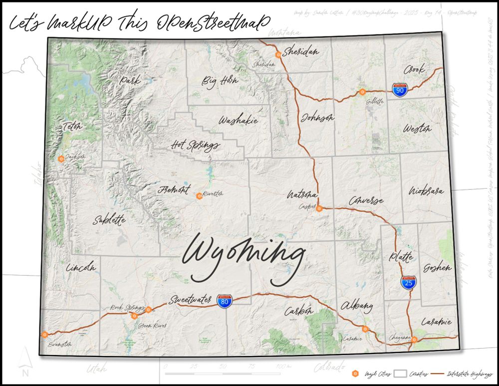
#30DayMapChallenge - Day 14 - OpenStreetmap
I really wasn't sure how to approach this theme so I started with a base map layer from OpenStreetMap. Then I just sort of "scribbled" all over it. No real direction, just playing around with layers and fonts.
14.11.2025 03:20 — 👍 3 🔁 0 💬 0 📌 0

#30DayMapChallenge - Day 13 - 10 Minute Map
10 Minute Map? Well...probably more like 12 minute map.
Quick and dirty map? Definitely.
There is an obscure music pun hidden in the map if you can find it.
13.11.2025 03:08 — 👍 6 🔁 0 💬 0 📌 0

#30DayMapChallenge - Day 12 - Map from 2125
This is by far the most challenging day for me during this challenge; I wasn't sure how to interpret it. I chose make a hypothetical high speed rail map of the lower 48 states of the US. I'm not sure how I feel about it, but there is always tomorrow.
12.11.2025 03:20 — 👍 9 🔁 0 💬 2 📌 0
I’d be interested to see how your QGIS methodology compares to the one I used for my Iowa Joy Plot 👍
11.11.2025 15:34 — 👍 1 🔁 0 💬 1 📌 0

#30DayMapChallenge - Day 11 - Minimal Map
For today's map, I kept things minimal (including the effort).
11.11.2025 03:18 — 👍 8 🔁 0 💬 0 📌 0

#30DayMapChallenge - Day 10 - Air
Woke up on Sunday morning to find snow on the ground with flurries throughout the day. Needless to say, this map idea was inspired by Sunday's weather. Brrrrr....🥶
10.11.2025 01:44 — 👍 6 🔁 0 💬 0 📌 0
I mean the only other state that I might confuse it for is Colorado.
09.11.2025 23:57 — 👍 2 🔁 0 💬 1 📌 0
I love it! I was talking to a coworker about a map like this.
09.11.2025 22:39 — 👍 2 🔁 0 💬 1 📌 0
That is really cool!
09.11.2025 20:01 — 👍 0 🔁 0 💬 0 📌 0

#30DayMapChallenge - Day 9 - Analog
I shall call it LEGO-HIO! I've made a few LEGO maps in ArcGIS Pro, so why not try it with real LEGO. Would have been nice if the colors matched but at least I had enough flowers for the big cities. 100% FUN!
09.11.2025 03:40 — 👍 5 🔁 0 💬 0 📌 0
I’m really digging the Rhode Island theme that you’ve been doing for this challenge.
08.11.2025 18:16 — 👍 2 🔁 0 💬 1 📌 0

#30DayMapChallenge - Day 8 - Urban
Today I decided to just experiment and play around with visualization, nothing too crazy or purposeful. Obviously I am focusing on Detroit but several suburbs are also included. I did highlight the road network and freeways for some razzle dazzle.
08.11.2025 04:22 — 👍 9 🔁 0 💬 0 📌 0

#30DayMapChallenge - Day 7 - Accessibility
In 2010, I went on a weekend trip to Chicago. This trip left a lasting impression on me of how a decent rail system can make a large city so accessible without a car. This map shows a one mile buffer from the "L".
07.11.2025 02:59 — 👍 12 🔁 1 💬 0 📌 0

#30DayMapChallenge - Day 6 - Dimensions
Today I am exploring the "time" dimension and exploring the decline of Rite Aid within Michigan and Ohio. In the end, Rite Aid closed of their all stores.
06.11.2025 01:43 — 👍 6 🔁 0 💬 1 📌 0

#30DayMapChallenge - Day 5 - Earth
I always thought these types of elevation maps were really cool. I figured why not revisit it (I made one last year for New Hampshire). Why Iowa? Why not. I did have to add a "multiplier" to the elevation to try and make the effect look a bit more visible.
05.11.2025 01:50 — 👍 11 🔁 0 💬 0 📌 0
Impressive! I’ve been to several but nowhere near that number. While I can’t speak for Redwood, I agree that your other three top parks are amazing.
04.11.2025 17:21 — 👍 1 🔁 0 💬 1 📌 0
Thanks! I missed CT by a few miles but even crazier is that my route out missed NJ by mere feet on that roadtrip.
04.11.2025 17:18 — 👍 1 🔁 0 💬 1 📌 0
Thanks! I’ve played around this idea but never tried it with all of my cars.
04.11.2025 17:16 — 👍 1 🔁 0 💬 0 📌 0
Thanks! One of my favorite things about this challenge is connecting with people and getting a better understanding of the actual place/subject that the map is about. 🙂
04.11.2025 17:12 — 👍 1 🔁 0 💬 1 📌 0
Health Data Science | 📊 DataViz | 📖✨️ | 🐾
Looking for health data analytics or data science position.
LinkedIn: www.linkedin.com/in/darakhshan-nehal-b38747154/
GitHub: https://github.com/darakhshannehal
Nerd and geek, ADHD, GIS
he/him
Visual Management Professional | Facilitator | Speaker | Geographer | Knowledge Worker
LinkedIn - https://www.linkedin.com/in/nolantim/
Husband and dad. Golden Girls super fan. Lana Del Rey and Dolly Parton fan, too. Car aficionado, ‘80s and ‘90s culture freak, and classic country music lover. Deconstructing Christian - not sure what all that entails yet, but we’ll find out. LGBTQ ally.
Comedy Car Show on YouTube (NSFW). Philadelphia
The bones are the skeletons' money
youtube.com/@JohnWolfe
youtube.com/@JohnTwolfe
instagram.com/JohnWolfeYT
Seafloor mapper, Chief Scientist of smart mapping company Esri, Oregon State U. GIS/oceans professor, EC50, cyclist, 1st Black submersible diver to Challenger Deep, builds w/LEGO, raised in Hawaii. NAS, NAE, ORCID 0000-0002-2997-7611; She/her; views mine
Spatial thinking and applying Geotechnologies can transform educational practice and lead to better decision making in society.
Maps, cartography, science.
MAPPING FAN! NAPPING STAN!
Technical Solutions Specialist at Esri Canada
Burnaby, BC, Canada
https://linktr.ee/markhogis
(hot takes are my own)
Senior Product Manager of Mapping & Cartography @ Esri. Previously @washingtonpost.com and National Geographic. Map-maker and geographer. portfolio: laurenctierney.com
Writer/editor at Esri, relating innovation in the real world to the power of GIS. I edit Esri Blog—Better vision. Better world. #Sustainability
Esri product engineer for health and public safety solutions. Colorado is home.
Geographer, landscape archaeologist, podcaster...https://veryspatial.com
Lois Lane for the courts and broken tigger
Slate, Amicus, MSNBC, NYT bestseller Lady Justice
I am a GIS professional and teacher of GIS. I focus on environmental modeling, remote sensing, LiDAR, and GIS. Also currently working on my PhD in Computing Information Sciences with a focus on HCI and Emergency Management.
Technical Marketing Manager, EsriCanada | Curl & Coach, High Park Club | Coach, Annette Baseball | Coach, George Bell Hockey Association | Opinions are mine.