Hi - you can use the lidR package in R to go directly from a bunch of .laz files to an elevation matrix:
# load lidar elevation data
ctg <- lidR::readLAScatalog("/path/to/your/laz_data/")
las <- lidR::readLAS(ctg, select = "xyz")
dem <- lidR::grid_canopy(las, res = 1, p2r())
03.01.2025 14:24 — 👍 1 🔁 0 💬 0 📌 0
La tour Eiffel, Paris
Palais de l'Alma is masked in the data, so its footprint has become a water feature
LiDAR geoservices.ign.fr, overlays @openstreetmap.bsky.social, rendered in #rayshader #rstats #maps
16.12.2024 12:36 — 👍 25 🔁 3 💬 2 📌 0
Cardiff?
04.12.2024 17:47 — 👍 2 🔁 0 💬 1 📌 0
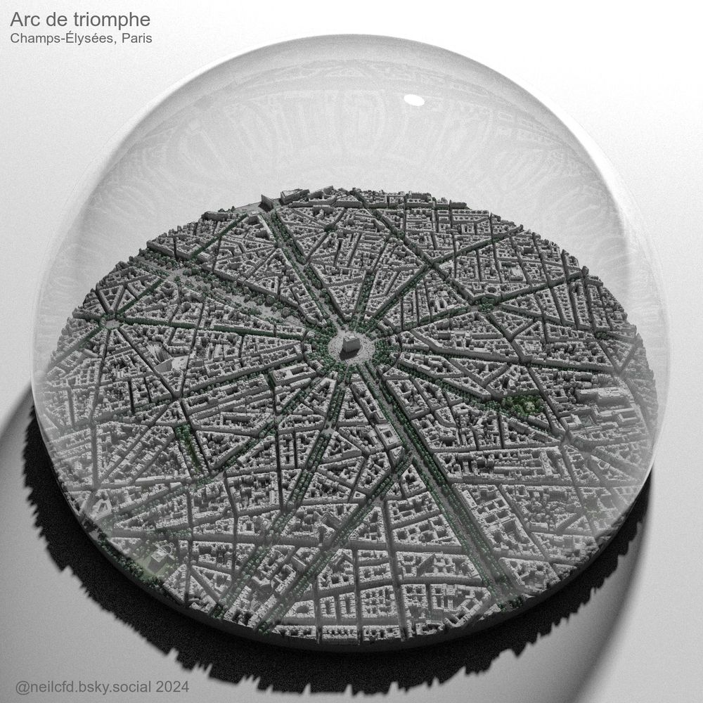
Arc de triomphe, Champs-Élysées, Paris
An upside to taking an absence from posting for 18 months is that fantastic new data has appeared in the interim.
LiDAR geoservices.ign.fr, overlays @openstreetmap.bsky.social, rendered in #rayshader #rstats #maps
03.12.2024 11:46 — 👍 23 🔁 5 💬 0 📌 1
yep, using the rayshader package in R by @tylermorganwall.bsky.social
30.11.2024 19:15 — 👍 1 🔁 0 💬 0 📌 0
#30daymapchallenge Day 30: The final map
Vienna, Austria. The final map I posted to the other place in June 2023 before my Musk-ation, cropped to the 50MB bsky limit. LiDAR www.wien.gv.at/, overlays @openstreetmap.bsky.social, rendered in #rayshader #rstats #maps
Time to make some new things now!
30.11.2024 14:04 — 👍 24 🔁 6 💬 1 📌 0
Just encountered this too, that 50MB limit is a little annoying!
30.11.2024 13:46 — 👍 1 🔁 0 💬 0 📌 0
Moving another of the archive over, here is Lighthouses of Ireland, UK, Northern France and Belgium. Data from
🇮🇪 www.irishlights.ie
🇬🇧 www.trinityhouse.co.uk
🇫🇷 www.shom.fr and in particular
www.nlb.org.uk for lights of 🏴 and 🇮🇲. Additional data from msi.nga.mil and @wikipedia.bsky.social
27.11.2024 11:33 — 👍 16 🔁 5 💬 0 📌 0
Lucky you, I'd love to see the race village and the start!
20.11.2024 16:44 — 👍 1 🔁 0 💬 0 📌 0
Yes please!
20.11.2024 09:52 — 👍 1 🔁 0 💬 0 📌 0
A repost of Vendée Globe Race 2020-21 (sailing singlehanded around the world). The 2024-25 edition started on 10th November. Rendered in #rayrender #rstats
20.11.2024 09:46 — 👍 27 🔁 5 💬 1 📌 0
The Geology of the Moon | Lunalogy
A concept visualization highlighting a wide variety of geological features on our celestial neighbor. Created for the #30DayMapChallenge - Space and Time. Made in Blender, some #rstats, Illustrator & DaVinci Resolve. #GIS
19.11.2024 14:32 — 👍 91 🔁 23 💬 7 📌 4
That is wonderful, Julian
19.11.2024 15:12 — 👍 2 🔁 0 💬 1 📌 0
Thank you! I've made a few of these lighthouse maps over the years, I'll post them over the next couple of weeks
19.11.2024 08:55 — 👍 1 🔁 0 💬 0 📌 0
Thank you, it's nice to be back, looking forward to making some new work!
19.11.2024 08:53 — 👍 1 🔁 0 💬 0 📌 0
Thanks, Terence, not sure I would have embarked upon it if I'd known how much work would be involved 😂
19.11.2024 08:52 — 👍 1 🔁 0 💬 0 📌 0
Full of hope that Bluesky will become what the other place once was, so here is a repost of Lighthouses of France 🇫🇷
Data from shom.fr, msi.nga.mil and @wikipedia.bsky.social
Layout based on the wonderful 1848 map here: bit.ly/3xuFopu (thanks, @gardien2phare.bsky.social 😀)
18.11.2024 12:18 — 👍 159 🔁 43 💬 5 📌 6
Walker Environmental Research // Environmental Data Science & Engineering // Maine // walkerenvres.com
Likes: GIS, geology, needlework, reading, the outdoors, video games, dairy products, and, most importantly, my husband and my dog.
Dislikes: lactose, humidity, static electricity, and joins.
Expat: 🇺🇸—>🇦🇪🇫🇷🇪🇸
Data Engineer @ MARS-IMEO-UNEP
Data-Driven Geoscience:
- Computation Scientist
- GeoSpatial Data Engineer
- AI/ML Research Engineer
- MLOPs Dev
- Developer Advocate
I truly believe that software will save science!
climate scientist
posts 100% my own
🇨🇦 is my home
distinguished professor & chair, Texas Tech
chief scientist, The Nature Conservancy
board member, Smithsonian NMNH
alum, UToronto and UIUC
author, Saving Us
graphics editor @FT | prev @BBCNews @the_young_fdn | data viz @LCCLondon
https://www.ft.com/jana-tauschinski
Architect; 🛰️Satellites, 🗺️Maps & 🌐Geospatial - Porto Alegre, Brazil.
🔥🗺️ Pyrogeographer.
🛰️🛩️🔥 #RemoteSensing of #Wildfire.
❤️🚒 Passionate about finding ways to help emergency responders.
📣 #SciComm
👩💻 https://www.kristaleewest.com/
📍 Colorado, USA
Generative Design 🎨 - Coding 🧑💻 - Science Communication 🧬
Utility nerd. Interested in math, linguistics, geography, history, reading, statistics, data science, coding (R, Python, Java, SQL, and TI BASIC), and baseball, among other things.
ArcGIS Online product manager at Esri. Maps, Web GIS, enterprise-grade content management tools. I manage the ArcGIS Online Early Adopter Community. Can be found at events such as FedGIS, Dev & Tech Summit, and the Esri User Conference. Come say hi 👋
GIS/RS/EO, Clean Water Act, disaster response, public service, New England Aquarium, fiddle-playing, fantasy-reading, fishing, kayaking, pirates.
From Fresh Water. Opinions my own.
Open source geospatial - analysis, development & cartography. Shitposting, Cats and Climbing. Opinions my own.
Scientist | #Arctic | #Belowground | #Roots | #ScienceEmbroidery | Opinions my own | She/Her | Editor @newphyt
www.colleeniversen.com
IG: @colleeniversen
Graphics for cyberspace
https://btjak.es
🗺 Cartographer #gis
🇨🇦Canadian
Science communicator | Lover of Landsat, geospatial data, stories, and cool maps 📡🌎🛰️