Images of predator free zones on the South Island of New Zealand
📱➡️🌿 From Garmin GPS + paper notebooks to real-time digital field data collection!
Zero Invasive Predators transformed their conservation operations using QField, reducing data turnaround from 2 weeks to daily sync.
Speed saves species when predators can move 20-30km in weeks!
buff.ly/Sdh2wCQ
25.08.2025 05:16 — 👍 2 🔁 1 💬 0 📌 0
Requerimientos:
Computadora portátil con QGIS 3.40 Bratislava instalado, y muchas ganas de aprender!
30.06.2025 14:10 — 👍 0 🔁 0 💬 0 📌 0
No es necesario tener conocimientos previos, por eso es ideal para quienes nunca utilizaron SIG pero quieren aprender!!!
30.06.2025 14:10 — 👍 0 🔁 0 💬 1 📌 0

Contenidos: Introducción a los SIG. QGIS y su interfaz gráfica. Carga de datasets vectoriales, ráster y capas base. Estilos básicos. Edición de datos y vectores. Creación de capas vectoriales. Preparación de salidas gráficas básicas.
30.06.2025 14:10 — 👍 0 🔁 0 💬 1 📌 0

Todavía hay cupos! Desde la IDE Pergamino estaremos en la Ciudad de La Plata brindando un taller de 4 hs de duración: Introducción a los SIG (QGIS). Totalmente gratuito!!!
Anotate acá --> jornadas.idera.gob.ar/index_taller...
30.06.2025 14:10 — 👍 0 🔁 0 💬 1 📌 0

Queremos contarles que estaremos presentes en las Jornadas IDERA 2025 de La Plata. Es una excelente oportunidad para conocer gente del ambiente y capacitarse con los mejores!
Es gratis y abierto, previa inscripción.
jornadas.idera.gob.ar
Daremos un taller introductorio de QGIS y una charla!
24.06.2025 11:13 — 👍 1 🔁 1 💬 0 📌 0

Buen lunes! La Luna nos acompaña desde temprano...
23.06.2025 10:44 — 👍 0 🔁 0 💬 0 📌 0
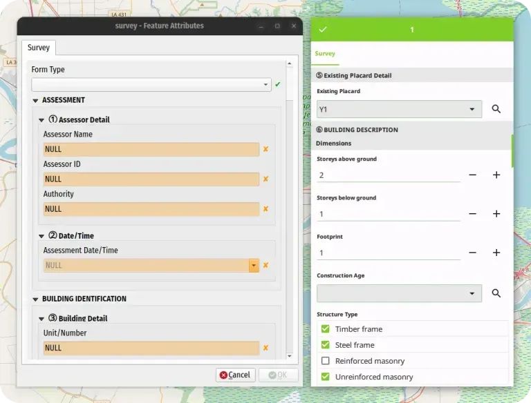
Split screen showing XLSForm Converter results: QGIS desktop survey form on left and corresponding QField mobile interface on right displaying building assessment survey fields.
🚀 NEW: XLSForm Converter plugin for #QGIS!
Convert Excel/LibreOffice surveys into spatial #QField projects with one click:
✅ Auto QField configuration
✅ QFieldCloud integration
✅ Media capture support
✅ Perfect for existing XLSForm users
buff.ly/FBXRZmr
11.06.2025 05:16 — 👍 1 🔁 2 💬 0 📌 0

Sumamos una nueva capa espacial a nuestra IDE: Manchas urbanas históricas de la Ciudad de Pergamino, desde 1773 a 2025.
Contiene el dato del contorno urbano probable a medida que la Ciudad fue creciendo, desde sus orígenes.
Consultalo acá: geonode.pergamino.gob.ar/catalogue/#/...
11.06.2025 16:17 — 👍 0 🔁 0 💬 0 📌 0

Nueva capa espacial: Baños públicos en Pergamino.
Consultá los datos aquí: ide.pergamino.gob.ar o geonode.pergamino.gob.ar/catalogue/#/...
09.06.2025 11:29 — 👍 0 🔁 0 💬 0 📌 0

Comienza el Taller sobre Información Geoespacial para la Gestión del Riesgo de Desastres.
www.youtube.com/live/DnMiXiw...
#IGN #Argentina
05.06.2025 14:07 — 👍 1 🔁 0 💬 0 📌 0
En breve actualizaremos esta noticia! Quedate atento!
29.05.2025 16:17 — 👍 0 🔁 0 💬 0 📌 0


Además, para quienes trabajan con los datos espaciales de OSM podrán acceder a esta información vectorial!
Por ejemplo, desde #QGIS con el plugin #QuickOSM
29.05.2025 16:17 — 👍 0 🔁 0 💬 1 📌 0


Hola! Queremos contarte que estamos actualizando en #OpenStreetMap el material de cobertura de calle (etiqueta "surface"), con los datos de nuestra IDE.
De esta forma los ruteadores basados en OSM pueden utilizar ese dato para ofrecer mejores instrucciones GPS.
29.05.2025 16:17 — 👍 1 🔁 1 💬 1 📌 0
Wow!
22.05.2025 12:25 — 👍 0 🔁 0 💬 0 📌 0
We've done it 🥳
Finally, there's a canonical paper on the #QGIS project, its history, workings, and challenges: https://www.sciencedirect.com/science/article/pii/S2666389925001138
Thanks to @timlinux and @mbernasocchi for joining me in trying to tell the QGIS story 💚
#OSGeo #GISChat #GIScience
21.05.2025 18:17 — 👍 44 🔁 42 💬 3 📌 2
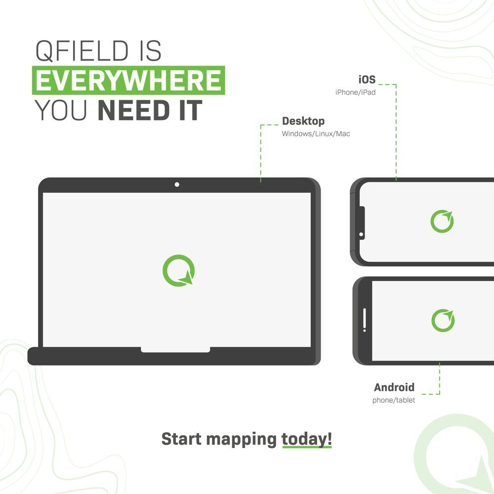
📱 QField goes wherever you do. Android? Check. iOS? Check. Desktop? Check.
If it has a screen, we’re probably on it. Collect GIS data anywhere, anytime.
#QField #OpenSourceGIS #fieldwork
22.05.2025 05:16 — 👍 4 🔁 2 💬 0 📌 0
Te invitamos a conocerlo!
Si te gustó, comparte!
14.05.2025 14:00 — 👍 0 🔁 0 💬 0 📌 0


Para acceder a cualquier dataset podés navegar libremente por el catálogo, hacer una búsqueda por esquema o palabra clave. También podes utilizar el buscador superior!
14.05.2025 14:00 — 👍 0 🔁 0 💬 1 📌 0

Pergamino tiene, desde hace unos meses, un gestor de datos espaciales llamado GeoNode. Podés ingresar desde aquí: geonode.pergamino.gob.ar#/
Vas a encontrar documentos, datasets, mapas y mucho más!
14.05.2025 14:00 — 👍 0 🔁 0 💬 1 📌 0

¿Conoces el geoportal de Pergamino? Explora el territorio y descubre cada detalle en un solo lugar. #DatosGeográficos #IDE #Pergamino #GeoNode
En este hilo te explicamos como acceder, seguinos 👇
14.05.2025 14:00 — 👍 1 🔁 1 💬 1 📌 0

Amanece en #Pergamino y ya se empiezan a notar los colores del otoño.
Desde el 5to piso del edificio Azul, oficina de Modernización, Innovación y Tecnología, donde nace la magia de la IDE.
15.04.2025 10:37 — 👍 1 🔁 0 💬 0 📌 0

Actualizamos los mapas PDF en formato A1 y A0 para la Ciudad de #Pergamino!!!
Descargalos acá:
geonode.pergamino.gob.ar/catalogue/#/...
01.04.2025 16:57 — 👍 0 🔁 0 💬 0 📌 0

Revolución de Mayo - Wikipedia, la enciclopedia libre
Si querés conocer más, visitá:
Wikipedia: es.wikipedia.org/wiki/Revoluc...
Callejero: geonode.pergamino.gob.ar/catalogue/#/...
Servicios Sanitarios: geonode.pergamino.gob.ar/catalogue/#/...
31.03.2025 15:54 — 👍 0 🔁 0 💬 1 📌 0

La foto inicial de este hilo muestra uno de sus patrimonios más emblemáticos: las líneas de Jacarandá en ambas veredas, presentes de punta a punta en la Avenida De Mayo (aproximadamente 200 árboles).
31.03.2025 15:54 — 👍 0 🔁 0 💬 1 📌 0
Official account for the Humanitarian OpenStreetMap Team. We use open geospatial data and tech for humanitarian response and community-led development. Find all our key resources and links at https://linktr.ee/hotosm
Java Web Application to share and edit geospatial data. Publish data from any major spatial data source using open standards.
Web portal focusing on Linux and Open Source.
Follow us for
- Linux and Open Source news
- Linux tips and tutorials
- Linux and geek memes
Profesionales del Territorio, el Medio Ambiente y los Sistemas de Información Geográfica - #SIG. Servicios de #Formación, #Consultoría y #DesarrolloSIG. https://geoinnova.org
Working towards a Cloud-Native Geospatial future, through involvement in GeoParquet, Planet Labs, Taylor Geospatial Engine, Fiboa, STAC & Source Cooperative.
Associate Professor at #ihedelft | Owner of QWAST-GIS Consultancy & Training | Physical Geographer | #OpenSource advocacy | board member #qgisnl | #OSGeo […]
[bridged from https://fosstodon.org/@hansakwast on the fediverse by https://fed.brid.gy/ ]
Geología terrestre y planetaria. PhD student. ES/VAL/EN.
Contacto 📩: nchazarra (at) gmail.com www.ungeologoenapuros.es
Físico, UNAHUR, Ex UBA-CONICET, Ex decano @exactas_uba, Ex Subsecretario de Evaluación Institucional-MinCyT
En Twitter @jorgeluisaliaga
Medios regionales, nacionales, continentales e internacionales. Sin bots, sin deportes, sin farándula, sin clickbaits y sin paywalls.
#noticiasar
https://radioforra.com.ar
No creas todo lo que leas, no leas todo lo que creas.
QGIS Cloud is your powerful Cloud-GIS solution for publishing maps, data and services on the internet.
I love to go out collecting spatial information, share it via
QFieldCloud and process it in the office with my best friend @qgis
The official Bluesky account of the OpenStreetMap foundation
GIS, Geospatial and Geodata related news and information. This account is maintained by @michelstuyts.bsky.social
https://geone.ws
https://mastodon.social/@geonews
Danish Resident 🇩🇰 | @SeptimaDK | FOSS4G user/advocate/educator | OsGeo Charter Member | Author: Discover QGIS 3.x 2nd Ed. | Co-author: QGIS for Hydrological Applications 2nd Ed.| Co-author: Collecting Field Data with QGIS & Mergin Maps
he/him; Geospatial, Geology, Geophysics, Software Engineering, Open Source, Open Data, Proj, GDAL, Ocean Mapping, etc. Cofounder of Global Fishing Watch, Whale Alert, NOAA's Environmental Response Management Application (ERMA), NASA Ames Viz&StereoPipe
#SpatialDataScience | #MovementDataAnalysis | #OpenSource #Geospatial | @qgis PSC Member | Creator of @movingpandas & #Trajectools | Senior Scientist & Thematic […]
🌉 bridged from ⁂ https://fosstodon.org/@underdarkGIS, follow @ap.brid.gy to interact
Geoinformatics. Remote sensing. PostGIS. R/Python. QGIS. Data laundering. https://qgis.es
b5m
https://b5m.gipuzkoa.eus
Director de Sistemas de Información Georreferenciada en la Municipalidad de Pergamino. Profesor de Matemática en ISFD122. Cultura y Software Libre.