Introducing Rasteret SDK & Terrafloww Platform.
We are killing the "search, discover, and file download" ceremony.
• Rasteret SDK: Stream EO images from S3 to GPU.
• Terrafloww Platform: Data Discovery & Metering
Think "YouTube for Geo Imagery"
22.01.2026 08:49 — 👍 0 🔁 0 💬 1 📌 0
Defense "ate" everything in geospatial in 2025. They bought proprietary systems that just work. The commercial EO market is left with "Download to Desktop" buttons and draw polygons on map to get data.
Fresh out of the AWS Space Accelerator, we're launching the counter-move. 🧵
22.01.2026 08:46 — 👍 0 🔁 0 💬 1 📌 0
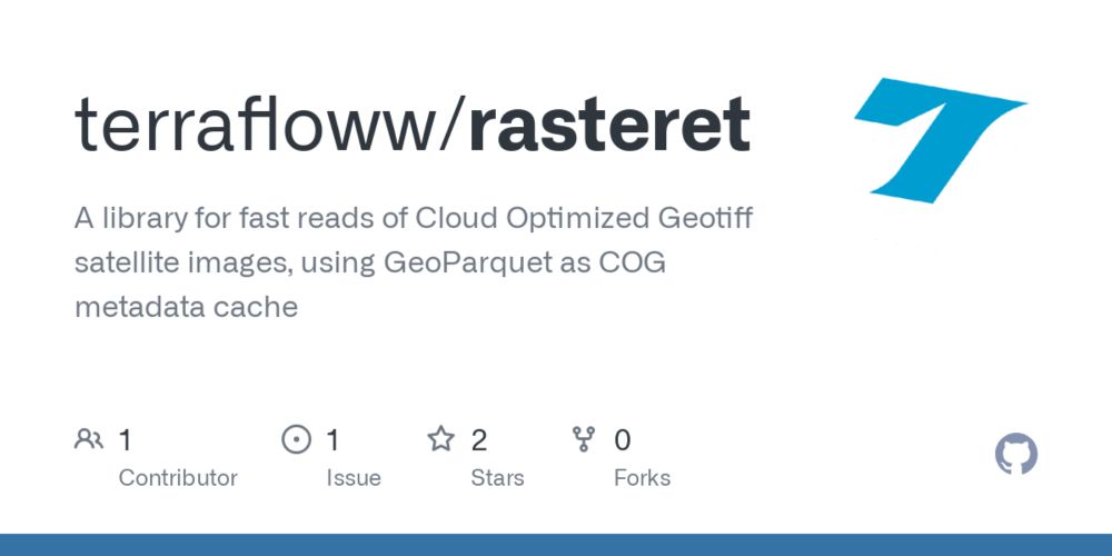
⚡️Quick stat, Rasteret library gets 1 year's worth of #landsat satellite's #NDVI time series for a small farm is less than 4 seconds!
Blog - blog.terrafloww.com/rasteret-a-l...
Code - github.com/terrafloww/r...
#geospatial
12.01.2025 17:46 — 👍 0 🔁 0 💬 0 📌 0
Thanks to @maxlenormand.bsky.social , Soumya ranjan from @developmentseed.org , my colleague Gajesh Ladhar from Satsure , for thier early feedbacks.
12.01.2025 07:34 — 👍 1 🔁 0 💬 0 📌 0
Sorry to hear about this. Take care.
10.01.2025 15:46 — 👍 0 🔁 0 💬 0 📌 0
True totally agreed that its tough. But im wondering how PyPI gets funded by donations from both community developers and companies like Meta and so on, i guess it just due to sheer numbers? Geo is pretty small compared to general Python.
09.01.2025 13:11 — 👍 1 🔁 0 💬 0 📌 0
It doesn't need to another private company setting it up and owning it. It can be truly open and community + private industry funded. Unlike PyPI which hosts full libraries, the geo dataset registry doesn't need to keep STACs or any datasets inside it. A few Postgres/ES instances might be enough.
09.01.2025 12:12 — 👍 0 🔁 0 💬 1 📌 0
I mean PyPI registry's framework/design and governance is close to what can be done for geo as well.
09.01.2025 12:02 — 👍 0 🔁 0 💬 1 📌 0
I think PyPI is interesting. Its completely funded by donations. Controlled by python software foundation. Also, since I thinking there will just be pointers to STACs and Non-STACs I don't think it will be costly to maintain.
09.01.2025 12:01 — 👍 0 🔁 0 💬 2 📌 0
Similar to PyPI, data producers can push just metadata of datasets in toml files, to a central registry. It would only contain a "summary metadata" of entire STACs, parquet/csv files, APIs like OSM. With thier total bbox, quality metrics etc. A registry like this can be more easily governed i feel?
09.01.2025 08:08 — 👍 0 🔁 0 💬 0 📌 0

Christopher Beddow on LinkedIn: #gischat #maps #api #data #geospatial | 14 comments
A universal map data API aggregator?
Does it exist?
I saw this for flight and travel APIs and some others. You can subscribe to this service, and it acts as… | 14 comments on LinkedIn
@cbed.bsky.social had put up a question on LinkedIn about finding all datasets STAC or not. And his idea was an aggregator of datasets in YAML. Similarly I feel PyPI registry is a good thing to emulate, with geopip to get data and pass it to pystac/duckdb/requests based on details sent via toml
09.01.2025 07:20 — 👍 1 🔁 0 💬 3 📌 0
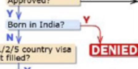
A cropping of the immigration flow chart that reads “Born in India? Y -> DENIED”
I know it shouldn’t but this bit is so petty it made me lol
03.01.2025 16:29 — 👍 24 🔁 1 💬 2 📌 1
The completely open source code of iceberg and the basic REST catalog still provides great features for most people. Read/filter, write/append cloud based data (usually parquet) using just Pyiceberg. Merge/update rows are possible via Trino/Spark engines, it should come soon to Pyiceberg as well.
17.12.2024 08:09 — 👍 1 🔁 0 💬 0 📌 0
A journey of optimization of cloud-based geospatial data processing | Hacker News
Feels good to have #geospatial blog on Hacker News front page!
Chime in, on the comments if you wish!
news.ycombinator.com/item?id=4241...
15.12.2024 17:36 — 👍 1 🔁 0 💬 0 📌 0
As I get closer to releasing the open source library which I will call, "Rasteret" , short for raster-retrieval, I reflected on the blog I published last week, and edited it to include some more details regarding compute and its code samples.
Check it out and do share your thoughts!
#geospatial
08.12.2024 13:58 — 👍 1 🔁 0 💬 0 📌 0
Could you add me please? Thanks
06.12.2024 05:22 — 👍 1 🔁 0 💬 0 📌 0
https://southbaysystems.xyz
https://youtube.com/@southbaysystems
Ph.D. Student at Berkeley AI Research | AI for Chaotic Environments and the Dual-Use Governance of AI
Sailing big waves for a job 🛰 | EO, Geospatial & Modern Slavery research @rightslab.bsky.social⚖️| FOSS4G @OSGeo/@geospatialorg| Committee @GRSG_GeolSoc | Youth4Oceans 🌊|🇷🇴 in 🇬🇧
Principle Cyber Security Industry Analyst, expert at leading Marketing, Engineering & Technology functions to deliver programs that translate strategy into actions to trigger growth for technology-led companies.
Bringing the tech thought leader community together with the coolest technology companies. Part of The Futurum Group.
Site: https://TechFieldDay.com | YouTube: https://YouTube.com/TechFieldDay | Podcast: https://podcasters.spotify.com/pod/show/techfieldday
Keynote Speaker, Technology Advocate, Author. Looking forward to a brighter future for our world!
Product Marketing Leader | Entrepreneur
Austin via Florida Panhandle
Founder & CEO DigitalSunshineSolutions.com
Founder & Cohost techaunties.com
Founder instagram.com/bigmamasbasement
Find me @gminks@mas.to
Think big. Think different. Connect all!
Better not to start, once begun better to finish.
Open-Source Software for science at Earthmover.io, built on Pangeo.io.
One of many xarray.dev core devs. https://tom-nicholas.com/
Previously dabbled in oceanography at [C]Worthy and Columbia Uni., originally did fusion plasma physics.
CTO @ Iconem
Playing with city-scale 3d scans & maps, gis, real-time rendering, OSS/open-data ❤️
activating @jochemla@mastodon.social | @jochemla.bsky.social
Advisor | Technologist | Marketer | 🌎 Geographer | Geospatial | GIS | Former ESRI Executive | Earth Champion | Meditator | Never Trump 💙
Owner of Spatial Spirits -> www.spatialspirits.com
LinkedIn -> https://www.linkedin.com/in/lindacstevens/
He/him 🏳️🌈. Research software engineer @ UC Berkeley Schmidt Center for Data Science and Environment. Open Science / open source enthusiast. Nature lover 🌱🐕🌵🦌🌼🐦. Music lover 🎶🎹🥁🎵. Tinkerer 🛠️.
github.com/mfisher87
Open Science Program Scientist at NASA HQ.
Some things I love: data, code, compute, AI, art, & open science.
More at: https://cgentemann.github.io/
All opinions here are my own.
I work on Mapillary, OpenStreetMap, Overture, computational geometry, spatial computing, GIS, and maps at Meta Reality Labs.
🇺🇸 living in 🇨🇭
Blog: https://worldbuilder.substack.com
#openstreetmap #geospatial #switzerland #ski #maps #data
Apache {DataFusion PMC}, Database Internals
Just Postgres www.crunchydata.com