Home
PING-Mapper is an open-source software for recreationg-grade sonar
🚨PINGMapper v5.0🚨
This open-source mapping utility now supports:
💧Garmin RSD AND Cerulean Omniscan 450SS svlog files!!💧
If you have and collect data with these systems, why not take a look 👀 at this open-source option?
* Please report issues on GitHub!
cameronbodine.github.io/PINGMapper/
05.07.2025 11:52 — 👍 0 🔁 0 💬 0 📌 0

Crab Pot Quest - YouTube
Interested in helping to clean up Delaware's Inland Bays? Learn how to use side-scan sonar, safely retrieve gear, and collect important data via this three-p...
Interested in hunting ghost crab traps? 🦀 Want to learn how to use fishfinders for aquatic sonar surveys? 🌊 Or learn about a really cool restoration project? 😎
We are using fishfinders to help clean up lost crab traps in Delaware's Inland Bays. Watch the "Crab Pot Quest" series now!
07.05.2025 13:01 — 👍 1 🔁 0 💬 0 📌 0

Come share your innovative #sonar techniques in fisheries research and management at #AFS155 in San Antonio, TX, August 10-14, 2025!
25.02.2025 16:37 — 👍 6 🔁 4 💬 1 📌 0
In case you missed it, v3.0 added support for sl2 and sl3 sonar logs (Lowrance, etc)!
07.01.2025 01:25 — 👍 0 🔁 0 💬 1 📌 0
YouTube video by Grant | sea saturated
How to find 100 free crab pots in a day
Grant Otto posted a fantastic video showcasing a rewarding project I have been involved w/: ghost crab pot recovery in partnership with Brittany Haywood and Delaware SeaGrant! Check out Grant’s other videos showcasing the great work we are doing in Art Trembanis #CSHEL lab! youtu.be/VFZzC-AYvng?...
02.01.2025 01:32 — 👍 0 🔁 0 💬 0 📌 0
In addition, new methods of reading data from sonar logs (recordings) result in up to a 1.3𝐱 𝐬𝐩𝐞𝐞𝐝𝐮𝐩!
Head over to GitHub to try it out! Happy ping-ing!
12.12.2024 13:16 — 👍 1 🔁 1 💬 0 📌 0
PINGMapper v3.0.0-alpha is available now! This version incorporates a new sonar log pre-processing engine called PINGVerter. PINGVerter enables compatibility with sl2 and sl3 files. PINGVerter is designed to ease adding support for new sonar data acquisition platforms and filetypes.
12.12.2024 13:16 — 👍 0 🔁 0 💬 1 📌 0

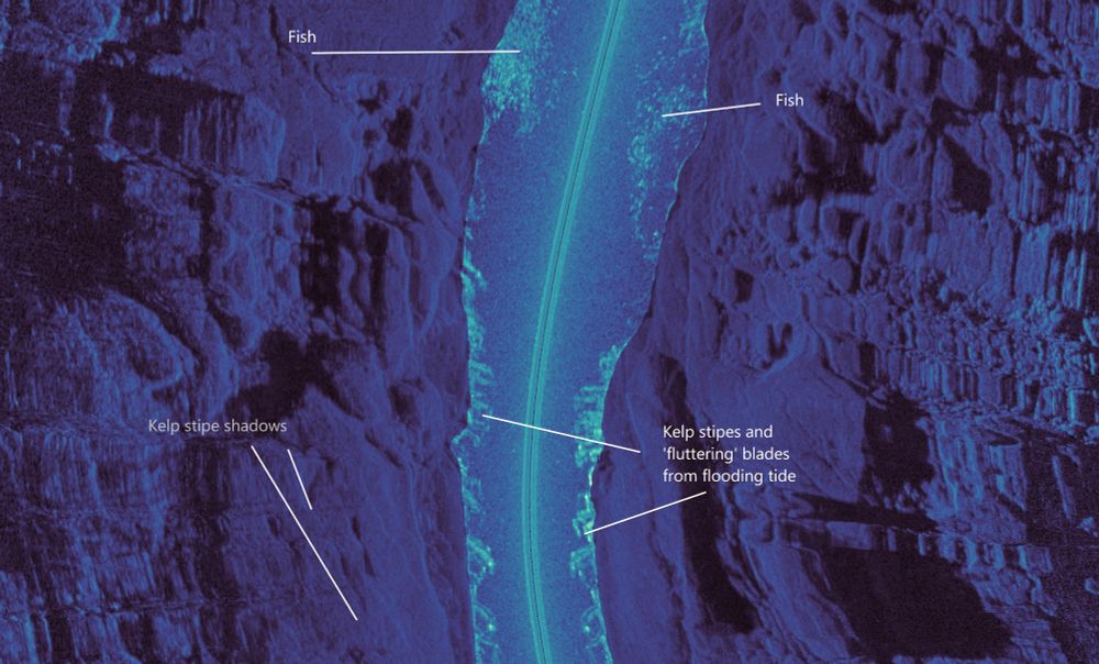
High resolution down-scan image along the transect, showing individual shoals of fish swimming above the kelp forest detected at nadir.
Having a dabble mosaicking VHF down-scan imagery along some rough ground previously mapped with the Humminbird sidescan, and processed using PINGMapper. Doing so provides a fantastic transect overview, and clearly illustrates the ground and the value that kelp cover provides for detected fish.
22.11.2024 12:15 — 👍 4 🔁 2 💬 1 📌 0

An old wooden-stocked Admiralty type anchor initially located using sidescan sonar, and later ground truthed using a towed video camera when water conditions allowed.
Sidescan verses towed video.
24.11.2024 16:08 — 👍 2 🔁 2 💬 0 📌 0

Heading filters are coming to #PINGMapper soon! You can specify the maximum heading deviation over a given distance to automatically remove bends from the mosaic. Better yet, each transect is exported to its own mosaic, allowing toggling a layer order in GIS.
25.11.2024 21:28 — 👍 1 🔁 0 💬 0 📌 0

Bug fixes, new features, & compatibility coming to an updated version (3.0??) of #PINGMapper. One is improved bankline polygon export made possible w/ shadow detection neural nets. Works on any sonar recording length. More features to come...
25.11.2024 20:37 — 👍 1 🔁 1 💬 0 📌 0
Georeferenced VHF sidescan sonar in waterfall view for quickly recording detailed water column transects with a spacial context. Here shoaling fish are seen amongst the kelp in a high energy coastal environment.
#sonar #Humminbird #PINGMapper #QGIS
@cameronbodine.bsky.social
16.11.2024 07:53 — 👍 1 🔁 1 💬 0 📌 0

I learned a lot about new applications at the “Advancing sonar techniques for use in fisheries management” symposium at #AFS154! I also shared updates to #PINGMapper.
24.09.2024 22:27 — 👍 0 🔁 0 💬 0 📌 0
We connect science and economics to inform policy that protect, restore, & conserve vital freshwater resources.
https://uwm.edu/centerforwaterpolicy/
Angler and fisheries biologist, in that order | Fish 🐟 diets, trophic ecology, #fishpuke 🤮, population dynamics, fisheries management | @afs-scicomm.bsky.social prez | he/him | views are mine
📍 northeast Minnesota
🔗 linktr.ee/kamden.glade
Love observing humanity & water's complexity | wisdom hunter | ai/ml coder/techie | founder | strategic creative | kayak freak | help clean up VA rivers | help restore wooden boats | help teach students mth/sci/eng thru blding boats #teamfish #teamkayak
Delaware's Congresswoman.
Congresswoman Sarah McBride and her congressional staff use this page to share news & services relevant to Delaware. This is her official government Bluesky page.
PhD student, Earth and Marine Sciences.
Global Hydrology Lab at University of North Carolina at Chapel Hill #EarthObservation
environmental scientist with an undiluted passion for water
Entrez dans la dimension géographique avec #ArcGIS la plateforme pour #SIG #TheScienceOfWhere #Géomatique #Géomarketing #BigData #3D #Apps
Build any application on Postgres, the "everything database". Tembo offers use case specific (vector, geospatial, timeseries, search, and more) managed Postgres, powered with extensions.
Mapbox powers navigation for people, packages, and vehicles everywhere.
www.mapbox.com
I love to go out collecting spatial information, share it via
QFieldCloud and process it in the office with my best friend @qgis
🗺️ Maps for developers: Visual tools, global data, SDK & APIs for web, mobile, and enterprise applications.
Tracking the emerging scene of geospatial foundation models: www.geospatial.fm.
NLT specializes in providing integrated consulting services with the agility and ingenuity needed for todays rapidly changing world.
Your all-in-one map builder
Geospatial entrepreneur @Geomermaids, Cambridge, MA. Data wrangler and occasional developer. Open source advocate.
Helping French companies to operate in the US.
Licensed Real Estate agent in Massachusetts.
An innovative, woman-run (@alyolli.bsky.social) map design firm staffed with a combined experience of over 30 years in the fields of cartography and GIS. https://www.tombolomapsdesign.com/