Critical fire weather conditions are not letting up in Southern California. National Weather Service Los Angeles forecasts “major” fire risk through Wednesday, Jan. 15 — another five days. #CAwx
11.01.2025 00:41 — 👍 38 🔁 16 💬 2 📌 0
@drstorminsf.bsky.social
PHD Meteorologist @ CustomWeather, marathon runner. From Cape Town, SA. Also teach meteorology at SFSU.🌈49-ers, SF Giants, Warriors FAN!
Critical fire weather conditions are not letting up in Southern California. National Weather Service Los Angeles forecasts “major” fire risk through Wednesday, Jan. 15 — another five days. #CAwx
11.01.2025 00:41 — 👍 38 🔁 16 💬 2 📌 0
This is soooo my cat, Cosmo.
07.01.2025 03:02 — 👍 1 🔁 0 💬 0 📌 0
A series of large storms in the Pacific are generating long-period swells that will create high surf conditions beginning Saturday and continue for almost a week. NWS High Surf Advisory: forecast.weather.gov/wwamap/wwatx...
20.12.2024 06:20 — 👍 11 🔁 5 💬 0 📌 0
Several storms spinning over the Pacific Ocean will push rough seas toward the California coast in the coming days. Those conditions will coincide with the annual king tides, raising the flood risk for Bay Area beaches.
12.12.2024 16:42 — 👍 13 🔁 2 💬 0 📌 2
A magnitude 6.6 earthquake just occurred seconds ago near Eureka, California in Northern California.
05.12.2024 18:53 — 👍 1 🔁 0 💬 0 📌 0


High pressure & air pollution: warmer air aloft acts like a "lid" over particulate matter pollution below combined with light wind = hazy skies and at times unhealthy for sensitive groups air quality. This is what usually triggers our Winter Spare the Air alerts #CAwx 12/3/2024
03.12.2024 22:32 — 👍 26 🔁 10 💬 3 📌 0Ubuntu 18.04 and still using it after 29 years
28.11.2024 01:40 — 👍 0 🔁 0 💬 0 📌 0
A week ago I posted the 7-day precip forecasts from the major models (
bsky.app/profile/ggwe...). Below is the amount observed vs those forecast values. My two general impressions are that the ensembles did better and the NWS Blend was too wet. I welcome other analyses.

Per NWS Monterey 12.47" over 3 days qualifies as a 1000 year event at Downtown Santa Rosa. hdsc.nws.noaa.gov/pfds/
23.11.2024 21:43 — 👍 0 🔁 0 💬 0 📌 0

Storm totals as of 10AM (60hr): Venado in Sonoma Co. at 21.72" is the highest I can find. I've had 2.92" in Sausalito.
22.11.2024 18:09 — 👍 1 🔁 0 💬 0 📌 0

Past 36-hour rainfall totals.2.40" at my place in Sausalito.
21.11.2024 18:46 — 👍 1 🔁 0 💬 0 📌 0North Bay transition from fire season to sandbags confirmed. Wx models also performing fairly well w/ placement of the long duration atmo river plume - a mostly I-80 north event. This should change for a time as higher rain rates move south later on Friday into early Saturday #CAwx 11/21/2024
21.11.2024 15:54 — 👍 21 🔁 3 💬 3 📌 0
This is the reward for putting up with “no weather” for at least 4 months every year when you live in San Francisco!
21.11.2024 17:32 — 👍 1 🔁 0 💬 0 📌 02.33” storm total in Sausalito so far.
21.11.2024 16:39 — 👍 1 🔁 0 💬 0 📌 0
Updated season-to-date rainfall across Nrn Calif. Most notable was the 4.34" at Santa Rosa, which pushed them from 46% of normal yesterday to 155% of normal today! Over the next week, a number of other sites should also reach normal. See ggweather.com/seasonal_rai...
21.11.2024 02:48 — 👍 6 🔁 1 💬 0 📌 0I find that a good red wine pairs well with an atmospheric river 🍷
21.11.2024 02:17 — 👍 1 🔁 0 💬 0 📌 0
Some perspective on this PacNW storm. The analog is that of the Columbus Day storm of 1962. During that storm, the surface pressure reached an estimated 948mb, while today's storm reached 945mb. The impact difference: today's storm stalled 200 miles off the coast, while the 1962 storm breached it.
20.11.2024 02:14 — 👍 27 🔁 9 💬 0 📌 0You are getting sleepy. 😴 #Fibonacci
20.11.2024 00:09 — 👍 112 🔁 30 💬 4 📌 2Managing people’s rainfall expectations in San Francisco tomorrow with the incoming atmospheric river 🤦🏼♂️
20.11.2024 01:04 — 👍 0 🔁 0 💬 0 📌 0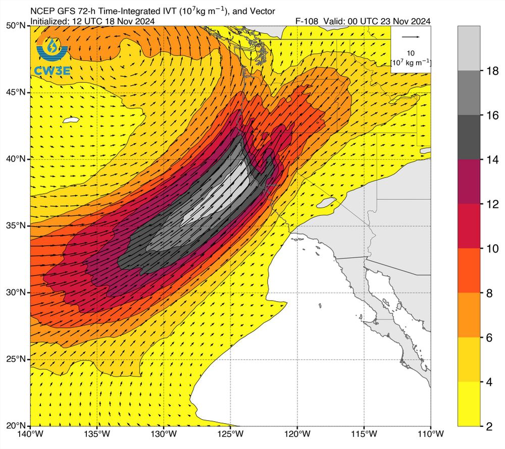
Snapshot of 3-day accumulated IVT (integrated vapor transport) along the West Coast of North America from the GFS model. It depicts extremely high 72-hr accumulated IVT values aimed at far northern California coast.
A strong, prolonged, very moist, and relatively warm #AtmosphericRiver event, in conjunction with rapidly-strengthening #BombCyclone (yes, that's the term!), will bring major rain (and, locally, wind) impacts to OR/NorCal this week. Flooding is likely. #CAwx #ORwx #CAwater [1/6]
18.11.2024 19:35 — 👍 197 🔁 49 💬 6 📌 9
If the title wasn’t up at the top of the plot I’d have said “January”…
18.11.2024 17:40 — 👍 0 🔁 0 💬 0 📌 0


Extensive rain totals aside, an aggressively deepening low brings potential for damaging wind (esp. Pac NW) and very large waves to the coast later this week. Stay tuned #CAwx 11/17/2024
18.11.2024 04:09 — 👍 54 🔁 9 💬 3 📌 0