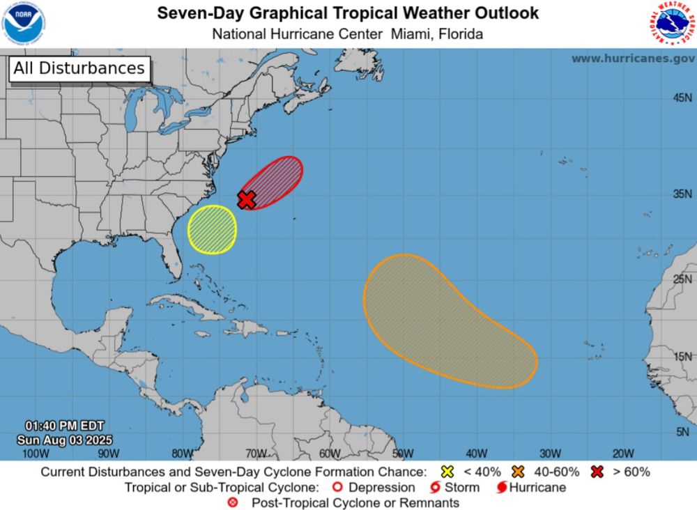
Right on time as we approach the peak months of the #Hurricane Season. Monitoring three areas across the #Atlantic. Good chance of one tropical system forming off the East Coast this week. Good news: it will move eastward out to sea. Next names: #Dexter, #Erin, #Fernand. #wx
03.08.2025 21:42 — 👍 12 🔁 5 💬 1 📌 0
"Well what if I'm a fucking talentless moron, huh? What if I suck and have nothing to say and no ability to say it? What if I follow the neighborhood dogs around and eat their succulent poops, does that make me some kind of doodoo-eater? Check and mate."
03.08.2025 16:44 — 👍 2177 🔁 328 💬 92 📌 58
We've got a banana, an orange, and an apple in the Atlantic right now. Peak hurricane season is officially here.
03.08.2025 18:55 — 👍 13 🔁 5 💬 0 📌 0
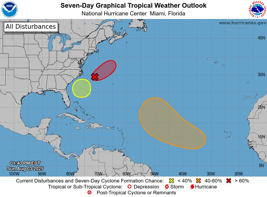
The National Hurricane Center's forecast on Sunday afternoon, showing three areas of potential development in the Atlantic.
Today is the average formation date of the Atlantic's third named storm—which we saw (Chantal) in early July.
We're likely going to stay a step ahead of an average season if one or more of these disturbances develops.
03.08.2025 18:05 — 👍 19 🔁 2 💬 1 📌 1
I think there’s a big difference between “all hope is lost” and “I have lost hope” and in climate it is really important to distinguish between the two. My personal feelings, your personal feelings are not the limits of our collective politics.
03.08.2025 12:58 — 👍 882 🔁 181 💬 19 📌 15
i saw a guy on here asking people what they thought was the GREATEST OF ALL TIME tv show and i cant think of anything better than weather channel local on the 8s
03.08.2025 11:47 — 👍 517 🔁 73 💬 27 📌 13
It's been a really bad summer for wildfire smoke in the upper midwest in the states as well, from the same group of fires in Canada.
03.08.2025 02:24 — 👍 13 🔁 2 💬 0 📌 1
Due to the higher temperatures in the latest forecast, I have decided to fire the forecasters. Thank you for your attention to this matter.
01.08.2025 19:02 — 👍 252 🔁 32 💬 13 📌 1
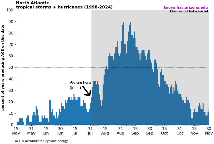
Bar chart showing the frequency of Atlantic tropical storm or hurricane activity broken down by day across 1988-2024. For a given day, the percent represents how many of those years had an active tropical storm or hurricane. For example, the percent is 19% on July 31, meaning only 19% of these years had an active storm on this date. This activity is computed via ACE, or accumulated cyclone energy, which is only calculated when a tropical storm or hurricane is active (thus excluding tropical depressions).
"Where are all the Atlantic hurricanes?"
Yes, the Atlantic hurricane season officially began on June 1. But between Jun 1 and Jul 31, it's more likely for a given day to have ZERO active tropical storms or hurricanes!
The below chart breaks it down by day. Through Jul 31, most days are below 25%!
01.08.2025 15:48 — 👍 54 🔁 19 💬 6 📌 0
The limits to [exponential] growth was published in 1972.
We didn't quite follow the exponential increase in atmospheric CO₂, but got close!
We've already completely altered the global climate.
01.08.2025 11:45 — 👍 85 🔁 37 💬 4 📌 2
New version release: NOAA/NSIDC Sea Ice Index, Version 4 | National Snow and Ice Data Center
NOAA@NSIDC is pleased to announce the release of Sea Ice Index, Version 4.
Great news and well done @nsidc.bsky.social!
"NOAA@NSIDC is pleased to announce the release of Sea Ice Index, Version 4.
This new version uses input data from the JAXA GCOM-W1 AMSR2 instrument for 1 January 2025 through forward processing."
01.08.2025 00:59 — 👍 110 🔁 21 💬 1 📌 0
Yikes. Big time flash flooding for the second time this month in NYC right now.
31.07.2025 21:42 — 👍 32 🔁 7 💬 1 📌 0
Willi Castro would have been an FA this offseason
same with Bader
same with Coloumbe
and almost all the other core guys are going to arb
so after freeing up like $40m in the trades today, they'll be able to offer arb to all their core remaining guys and keep the team intact
we *should* get to keep Ober, Jeffers, Ryan, Larnach, and Lewis now b/c of these trades
and maybe now Lewis gets a long term deal
these are great moves if you care about winning and going to the playoffs in the next 5 years
even if only as salary dumps. never mind all the prospects we got today
here's my twins trade deadline analysis to the group chat
31.07.2025 21:41 — 👍 2 🔁 0 💬 0 📌 0
Twins are going full OOTP on this trade deadline, my gosh
31.07.2025 21:39 — 👍 5 🔁 0 💬 1 📌 0
3:38pm: New Flash Flood Warning here in northern Fairfax and SW Montgomery counties where you can see heavy rain has erupted. Includes Great Falls and Potomac until 6:45pm. Rain rate of 2-3 in/hr possible. Delay travel! #cwgalert
31.07.2025 19:40 — 👍 23 🔁 7 💬 0 📌 2

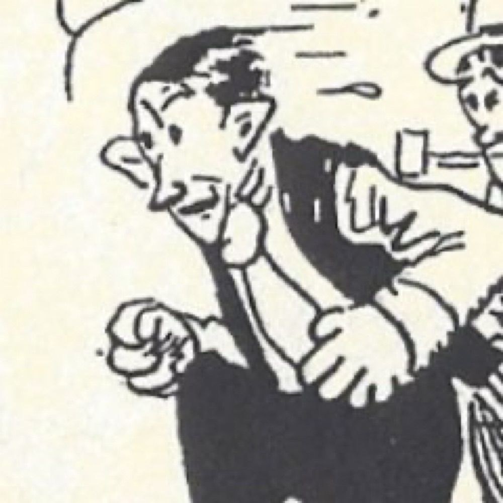
Photo of a nineteenth century French man glaring disapprovingly at some paper
The first guy who figured out that hot air holds more water vapor looked like this. We've known that warming temperatures mean heavier downpours for a very long time
31.07.2025 18:54 — 👍 187 🔁 48 💬 5 📌 1
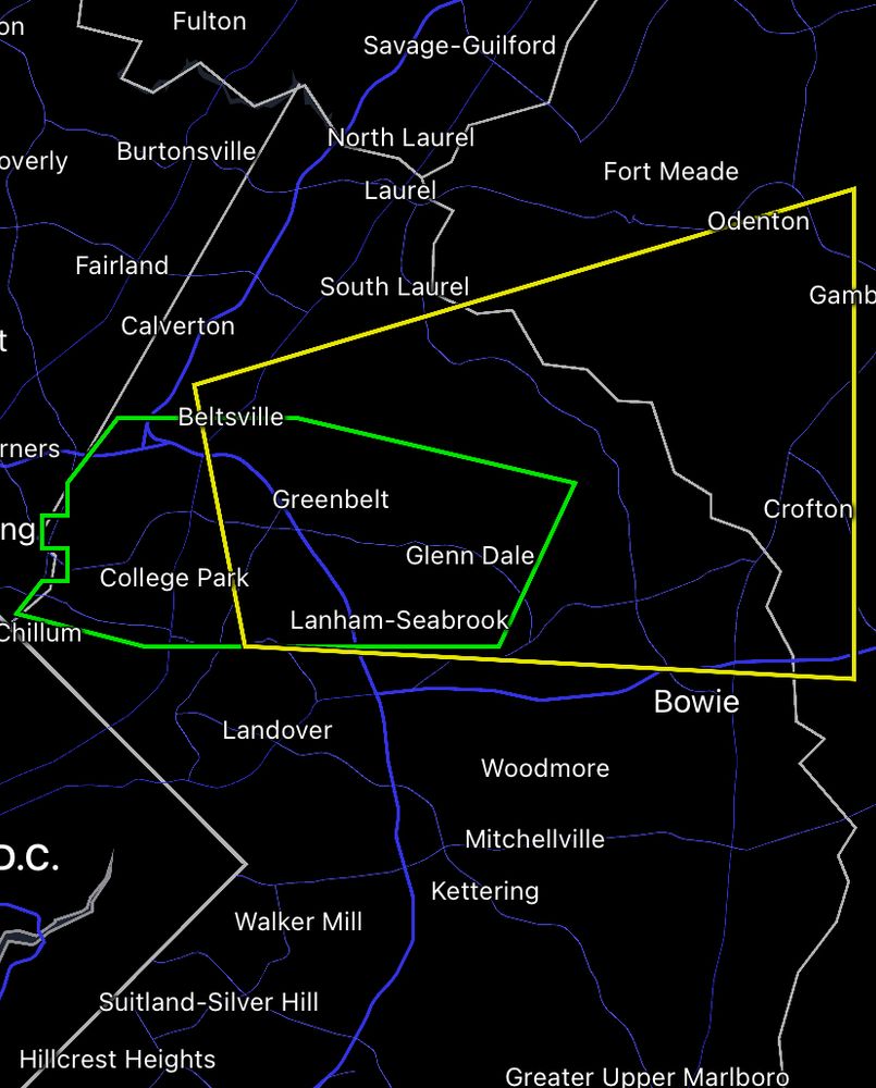
2:40pm: Overlapping Flash Flood Warning (green) and Severe T’storm Warning (yellow) from northern Prince George’s into western Anne Arundel counties. The Severe T’storm Warning, for possible damaging winds, goes til 3pm. Flash Flood Warning goes until 5:15pm but could be canceled earlier. #cwgalert
31.07.2025 18:44 — 👍 7 🔁 4 💬 0 📌 0
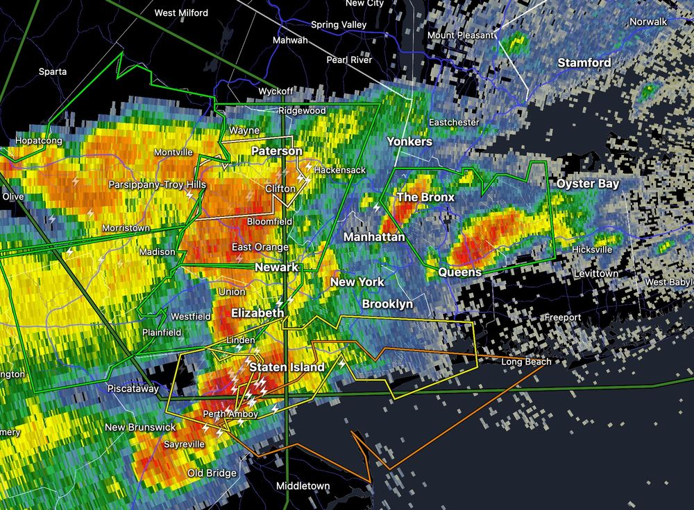
Training and anchoring of thunderstorms producing 1-3" of rain per hour along zonal surface boundary sitting over NYC and LI will quickly pose flash flooding issues, potentially significant, into the afternoon.
31.07.2025 18:51 — 👍 16 🔁 6 💬 0 📌 3
Flash floods are no joke, especially for basement apartments. In 2011, at least 11 people were found dead in them after torrential rains from Hurricane Ida fell in New York City, setting a new record of 3.15 inches in one hour: www.nytimes.com/2021/09/02/n...
31.07.2025 19:06 — 👍 47 🔁 27 💬 1 📌 1
Now at least 57 flash flood warning / thunderstorm warning / tornado warning issuances in just the past two hours alone between DC and NYC.
This is a serious ongoing event. Make sure to keep checking on your friends and neighbors.
31.07.2025 19:37 — 👍 41 🔁 22 💬 0 📌 0
Flash flood warning was just issued for Bronx/Queens.
Nearly all parts of the five boroughs will be at an extreme risk for flooding the rest of the afternoon and evening.
Get your friends and neighbors out of their basement apartments if flooding is happening.
forecast.weather.gov/wwamap/wwatx...
31.07.2025 18:57 — 👍 43 🔁 25 💬 1 📌 3
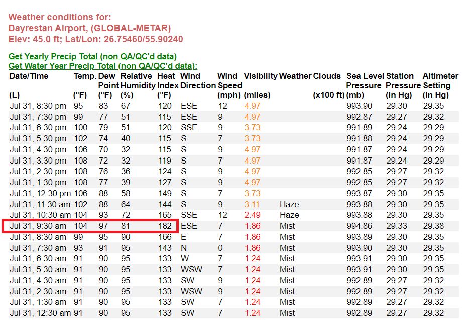
If this is accurate, it is a new world record heat index (Dayrestan Airport, Iran). 🥵
31.07.2025 18:00 — 👍 128 🔁 44 💬 21 📌 12
The synoptic-scale front is currently stationary over Long Island into I-78 in NJ. Numerous slow-moving thunderstorms moving near parallel to the front have developed. Two stationary cells over Queens & Bronx need to be monitored for potential/imminent flash flooding this afternoon.
31.07.2025 18:25 — 👍 22 🔁 6 💬 1 📌 2
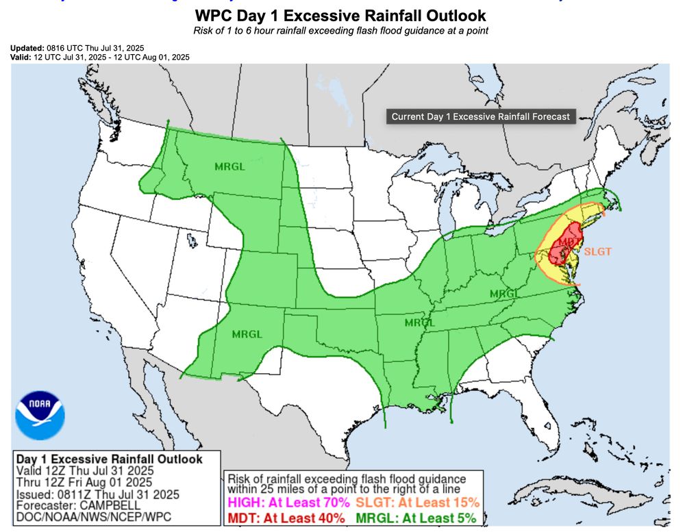
Impact potential for Moderate Risk Area: These probabilities
listed above serve as signals in ensemble guidance that highlight
the potential for significant flash flooding throughout the country,
let alone over a highly populated urban corridor. Given the
atmospheric parameters in place, it is possible that the Mid-
Atlantic I-95 corridor witnesses thunderstorms that produce
rainfall rates up to 3"/hr, with perhaps the most intense storms
potentially generating 2" rainfall totals in as little as 30
minutes. QPF may seem light at first glance given the hourly
rainfall rate potential, but this is largely due to lingering
uncertainty in the placement of the heaviest rainfall. Many
individual convective models show localized totals surpassing 5"
with even some localized maxima approaching 8". Residents in the
Mid-Atlantic should ensure they have reliable means of receiving
warnings issued by their local WFOs throughout the day and into
Thursday night.
Heads up for a potentially major flash flooding event today between DC to NYC, including Baltimore, Philadelphia, and most of New Jersey.
Rain rates of 2-3"/hour and 5-8" total are possible — even likely.
www.wpc.ncep.noaa.gov/qpf/ero.php?...
31.07.2025 09:58 — 👍 34 🔁 16 💬 0 📌 1
Per Tsunami.gov, the largest tsunami heights were:
5.7ft at Kahului, Maui
4.9ft at Hilo, HI
4.0’ at HALEIWA HI
3.7’ at Crescent City, CA.
Complete list and wave periods are linked:
www.tsunami.gov/events/PHEB/...
30.07.2025 13:42 — 👍 145 🔁 62 💬 3 📌 3
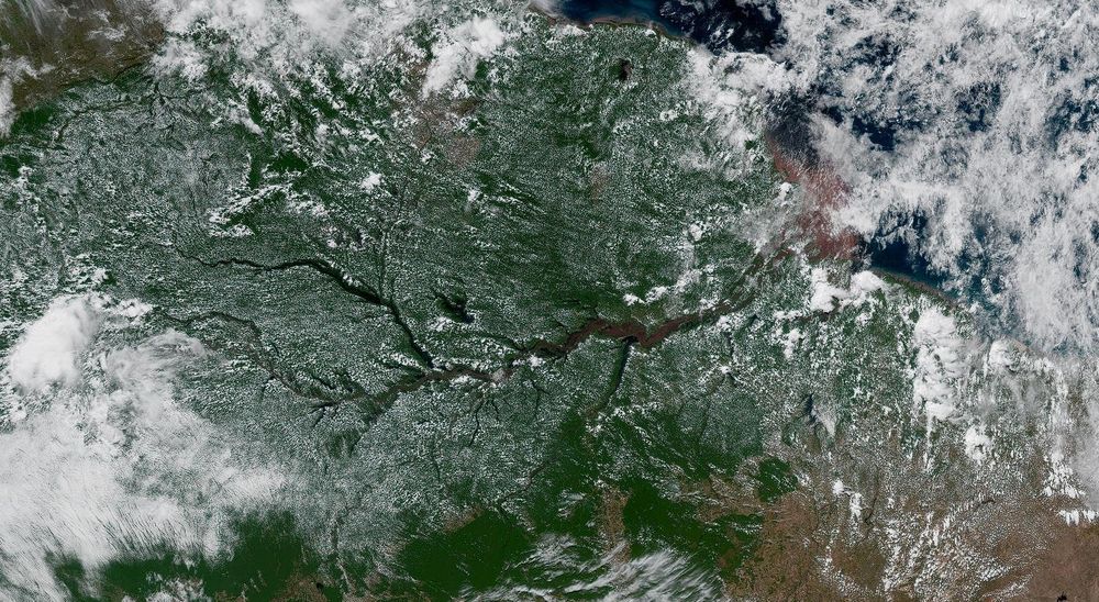
A visible satellite image of vast fields of puffy cumulus clouds over the Amazon rainforest, with cloud-free skies over the Amazon River itself where the atmosphere is more stable.
I'm filling in at work today and my brain is still in day-off mode.
I'm staring at satellite trying to jog my brain into weathering.
This 'crack' in the clouds over the Amazon is pretty neat—the atmosphere is slightly more stable over the cooler waters of the Amazon River, leaving a clearing.
30.07.2025 17:31 — 👍 35 🔁 1 💬 2 📌 0
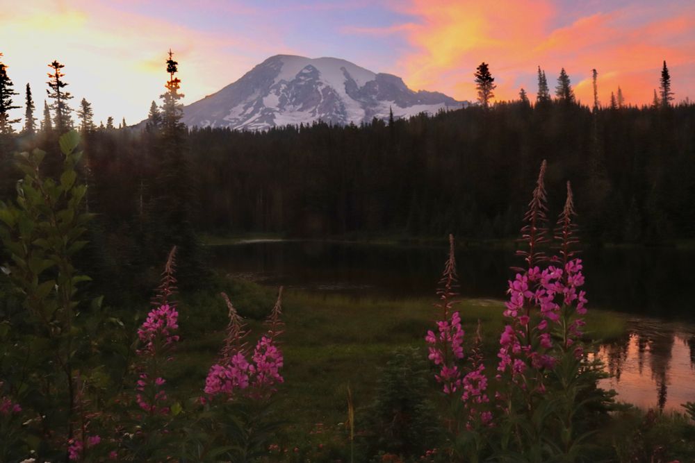
While the Ring of Fire was popping off last evening, Mount Rainier’s wilderness found another way to pop off around the same time #wawx
📍Reflection Lakes
30.07.2025 14:21 — 👍 23 🔁 3 💬 0 📌 0
A thread about the enormous benefits of federally funded science related to tsunamis. The alerting system is not something that could have been easily developed by the private sector because this is an essential service. ⬇️
30.07.2025 15:45 — 👍 37 🔁 9 💬 0 📌 0
Wow. That's quite a wave. Thankfully no damage or injuries in Hawaii or on the US west coast from it.
www.theguardian.com/us-news/2025...
30.07.2025 12:09 — 👍 24 🔁 9 💬 0 📌 0
We are the National Snow and Ice Data Center at the University of Colorado Boulder. We conduct innovative research and provide open data to understand how the frozen parts of Earth affect the rest of the planet and impact society.
"In exile, the only house is that of writing." – Adorno
Cities, Climate, Cats 🌻 Writer & comms professional 🐝 Words in LA Review of Books, Atlantic, Frieze, Art Review, Virginia Quarterly, Public Books 🌼 anandimishra.com
📩 anandimi.substack.com
CPH/colors/climate/plants
News on weather, climate, oceans, fish, satellites, research & more from NOAA Communications. Official NOAA account.
Assistant Professor, Environmental Studies, NYU
Primatologist, Author of THE ARROGANT APE
https://www.cewebb.com
Retired advocate for individuals with disabilities.
Animal welfare, history, art, cosmos.
Introvert, lover of rain, and our beautiful planet.
Elk Grove, Sacramento
“You cannot control the wind, but you can adjust your sails.”
Music , Climate Crisis Club, The Wilderness Party🌲
Freelance Journalist in Bangkok | former Reuters climate correspondent | Author of Eight Bears: Mythic Past and Imperiled Future | National Geographic Explorer | www.gloriadickie.com |
Advancing transformative climate solutions. Analysis, insight, and research on climate change from the Climate, Economics and Finance team at the World Resources Institute.
Comms Director, Stanford Woods Institute for the Environment. 👀enviro/eco/climate news, scicomms and media. Views here are my own.
Building relationships ✨ Ocean & Climate Scientist ✨ Writing, Watercoloring, Sketching ✨ Child-free, Cat-ladden ✨ Reclaiming the ✨ emoji from AI ✨ Personal Account
UBC sociologist, demographer, housing & urban regulation scholar, author, immigrant, blogs at https://homefreesociology.com/
PhD Science at University of Melbourne - passionate about the future of pencil pine and other old growth palaeoendemics. Living in Naarm, Lutruwitan at heart. Budding geographer and palaeo enthusiast 🌲🌿🔥🪨🌏🔬🏳️🌈 y’all play nice now 🙏🏼
A weekly radio podcast dedicated to bikes as transportation, at https://biketalk.org/
MaddowBlog.com
Rachel: https://bsky.app/profile/maddow.msnbc.com
Steve: https://bsky.app/profile/stevebenen.com
Chancellor's Professor
Civil and Environmental Engineering
Urban Planning and Public Policy
University of California, Irvine
floodlab.eng.uci.edu
Editor-in-Chief of @fangraphs.com, co-host of @ewpod.bsky.social
patreon.com/effectivelywild
Writer of books on Krazy Kat and zydeco and the 2005 flood and my dad’s old photos. Working on books about Bunny Matthews and Charlie Chaplin. I answer mail at MichaelTisserand.com
Climatologist, clouds, warm weather, rock and roll. You may know me from my greatest hits: Assistant State Climatologist of Colorado. Now feeling my way around consulting.
Scientist and sports fan…