Tuesday October 7, 2025 10:00PM EDT @noaa.gov @NOAASatellites view of disturbance 1 in the southern area of the Gulf of Mexico or The Bay of Campeche. #Hurricane #J1WX #TropicsWX #Tropics #TropicalWX #BlueSkyWX #WXBlueSky #WX #NOAA #Karen
08.10.2025 02:46 — 👍 0 🔁 0 💬 0 📌 0
The Democratic party is in disarray. This plays into the hands of Republicans esp MAGA. Now is the time for the dems to unite so the dems retake control via landslide elections. Violence is not the way, that just does Donald Trump a favor. Start with the farmers. #Unity🌿🫏🇺🇸 / @democrats.org
05.10.2025 19:49 — 👍 1 🔁 0 💬 0 📌 0

Eric Burris
COFFEE TALK: Tracking new Invest 95, plus our wet Sunday forecast; Join us! Discuss!
Sunday October 5, 2025: Via @EricBurrisWESH @WESH 'COFFEE TALK: Tracking new Invest 95... #Jerry #Hurricane #J1WX #TropicsWX #TropicalWX #Tropics #BlueSkyWX #WXBlueSky #WX x.com/i/broadcasts...
05.10.2025 19:40 — 👍 0 🔁 0 💬 0 📌 0
Tuesday September 30, 2025 8:00PM Northeast Fire & Ambulance: Vehicle accident Natural Bridge Rd exit from northbound I-170, Bel-Ridge 63121 #STLTRAFFIC #STL #StLouis #Missouri #STLJOE2 #MoDOT
01.10.2025 01:19 — 👍 0 🔁 0 💬 0 📌 0
Tuesday September 30, 2025 11:00AM EDT Via The Weather Channel: Humberto And Imelda Forecast To Impact Bermuda & Imelda Turns Deadly In Cuba, A Bigger Threat For Bermuda. #Hurricane #J1WX #TropicsWX #TropicalWX #Tropics #TropicalWX #WXBlueSky #WX #Bermuda #Cuba #Imelda #Humberto
30.09.2025 15:07 — 👍 0 🔁 0 💬 0 📌 0
Mon Sept 29, 2025 9:25AM EDT Via The Weather Channel: Confidence Grows In #Imelda's Upcoming Eastward Curve & #Charlestonsc Prepares...' #Hurricane #J1WX #WXBlueSky #Tropics #TropicalWX #WX weather.com/storms/hurri...
29.09.2025 13:31 — 👍 0 🔁 0 💬 0 📌 0
YouTube video by Eric Burris
TROPICAL UPDATE: Tropical Storm Humberto forms...
Wed Sept 24, 2025 5PM EDT Via @EricBurrisWESH: www.youtube.com/watch?v=NPTR... #J1WX #TropicsWX #Tropics #TropicalWX #BlueSkyWX #WXBlueSky #WX #Humberto
24.09.2025 21:07 — 👍 0 🔁 0 💬 0 📌 0

Wednesday September 24, 2025 5PM EDT: Via @noaa.gov @nhc-atlantic.extwitter.link: disturbance 1 or invest #93L is now Tropical Storm #Humberto. Please follow ➡️ nhc.noaa.gov for updates. #Hurricane #J1WX #TropicsWX #TropicalWX #Tropics #TropicalWX #TwitterWX #WXTwitter #WX #Humberto
24.09.2025 21:04 — 👍 0 🔁 0 💬 0 📌 0
Monday September 22, 2025 11:05PM St Louis Fire Department: Vehicle accident / rescue - eastbound I-70 at Kingshighway Blvd, mile marker 244.5, Penrose Park Neighborhood 63115 #STL #StLouis #Missouri #STLTRAFFIC #STLJOE2
23.09.2025 04:17 — 👍 2 🔁 0 💬 0 📌 0
Mon Sept 22, 2025 10:30PM EDT: Category 4 Typhoon Ragasa has 140 mph+ winds. Landfall expected Wed Sept 24 somewhere on Hainan Island. #Hurricane #TyphoonRagasa #J1WX #TropicsWX #Tropics #WXBlueSky #WX
23.09.2025 03:27 — 👍 0 🔁 0 💬 0 📌 0

ZCZC MIATWOAT ALL<br>TTAA00 KNHC DDHHMM<br><br>Tropical Weather Outlook<br>NWS National Hurricane Center Miami FL<br>Issued by the NWS Weather Prediction Center College Park MD<br>200 PM EDT Mon Sep 15 2025<br><br>For the North Atlantic...Caribbean Sea and the Gulf of America:<br><br>1. Central Tropical Atlantic (AL92):<br>A broad area of low pressure has formed roughly midway between the <br>Windward Islands and the coast of west Africa. This system has <br>become better organized since yesterday and is expected to move <br>through a favorable environment for further development. A <br>tropical depression or tropical storm is likely to form by the <br>middle to latter part of this week as the system moves <br>west-northwestward at 10 to 15 mph over the central tropical <br>Atlantic.<br>* Formation chance through 48 hours...medium...50 percent.<br>* Formation chance through 7 days...high...90 percent.<br><br><br><br>Forecaster Blake/Putnam<br><br><br>

Atlantic 2-Day Graphical Outlook Image

Atlantic 7-Day Graphical Outlook Image
NHC Atlantic Outlook update for Mon, 15 Sep 2025 17:45:42 UTC
Additional Details Here.
15.09.2025 18:00 — 👍 11 🔁 5 💬 0 📌 3

Monday September 15, 2025 1:45PM EDT: @noaa.gov //-// @nhc-atlc.nws-bot.us are monitoring disturbance 1 ( #Gabrielle ); has a 90% chance of development. Please follow ➡️ nhc.noaa.gov ⬅️ for updates. #Hurricane #J1WX #TropicsWX #TropicalStorm #Tropics #WXBlueSky #WX
15.09.2025 19:34 — 👍 0 🔁 0 💬 0 📌 0

Sun September 14, 2025 1:13AM EDT: @noaa.gov @nhc-atlc.nws-bot.us are monitoring disturbance 1; has a 60% chance of development. Please follow ➡️ nhc.noaa.gov ⬅️ for updates. #Hurricane #J1WX #TropicsWX #TropicalWX #Tropics #TwitterWX #WXTwitter #WX #Gabrielle
14.09.2025 06:06 — 👍 0 🔁 0 💬 0 📌 0
Monday September 8, 2025 11:58PM Northeast Fire & Ambulance: Vehicle fire eastbound I-70 at Lucas and Hunt Rd, mile marker 242, Northwoods 63121 #STL #StLouis #Missouri #STLTRAFFIC #STLJOE2
09.09.2025 05:20 — 👍 0 🔁 0 💬 0 📌 0
Monday September 8, 2025 10:55PM CDT @noaa.gov @nws.noaa.gov National Weather Service station Amarillo @ama.nws-bot.us ➡️ weather.gov/ama/ ⬅️ radars show #severe #thunderstorms & flash flooding in the #Amarillo region. #TwitterWX #WXTwitter #WX #TXwx #Texas #J3WX
09.09.2025 03:54 — 👍 0 🔁 0 💬 0 📌 0

Fri Sep 5, 2025 7:13PM EDT: @noaa.gov @nhc-atlc.nws-bot.us are monitoring disturbance 1; has 60% chance of development. Yesterday a 90% chance.➡️ nhc.noaa.gov ⬅️ for updates. #Hurricane #J1WX #TropicsWX #TropicalWX #Tropics #TropicalWX #BlueSkyWX #WXBlueSky #WX #Gabrielle
06.09.2025 00:05 — 👍 0 🔁 0 💬 0 📌 0

ZCZC MIATWOAT ALL<br>TTAA00 KNHC DDHHMM<br><br>Tropical Weather Outlook<br>NWS National Hurricane Center Miami FL<br>800 PM EDT Fri Sep 5 2025<br><br>For the North Atlantic...Caribbean Sea and the Gulf of America:<br><br>1. Tropical Atlantic (AL91):<br>Shower and thunderstorm activity remains limited in association with <br>a tropical wave over the central tropical Atlantic. A drier air mass <br>is limiting the potential for development over the next couple of <br>days, and environmental conditions will remain only marginally <br>favorable thereafter. A tropical depression could form during the <br>early to middle part of next week as the system moves westward at <br>around 10 mph across the central tropical Atlantic. This system is <br>likely to be near the Lesser Antilles by the middle to latter part <br>of next week, and interests there should monitor its progress.<br>* Formation chance through 48 hours...low...30 percent. <br>* Formation chance through 7 days...medium...60 percent.<br><br><br><br>Forecaster Kelly<br><br><br>

Atlantic 2-Day Graphical Outlook Image

Atlantic 7-Day Graphical Outlook Image
NHC Atlantic Outlook update for Fri, 05 Sep 2025 23:14:02 UTC
Additional Details Here.
05.09.2025 23:20 — 👍 10 🔁 6 💬 0 📌 1
Wednesday September 3, 2025 8:12PMPM CDT @noaa.gov @nws.noaa.gov National Weather Service station Wichita @ict.nws-bot.us ➡️ weather.gov/ict/ ⬅️ radars show #severe #thunderstorms in south central / southwest #Kansas. #BlueSkyWX #WXBlueSky #WX #KSwx #Kansas #J3WX
04.09.2025 01:11 — 👍 0 🔁 0 💬 0 📌 0

Tue Sep 2, 2025: Joint Typhoon Warning Center map for Category 1 Hurricane Kiko. Via #Hawaii News Now' It remains too early to tell what, if any, impacts this system might have on the local weather. #Hurricane #J1WX #TropicsWX #Tropics #TropicalWX #WXBlueSky #WX www.metoc.navy.mil/jtwc/jtwc.html
03.09.2025 00:44 — 👍 0 🔁 0 💬 0 📌 0
Tuesday September 2, 2025: Weather Channel Meteorologist Jim Cantore explains disturbance 1 off Cabo Verde Islands 'Tropical Storm Gabrielle Could Form Later This Week, But Could Recurve In The Atlantic Again' #Hurricane #J1WX #TropicsWX #TropicalWX #Tropics #BlueSkyWX #WXBlueSky #WX #Gabrielle
02.09.2025 13:09 — 👍 0 🔁 0 💬 0 📌 0
Monday September 1, 2025 10:55PM Robertson Fire Protection District: Vehicle accident eastbound Mo Route 370 east of Discovery Bridge, Bridgeton 63044 #STLTRAFFIC #STL #StLouis #Missouri #STLJOE2
02.09.2025 04:11 — 👍 0 🔁 0 💬 0 📌 0
Monday September 1, 2025 10:34PM Mehlville Fire Protection District: Brush fire northbound I-55 at Meramec Bottom Rd, mile marker 193.5, Unincorporated South County 63129 #STLTRAFFIC #STL #StLouis #Missouri #STLJOE2
02.09.2025 03:52 — 👍 0 🔁 0 💬 0 📌 0
The Netflix documentary series on Katrina does an amazing job of covering all the facets of the disaster. Credit to Soledad O’Brien for calling out the media’s hypocrisy of coverage. #Netflix #Katrina
02.09.2025 02:31 — 👍 13 🔁 3 💬 1 📌 1
Monday September 1, 2025 10:34PM Pacific Fire Protection District: Vehicle rescue /into building - BP 1692 W Osage St, west of Viaduct St, Pacific 63069 #STLTRAFFIC #STL #StLouis #Missouri #STLJOE2
02.09.2025 03:43 — 👍 0 🔁 0 💬 0 📌 0
Monday September 1, 2025 10:07PM Fenton Fire Protection District: Water rescue / disabled boat on Meramec River - Valley Park boat ramp for Valley Park Fire, George Winter Park boat ramp for Fenton Fire, Greentree Park boat ramp for Kirkwood Fire. #STL #StLouis #Missouri #STLJOE2
02.09.2025 03:32 — 👍 0 🔁 0 💬 0 📌 0
Saturday August 30 2025 9:30PM Maplewood Fire Department: Commercial structure fire Asador Del Sur 7322 Manchester Rd, cross street Oakview Terrace, Maplewood 63143 #STL #StLouis #Missouri #STLJOE2
31.08.2025 02:50 — 👍 1 🔁 1 💬 0 📌 0
Friday August 29 2025 9:05PM CDT @noaa.gov @nws.noaa.gov National Weather Service station Amarillo @ama.nws-bot.us ➡️ weather.gov/ama/ ⬅️ radars show a #severe thunderstorm in the #Amarillo region & NWS warnings of heavy rain & flooding . #TwitterWX #WXTwitter #WX #TXwx #J3WX #Texas
30.08.2025 02:05 — 👍 0 🔁 0 💬 0 📌 0
Thursday August 28 2025 10:15PM Ladue Fire Department & Ladue Police Department: Vehicle accident eastbound I-64 between Clayton Rd & McKnight Rd, mile marker 30, Ladue 63124 #STL #StLouis #Missouri #STLTRAFFIC #STLJOE2
29.08.2025 03:38 — 👍 1 🔁 0 💬 0 📌 0
Tuesday August 26 2025 10:18PM CDT @noaa.gov @nws.noaa.gov National Weather Service station Amarillo @ama.nws-bot.us ➡️ weather.gov/ama/ ⬅️ radars show a #severe thunderstorm & #tornado warning in the Oklahoma panhandle. #TwitterWX #WXTwitter #WX #OKwx #J3WX
28.08.2025 03:17 — 👍 0 🔁 0 💬 0 📌 0
Wednesday August 27 2025 9:55PM St Louis Fire Department: Vehicle accident eastbound I-64 at Hampton, mile marker 35.5, 63110 #STL #StLouis #Missouri #STLTRAFFIC #STLJOE2
28.08.2025 03:09 — 👍 0 🔁 0 💬 0 📌 0
Am a leader of a small group of LGBT 🏳️🌈 🏳️⚧️ community that a suffering in a homophobic refugee camp, please visit our website and please support our struggle 👉🏻
https://gofund.me/95ed96e1
🦋 30 + They\She + Christian + gamer + content creator + Caffeine Gremlin + Animal lover + Adhd + Cptsd + Turner Syndrome 🦋
https://linktr.ee/AkaiEmberwing
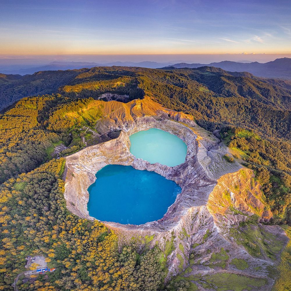
Some of the most mesmerizing wallpapers on the internet.
Sharing beautiful images of our world to open our mind.
🔵 BLUEDOT in deep red Louisiana
Old enough to know better than the bullshit they’re pushing. We have fought the fight against fascism multiple times, I’m hoping it won’t take a war this time 😎✌️
Family, Friends, Safety - All in One Place
Unofficial bot sharing alerts from National Hurricane Center - Atlantic.
This account is not monitored. Contact @wandrme.paxex.aero if needed.
transitioning away from twitter/x. Please follow!
Unofficial bot sharing alerts from NWS Amarillo TX.
This account is not monitored. Contact @wandrme.paxex.aero if needed.
Unofficial bot sharing alerts from NWS Las Vegas NV.
This account is not monitored. Contact @wandrme.paxex.aero if needed.
Unofficial bot sharing alerts from NWS Dodge City KS.
This account is not monitored. Contact @wandrme.paxex.aero if needed.
Unofficial bot sharing alerts from NWS Wilmington OH (including Dayton and the surrounding areas).
This account is not monitored. Contact @wandrme.paxex.aero if needed.
Unofficial bot sharing alerts from NWS Milwaukee/Sullivan WI.
This account is not monitored. Contact @wandrme.paxex.aero if needed.
Unofficial bot sharing alerts from NWS Quad Cities IA/IL.
This account is not monitored. Contact @wandrme.paxex.aero if needed.
Unofficial bot sharing alerts from NWS Wakefield VA, including Newport News, Richmond, and Norfolk areas
This account is not monitored. Contact @wandrme.paxex.aero if needed.
Unofficial bot sharing alerts from NWS Blacksburg VA.
This account is not monitored. Contact @wandrme.paxex.aero if needed.