OOPS! The offer you're looking for has expired.
Michael ~ fnkpp.com/SFMich
Billy ~ fnkpp.com/SFBill
Art ~ fnkpp.com/SFTerr
#Ad #HotTopic #ScareFair #Horror #FPN #FunkoPOPNews #Funko #FunkoPOP
07.10.2025 21:26 — 👍 2 🔁 1 💬 0 📌 0

Are you ready for Hot Topic’s Scare Fair? Here’s your early links! Expect them to go live .. tomorrow! In stores and online .. 9AM PT most likely ~
Jason ~ fnkpp.com/SFJaso
Buffalo ~ fnkpp.com/SFBuff
Captain ~ fnkpp.com/SFSpau
#Ad #HotTopic #ScareFair #Horror #FPN #FunkoPOPNews #Funko
07.10.2025 21:26 — 👍 2 🔁 1 💬 1 📌 0
AKQ issues Area Forecast Discussion (AFD) at Oct 7, 3:33 PM EDT
at Tue, 07 Oct 2025 19:33:52 +0000 via IEMbot
Additional Details Here.
07.10.2025 19:47 — 👍 1 🔁 1 💬 0 📌 0

Want to play a game? 🚲 Hot Topic officially reveals their Scare Fair exclusive Billy the Puppet Funko POP! Stay tuned tomorrow ~
Linky ~ fnkpp.com/HT
#Ad #BillyThePuppet #Jigsaw #Saw #FPN #FunkoPOPNews #Funko #POP #FunkoPOP
07.10.2025 19:58 — 👍 3 🔁 1 💬 0 📌 0
AKQ issues Hazardous Weather Outlook (HWO) at Oct 7, 3:48 PM EDT ...MODERATE RIP CURRENT RISK IN EFFECT THROUGH WEDNESDAY EVENING... via IEMbot
Additional Details Here.
07.10.2025 20:06 — 👍 1 🔁 1 💬 0 📌 0

Yay or nay? Disney buys the rights to Impossible Creatures! Expect to see a film in the future! #Disney #ImpossibleCreatures #FPN #FunkoPOPNews
07.10.2025 20:29 — 👍 2 🔁 1 💬 0 📌 0

ZCZC MIATWOAT ALL<br>TTAA00 KNHC DDHHMM<br><br>Tropical Weather Outlook<br>NWS National Hurricane Center Miami FL<br>Issued by the NWS Weather Prediction Center College Park MD<br>200 PM EDT Tue Oct 7 2025<br><br>For the North Atlantic...Caribbean Sea and the Gulf of America:<br><br>Active Systems:<br>The National Hurricane Center is issuing advisories on Tropical <br>Storm Jerry, located in the central Tropical Atlantic.<br><br>1. Southwestern Gulf:<br>A trough of low pressure located over the Yucatan Peninsula is <br>producing a large area of disorganized showers and thunderstorms. <br>This system is expected to emerge over the Bay of Campeche later <br>today, and some slow development is possible before it moves inland <br>over southern Mexico late Wednesday or early Thursday. Regardless <br>of development, areas of heavy rain and gusty winds are likely <br>across portions of the Yucatan Peninsula, Belize, and southern <br>Mexico during the next couple of days.<br>* Formation chance through 48 hours...low...10 percent.<br>* Formation chance through 7 days...low...10 percent.<br><br><br><br>Public Advisories on Tropical Storm Jerry are issued under WMO <br>header WTNT35 KNHC and under AWIPS header MIATCPAT5.<br>Forecast/Advisories on Tropical Storm Jerry are issued under WMO <br>header WTNT25 KNHC and under AWIPS header MIATCMAT5.<br><br><br>Forecaster Roth/Bann<br><br><br>

Atlantic 2-Day Graphical Outlook Image

Atlantic 7-Day Graphical Outlook Image
NHC Atlantic Outlook update for Tue, 07 Oct 2025 20:33:15 UTC
Additional Details Here.
07.10.2025 20:40 — 👍 9 🔁 2 💬 0 📌 0

000WTNT35 KNHC 072033TCPAT5 BULLETINTropical Storm Jerry Advisory Number 2NWS National Hurricane Center Miami FL AL102025500 PM AST Tue Oct 07 2025 ...TROPICAL STORM WATCHES ISSUED FOR PORTIONS OF THE NORTHERNLEEWARD ISLANDS... SUMMARY OF 500 PM AST...2100 UTC...INFORMATION----------------------------------------------LOCATION...12.0N 46.4WABOUT 1190 MI...1920 KM ESE OF THE NORTHERN LEEWARD ISLANDSMAXIMUM SUSTAINED WINDS...50 MPH...85 KM/HPRESENT MOVEMENT...W OR 280 DEGREES AT 23 MPH...37 KM/HMINIMUM CENTRAL PRESSURE...1003 MB...29.62 INCHES WATCHES AND WARNINGS--------------------CHANGES WITH THIS ADVISORY: The government of Antigua and Barbuda has issued a Tropical StormWatch for Barbuda and Anguilla. The government of France hasissued a Tropical Storm Watch for St. Barthelemy and St. Martin.The government of Sint Maarten has issued a Tropical Storm Watchfor Sint Maarten. SUMMARY OF WATCHES AND WARNINGS IN EFFECT: A Tropical Storm Watch is in effect for...* Barbuda and Anguilla* St. Barthelemy and St. Martin* Sint Maarten Interests elsewhere in the northern Leeward Islands, and theBritish and U.S. Virgin Islands should monitor the progress ofJerry. For storm information specific to your area, please monitorproducts issued by your national meteorological service. DISCUSSION AND OUTLOOK----------------------At 500 PM AST (2100 UTC), the center of Tropical Storm Jerry was located near latitude 12.0 North, longitude 46.4 West. Jerry is moving toward the west near 23 mph (37 km/h). A decrease in forward speed and a turn to the west-northwest is expected during the next couple of days. On the forecast track, the core of the system is expected to be near or to the north of the northern Leeward Islands late Thursday and Friday. Maximum sustained winds are near 50 mph (85 km/h) with higher gusts.Steady strengthening is forecast, and Jerry is expected to become ahurricane in a day or so. Tropical-storm-force winds extend outward up to 140 miles (220 km)from the center. The estimated minimum central pressure is 1003 mb (29.62 inches). HAZARDS AFFECTING LAND----------------------Key messages for Tropical Storm Jerry can be found in the TropicalCyclone Discussion under AWIPS header MIATCDAT5 and WMO headerWTNT45 KNHC. WIND: Tropical storm conditions are possible in portions of thenorthern Leeward Islands late Thursday and Friday, where TropicalStorm Watches have been issued. RAINFALL: On Thursday, 2 to 4 inches of rain are expected across the Leeward Islands due to Jerry. This rainfall brings a risk of flash flooding, especially in areas of higher terrain. For a complete depiction of forecast rainfall and flash flooding associated with Priscilla, please see the National Weather Service Storm Total Rainfall Graphic, available at hurricanes.gov/graphics_al5.shtml?rainqpf SURF: Swells generated by Jerry are expected to reach the LeewardIslands on Thursday. These swells are likely to causelife-threatening surf and rip current conditions. Please consultproducts from your local weather office. A depiction of rip current risk for the United States can be foundat: hurricanes.gov/graphics_at5.shtml?ripCurrents NEXT ADVISORY-------------Next intermediate advisory at 800 PM AST.Next complete advisory at 1100 PM AST. $$Forecaster Cangialosi

Tropical Storm Jerry 5-Day Uncertainty Track Image

Tropical Storm Jerry 34-Knot Wind Speed Probabilities
Atlantic Tropical Storm Jerry Advisory Number 2 issued at Tue, 07 Oct 2025 20:33:12 +0000
...TROPICAL STORM WATCHES ISSUED FOR PORTIONS OF THE NORTHERN LEEWARD ISLANDS...
Additional Details Here.
07.10.2025 20:40 — 👍 15 🔁 7 💬 1 📌 0

First peek at some of the new Wicked: For Good popcorn buckets! #Popcorn #Wicked #WickedForGood #FPN #FunkoPOPNews
07.10.2025 20:47 — 👍 4 🔁 1 💬 0 📌 0
We busted a major drug trafficking ring in Central New York.
17 individuals have been indicted, and we recovered over 23 pounds of fentanyl, 12 pounds of methamphetamine, and nearly four pounds of cocaine.
We'll continue to combat the opioid crisis and protect New Yorkers.
07.10.2025 20:52 — 👍 364 🔁 69 💬 25 📌 5

First look! Charizard! Rawrrr check out the new Pokemon Center exclusive Pearlescent Charizard Funko POP! #Pokemon #Charizard #FPN #FunkoPOPNews #Funko #FunkoPOP
07.10.2025 19:13 — 👍 5 🔁 2 💬 0 📌 0
AKQ issues Area Forecast Discussion (AFD) at Oct 7, 3:19 PM EDT
at Tue, 07 Oct 2025 19:19:46 +0000 via IEMbot
Additional Details Here.
07.10.2025 19:26 — 👍 1 🔁 1 💬 0 📌 0

* WHAT...South winds 15 to 20 kt with gusts up to 25 kt and waves
1 to 3 ft expected.
* WHERE...Chesapeake Bay from Smith Point to Windmill Point VA.
* WHEN...From 8 PM this evening to 7 AM EDT Wednesday.
* IMPACTS...Conditions will be hazardous to small craft.
Small Craft Advisory issued October 7 at 3:24PM EDT until October 8 at 7:00AM EDT by NWS Wakefield VA
Additional Details Here.
07.10.2025 19:30 — 👍 1 🔁 1 💬 0 📌 0

Now live! Chill out ~ the new Marvel Legends Ice Man action figure, available at both EE and Amazon below!
EE ~ fnkpp.com/EELeg
Amzn ~ fnkpp.com/AmLeg
#Ad #FPN #FunkoPOPNews #Marvel #MarvelLegends #Hasbro
07.10.2025 18:25 — 👍 3 🔁 1 💬 0 📌 0

GameStop announces their Pokemon Legends Z-A midnight release ~ with tote bag and giveaways at participating stores! #Pokemon #PokemonLegendsZA #FPN #FunkoPOPNews
07.10.2025 17:35 — 👍 2 🔁 1 💬 0 📌 0
ZCZC MIATWOAT ALL<br>TTAA00 KNHC DDHHMM<br><br>Tropical Weather Outlook<br>NWS National Hurricane Center Miami FL<br>Issued by the NWS Weather Prediction Center College Park MD<br>200 PM EDT Tue Oct 7 2025<br><br>For the North Atlantic...Caribbean Sea and the Gulf of America:<br><br>Active Systems:<br>The National Hurricane Center is issuing advisories on Tropical <br>Storm Jerry, located in the central Tropical Atlantic.<br><br>1. Southwestern Gulf:<br>A trough of low pressure located over the Yucatan Peninsula is <br>producing a large area of disorganized showers and thunderstorms. <br>This system is expected to emerge over the Bay of Campeche later <br>today, and some slow development is possible before it moves inland <br>over southern Mexico late Wednesday or early Thursday. Regardless <br>of development, areas of heavy rain and gusty winds are likely <br>across portions of the Yucatan Peninsula, Belize, and southern <br>Mexico during the next couple of days.<br>* Formation chance through 48 hours...low...10 percent.<br>* Formation chance through 7 days...low...10 percent.<br><br><br><br>Public Advisories on Tropical Storm Jerry are issued under WMO <br>header WTNT35 KNHC and under AWIPS header MIATCPAT5.<br>Forecast/Advisories on Tropical Storm Jerry are issued under WMO <br>header WTNT25 KNHC and under AWIPS header MIATCMAT5.<br><br><br>Forecaster Roth/Bann<br><br><br>

Atlantic 2-Day Graphical Outlook Image

Atlantic 7-Day Graphical Outlook Image
NHC Atlantic Outlook update for Tue, 07 Oct 2025 17:37:47 UTC
Additional Details Here.
07.10.2025 17:40 — 👍 3 🔁 2 💬 0 📌 0

First look! Funko Shop exclusive P!NK w/ ChainSaw POP! Coming soon to the link below ~
Linky ~ fnkpp.com/FS
#Ad #Pink #FPN #FunkoPOPNews #Funko #FunkoPOP
07.10.2025 18:04 — 👍 5 🔁 1 💬 0 📌 0
AKQ issues Area Forecast Discussion (AFD) at Oct 7, 1:59 PM EDT
at Tue, 07 Oct 2025 17:59:32 +0000 via IEMbot
Additional Details Here.
07.10.2025 18:07 — 👍 1 🔁 1 💬 0 📌 0


Rebecca Ferguson will return as Lady Jessica in ‘DUNE: PART 3’
“I don’t have a big part in this one, [she’s] just barely in the book. I’m not sure I was supposed to be in it and Denis had a little idea. The script is phenomenal”
(Source: www.indiewire.com/features/int...)
07.10.2025 16:00 — 👍 97 🔁 4 💬 1 📌 3
Rebecca Ferguson will return as Lady Jessica in ‘DUNE: PART 3’
“I don’t have a big part in this one, [she’s] just barely in the book. I’m not sure I was supposed to be in it and Denis had a little idea. The script is phenomenal”
(Source: www.indiewire.com/features/int...)
07.10.2025 16:00 — 👍 275 🔁 17 💬 0 📌 15
Yay or nay? Funko announces Kiguzoomies, part of their new premium blind box collectibles line!
#Kiguzoomies #BlindBox #Mystery #FPN #FunkoPOPNews #Funko
07.10.2025 16:52 — 👍 3 🔁 1 💬 0 📌 0
Full reveal for the new Funko Fun Squad! Premium mystery collectibles featuring Freddy and Franny! #FunSquad #Mystery #BlindBox #FPN #FunkoPOPNews #Funko
07.10.2025 16:55 — 👍 2 🔁 1 💬 0 📌 0

It has begun ~ hope you have good luck out there finding Metal Sonic 3.0! #MetalSonic #FPN #FunkoPOPNews #Funko #FunkoPOP
07.10.2025 17:09 — 👍 2 🔁 1 💬 0 📌 0
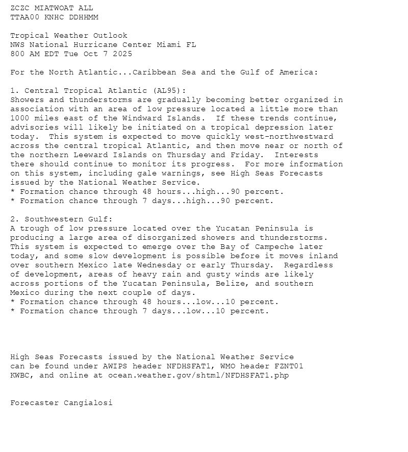
ZCZC MIATWOAT ALL<br>TTAA00 KNHC DDHHMM<br><br>Tropical Weather Outlook<br>NWS National Hurricane Center Miami FL<br>800 AM EDT Tue Oct 7 2025<br><br>For the North Atlantic...Caribbean Sea and the Gulf of America:<br><br>1. Central Tropical Atlantic (AL95):<br>Showers and thunderstorms are gradually becoming better organized in <br>association with an area of low pressure located a little more than <br>1000 miles east of the Windward Islands. If these trends continue, <br>advisories will likely be initiated on a tropical depression later <br>today. This system is expected to move quickly west-northwestward <br>across the central tropical Atlantic, and then move near or north of <br>the northern Leeward Islands on Thursday and Friday. Interests <br>there should continue to monitor its progress. For more information <br>on this system, including gale warnings, see High Seas Forecasts <br>issued by the National Weather Service.<br>* Formation chance through 48 hours...high...90 percent.<br>* Formation chance through 7 days...high...90 percent.<br><br>2. Southwestern Gulf:<br>A trough of low pressure located over the Yucatan Peninsula is <br>producing a large area of disorganized showers and thunderstorms. <br>This system is expected to emerge over the Bay of Campeche later <br>today, and some slow development is possible before it moves inland <br>over southern Mexico late Wednesday or early Thursday. Regardless <br>of development, areas of heavy rain and gusty winds are likely <br>across portions of the Yucatan Peninsula, Belize, and southern <br>Mexico during the next couple of days.<br>* Formation chance through 48 hours...low...10 percent.<br>* Formation chance through 7 days...low...10 percent.<br><br><br><br><br>High Seas Forecasts issued by the National Weather Service<br>can be found under AWIPS header NFDHSFAT1, WMO header FZNT01 <br>KWBC, and online at ocean.weather.gov/shtml/NFDHSFAT1.php<br><br><br>Forecaster Cangialosi<br><br><br>

Atlantic 2-Day Graphical Outlook Image

Atlantic 7-Day Graphical Outlook Image
NHC Atlantic Outlook update for Tue, 07 Oct 2025 15:05:16 UTC
Additional Details Here.
07.10.2025 15:10 — 👍 5 🔁 1 💬 0 📌 0

000WTNT35 KNHC 071504 CCATCPAT5 BULLETINTropical Storm Jerry Advisory Number 1...CorrectedNWS National Hurricane Center Miami FL AL1020251100 AM AST Tue Oct 07 2025Corrected link to the rip current map in the hazard section...TROPICAL STORM JERRY FORMS OVER THE TROPICAL CENTRAL ATLANTIC......THE TENTH NAMED STORM OF THE SEASON... SUMMARY OF 1100 AM AST...1500 UTC...INFORMATION-----------------------------------------------LOCATION...11.5N 44.6WABOUT 1315 MI...2120 KM ESE OF THE NORTHERN LEEWARD ISLANDSMAXIMUM SUSTAINED WINDS...45 MPH...75 KM/HPRESENT MOVEMENT...W OR 280 DEGREES AT 24 MPH...39 KM/HMINIMUM CENTRAL PRESSURE...1006 MB...29.71 INCHES WATCHES AND WARNINGS--------------------There are no coastal watches or warnings in effect.Interests in the northern Leeward Islands should monitor theprogress of Jerry as Tropical Storm Watches could be requiredlater today or tonight. DISCUSSION AND OUTLOOK----------------------At 1100 AM AST (1500 UTC), the center of the newly formed Tropical Storm Jerry was located near latitude 11.5 North, longitude 44.6 West. Jerry is moving toward the west near 24 mph (39 km/h). A decrease in forward speed and a turn to the west-northwest is expected during the next couple of days. On the forecast track, the core of the system is expected to be near or to the north of the northern Leeward Islands late Thursday and Friday. Maximum sustained winds are near 45 mph (75 km/h) with higher gusts.Steady strengthening is forecast, and Jerry is expected to become a hurricane in a day or two. Tropical-storm-force winds extend outward up to 140 miles (220 km)from the center. The estimated minimum central pressure is 1006 mb (29.71 inches). HAZARDS AFFECTING LAND----------------------Key messages for Tropical Storm Jerry can be found in the Tropical Cyclone Discussion under AWIPS header MIATCDAT5 and WMO header WTNT45 KNHC.SURF: Swells generated by Jerry are expected to reach the Leeward Islands on Thursday. These swells are likely to cause life-threatening surf and rip current conditions. Please consultproducts from your local weather office. A depiction of rip current risk for the United States can be foundat: hurricanes.gov/graphics_at5.shtml?ripCurrents NEXT ADVISORY-------------Next complete advisory at 500 PM AST. $$Forecaster Cangialosi

Tropical Storm Jerry 5-Day Uncertainty Track Image

Tropical Storm Jerry 34-Knot Wind Speed Probabilities
Atlantic Tropical Storm Jerry Advisory Number 1...corrected (corrected) issued at Tue, 07 Oct 2025 15:04:59 +0000
...TROPICAL STORM JERRY FORMS OVER THE TROPICAL CENTRAL ATLANTIC... ...THE TENTH NAMED STORM OF THE SEASON...
Additional Details Here.
07.10.2025 15:10 — 👍 19 🔁 7 💬 0 📌 3
ZCZC MIATWOAT ALL<br>TTAA00 KNHC DDHHMM<br><br>Tropical Weather Outlook<br>NWS National Hurricane Center Miami FL<br>800 AM EDT Tue Oct 7 2025<br><br>For the North Atlantic...Caribbean Sea and the Gulf of America:<br><br>1. Central Tropical Atlantic (AL95):<br>Showers and thunderstorms are gradually becoming better organized in <br>association with an area of low pressure located a little more than <br>1000 miles east of the Windward Islands. If these trends continue, <br>advisories will likely be initiated on a tropical depression later <br>today. This system is expected to move quickly west-northwestward <br>across the central tropical Atlantic, and then move near or north of <br>the northern Leeward Islands on Thursday and Friday. Interests <br>there should continue to monitor its progress. For more information <br>on this system, including gale warnings, see High Seas Forecasts <br>issued by the National Weather Service.<br>* Formation chance through 48 hours...high...90 percent.<br>* Formation chance through 7 days...high...90 percent.<br><br>2. Southwestern Gulf:<br>A trough of low pressure located over the Yucatan Peninsula is <br>producing a large area of disorganized showers and thunderstorms. <br>This system is expected to emerge over the Bay of Campeche later <br>today, and some slow development is possible before it moves inland <br>over southern Mexico late Wednesday or early Thursday. Regardless <br>of development, areas of heavy rain and gusty winds are likely <br>across portions of the Yucatan Peninsula, Belize, and southern <br>Mexico during the next couple of days.<br>* Formation chance through 48 hours...low...10 percent.<br>* Formation chance through 7 days...low...10 percent.<br><br><br><br><br>High Seas Forecasts issued by the National Weather Service<br>can be found under AWIPS header NFDHSFAT1, WMO header FZNT01 <br>KWBC, and online at ocean.weather.gov/shtml/NFDHSFAT1.php<br><br><br>Forecaster Cangialosi<br><br><br>

Atlantic 2-Day Graphical Outlook Image

Atlantic 7-Day Graphical Outlook Image
NHC Atlantic Outlook update for Tue, 07 Oct 2025 14:35:15 UTC
Additional Details Here.
07.10.2025 14:40 — 👍 3 🔁 1 💬 0 📌 0
![000WTNT35 KNHC 071434TCPAT5 BULLETINTropical Storm Jerry Advisory Number 1NWS National Hurricane Center Miami FL AL1020251100 AM AST Tue Oct 07 2025 ...TROPICAL STORM JERRY FORMS OVER THE TROPICAL CENTRAL ATLANTIC......THE TENTH NAMED STORM OF THE SEASON... SUMMARY OF 1100 AM AST...1500 UTC...INFORMATION-----------------------------------------------LOCATION...11.5N 44.6WABOUT 1315 MI...2120 KM ESE OF THE NORTHERN LEEWARD ISLANDSMAXIMUM SUSTAINED WINDS...45 MPH...75 KM/HPRESENT MOVEMENT...W OR 280 DEGREES AT 24 MPH...39 KM/HMINIMUM CENTRAL PRESSURE...1006 MB...29.71 INCHES WATCHES AND WARNINGS--------------------There are no coastal watches or warnings in effect.Interests in the northern Leeward Islands should monitor theprogress of Jerry as Tropical Storm Watches could be requiredlater today or tonight. DISCUSSION AND OUTLOOK----------------------At 1100 AM AST (1500 UTC), the center of the newly formed Tropical Storm Jerry was located near latitude 11.5 North, longitude 44.6 West. Jerry is moving toward the west near 24 mph (39 km/h). A decrease in forward speed and a turn to the west-northwest is expected during the next couple of days. On the forecast track, the core of the system is expected to be near or to the north of the northern Leeward Islands late Thursday and Friday. Maximum sustained winds are near 45 mph (75 km/h) with higher gusts.Steady strengthening is forecast, and Jerry is expected to become a hurricane in a day or two. Tropical-storm-force winds extend outward up to 140 miles (220 km)from the center. The estimated minimum central pressure is 1006 mb (29.71 inches). HAZARDS AFFECTING LAND----------------------Key messages for Tropical Storm Jerry can be found in the Tropical Cyclone Discussion under AWIPS header MIATCDAT5 and WMO header WTNT45 KNHC.SURF: Swells generated by Jerry are expected to reach the Leeward Islands on Thursday. These swells are likely to cause life-threatening surf and rip current conditions. Please consultproducts from your local weather office. A depiction of rip current risk for the United States can be foundat: hurricanes.gov/graphics_at[X].shtml?ripCurrents NEXT ADVISORY-------------Next complete advisory at 500 PM AST. $$Forecaster Cangialosi](https://cdn.bsky.app/img/feed_thumbnail/plain/did:plc:jqegkz2ttsudaovvehsm5yub/bafkreic33gmnsgswk3nbar24w6njeghenrd2q3zeizsthp2w5es5xfdbsi@jpeg)
000WTNT35 KNHC 071434TCPAT5 BULLETINTropical Storm Jerry Advisory Number 1NWS National Hurricane Center Miami FL AL1020251100 AM AST Tue Oct 07 2025 ...TROPICAL STORM JERRY FORMS OVER THE TROPICAL CENTRAL ATLANTIC......THE TENTH NAMED STORM OF THE SEASON... SUMMARY OF 1100 AM AST...1500 UTC...INFORMATION-----------------------------------------------LOCATION...11.5N 44.6WABOUT 1315 MI...2120 KM ESE OF THE NORTHERN LEEWARD ISLANDSMAXIMUM SUSTAINED WINDS...45 MPH...75 KM/HPRESENT MOVEMENT...W OR 280 DEGREES AT 24 MPH...39 KM/HMINIMUM CENTRAL PRESSURE...1006 MB...29.71 INCHES WATCHES AND WARNINGS--------------------There are no coastal watches or warnings in effect.Interests in the northern Leeward Islands should monitor theprogress of Jerry as Tropical Storm Watches could be requiredlater today or tonight. DISCUSSION AND OUTLOOK----------------------At 1100 AM AST (1500 UTC), the center of the newly formed Tropical Storm Jerry was located near latitude 11.5 North, longitude 44.6 West. Jerry is moving toward the west near 24 mph (39 km/h). A decrease in forward speed and a turn to the west-northwest is expected during the next couple of days. On the forecast track, the core of the system is expected to be near or to the north of the northern Leeward Islands late Thursday and Friday. Maximum sustained winds are near 45 mph (75 km/h) with higher gusts.Steady strengthening is forecast, and Jerry is expected to become a hurricane in a day or two. Tropical-storm-force winds extend outward up to 140 miles (220 km)from the center. The estimated minimum central pressure is 1006 mb (29.71 inches). HAZARDS AFFECTING LAND----------------------Key messages for Tropical Storm Jerry can be found in the Tropical Cyclone Discussion under AWIPS header MIATCDAT5 and WMO header WTNT45 KNHC.SURF: Swells generated by Jerry are expected to reach the Leeward Islands on Thursday. These swells are likely to cause life-threatening surf and rip current conditions. Please consultproducts from your local weather office. A depiction of rip current risk for the United States can be foundat: hurricanes.gov/graphics_at[X].shtml?ripCurrents NEXT ADVISORY-------------Next complete advisory at 500 PM AST. $$Forecaster Cangialosi
Atlantic Tropical Storm Jerry Advisory Number 1 issued at Tue, 07 Oct 2025 14:35:01 +0000
...TROPICAL STORM JERRY FORMS OVER THE TROPICAL CENTRAL ATLANTIC... ...THE TENTH NAMED STORM OF THE SEASON...
Additional Details Here.
07.10.2025 14:40 — 👍 10 🔁 7 💬 0 📌 1
* WHAT...South winds 15 to 20 kt with gusts up to 25 kt and waves
1 to 3 ft expected.
* WHERE...Chesapeake Bay from Smith Point to Windmill Point VA.
* WHEN...From 8 PM this evening to 7 AM EDT Wednesday.
* IMPACTS...Conditions will be hazardous to small craft.
Small Craft Advisory issued October 7 at 9:45AM EDT until October 8 at 7:00AM EDT by NWS Wakefield VA
Additional Details Here.
07.10.2025 14:00 — 👍 1 🔁 1 💬 0 📌 0

Tuesday 10/7 COTD The Magician. He reminds us that we are capable of magic.
With one arm up he states and sends out positive affirmations and with one arm down he brings his affirmations into reality.
Where will you point your wand and what is your affirmation for today?
07.10.2025 10:29 — 👍 134 🔁 15 💬 6 📌 5