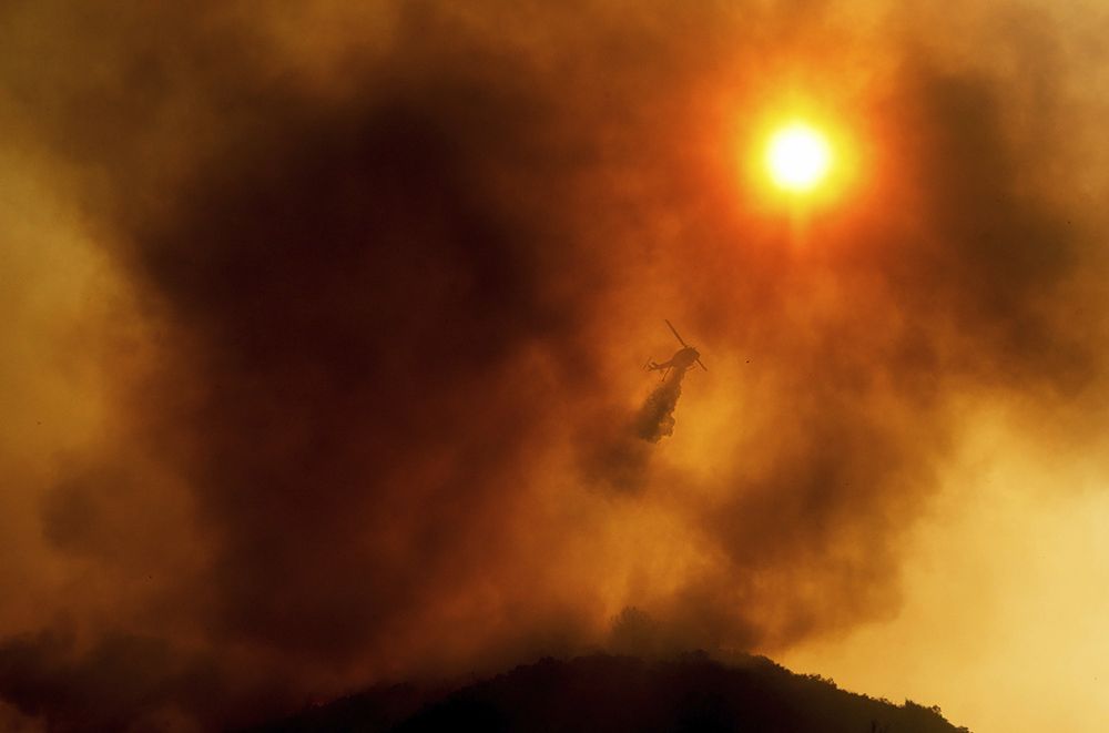

...FIRE WEATHER WATCH IN EFFECT FROM WEDNESDAY MORNING THROUGH SATURDAY EVENING FOR AN UNSEASONABLY HOT AND UNSTABLE AIR MASS CAPABLE OF PRODUCING EXPLOSIVE FIRE BEHAVIOR FROM VERTICAL PLUME GROWTH...LOW RELATIVE HUMIDITY...AND LOCALLY BREEZY WINDS FOR PORTIONS OF THE MOUNTAINS AND FOOTHILLS OF LOS ANGELES AND VENTURA COUNTIES... .The most significant heatwave of the summer season, so far, is on the way middle to latter parts of this week and into next weekend, especially Wednesday through Saturday. Expect temperatures to soar well over 100 degrees over interior areas, locally reaching near 110 degrees over some mountain valley and desert locations. The intense surface heating will bring strong vertical mixing to depths extending over 15-17 thousand feet -- highest Thursday and Friday. Resultant unseasonably strong instability will create a fire environment capable of producing explosive fire behavior through significant vertical plume growth, as minimum relative humidity ranges from 8 to 20 percent in the dry air mass. Overnight relative humidity recovery will be poor to moderate, while the shallow marine layer generally remains displaced closer to the beaches. The Fire Weather Watch area covers portions of the mountains and foothills of Los Angeles and Ventura Counties, which have been a climatologically notorious area for large plume-dominated fires in similar weather patterns to what is coming later this week. While background surface winds are not expected to be strong, or even close to reaching nominal Red Flag Warning criteria, they will be locally breezy in the afternoon and evening over the western Antelope Valley Foothills and vicinity and in other wind-favored areas such as through passes and canyons -- southwest at 10-20 mph gusting to 25-30 mph. These winds will exacerbate the spread of any plume-dominated fires, and add to the potentially dangerous fire-weather environment. Moreover, the western edge of a southwest-states monsoonal moisture influx will overlie Los Angeles and Ventura Counties, which will contribute to the development of atmospheric buoyancy by Friday and Saturday without significantly moistening the air mass -- i.e., displaced away from the core of the moisture source. While lightning-induced fire ignitions are a distinctive possibility on the peripheries of rain cores, the increase in buoyancy will further aid in vertical plume growth accompanied by potential pyrocumulus development and related explosive fire behavior. And with significant fuel loading of exceptionally dry fuels, the fire environment in the mountains and foothills of Los Angeles and Ventura Counties will become especially volatile for Wednesday through Saturday, warranting the issuance of a Fire Weather Watch upon collaboration with local area National Weather Service Core Partners. Analogs to the forthcoming, highly volatile fire-weather environment in Los Angeles County include both the Station Fire, the Bobcat Fire, and the Bridge Fire that burned significant portions of the Angeles National Forest in 2009, 2020, and 2024, respectively. In each case, winds were generally below Red Flag Warning criteria, yet the extreme heat combined with buoyancy greatly offset the sub-marginal wind to create explosive fire behavior and the growth of large fires. Interests in the Fire Weather Watch area should be prepared for similar activity if fires were to start. Also, be aware of passing outflow boundaries that could bring sudden wind-shifts and increased fire-spread rates, even from distant thunderstorms. The National Weather Service in Los Angeles/Oxnard has issued a Fire Weather Watch for an unseasonably hot and unstable air mass capable of producing explosive fire behavior from vertical plume growth, low relative humidity, and locally breezy winds for portions of the mountains and foothills of Los Angeles and Ventura Counties, which is in effect from Wednesday morning through Saturday evening. * TEMPERATURES...Unseasonably hot high temperatures, generally 95-110 degrees and highest Thursday through Saturday, producing unseasonably unstable conditions. * RELATIVE HUMIDITY...Minimum relative humidity 8-20 percent, lowest Wednesday and Thursday. * THUNDERSTORMS...Isolated thunderstorms will be possible Thursday through Saturday, and accompanying lightning strikes will be capable of starting new fires on the peripheries of rain cores. * WINDS...Southwest at 10-20 mph gusting to 20-25 mph over the western Antelope Valley Foothills and vicinity and in other wind-favored areas such as through passes and canyons. Lighter winds elsewhere. Passing outflow boundaries could bring sudden wind-shifts and increased fire-spread rates, even from distant thunderstorms. * IMPACTS...If fire ignition occurs, conditions are favorable for extreme fire behavior and rapid fire growth, which could threaten life and property. Be aware of sudden re-direction of fires in response to passing outflow boundaries. * ADDITIONAL DETAILS...Fire-weather headlines may eventually need to be extended into Sunday and into portions of interior Santa Barbara and San Luis Obispo Counties.
🚨 Fire Weather Watch issued August 17 at 1:19PM PDT until August 23 at 9:00PM PDT by NWS Los Angeles/Oxnard CA 🚨
Additional Details Here.