Hydrology Paper of the Day @jpgannon.bsky.social @hydrochrista.bsky.social @domciruzzi.bsky.social on understanding the teaching of hydrology at the undergraduate level: course titles, assessments, and objectives; textbooks and grading; and the need for shared educational resources and objectives.
11.02.2026 19:25 — 👍 9 🔁 3 💬 0 📌 0
These changes in the timing and magnitude of streamflow, driven by different types of snow drought, require updated strategies to manage water for, amongst others, agriculture, hydropower, and ecological needs.
06.02.2026 17:23 — 👍 1 🔁 0 💬 0 📌 0
Water management implications: Warm snow droughts are expected to become more common, increasing risk for water supplies. Many reservoirs and operating rules weren’t designed for earlier, lower flows, and linking SWE to streamflow is critical for stronger drought earlywarning and forecasting systems
06.02.2026 17:23 — 👍 1 🔁 0 💬 1 📌 0
Snow drought impacts vary by type and region: Warm snow droughts boost cold-season flows but suppress warm-season runoff, while dry and warm-dry types reduce flows year-round, driving larger annual declines. Effects on flow magnitude and timing differ strongly across hydroclimates.
06.02.2026 17:23 — 👍 0 🔁 0 💬 1 📌 0
Snow drought impacts on rivers: Across cool-dry, warm-dry, and warm-wet types, annual streamflow and runoff ratios decline, peak flows shift earlier, and both highs and lows weaken. Back-to-back snow droughts amplify losses as subsurface storage is depleted.
06.02.2026 17:23 — 👍 0 🔁 0 💬 1 📌 0
While all snow droughts generally lower warm-season flow, warm snow droughts uniquely increase cold-season flow, whereas dry/warm-dry types reduce it.
06.02.2026 17:23 — 👍 0 🔁 0 💬 1 📌 0


 15.01.2026 21:51 — 👍 4 🔁 0 💬 0 📌 0

A review and synthesis of post-wildfire shifts in hydrologic processes and streamflow generation mechanisms
A review and synthesis of post-wildfire shifts in hydrologic processes and streamflow generation mechanisms, Ebel, Brian A, Hammond, John C, Walvoord, Michelle A, Partridge, Trevor F, Rey, David M, Murphy, Sheila F
🔥💧 New paper out in Environmental Research: Water led by Brian Ebel!
Synthesis shows how wildfires fundamentally shift hydrologic processes and streamflow generation—from infiltration and runoff to baseflow and flood response — post wildfire.
iopscience.iop.org/article/10.1...
15.01.2026 21:51 — 👍 16 🔁 2 💬 2 📌 1

CSAW REU
Overview
If you know an undergraduate looking for a geosciences REU program, our applications are due in one month! Focus this year on community, air, and water projects!
sites.google.com/view/csaw-re...
12.01.2026 17:58 — 👍 4 🔁 4 💬 0 📌 0
I wrote a commentary discussing Daniele's huge new global synthesis of controls on hydrological processes in forested catchments: read it here: rdcu.be/eXTrq . Some surprising findings on the importance of overland flow, soils and antecedent conditions.
07.01.2026 16:54 — 👍 17 🔁 4 💬 1 📌 0


How do #climate, #antecedent #moisture, #soils, #topography, #geology, and #vegetation control #runoff #processes in #forested #catchments worldwide? Find this out here rdcu.be/eXTtd! @natwater.nature.com
Thanks a lot @mcmillanhydro.bsky.social for this commentary
www.nature.com/articles/s44...!
07.01.2026 09:15 — 👍 13 🔁 2 💬 2 📌 1
Thank you Anne!
01.01.2026 02:48 — 👍 1 🔁 0 💬 0 📌 0


 01.01.2026 00:17 — 👍 3 🔁 0 💬 1 📌 0


 01.01.2026 00:17 — 👍 5 🔁 0 💬 1 📌 0


 01.01.2026 00:17 — 👍 1 🔁 0 💬 1 📌 0
Such a fantastic body of work!
01.01.2026 00:12 — 👍 1 🔁 0 💬 1 📌 0
A piece that felt particularly relevant to write
03.12.2025 12:27 — 👍 7 🔁 2 💬 0 📌 1
Hydrology Paper of the Day @andy-baker.bsky.social on quantifying the drip of water underground as part of rainfall recharge: groundwater monitoring near the water table in Australia; why mines, tunnels and caves are essential monitoring locations; and relating rock aquifer response to rainfall.
27.12.2025 01:56 — 👍 8 🔁 5 💬 0 📌 0


Make sure to check out the supplement for individual signature maps, attribute distributions, and model performance info.
18.12.2025 18:32 — 👍 0 🔁 1 💬 0 📌 0
Process maps derived from signatures highlight strong climate controls in the West, soils/topography in the East, and a scalable path to link process understanding to ungauged basins. Big implications for large-scale hydrologic modeling & change detection.
#Hydrology #Streamflow #Hydroclimate #EGU
18.12.2025 18:32 — 👍 0 🔁 1 💬 1 📌 0
💻🎙️🗞️ Jornalista
🌊🐟 Entusiasta da vida aquática
🌎📍 Brasil 🇧🇷
| #Fire & #Soil Scientist 🔥 | Researcher at IMIB-CSIC (@imibasturias.bsky.social @csic.es)🔬 | Post-fire soil erosion and carbon dynamics 🛠️ | Mountain lover 🏔️ | Boardgamer 🎲 | https://www.agironagarcia.com/ | https://www.fireprosrt.com/ |
Conservation ecologist. Assistant Professor in Ecology at ICBiBE- University of València @uv.es (Spain). Head of the Virtual Beach Ecology Lab 😝 #shorebirds #plovers #seabirds #InvasiveSpecies and any other topic linked to conservation biology.
PhD candidate @ UBuffalo • NSF GRFP
ChemE doing computational systems biology
Multi passionate bean with too many ideas
🫶 Lover of cats, code & crafts
GIS Masters Student at San Diego State University | University of Utah Alum
Chilean-Italian fortunate husband & father; interdisciplinary engineer hydrologist awed by nature & humanity; studying river, soil and catchment processes via innovative monitoring, analysis & modelling; working with natural processes; opinions my own
Non profit dedicated to restoring and conserving land and water across the United States - over 7,000 acres protected to date!
https://uniqueplacestosave.org
Formerly: Cambridge, OMA, BIG; currently: University of Miami; I study climate adaptation and resilience with a focus on flood risk management; failed architect
Membership body for Flood Risk & Water Level Management Authorities across the UK. Member of the European Union of Water Management Associations (EUWMA) www.ada.org.uk
Highway and Flood Risk Management specialist
assistant professor at BOKU University, interested in land policy, planning, flood risk management, wine and politics
Doctoral Candidate at Aalto University researching collaborative water governance. Also working as a consultant specializing in flood risk management.
Independent flood risk consultant helping clients understand and manage risks of flooding. Personal views on flooding, climate change and water issues
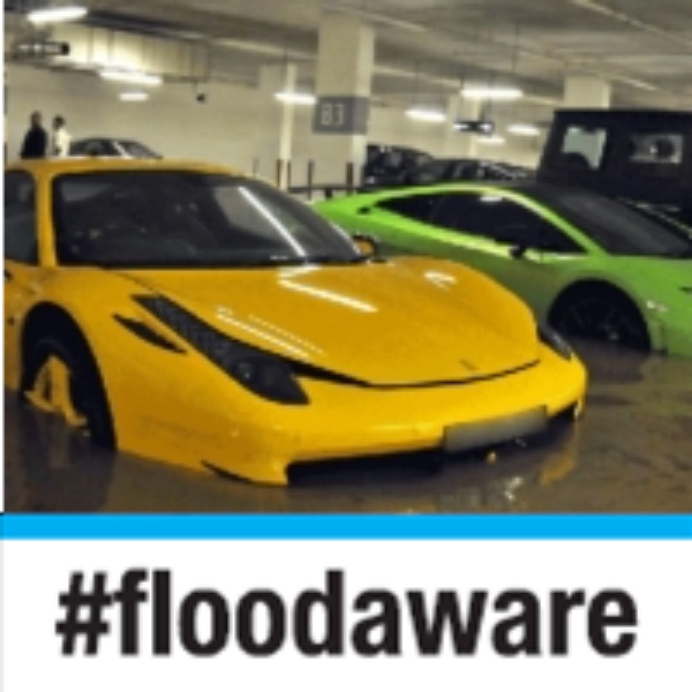
Chartered Flood Risk Manager - Birmingham City Council. MA, FCIWEM, C.WEM, CEnv MIHE. Personal views only #floodaware #thinkdontsink
Ph.D Candidate, Cornell University. Interested in Flood Risk Management, Coastal Development and Urban Planning, and Decision Making under Deep Uncertainty
Yorkshire born and bred but now looking to the Scottish hills and culture. Formerly land surveyor, GIS, digital 3D, Virtual Bradford and flood risk at CBMDC.
Also Munro bagging (203 / 282).
Reader in Geography and Environmental Science at University of Dundee, mum of 2 | Water resource security | Climate change | Water use | Water Quality | Drought & Flood Risk | Emergent Contaminants, views my own
Wargamer, flood risk manager, and zoo keeper.
Lecturer (Assistant Professor) Risk, Environment & Society, King’s College London | former GRI LSE & Flood Resilience Alliance | working on #climate #resilience #adaptation #insurance