We're very pleased to say that our newest BCS member is Dr Geoff Wallace, and that his membership marks our 6,000th sign up at the British Cartographic Society since inception in 1963!
If you'd like to feature in our members spotlight series please contact maplines@cartography.org.uk
17.02.2026 07:30 — 👍 1 🔁 1 💬 0 📌 0
Is there some kind of prize for scoring the epidemiological hat-trick of back-to-back flu, covid, and pneumonia? Asking for a friend with a 2yo in daycare. (And who is on his fourth course of antibiotics in three months.)
16.02.2026 16:02 — 👍 2 🔁 0 💬 0 📌 0
50 in less than 4 months! It’s good to have work but yikes - that kind of pace would leave me in need of therapy.
16.02.2026 06:41 — 👍 1 🔁 0 💬 1 📌 0

Hot take: most maps of the Black Death are outdated and misleading. I made a better one.
#history #GISchat #cartography #map
05.02.2026 11:24 — 👍 10 🔁 1 💬 0 📌 0
I was very happy to receive this e-mail. Thank you for encouraging our profession to take a stand.
29.01.2026 15:31 — 👍 2 🔁 0 💬 1 📌 0

An email with black text and a brown background. The link in the post will take you to a text version for screen readers.
Now landing in AFC member inboxes: The Alliance of Freelance Cartographers is calling upon its members to participate in Friday's general strike.
Full text of the email: mailchi.mp/090a9ac7c273...
29.01.2026 00:52 — 👍 16 🔁 6 💬 2 📌 3
Y'all, having a toddler is no joke. They are just adorable little epidemiological hurricanes. In the last five weeks, I have had pneumonia (twice), strep throat, a skin infection, and viral pinkeye. I spent Christmas bedridden with a 40 degree fever. It's just relentless.
28.12.2025 01:59 — 👍 1 🔁 0 💬 0 📌 0
I feel seen.
21.12.2025 23:59 — 👍 1 🔁 0 💬 0 📌 0
If someone clicked on you in an RTS, what would your voice lines be?
“GYAH FUCK quit sneaking up on me!”
“If you could see the muscle that rolls my eyes it’d be a six pack.”
“Look man, we’re all just doing our best.”
“[cough] sorry [cough] daughter in daycare [pukes]”
“TO THE BARRICADES!”
12.12.2025 12:24 — 👍 1 🔁 1 💬 1 📌 0
It was great fun to make this animation for NiCHE! They were my first environmental history community back in my U of T days and it was a delight and privilege to return their kindness with a nifty map. #envhist #envhum #gischat #cdnhist #histgeog
27.11.2025 21:43 — 👍 8 🔁 3 💬 0 📌 0
I really should have a totally separate billing item for called “Making me map the Balkans before 2008”. Charge will be $8,000 and a trip to my therapist. #gischat
26.11.2025 16:16 — 👍 0 🔁 0 💬 0 📌 0
It's #StarTrek Day. I can't overstate how important this franchise was to me growing up and how relevant it remains to me today. But the fact that the weasels at Paramount are profiting from its utopian vision of the future makes my skin crawl. It's also mostly kept me away from the new shows.
08.09.2025 09:51 — 👍 1 🔁 0 💬 0 📌 0

Visualizing the History of Connections in the Ancient American Art Galleries - The Metropolitan Museum of Art
A new state-of-the-art digital map welcomes and orients visitors upon entering the Ancient American Art galleries.
Hugo Ikehara–Tsukayama, Sofia Ortega-Guerrero, and I wrote an article about our decisions and the production process behind the animated map of the Americas for the Met Museum's Michael C. Rockefeller Wing!
#gischat #history #arthistory #gis #cartography #maps
05.06.2025 10:32 — 👍 5 🔁 0 💬 0 📌 0
The second half of the Oceania video is a visualization of the Pacific worldview called "Spheric Oceania" by artist Sean Connelly.
03.06.2025 20:36 — 👍 0 🔁 0 💬 0 📌 0
God this is my whole life
06.02.2025 20:46 — 👍 0 🔁 0 💬 0 📌 0
Das Map
06.02.2025 20:44 — 👍 0 🔁 0 💬 0 📌 0
I did this for the Yucatán peninsula from 1550 to 1690 in my PhD and even in the tiny number of documents that still exist the depredation of empire was just astonishing. It enrages me when I think of that playing out across a whole empire for centuries. It’s time we started collecting the receipts.
06.02.2025 20:38 — 👍 0 🔁 0 💬 0 📌 0
A complete dataset of all archival records detailing colonial Spanish taxation/appropriation/forced sale of goods/currency/labour from indigenous communities across the empire from 1500 to 1820. A full accounting of the wealth and work stolen by the colonial project with coordinates. #gischat
06.02.2025 20:32 — 👍 1 🔁 0 💬 1 📌 0

A map entitled "The Province of Yucatán in the Early Colonial Period" showing the Yucatán Peninsula, Mexico in the seventeenth century. The extent of Spanish control is demarcated as covering the northeastern third of the Peninsula, with both the interior and eastern coast labeled as beyond Spanish colonial influence. The provincial capital of Mérida and the Spanish towns of Campeche in the southwest and Valladolid in the east are labeled, as are prominent Maya towns called "cabeceras," through which the Spanish extended their influence into indigenous society and territory. Major roads criss-cross the region under Spanish control linking major towns and cabeceras together and connecting them to port cities dotted along the coast. The following approximate political regions are prominently: Sahcabchén (extreme southwest), Champotón (far southwest, north of Sahcabchén), Camino Real Alto and Camino Real Bajo (north of Champotón and following the highway from Campeche to Mérida along the western coast), Sierra (along a ridge that extends from northwest to southeast across much of the Peninsula), Costa (the northern central coastal region), Beneficios Bajos (between Sierra and Costa, essentially in the central region of the area under Spanish control), Dzonot (a small district east of Costa and largely uninhabited), Tizimín (in the northeast, east of Costa and Dzonot), Chancenote (the extreme northeastern part of peninsula under Spanish control), Chancenote (south of Tizímin and north of Valladolid), Valladolid (in the central eastern region, named after the eponymous Spanish town), Beneficios altos (south of Valladolid and southeast of Beneficios Bajos), and Bacalar (in the extreme southeast, and abandoned in around 1650). A large uncolonized region called the "Montaña" or Borderlands is also labeled, beginning south of Sierra and extending southwards off the map.
Early colonial Yucatán. This map appears in "The Friar and the Maya: Diego de Landa and the Account of the Things of Yucatan" by @restall.bsky.social, Amara Solari, John F. Chuchiak, and Traci Ardren (2023, Univ. Press of Colorado).
#mapmonday #GISchat #history
16.12.2024 22:46 — 👍 8 🔁 2 💬 1 📌 0

Bering Bog Bridge? New research rewrites key crossing’s landscape
New research finds Bering Land Bridge was boggy with meandering rivers, not an arid steppe as previously thought
AGU put out a press release about our #AGU2024 presentations on the Bering Land Bridge (which, ICYMI is it a massive amount of exposed land during sea level lowstands!)
Check out the teaser below and come see our posters if you are in town! PP23C-0564 to 0569 (Tuesday afternoon)
09.12.2024 14:53 — 👍 24 🔁 4 💬 0 📌 3

The Pacific. This map appears as a double-page frontispiece in "Migrant Ecologies: Environmental Histories of the Pacific World" (ed. Beattie, Jones, & Melillo, University of Hawai'i Press, 2022).
#mapmonday #cartography #envhist #GISchat
02.12.2024 16:47 — 👍 18 🔁 3 💬 0 📌 0
I've struggled to map exactly this multiple times - this projection is a beautiful and elegant solution. Well done!
26.11.2024 19:02 — 👍 1 🔁 0 💬 0 📌 0
Why didn’t anyone warn me that my dad was here too
21.11.2024 19:42 — 👍 1 🔁 0 💬 0 📌 0
Ooooh me! This looks great!
20.11.2024 10:10 — 👍 1 🔁 0 💬 0 📌 0
Not sure why it's showing up in lower res, but it looks good on my desktop - try that. If it doesn't work I'll root around for a less compressed version.
19.11.2024 11:32 — 👍 0 🔁 0 💬 0 📌 0
Yes! For maps from scratch: No labels smaller than 6pt, no lines thinner than .3pt, and at least 25% K values between shades of gray (so you really only have 3 shades to work between black and white). For conversion from color to grayscale: Start over 🤦🏻♂️
18.11.2024 19:06 — 👍 1 🔁 0 💬 1 📌 0

I'm currently working on an atlas of environmental history with a few historian colleagues of mine. It won't be ready for a few years, but here's a sneak peek.
#envhist #history #maps #gischat #cartography
18.11.2024 12:54 — 👍 14 🔁 1 💬 2 📌 0
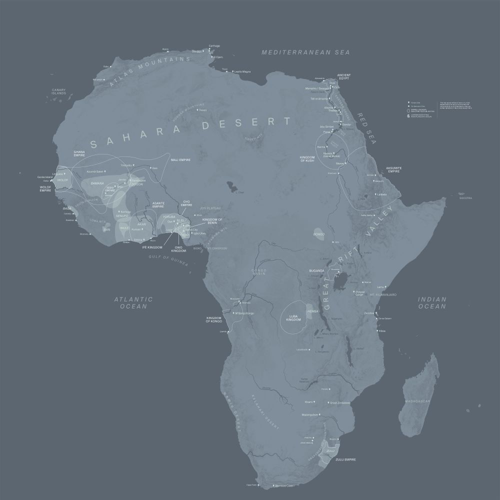
I do maps for museums too! This map of early civilizations in Africa was on the wall at the @metmuseum.bsky.social last year, and I've got another 30-or-so maps going up at the Met when they finish the Rockefeller Wing renovations later this year!
#maps #cartography #history #gischat
18.11.2024 12:52 — 👍 20 🔁 4 💬 1 📌 0

[obligatory WWII map post by historical cartographer]
#gischat #cartography #history #geosky #maps
18.11.2024 12:50 — 👍 16 🔁 1 💬 0 📌 0
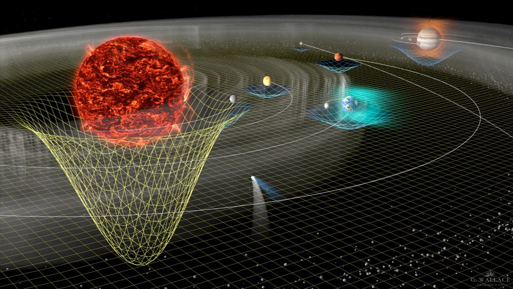
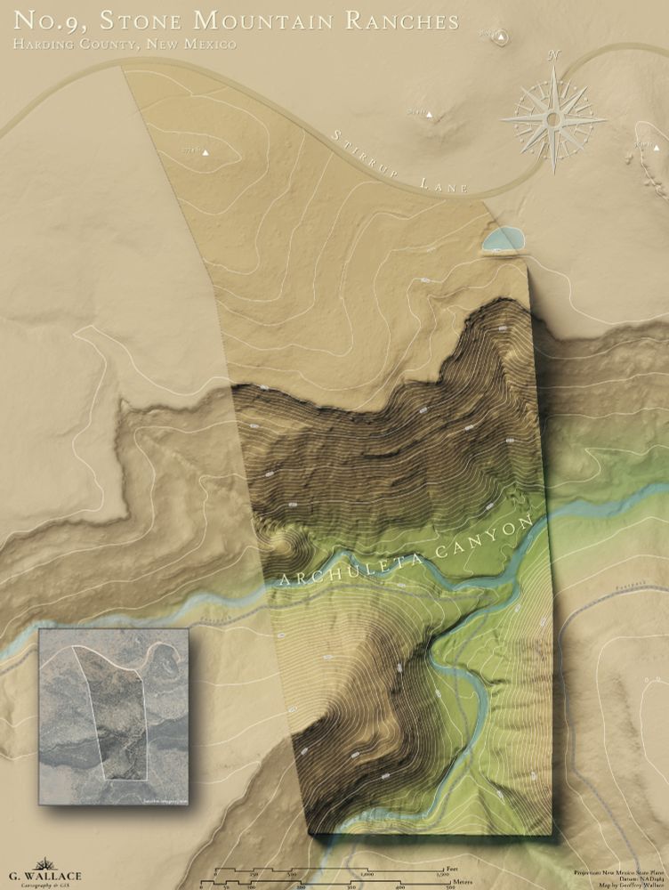
I also occasionally faff about in Blender, where I made this map of the solar system for @dagomardegroot.bsky.social and this wall map of a land parcel in New Mexico for a friend.
#gischat #cartography #maps #geosky
18.11.2024 12:48 — 👍 13 🔁 5 💬 1 📌 0
Travel in time, witness the people & places that changed our lives in Britain & beyond using our maps as a window into history, brought alive by our researchers & authors.
Great Gifts!
From £3.50 pp. https://www.alangodfreymaps.co.uk/acatalog/home.html
Mapping+Excellence+Community
The BCS promotes the art & science of mapmaking and all aspects of cartography to a wide audience.
Winter Lecture 11th Dec
GeoFutures questionnaire during December
GeoFutures 25th March 2026
Germinate: Environmental History Review (GEHR) is an open-access, digital publication of the American Society for Environmental History (ASEH). www.g-ehr.com
Researcher, writer, & teacher of stuff Canadian, historical, & environmental.
https://www.mqup.ca/content/search?type%5B%5D=books&SearchText=Maceachern+
"Thou shalt not make a machine in the likeness of a human mind."
🦢=🦖 She/her
Science communicator talking about genetics, biology, chemistry, and blimps. She/her
#CriticalRole #TheLegendOfVoxMachina #MightyNein https://streamily.com/samriegel
Waitress turned Congresswoman for the Bronx and Queens. Grassroots elected, small-dollar supported. A better world is possible.
ocasiocortez.com
Actor. Writer. Producer. Internet Native. “Lost Daughter of Sparta” out March 17, preorder now! https://bit.ly/LostDaughterOfSparta
Rika of the Elite 4. Dragon Age: The Veilguard’s Rook. The Ghost of Yōtei | Worlds Beyond Number| D20, Dropout, Critical Role | Gender🌊: all pronouns
Senior Producer at Critical Role | LIVE shows | All posts are solely my own opinion
Game Designer for Critical Role 🎲
Daggerheart 🗡️💙
Candela Obscura 🕯️
@WillingAndFable ⚔️
Game Designer/Podcaster/Writer/Producer/TTRPG Streamer
🏳️🌈 (she/her)
SAG-AFTRA is the world’s largest labor union representing performers and broadcasters. Reposts or follows do not equal endorsements. #SagAftraMember
Dad. Husband. Vet. Ex NSC/White House Staff. Running for U.S. Senate
a comedy streamer with all of your favorite shows
🧔♂️ Game Changer
📢 Make Some Noise
🎲 Dimension 20
🫂 Very Important People
🐷 Smartypants
dropout.tv
comedian. angel.
Host of "Dirty Laundry" on dropout.tv
☀️ GLADLANDS
☁️ CLOUDWARD, HO!
⚡️TITAN TAKEDOWN
💅DUNGEONS & DRAG QUEENS S2
✨MISFITS & MAGIC
💥NEVER STOP BLOWING UP
🧙🏿♂️ FANTASY HIGH
🧠MENTOPOLIS
📖 NEVERAFTER
🚀 STARSTRUCK ODYSSEY
dropout.tv/shows/dimension-20