Heavy snow is expected for an hour or two before tapering to scattered flurries.
09.12.2025 16:04 — 👍 0 🔁 0 💬 0 📌 0

11:04 AM ET - Special Weather Statement in effect for Chatham-Kent, Elgin, London-Middlesex, Sarnia-Lambton and Windsor-Essex.
Snowfall rates of 2 to 4 cm per hour and reduced visibility in heavy snow is expected this morning.
09.12.2025 16:04 — 👍 0 🔁 0 💬 1 📌 0

10:24 AM ET - Snow continues to push through Southwestern Ontario. Some heavier snow (shown in the yellow) is moving through the #Chatham area.
Watch for snow covered and slippery road conditions. Travel with caution.
#ONwx
09.12.2025 15:24 — 👍 0 🔁 0 💬 0 📌 0
Temperatures in blue represent forecasted wind chill values.
More details: https://buff.ly/E4sMI7u
09.12.2025 01:58 — 👍 0 🔁 0 💬 0 📌 0
A Snow Squall Watch (Yellow Level) is in effect for the Bruce Peninsula, with some snow squalls expected tomorrow. Snowfall amounts up to 15 centimetres will be possible.
For Wednesday, some rain and snow is expected across much of the area. Uncertainty remains in amounts and timing.
09.12.2025 01:58 — 👍 0 🔁 0 💬 1 📌 0

Some brief snow will push across the region tomorrow, with less than 5 centimetres expected across the area.
The morning commute may be affected tomorrow due to the snow. Road conditions will likely become snow covered and slippery due to the cold temperatures.
09.12.2025 01:58 — 👍 0 🔁 0 💬 1 📌 0
Significantly reduced visibility in heavy snow and local blowing snow is expected.
#ONwx
09.12.2025 01:46 — 👍 0 🔁 0 💬 0 📌 0
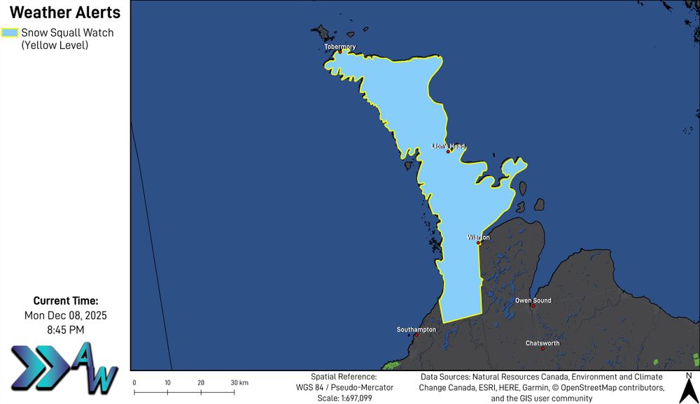
8:46 PM ET - Snow Squall Watch (Yellow Level) in effect for Bruce Peninsula - Sauble Beach - Tobermory.
Snow squalls are likely to begin Tuesday morning and continuing into Tuesday evening.
Total snowfall amounts of 10 to 20 cm is expected, with locally higher amounts possible.
09.12.2025 01:46 — 👍 0 🔁 0 💬 1 📌 0
Details remain uncertain at this time.
Temperatures in blue represent forecasted wind chill values.
More details: https://buff.ly/aMuboia
05.12.2025 03:07 — 👍 0 🔁 0 💬 0 📌 0
Some quick moving snow appears likely for Saturday, and another round for Sunday. Accumulations will likely remain low, but slippery travel is possible.
Next week is expected to feature multiple clippers, likely bringing continuous chances at accumulating snow.
05.12.2025 03:07 — 👍 0 🔁 0 💬 1 📌 0

Friday will bring another chilly day to the region, with most areas seeing a mix of sun and cloud. A few flurries will be around in Central Ontario, with some light snow in the Bruce Peninsula.
Some snow remains in the forecast for the foreseeable future.
05.12.2025 03:07 — 👍 0 🔁 0 💬 1 📌 0
More details: https://buff.ly/qj8aAmJ
03.12.2025 04:42 — 👍 0 🔁 0 💬 0 📌 0
This will likely bring a quick burst of snow, along with strong wind gusts. Temperatures will drop behind the front.
Looking ahead to the rest of the week,Friday morning will likely bring wind chills near -20ºC for many areas.
Temperatures in blue represent forecasted wind chill values.
03.12.2025 04:42 — 👍 0 🔁 0 💬 1 📌 0

Wednesday will bring a mix of sun and cloud across the area, with the Bruce Peninsula and portions of Central Ontario seeing flurries and snow squalls.
Some snow will be possible across the area tomorrow evening as an arctic front passes through the region.
03.12.2025 04:42 — 👍 1 🔁 0 💬 1 📌 0
More details: https://buff.ly/Pl2GUX9
01.12.2025 01:56 — 👍 0 🔁 0 💬 0 📌 0
Snow Squall Watches (Yellow level) are in effect as well.
Some snow will be possible late tomorrow into early Tuesday morning, mainly for areas along Lake Erie.
Temperatures in blue represent forecasted wind chill values.
Welcome to December and Meteorological Winter!
01.12.2025 01:55 — 👍 0 🔁 0 💬 1 📌 0
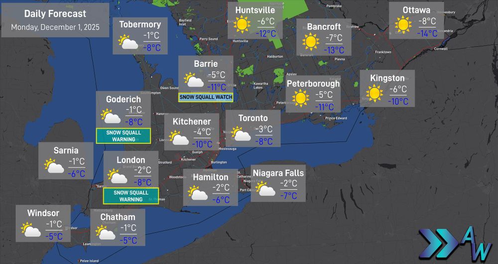
A chilly day is expected across the region tomorrow, with high temperatures below the freezing mark.
Snow Squall Warnings (Yellow level) are in effect tonight. Travel with caution in affected areas. Snowfall of 10 to 20 centimetres is expected.
01.12.2025 01:55 — 👍 1 🔁 0 💬 1 📌 0
Special Weather Statement in effect for Chatham-Kent, Elgin County and Windsor-Essex for 10 centimetres to possibly 15 centimetres.
Travel conditions will deteriorate tonight. Environment Canada states lake effect flurries are likely Sunday with the potential for snow squalls.
29.11.2025 21:35 — 👍 0 🔁 0 💬 0 📌 0

4:35 PM ET - Snowfall Warnings (Yellow Level) have been issued for much of Southern Ontario. Environment Canada states 10 to 20 centimetres is likely for many areas.
29.11.2025 21:35 — 👍 0 🔁 0 💬 1 📌 0
Some strong wind gusts and lake effect snow are expected Sunday.
29.11.2025 03:27 — 👍 0 🔁 0 💬 0 📌 0
Areas along Lake Ontario will see Trace to 5 centimetres of snow. Much of the Highway 401 corridor will see 5 to 10 centimetres, while Midwestern and Central Ontario see 10 to 15 centimetres.
Snow will begin wrapping up Sunday morning.
29.11.2025 03:27 — 👍 0 🔁 0 💬 1 📌 0

#ONwx Accumulating snow is expected across Southern Ontario tomorrow into Sunday.
Snow will likely begin breaking out over Southwestern Ontario during the afternoon to evening hours.
Road conditions will likely become snow covered and slippery quickly.
29.11.2025 03:27 — 👍 1 🔁 0 💬 1 📌 0

6:37 AM ET - Multiple weather alerts remain in effect this morning (Image 1) including Snow Squall Warnings (Orange and Yellow levels).
Many roads in Midwestern Ontario are snow packed this morning. Snow squalls will continue through the day today before weakening.
#ONwx
28.11.2025 11:37 — 👍 0 🔁 0 💬 0 📌 0
Current data suggests poor visibility and heavy snowfall will be possible with this system, and the snow will continue into Sunday. Stay tuned for further updates.
28.11.2025 03:06 — 👍 0 🔁 0 💬 0 📌 0
Some rain may mix in and reduce snowfall totals, however some uncertainty remains where and if this will occur.
Some of the latest high resolution data coming in shows snow moving into Southwestern Ontario during the evening hours on Saturday. The timing also remains uncertain at this time.
28.11.2025 03:06 — 👍 0 🔁 0 💬 1 📌 0
Some uncertainty still remains at this time, but it appears that this system will bring another chance for snow to the area. This time, it appears that the snowfall would be more widespread.
28.11.2025 03:06 — 👍 0 🔁 0 💬 1 📌 0

❄️ LOOK AHEAD: More Snow Likely This Weekend
Once the snow squalls wrap up late Friday into early Saturday morning, focus will shift to another system that is expected to impact the region Saturday afternoon into Sunday.
28.11.2025 03:06 — 👍 0 🔁 0 💬 1 📌 0

9:55 PM ET - Here is a road conditions update for Midwestern #Ontario.
Data from 511 Ontario/MTO reports many highways are snow covered, many with fair to poor visibility.
Travel conditions will deteriorate tonight.
#ONwx
28.11.2025 02:55 — 👍 0 🔁 0 💬 0 📌 0
Snow squalls are expected to weaken late tomorrow into Saturday morning.
We are now beginning to track a system that may bring snow to the area Saturday into Sunday. Stay tuned for more updates.
More details: https://buff.ly/9ZiRmNv
28.11.2025 01:35 — 👍 0 🔁 0 💬 0 📌 0
Avoid travel if possible. Snow Squall Watches (Yellow level) remain in effect, as well as Special Weather Statements.
The snow squalls will shift throughout the day tomorrow. Poor road conditions and poor visibility are expected again tomorrow.
28.11.2025 01:35 — 👍 0 🔁 0 💬 1 📌 0
Canadian tornado guru at uwo.ca/ntp and the new CSSL.ca at WesternU
in Londontario, my debut album is 'Fifty' (bit.ly/40WqxUy) and my latest album is 'Cover Me' (bit.ly/3V1MnCG), Great Lakes sailor, ECCC & YorkU alumnus, #WorkForPeace
Atmospheric-Physicist/Professional Meteorologist in applied meteorology & forecasting in the public, private and non-profit sectors. Past President of the Canadian Meteorological and Oceanographic Society. Professional member of the AMS and RMetS (UK), AGU
Founded in 2017 at Western University with support from ImpactWX.com, NTP aims to detect and document all tornadoes in Canada and uncover Canada’s true tornado climatology. Now part of the Canadian Severe Storms Lab! See uwo.ca/ntp & cssl.ca.
Send your reports to the Northern Tornadoes Project. Managed by Lesley Elliott (MSc, Research Meteorologist) and the NTP team at Western University.
NTP Main Account: @westernuntp.bsky.social
NTP Website: https://www.uwo.ca/ntp/
Digital reporter at @weathernetwork.bsky.social. Former Metroland Media reporter, The Sheridan Sun editor. Sheridan College print-journalism graduate. X: https://twitter.com/HowesNathan | Bio: https://www.theweathernetwork.com/en/news/author/nathan-howes
Storm Spotter/Chef/Photographer
Weather/Aurora/Aviation/Landscape
📍Southwestern Ontario
News Anchor & Reporter w/ @citynewskit.bsky.social | Broadcast Host w/ London Majors | Fanshawe College Alumni
Lover of baseball, fantasy sports, sneakers, and keeping in touch with the #LdnOnt, #Kitchener, and #Waterloo communities!
Morning News Anchor on 570 NewsRadio/CityNews Kitchener.
Proud Hockey Mamma 🏒/ Runner 🏃♀️ / Always down to talk D&D 🎲
Unofficial bot sharing alerts from NWS Detroit/Pontiac MI.
This account is not monitored. Contact @wandrme.paxex.aero if needed.
Official Bluesky account for NOAA's National Weather Service.
NMP was founded by Western University & ImpactWX and aims to connect and enhance Canada's weather networks. Creator of the Canadian Mesonet Portal. @meso.cssl.ca
Where weather comes to life - your ultimate source for breaking stories, expert insights, and natural wonders.
⛈️ Senior meteorologist @accuweather 🎓 @millersvilleu grad 🥨 Philly area native now back home ⚾️ @phillies fan (opinions my own)
Stormchaser, meteorologist, volcano explorer. I have an interesting life. You’ll see me on the Weather Network doing things that I really don’t recommend anyone else doing … 🌋🌪️🦈⛈️ Also Warhammer. From time to time.