There were several reports of possible tornadoes and photos/video of funnel clouds yesterday in the Winnipeg, MB area.
The Winnipeg NTP survey team will investigate these potential tornadoes today.
Please send damage reports to ntp@uwo.ca or submit via uwo.ca/ntp. Thanks!
#MBstorm
07.08.2025 13:19 — 👍 6 🔁 3 💬 0 📌 0
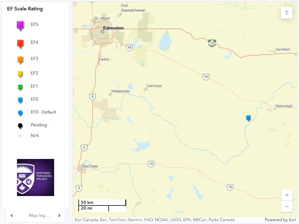
The NTP has confirmed a tornado that occurred near Hardisty, AB on Aug 3. The tornado caused minor tree damage and was assigned an EF0 rating.
For details, go to the NTP blog: uwo.ca/.../tornado_...
#ABstorm
Thanks to @instantweather.bsky.social for the numerous reports for this event!
05.08.2025 03:06 — 👍 8 🔁 4 💬 0 📌 0
Will be there! And looking forward to seeing @adamskinner.bsky.social and his band 'Face the Lion' open. #Barrie #KempenFest
02.08.2025 13:44 — 👍 3 🔁 1 💬 0 📌 0
When he was just turfed by his constituents in the last election? That’s not part of the ‘tradition’, CBC.
02.08.2025 12:10 — 👍 3 🔁 0 💬 0 📌 0
Canadians 🇨🇦
Be in the know
Any reason to back away.
The world’s worst business man was never going to make a deal.
Dictator don is only looking for knee bending corruption payouts not a real trade deal.
31.07.2025 11:39 — 👍 3 🔁 2 💬 0 📌 0
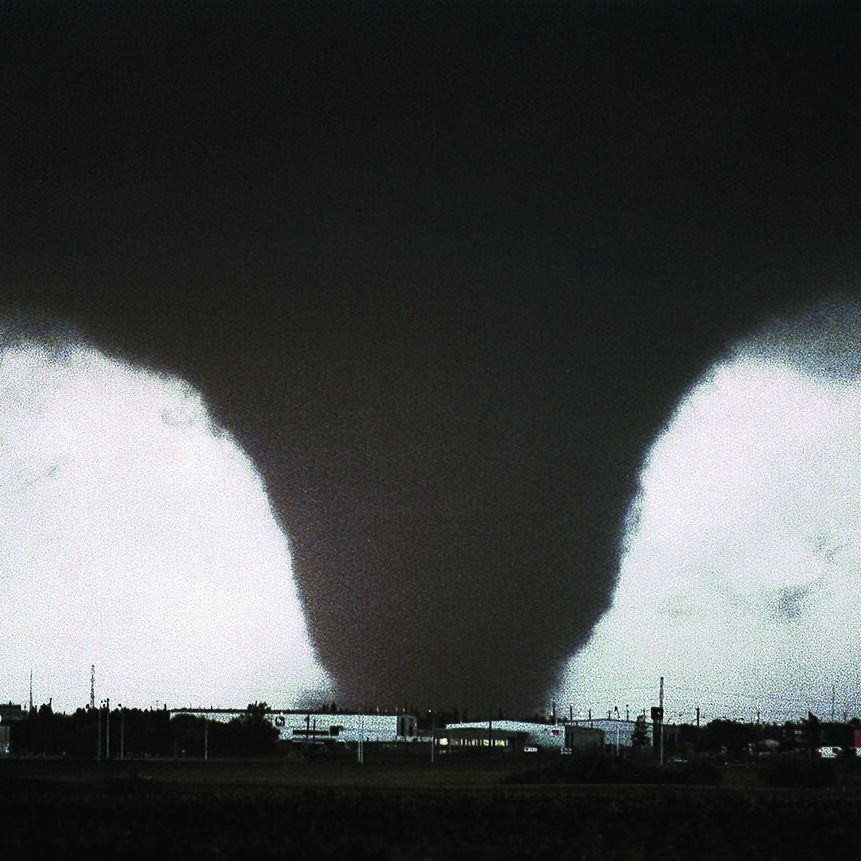
The provided photo shows the iconic image of the 1987 Edmonton tornado, captured by photographer Steve Simon. It depicts a large, wedge-shaped funnel cloud descending from a dark storm sky, touching down over an industrial area known as Refinery Row in eastern Edmonton, Alberta. The tornado appears as a bright, contrasting formation against the blackened background, with buildings, utility poles, and structures visible in the foreground.
On July 31, 1987, an F4 (possibly an F5) tornado hit the eastern parts of Edmonton and Strathcona County.
It left 27 dead, injured 300 and caused $332 million in damages.
This is the story of Black Friday.
📸 Steve Simon
🧵 1/12
31.07.2025 12:01 — 👍 84 🔁 34 💬 5 📌 12
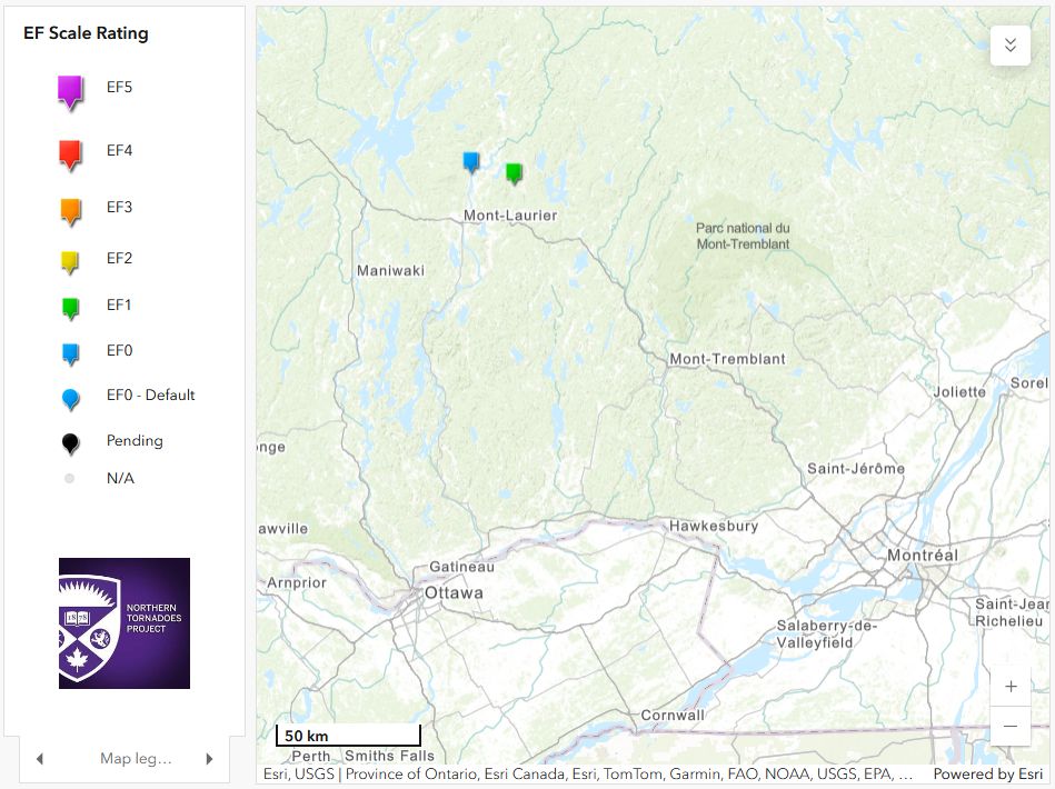
Following an NTP ground/survey, the NTP has confirmed that two downbursts occurred near Mont-Laurier, QC on July 24.
The downburst at Chute-Saint-Philippe was rated EF1 while the other at Ferme-Neuve was rated EF0.
Details are provided at the NTP blog here:
uwo.ca/ntp/blog/202...
#meteoQC
29.07.2025 14:52 — 👍 8 🔁 2 💬 0 📌 1
The World Court throws f-bombs — and lots of 'em
With its landmark ruling, the International Court of Justice has finally offered its first opinion on questions about climate change, concluding that rich, high-polluting countries have a particular o...
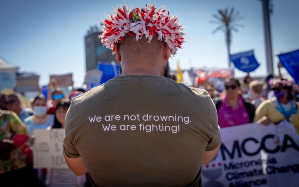
Canada has been desperate for the global 'rules-based order' to remain in place, yet increasingly that order is at odds with Canada's actions (or lack of them) on climate change. This landmark ruling by the #ICJ paints Canada - and PM Carney - into a corner. www.nationalobserver.com/2025/07/28/o...
29.07.2025 11:15 — 👍 3 🔁 0 💬 0 📌 0
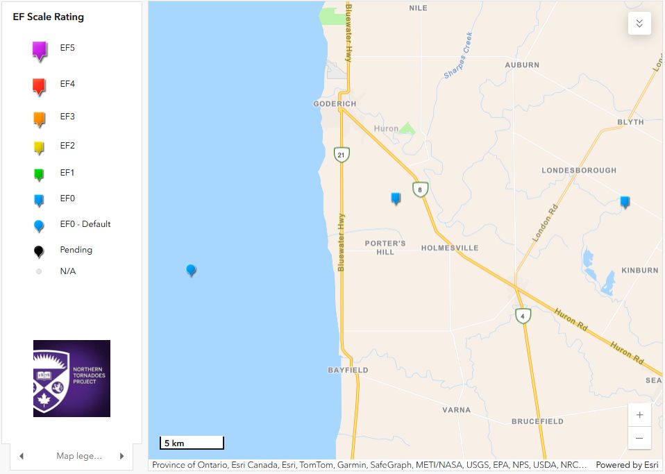
The NTP has confirmed three tornadoes that occurred in the Goderich, ON area on July 26. The first occurred over Lake Huron and was rated EF0-Default. The other two occurred over land and were assigned an EF0 rating after a damage survey was conducted. Full details: uwo.ca/ntp/blog/202... #ONstorm
28.07.2025 20:57 — 👍 15 🔁 7 💬 2 📌 0
Storm has weakened but still racing east, now into QC. Hard to tell how much damage the MCS caused given low population density of the affected areas. Hydro One outage map suggests some damage but perhaps winds were not as intense as expected. Will see if more reports emerge. #ONstorm #meteoQC
28.07.2025 12:35 — 👍 3 🔁 1 💬 0 📌 0
An intense thunderstorm system is moving rapidly E across Northern Ontario. An ECCC severe thunderstorm warning cites winds to 130 km/h. Damage has already been reported. If this system produces widespread damage over a distance of hundreds of km, it could be classified as a #derecho #ONstorm
28.07.2025 02:17 — 👍 9 🔁 2 💬 1 📌 1
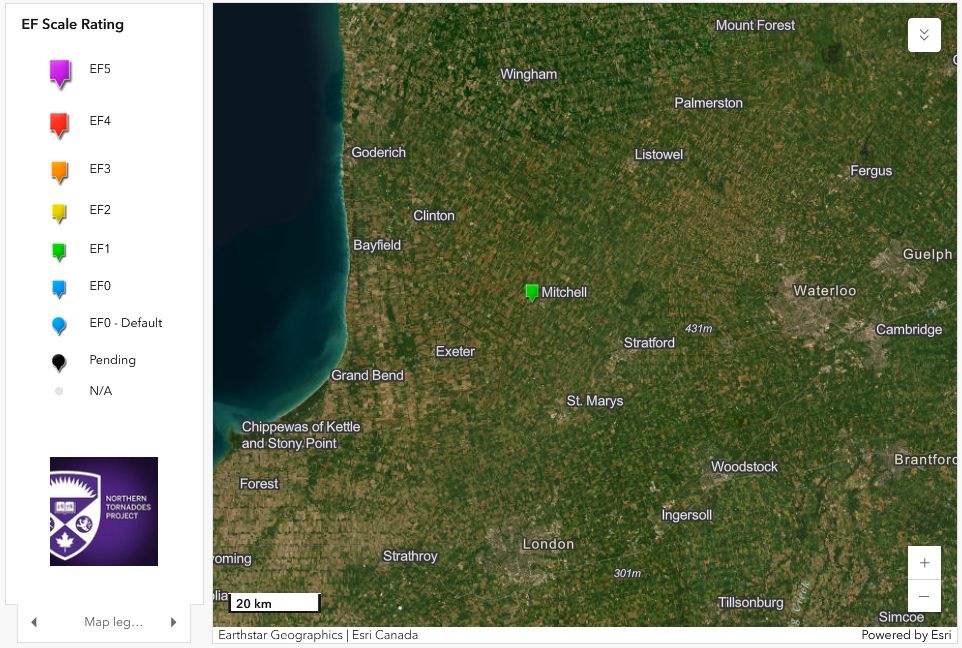
The NTP has confirmed - following a ground/drone investigation - that a downburst caused damage rated up to EF1 at Mitchell, ON on July 24. The worst damage was to a drive shed with maximum winds estimated at 150 km/h.
Full details: uwo.ca/ntp/blog/202...
#ONstorm
27.07.2025 19:34 — 👍 15 🔁 5 💬 1 📌 0
FYI - the threat has passed
27.07.2025 02:45 — 👍 3 🔁 1 💬 0 📌 0
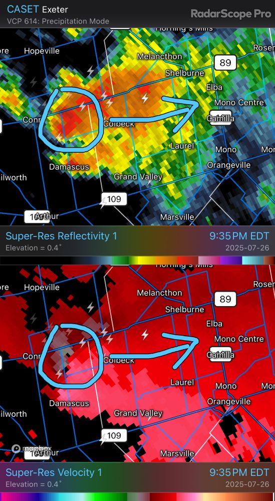
That cell now has low-level rotation, and heading ENE towards Mono Centre. If in the area, take shelter and monitor any EC warnings. #ONstorm
27.07.2025 01:42 — 👍 1 🔁 1 💬 0 📌 1
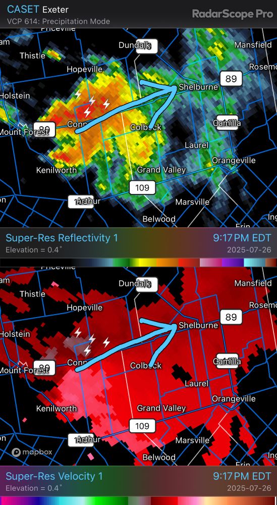
I’m still concerned that this cluster of storms heading towards Shelburne could develop rotation and possibly produce a tornado. Keep and eye out if in the area! #ONstorm
27.07.2025 01:25 — 👍 2 🔁 0 💬 0 📌 0
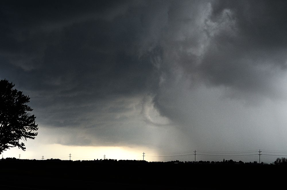
Supercell tornado appears to have come ashore off southern Lake Huron - funnel cloud with ground circulation near Blacks Point / Potters Hill in the Bayfield area. Take shelter Clinton/Blyth area. #ONstorm
www.facebook.com/share/v/19BA...
26.07.2025 23:23 — 👍 10 🔁 3 💬 0 📌 0
Nice back-sheared anvil on that storm well south of Sandusky, OH near Bloomville, as seen from River Canard, ON #OHwx
26.07.2025 21:47 — 👍 2 🔁 1 💬 0 📌 0
This was interesting as well...the underside of the updraft of the Mitchell storm had a number of these areas of rotation (anti-cyclonic here). But no prominent cyclonic rotation. Normal speed, BTW. #ONstorm
25.07.2025 03:30 — 👍 12 🔁 3 💬 2 📌 0
So it's not enough to avoid crossing the border - now we need to avoid getting near it?
If the details here are true, this is an international incident that needs to be promptly addressed.
25.07.2025 03:11 — 👍 9 🔁 2 💬 1 📌 0
Saw a few interesting things chasing the storms tonight in SW ON. But this is one I can't explain - never seen anything like it before. Photo has been processed to better show the feature of interest here. Happened so fast I couldn't tell if it was actually rotating. Was on leading edge. #ONstorm
25.07.2025 03:06 — 👍 44 🔁 4 💬 2 📌 1
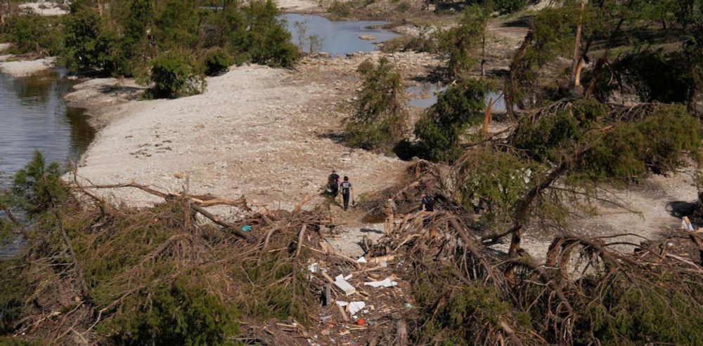
Widespread tree damage Dublin to Mitchell and further SE. A lot of trees with rot but some healthy too. Lots of large deciduous branches down and conifers snapped. Power out in those two towns. Mitchell hardest hit it seems. Corn damage tool, from both wind and in some places from hail. #ONstorm
25.07.2025 00:35 — 👍 9 🔁 4 💬 2 📌 0
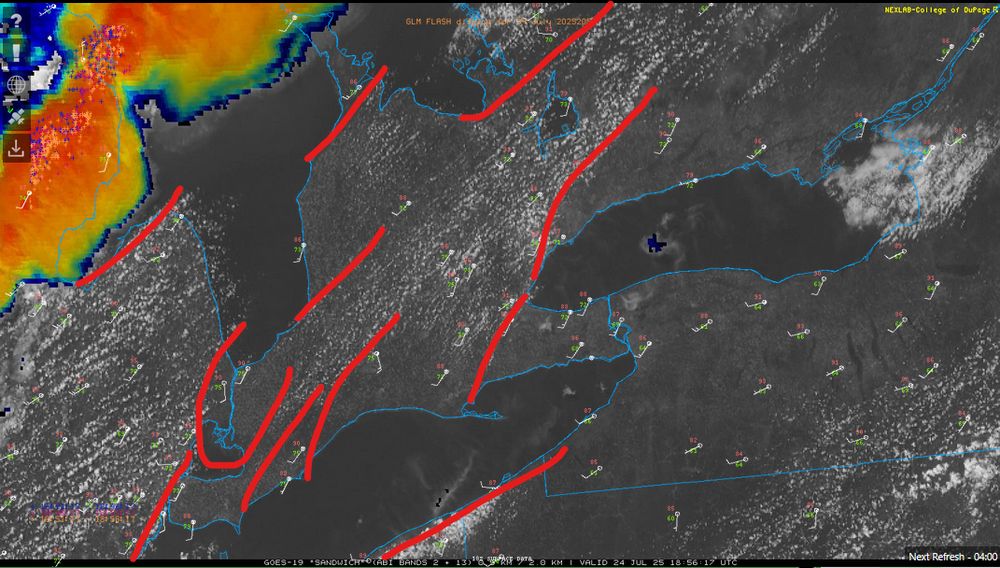
Typical lake-breeze front setup for a moderate to strong SW flow. Will be interesting to see how these convergence zones influence storms coming across from Michigan. Am not expecting convection initiation until those MI storms (and better mid-level moisture) begin to approach. #ONstorm
24.07.2025 19:09 — 👍 4 🔁 1 💬 0 📌 0
There’s #3 - hopefully that’s it for a while. GenX can’t take any more… RIP
24.07.2025 17:36 — 👍 2 🔁 0 💬 0 📌 0
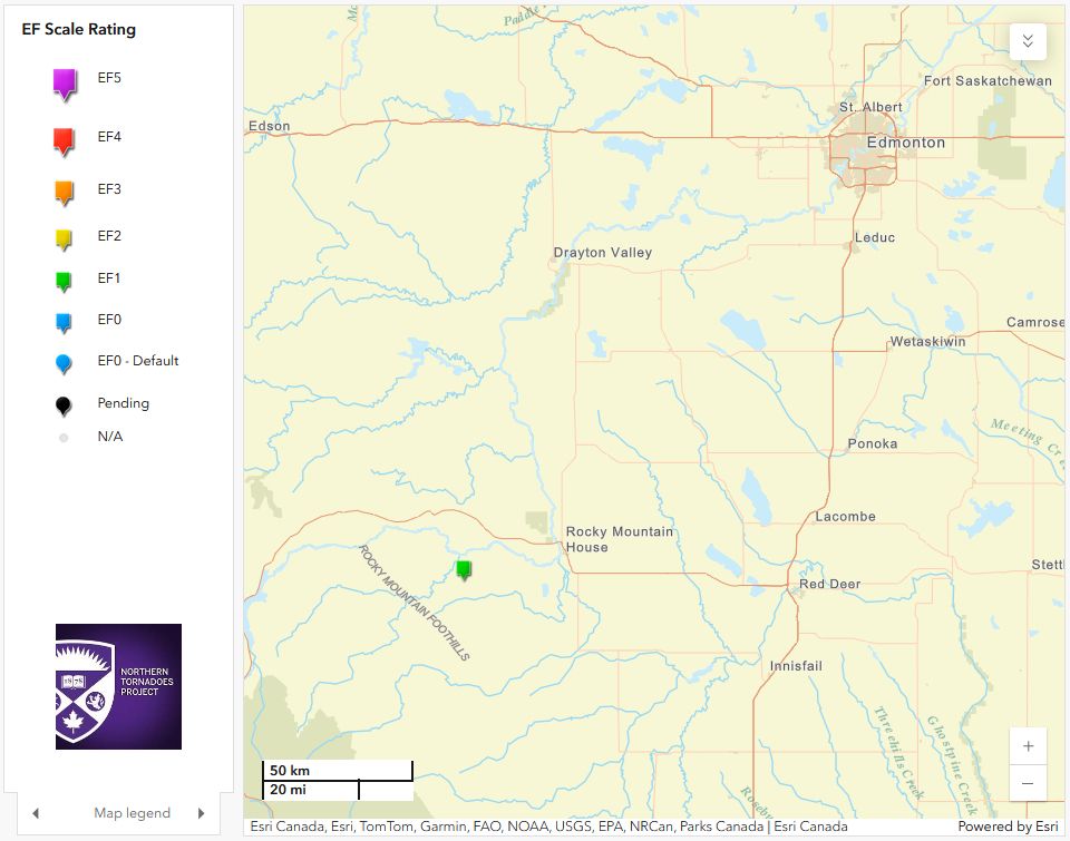
The NTP has confirmed an EF1 tornado that occurred west of Red Deer, AB on the afternoon of July 9. Thanks to Ben Chernesky for providing drone imagery of the narrow path of tree damage.
More details at uwo.ca/ntp/blog/202...
#ABstorm
23.07.2025 22:15 — 👍 8 🔁 3 💬 0 📌 0
YouTube video by OzzyOsbourneVEVO
Ozzy Osbourne - You Can't Kill Rock and Roll (Official Audio)
Ozzy may no longer be with us, but you can't kill rock and roll. It's here to stay... RIP
youtu.be/1tGt3yefz4M?...
22.07.2025 18:35 — 👍 4 🔁 0 💬 1 📌 0
Boo! But what comes out of GenAI may be better than a quarter of the reviews I’ve seen in the past several years. Discouraging is a good word for it.
17.07.2025 22:37 — 👍 1 🔁 0 💬 0 📌 0
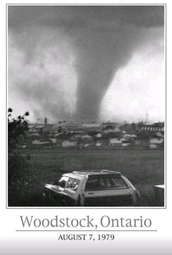
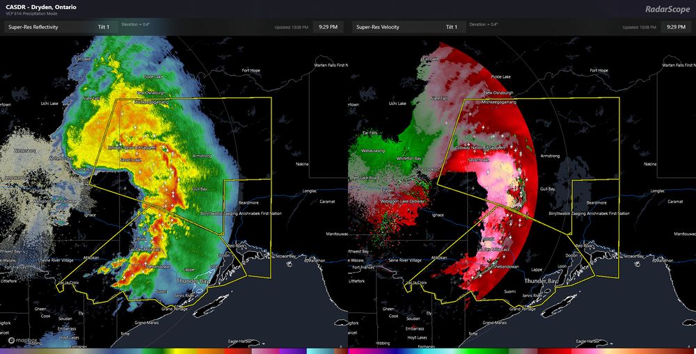
OTD in 1995, an early morning derecho hit parts of southern Ontario, resulting in a long, wide path of continuous damage. Many thousands of trees were snapped or uprooted, power lines were cut, and cottages and barns were heavily damaged. The storm's progression on radar is shown below. 1/3 #ONstorm
15.07.2025 21:46 — 👍 16 🔁 4 💬 1 📌 0
To be consistent with the definition of a tornado, the vortex at the surface needs to be connected to the base of a convective cloud. So either pyroCu or pyroCb. That can be quite difficult to determine. But yes, spectacular video that will help to better understand these vortices.
14.07.2025 23:48 — 👍 0 🔁 0 💬 1 📌 0
Official Bluesky account for NOAA's National Weather Service.
Professor at UBC; Co-chair of Global Land Programme; Sustainable land and food, Climate change; Dad of 2, Spouse of 1; Raquet sports; Max 5K runner; Learning to swim.
Professor of climate + energy policy at UCSB. Alumni of MIT, Columbia and UToronto. Hosts "A Matter of Degrees" podcast. Cuts carbon pollution! Proudly 🇨🇦 Gardener 🌱 leahstokes.com
Deputy Editor, Our World in Data
Senior Researcher, University of Oxford
Climate, energy, environment, all things data.
Climate scientist, juggler. Bikes etc. Blogging at https://www.realclimate.org - data visualization, explainers, and debunking.
Long-time network nerd, community enthusiast, music festival creator, art fan, drummer, and passionate supporter of other people’s dreams.
Founded in 2022 by Western University, the NHP aims to detect and document hail events across Canada and uncover Canada’s true hail climatology. See https://uwo.ca/nhp/ & cssl.ca.
Award-winning freelance environmental journalist and editor.
Words in: the Ecologist/Resurgence; Dialogue Earth; the ENDS Report; Ethical Corporation/Reuters; Foresight Climate & Energy: catherineearly76.journoportfolio.com/
The social media you want. Built for Canada.
Fun, private, and ethical. We're changing the way media is done around here, all without your data taking an unexpected trip south. Built on Bluesky.
https://gandersocial.ca
Hey, it’s me… JoJoFromJerz! (My real name is Jo Carducci btw). I’m a mom, a podcaster, a writer, a lover of politics and puns and a true Jersey girl through and through. Check out my Substack (my baby) on my Linktree
https://linktr.ee/jojofromjerz https://
Host of the podcast\radio show Canadian History Ehx. Author of "Canada's Main Street: The Epic Story of The Trans-Canada Highway" Sharing Canada's history daily!
Deep clean your social media, notifications, settings and more in just one click. The Washington Post’s tech columnist calls Block Party “one of the most useful tech tools I’ve come across in years”.
www.blockpartyapp.com
Views my own not employers or sponsors. Thunderstorm Scientist.
Georgian Bay Islands. Worker of numbers. Three fingered guitar player. I know almost nothing about almost everything. Jobs: dishwasher, factory worker, construction & forestry worker, bouncer, financial controller, legislative auditor, forensic accountant.
Founded in 2017 by Western University with ImpactWX, NTP aims to detect and document all tornadoes in Canada and uncover Canada’s true tornado climatology. See uwo.ca/ntp & cssl.ca.
Always fighting for the people.
Wife, Momala, Auntie. She/her.
107 Days, my behind-the-scenes account of the shortest campaign in history, is available for pre-order now.
Apocalyptic shit disturber elephant trainer -
This is the only account . 👈 If I share something it doesn’t necessarily mean I agree
Founding board member
@Freedom.press please follow https://linktr.ee/freedomofpress
@johncusack on twiiter