Grateful to receive the Christopherson Geosystems Award for Excellence in Applied Geography/ Earth Systems at the Association of Pacific Coast Geographers (APCG) Regional Meeting and the APCG Women's Network Small Grant for my research on NYC's Open Streets Program! 🗽🚶
20.10.2025 19:05 — 👍 0 🔁 0 💬 0 📌 0
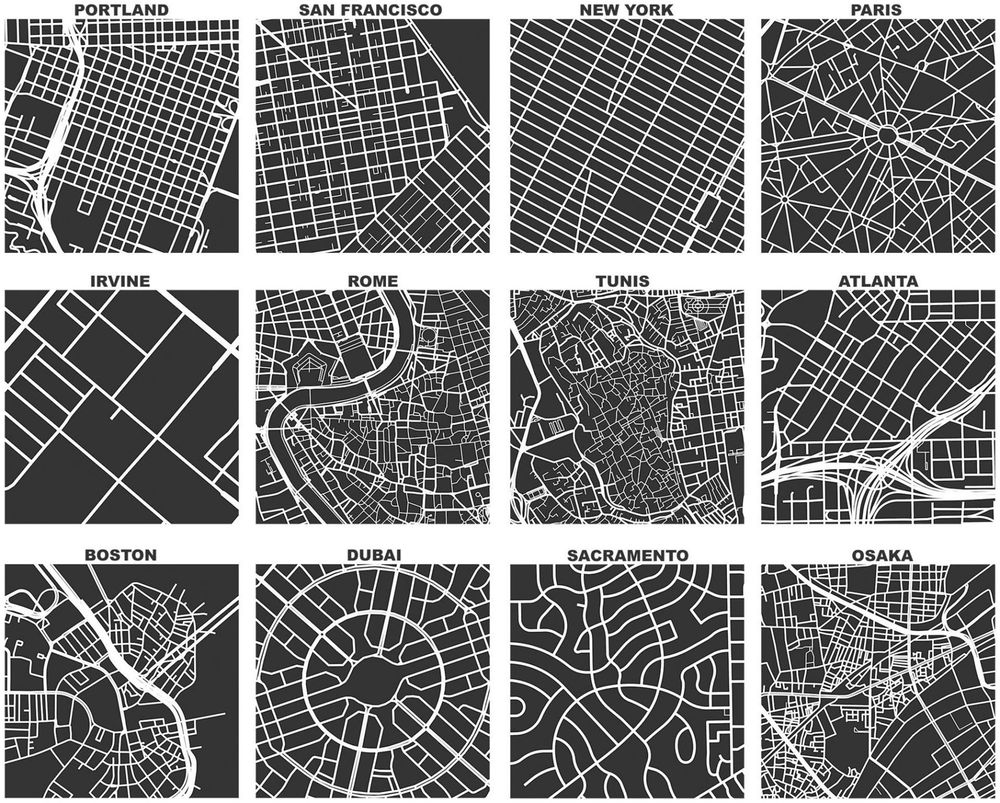
The official OSMnx reference paper was recently published open-access by Geographical Analysis: doi.org/10.1111/gean... Years in the making, it describes what OSMnx does and why it does it that way. But wait, there's more! I discuss many lessons learned in geospatial software development, including:
25.06.2025 21:17 — 👍 26 🔁 4 💬 1 📌 0

Key finding: those who were hospitalized, experienced a collision (vs near miss), or identify as female are more likely to change their biking habits afterward. This matters for post-crash support and retention strategies.
15.10.2025 02:21 — 👍 1 🔁 0 💬 0 📌 0
My work combines spatial analysis, accessibility modeling, and equity research to understand who benefits (and who doesn't) from urban interventions. Excited to connect with folks working at the intersection of urban planning, geography, and social justice! 🚴♀️🌳
15.10.2025 02:19 — 👍 2 🔁 0 💬 0 📌 0

Hi Bluesky! 👋 I'm Caitlyn, a 5th year PhD student in Geography at UC Santa Barbara. I study how cities can be more equitable and accessible for everyone—especially when it comes to walking, biking, and public spaces.
15.10.2025 02:19 — 👍 5 🔁 0 💬 1 📌 0
Geographer of human environmental systems and data.
health geography + spatial epidemiology, director @healthyregions for equity w/policy & public focus, asst prof at UIUC, #sdoh #opensource #rstats #spatialdatascience
Remote Sensing Scientist 🛰️🌍
Ph.D. Candidate at McMaster University
🇧🇷 Brazilian in Canada 🇨🇦
Communications Editor, @envdatascience.bsky.social
More:
https://about.me/ricardobarroslourenco
LSE Postdoctoral Fellow, Department of Geography and Environment | Political, Regional, and Gender Economics.
https://elenarenzullo.weebly.com/
HPC Software Engineer @luxprovide.bsky.social; Lead Spatial Data Scientist with Mobility, Health, & Climate applications; AI/ML; worked at @liser.lu and #UZH; PhD at #GeoVISTA at #PennState / Twitter accounts: @ek_geog
https://sites.google.com/view/ekgeog
Assistant Prof at Northeastern University London | urban data | computational social science | economic geography | networks
San Francisco 🌁
City Planning, Sustainable Transportation, Spatial Science. Union Member. Assistant Professor. Banner by Bellows.
South West Edinburgh 20 Minute Neighbourhoods
📍#Edinburgh
Positive, sustainable changes. Live well locally. #streetsNOTroads
🚲FREE e-bike & e-cargobike hire: sw20.info
🛠️Tool Library: @sw20etl
🏃♀️Helped setup: Kids Park Run @ Hailes Quarry Park
PhD Student @ University of Glasgow, Scotland, UK. Interested in Human Mobility, Traffic & Transport Science, Infrastructure, and Climate.
she|her - geographer...anti-racist, decolonial, feminist scholar, who can be a bit sweary. 🏳️🌈🏳️⚧️
Co-facilitator of the Embodiment Lab. | Associate Professor at UDelaware/unceded lands of the Lenape Peoples: https://sites.udel.edu/lnaylor
Assistant Professor in Data Science
Northeastern University London
Associate Professor @USC • Nonresident Senior Fellow @Brookings • Urban Networks • Geospatial Data Science
Web: https://geoffboeing.com/
LinkedIn: https://linkedin.com/in/gboeing/
Advisor | Technologist | Marketer | 🌎 Geographer | Geospatial | GIS | Former ESRI Executive | Earth Champion | Meditator | Never Trump 💙
Owner of Spatial Spirits -> www.spatialspirits.com
LinkedIn -> https://www.linkedin.com/in/lindacstevens/
GIS Faculty, Centre of Geographic Sciences (COGS); Fellow, Royal Canadian Geographical Society; co-Director, Esri Canada Centre of Excellence (COGS). My posts
Just getting started on bluesky
Astronaut photos-of-Earth maps: https://isspix.com/MapTourHowTo
Esri Director of Imagery and Remote Sensing. Pixel pusher. Community builder.
Product Manager at Esri | Interests #GIS, #HealthGIS, #Maps, #DataViz
Senior Product Manager of Mapping & Cartography @ Esri. Previously @washingtonpost.com and National Geographic. Map-maker and geographer. https://linktr.ee/tierneymaps
Cartography • Geo-visualization • Geo-Scientist • Esri
Keynote speaker • Rock climber • behance.net/sarahbellmaps
Data, maps, and satellite imagery 🛰🌻🔭
viewsfromabove.bradyafrick.com
Mountains and websites; maps and birds; context collapse. Projects: https://subject.space/. Work: Data, research and technology for investigations @bellingcat.com. Personal account, posts/opinions are my own. NYC/Amsterdam via Oregon.