Metallic (specular) shading best matches for a cinder cone.
06.02.2026 13:49 — 👍 4 🔁 0 💬 1 📌 0
@fikgm.bsky.social
Earth Science Watcher in Japan. Master of Geology and None. I am myself, not employers.
Metallic (specular) shading best matches for a cinder cone.
06.02.2026 13:49 — 👍 4 🔁 0 💬 1 📌 0

Nice
www.geoanalyst.org/wp-content/u...

Very interesting paper from China. They drilled two 10-km holes in 2025 and found hydrocarbon from that depth.
Zhu & Huang (2026) Comm. Earth Environ.
Ultradeep drilling beyond 10 km revealing new insights into Earth systems and resources
www.nature.com/articles/s43...

Diagram: Structure of the Deep Earth - by Fumihiko Ikegami
ikegami.substack.com/p/diagram-st...
The figure I've posted before + A bit of additional notes.
geoign/Geoscience_Figures: My original scientific figures for Geosciences github.com/geoign/Geosc...
Adobe Illustrator .ai file is also available for editing. CC BY-NC 4.0 License.

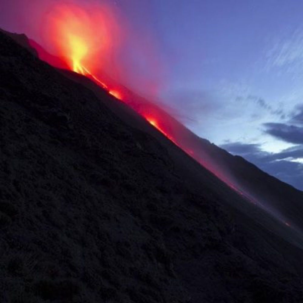
Some impressive eruption photos (between 2004-2025) from Kirishima Geopark
www.facebook.com/media/set?va...
English version! The colors of the mantle are based on the actual mineral colors (except lithospheric mantle). If you have any idea or suggestion, let me know!
26.01.2026 09:41 — 👍 7 🔁 1 💬 0 📌 1

Holiday drawing. (Don't worry. I'll create the English version too.)
25.01.2026 12:38 — 👍 4 🔁 1 💬 0 📌 1🍞🌋
24.01.2026 23:39 — 👍 1 🔁 0 💬 1 📌 0
The list of the past eruptions of Yakedake in the recent 10000 years, by Geological Survey of Japan. (Google Translated image attached)
gbank.gsj.jp/volcano/cgi-...
Very active in the past, but not in the recent time.

JMA has raised the alert level for Yakedake volcano in Japan due to the increased seismicity as well as the tilt change suggesting an edifice inflation. (Google Translated Image attached)
www.jma.go.jp/bosai/volcan...

Substack banner
Where Volcanoes Form on Earth?
open.substack.com/pub/ikegami/...
Many textbooks are still stuck at the level of understanding from the formative era of plate tectonics—over 50 years ago. In this article, I organize where on Earth volcanoes occur.
I wrote this article in Japanese back in the New Year and now it is also available in English at my substack. I hope some people find it useful.
14.01.2026 09:04 — 👍 3 🔁 0 💬 1 📌 0
Links to Geology-related Open GIS Data
open.substack.com/pub/ikegami/...


What happens in my mind when I "read" the topographical contours.
1→2. Compute the Slope (Focus onto the dense-sparse of the contour lines).
2→3. Integrate the Structure (Track the ridges and valleys).
3→4. Synthesize the Terrain. (Overlaying data to build the 3D mental model.)

Million years of geology in Ryukyu Islands, explained in single image.
14.01.2026 06:00 — 👍 2 🔁 0 💬 0 📌 0


A magnificent ocean sediment transport from Yangtze River to Okinawa Trough is seen today. It is probably due to the strong westerly seasonal wind these days.
weather-models.info/latest/himaw...


Seismotectonics of Hokkaido, the collisional area between NE Japan and Kuril arcs.
GEBCO, AW3D30, GSHHG, GlobalCMT (M>4, 1991-2020), Uchide (2022)(GSJ, AIST), JMA Unified Hypocenters (1998-2021, D<20 km), Seamless Geological Map (GSJ, AIST), Volcanoes and Calderas (GSJ, AIST)
Dear US citizens, we can't wait another 3 years for you to fix your government.
03.01.2026 15:22 — 👍 6 🔁 0 💬 0 📌 0And in case if you prefer easy vector contours in one file, use this geopackage file I made.
drive.google.com/file/d/1wSZd...

The download page of USGS's slab2 dataset looks gone.
www.usgs.gov/data/slab2-a...
Here is the alternative download link. I downloaded it in May.
drive.google.com/file/d/1lrP1...


JAMSTEC R/V Kaimei is livestreaming from Mariana's NW Rota-1 volcano right now...
www.youtube.com/live/hIb3QTz...

Geological Survey of Japan has released the raw drone videos of the eruption of Shinmoedake back in July.
storage.repository.aist.go.jp/1104/index.h...
DJI_20250703140503 has the footage of the most intense part of the eruption.


Same igneous bodies but in a different form. Not far from the previous outcrop.
21.12.2025 08:07 — 👍 12 🔁 0 💬 0 📌 0


Igneous mafic-silicic something. Don't ask me what was happened here in 120 Ma tonalite. Shikanoshima, Fukuoka, Japan.
21.12.2025 08:04 — 👍 42 🔁 6 💬 2 📌 1I am pretty impressed to Gemini 3. It is the first AI I am scared of. We dont probably need human researchers to find a scientific question anymore. Only lab rats and field explorers will survive this major extinction. Good luck.
21.11.2025 06:55 — 👍 1 🔁 0 💬 0 📌 0Meanwhile, people in the area is advised to be prepared. Even JMA mentions the possibility of an even larger earthquake in the next few days (which advice is based on the past events like 1992 in the region).
www.jma-net.go.jp/morioka/jish...
I really really wish everyone in the subduction zone around the world has this. It is the best thing that Japan has developed in the past decades.
11.11.2025 01:49 — 👍 11 🔁 2 💬 0 📌 1It could be the sort of aftershocks, but some seismologists speculate that the event (which is the part of an earthquake swarm) is the part of a M8-class slow slip event which also happened in the region in 1992. The area is historically very active.
11.11.2025 01:46 — 👍 2 🔁 0 💬 2 📌 0The underwater seismometer network is so great, as evidenced from yesterday's EQ off-Tohoku.
Reposting unofficial visualization by x.com/kotoho76/sta...