its
06.07.2025 18:06 — 👍 1 🔁 0 💬 0 📌 0

Every scientist should have a page to showcase their work, vision, and mission. Initially, I thought that only celebrities could have personal websites. However, with the overwhelming noise on social media, it has become essential for every professional to have their own space.
jadsonjall.com
16.06.2025 14:39 — 👍 120 🔁 25 💬 9 📌 3

A knitted toilet roll/toilet tissue cover
I’m reminded of …
knittingbypost.com/wp-content/u...
19.06.2025 21:16 — 👍 0 🔁 0 💬 0 📌 0
Yes, the campaign has now paused until the austral summer brings calmer weather, earliest likely return is November.
16.06.2025 22:37 — 👍 0 🔁 0 💬 0 📌 0

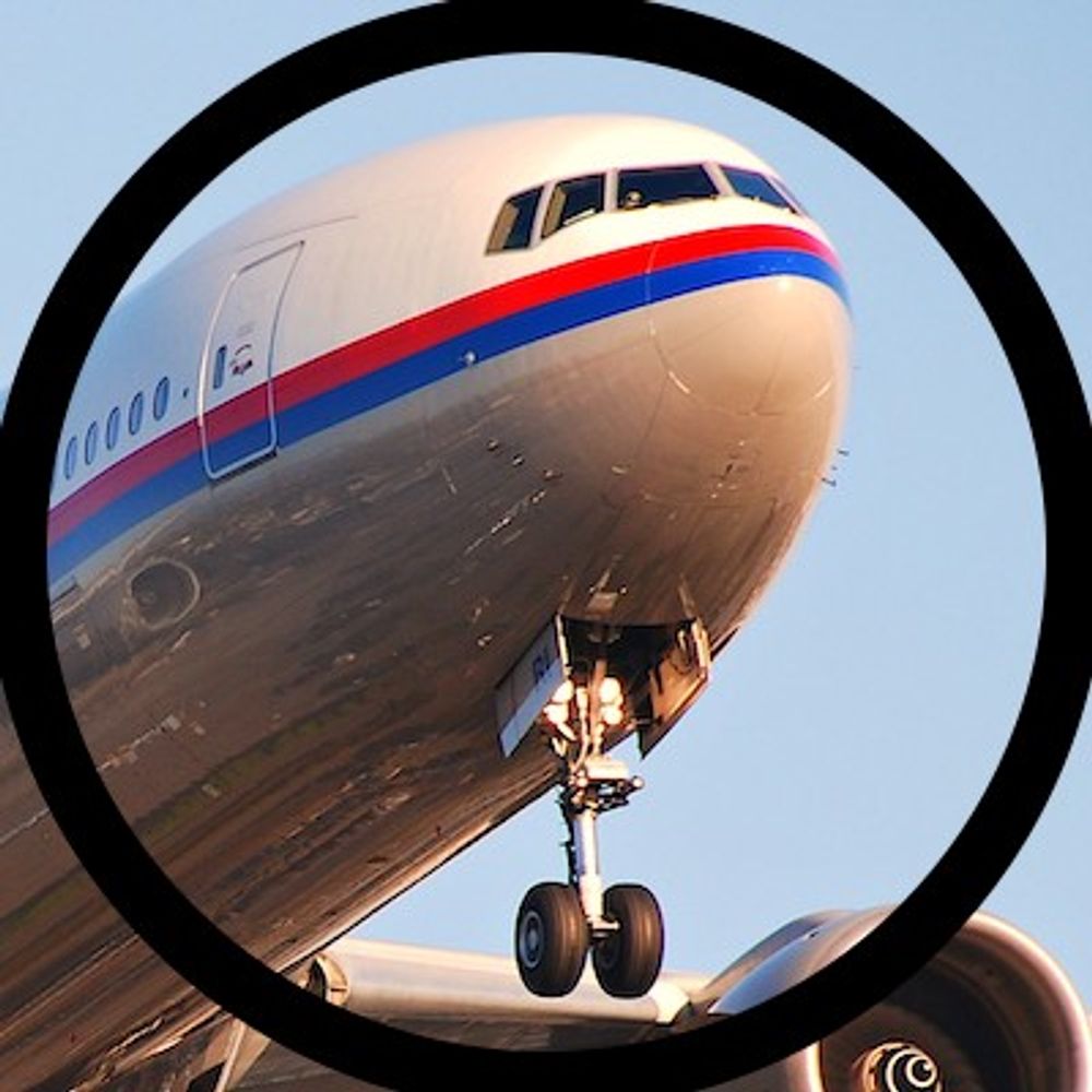
The super soaraway Sun incorrectly states ‘The jet mysteriously vanished from radar on March 2, 2014, while flying to China with 239 people on board and has never been found.’
Takes only 3 paragraphs for Murdoch’s super soaraway Sun to illustrate its journalistic incompetence.
MH370 disappeared from radar screens on 7th March, not 2nd.
04.05.2025 22:11 — 👍 1 🔁 0 💬 0 📌 0
#stopdeepseamining
#defendthedeep
@deepseaconserve.bsky.social
@greenpeaceusa.bsky.social
@deepseadawn.bsky.social
@missionblue.bsky.social
@deepstewardship.bsky.social
@schmidtocean.bsky.social
@oceanandice.bsky.social
#MarineLife 🦑
27.04.2025 02:08 — 👍 21 🔁 16 💬 0 📌 0
The Malaysian comms on the conduct of Ocean Infinity’s search are becoming even less coherent than when
Hishammuddin was running the ministry.
17.04.2025 07:02 — 👍 0 🔁 0 💬 0 📌 0
Described on Facebook as ‘An update to the families from the MAS Family Support Centre, Malaysia Aviation Group’
So, not Ocean Infinity, not Malaysian Ministry of Transport (or AAIB-MY).
What authority can this entity provide on the matter?
17.04.2025 06:43 — 👍 0 🔁 0 💬 1 📌 0
Two AUVs? One down as unserviceable during the quoted four hour period?
Four days? I guess toeing some line on reporting only on activity as covered by an agreed contract.
17.04.2025 06:36 — 👍 3 🔁 0 💬 1 📌 0
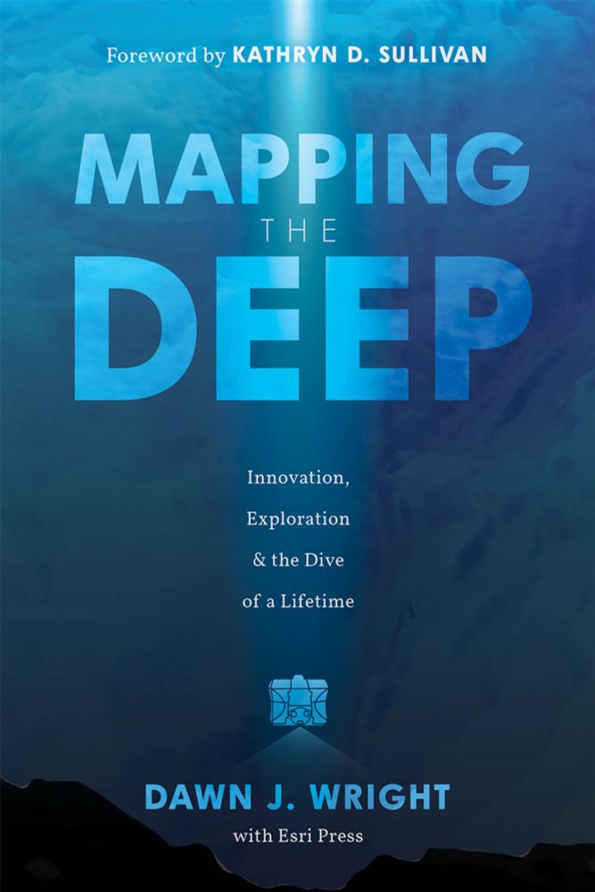
Mapping the Deep: A Book Talk with Dawn Wright | College of Earth, Ocean, and Atmospheric Sciences
Coming up MONDAY! Mapping the Deep, a book talk with Deep-sea Dawn, @deepseadawn.bsky.social!
Details and registration here: ceoas.oregonstate.edu/mapping-deep
04.04.2025 17:46 — 👍 10 🔁 3 💬 0 📌 0
🌊 ⚒️
02.04.2025 03:19 — 👍 54 🔁 23 💬 0 📌 0
Certainly, he & I correspond regularly.
01.04.2025 08:05 — 👍 1 🔁 0 💬 0 📌 0
No Armada vessel has a crane or deep recovery winch system as might be necessary to recover anything that’s too large for an ROV to lift. A vessel such as IP or any deep water cable laying/intervention vessel may be necessary.
31.03.2025 10:08 — 👍 2 🔁 0 💬 1 📌 0
I don’t believe there is a need for other subsea eqpmt, an AUV can perform hi-res SSS to optical/visual passes over an AoI.
E.g. A78-07 conducted work in the Clarion-Clipperton Zone (DSM) last summer & its tracklines were so close to suggest it was nav-aiding its AUV in visual acquisition.
31.03.2025 10:02 — 👍 2 🔁 0 💬 1 📌 0
OI’s payload integration lead stated that A86-01 is headed to Europe. A86-02 is already on the water & has conducted sea trials. A86-03 is also on the water but yet to be ‘switched on’!
31.03.2025 09:55 — 👍 2 🔁 0 💬 2 📌 1
YouTube video by sk999 sk999
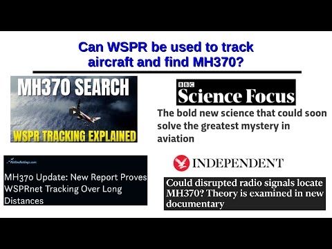
Can WSPR be used to track aircraft and find MH370?
Victor Iannello
Steve Kent has published an excellent video explaining why WSPR tracking of MH370 is complete rubbish. He supplies the scientific rigor that is absent in the WSPR proponents' papers.
m.youtube.com/watch?v=_Uil...
26.03.2025 01:01 — 👍 2 🔁 2 💬 2 📌 0
Might be important, every now-and-again, to reiterate that it’s not WSPR that is the problem but the idea set out as GDTAAA that the WSPR archive can be regarded as a big data repository, mined, & processed to identify aircraft tracks.
GDTAAA is smthg of a mouthful, though.
26.03.2025 08:53 — 👍 0 🔁 0 💬 1 📌 0
That bathymetry image layer originates from the GMRT web map service. It can be configured as a KML object, loaded on demand in Google Earth.
26.03.2025 08:47 — 👍 0 🔁 0 💬 1 📌 0
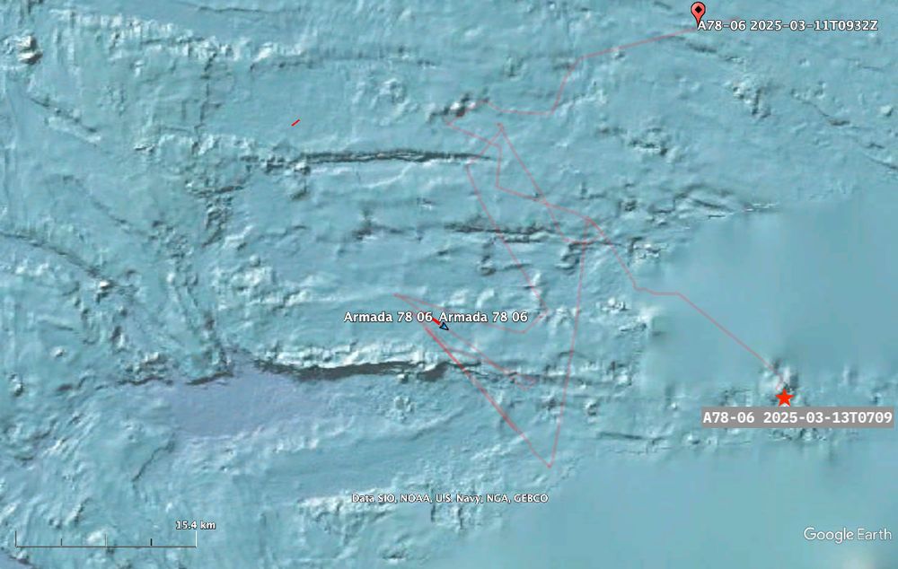
This image depicts seafloor bathymetry (depth), compiled from GEBCO sources, showing mix of 30-50m resolution detail &, to right/east side, the low resolution 'blur' derived from SRTM.
The canyons & escarpments present a challenge to acquisition of side scan sonar imagery. An AUV will tend to navigate away from obstacles while it can be 'tended' with navigation assistance from the vessel to work difficult areas.
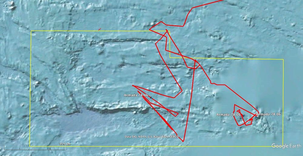
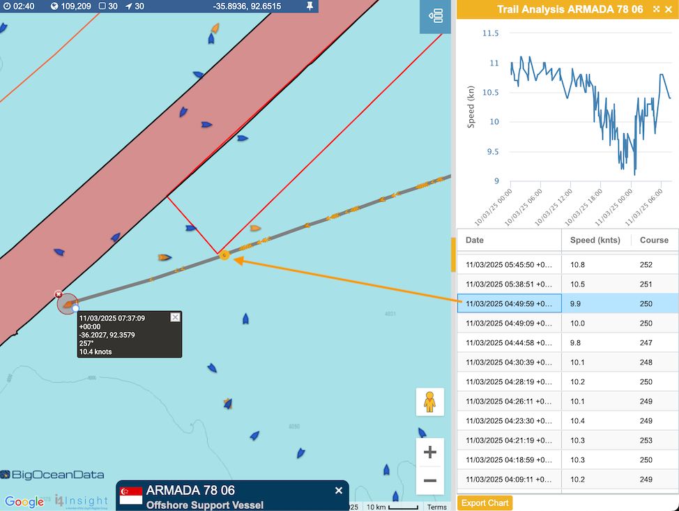
This image shows Armada 78 06 track (red) over the past three days. While the position is AIS derived, it is relayed via satellite & coverage is irregular thus sharp changes in direction may not be entirely accurate. The vessel track provides a proxy for AUV operations: the AUV launch, periodic comms/nav checks, & recovery can be discriminated as progress continues. The area of interest bounded in yellow, showing the canyons & escarpments, lies to the east of vessel track with the AUVs traversing the area along track lines east-west. The bounded area is approx 1,500km²: consistent with 4 days mission carried out by 3 AUVs.
Ocean Infinity's Armada 78 06 vessel continues its search for the seafloor debris field of #MH370. Images below show the broader features of the present search & A78-06's track as it follows AUVs. The AUV endurance will dictate recoveries over the next 24hrs.
Refer to ALT text for more detail.
14.03.2025 11:56 — 👍 3 🔁 2 💬 1 📌 0
This image depicts seafloor bathymetry (depth), compiled from GEBCO sources, showing mix of 30-50m resolution detail &, to right/east side, the low resolution 'blur' derived from SRTM.
The canyons & escarpments present a challenge to acquisition of side scan sonar imagery. An AUV will tend to navigate away from obstacles while it can be 'tended' with navigation assistance from the vessel to work difficult areas.
This image shows Armada 78 06 track (red) over the past three days. While the position is AIS derived, it is relayed via satellite & coverage is irregular thus sharp changes in direction may not be entirely accurate. The vessel track provides a proxy for AUV operations: the AUV launch, periodic comms/nav checks, & recovery can be discriminated as progress continues. The area of interest bounded in yellow, showing the canyons & escarpments, lies to the east of vessel track with the AUVs traversing the area along track lines east-west. The bounded area is approx 1,500km²: consistent with 4 days mission carried out by 3 AUVs.
Ocean Infinity's Armada 78 06 vessel continues its search for the seafloor debris field of #MH370. Images below show the broader features of the present search & A78-06's track as it follows AUVs. The AUV endurance will dictate recoveries over the next 24hrs.
Refer to ALT text for more detail.
14.03.2025 11:56 — 👍 3 🔁 2 💬 1 📌 0
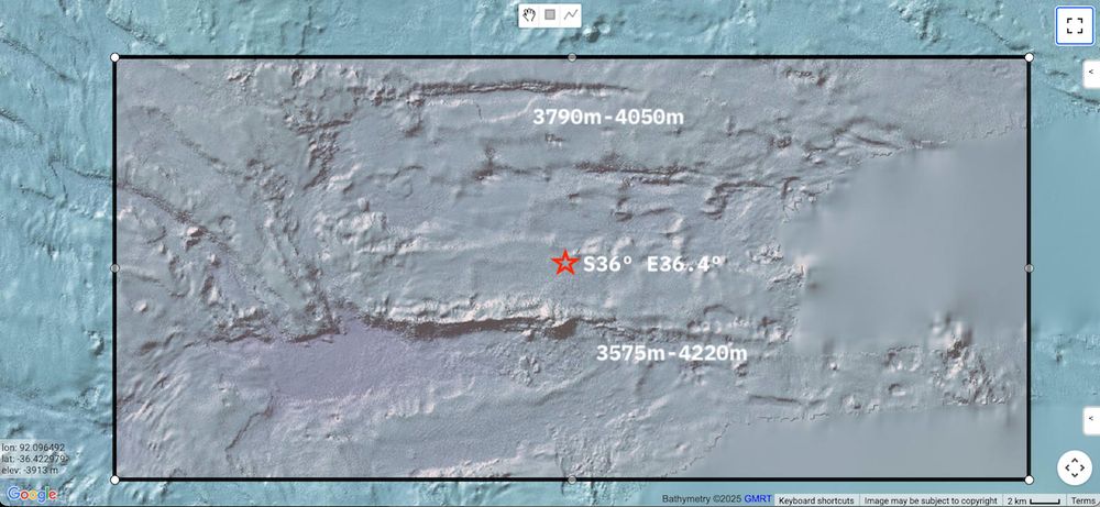
Area of Indian Ocean seafloor approx 64km east-west, 36km north-south centred around latitude S36.4º, longitude E92.0º.
Vessel track depicted as red line. Vessel manoeuvring to launch and conduct navigation checks with AUVs operating just above seafloor.
A brief update on progress by Armada 78 06 for #MH370 search this morning, 13th March.
AUVs continue to acquire seafloor imagery using side scan sonar over this particularly difficult region.
Note the, apparently, blurred areas in the image - these are low res from SRTM dataset, not local MBES.
⏹️
13.03.2025 08:15 — 👍 2 🔁 0 💬 0 📌 0
Bathymetry information & imagery collated from GEBCO catalogue, vessel track via X/labratsr from BigOceanData.
12.03.2025 10:10 — 👍 1 🔁 0 💬 0 📌 0
While the side scan sonar technology has not developed significantly in the intervening time since 2018, AUV navigation capabilities & endurance are much improved.
The focus continues on previously surveyed areas where imagery is assessed to deliver low probability of detection.
⬇️
12.03.2025 10:10 — 👍 1 🔁 0 💬 1 📌 0
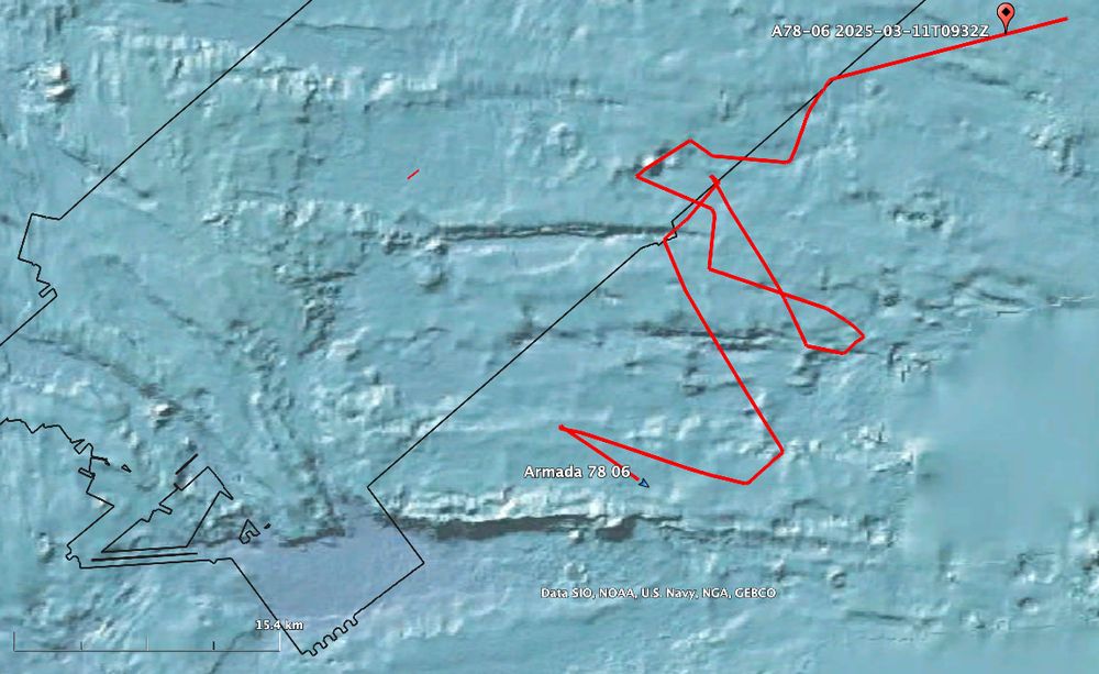
Image of Indian Ocean centred around S36.4º E92.0º, the view extent is approx 60km E-W x 36km N-S. Bathymetry, the seafloor topology, is show by shading. Past 24hrs track for Ocean Infinity's vessel, Armada 78 06, is illustrated - its approaches to the seafloor features are apparent. Autonomous Underwater Vehicles equipped with side scan sonar are launched to conduct image acquisition of the seafloor.
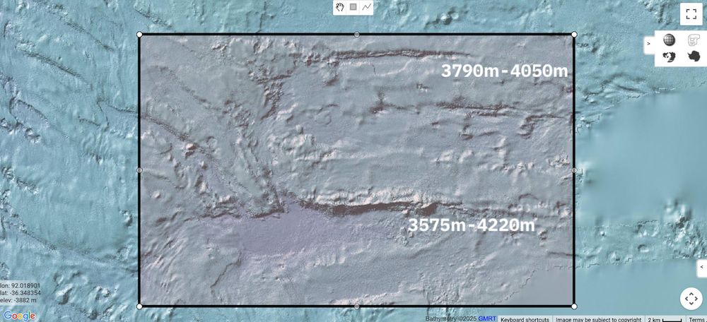
Image of Indian Ocean seafloor centred around S36.4º E92.0º, the view extent is approx 60km E-W x 36km N-S. Bathymetry, that is the seafloor topology, is show by shading. This detailed seafloor imagery exposes canyons and escarpments across which depths vary by as much as 625m.
The detailed bathymetry data was acquired during an MBES survey conducted in H2, 2014. Lateral resolution is in the order of 30m-50m (depth dependent).
Ocean Infinity's 2nd 'swing' to locate #MH370 underway. The bathymetry for the present work area shows E-W oriented escarpments.
Black boundary line depicts the extent of Ocean Infinity's 2018 seafloor search campaign.
Vessel track & bathymetry, centred S36.4º E92.0º, view approx 60km x 36km.
⬇️
12.03.2025 10:10 — 👍 2 🔁 1 💬 1 📌 0
I'd use the word 'contrived' rather than predicted. The Blelly-Marchand story involves much rationalising for what a pilot would do.
Whatever happened to 9M-MRO, rational thought is least likely to describe what, why, or why.
11.03.2025 09:38 — 👍 1 🔁 0 💬 1 📌 0
Authoritative commentary concerning the search for #MH370 can be read at mh370.radiantphysics.com.
11.03.2025 09:17 — 👍 1 🔁 0 💬 0 📌 0
At this time, it is not clear whether A78-06 will continue to Cape Town or stop again to acquire side scan sonar data at another location in the wider area of interest.
H/T LabratSR at X for access to tracking from Big Ocean Data
⏹️
11.03.2025 09:12 — 👍 1 🔁 0 💬 1 📌 0
Map showing some lines!
The grey-orange line crossing from right to left is the track of Armada 78 05 over the past 18 hrs. It passes close to the unshaded red boundary, the designated area of interest. The pink-red shaded area denotes an area previously searched.
The orange icons are long line tuna fishing vessels, the blue icons are marker beacons on the long (10s of kilometres) lines deployed by the fishing vessels.
Full view of Indian Ocean indicating the search area, circled.
At 0500Z today A78-06 reached the designated search area.
It has passed the 'block' OI described as one of its two areas of interest (the other is 'mirrored' on the northwest side of the 7th arc).
AIS broadcasts continue to report Cape Town as A78-06's destination. Ocean wide view for context.
⬇️
11.03.2025 09:12 — 👍 0 🔁 0 💬 1 📌 0
Discussion ensued suggesting brinkmanship between Putrajaya's bureaucrats & OI; that a debris field has been located; that the AIS destination has been posted in error (the ETA is infeasible).
Meanwhile A78-06 plied a track back towards the designated search area at a typical speed of 10kts.
⬇️
11.03.2025 09:12 — 👍 1 🔁 0 💬 1 📌 0
Mer et Marine est né en mai 2005 de la rencontre de journalistes et de passionnés de la mer qui avaient toutes et tous la même envie, celle d'informer, au quotidien, sur le monde maritime et les communautés humaines structurées autour.
We invent, design, build, deploy and commercialise sensors and instruments for marine and environmental science with a beneficial societal impact @nocnews.bsky.social
Columnist and chief data reporter the Financial Times | Stories, stats & scatterplots | john.burn-murdoch@ft.com
— On 👨👶 leave until July —
📝 ft.com/jbm
Scottish & European
Pro Scottish independence & EU
Bridgy Fed (https://fed.brid.gy/) bot user for the fediverse. To bridge your Bluesky account to the fediverse, follow this account.
To ask a fediverse user to bridge their account, send their address (eg @user@instance) to this account in a chat message.…
Covering tech at Bloomberg from London
Signal: @oliviasolon.13
Email: osolon2@bloomberg.net
QGIS Cloud is your powerful Cloud-GIS solution for publishing maps, data and services on the internet.
Official account of QGIS - the user friendly Open Source Geographic Information System
[bridged from https://fosstodon.org/@qgis on the fediverse by https://fed.brid.gy/ ]
Seafloor mapper, Chief Scientist of smart mapping company Esri, Oregon State U. GIS/oceans professor, EC50, cyclist, 1st Black submersible diver to Challenger Deep, builds w/LEGO, raised in Hawaii. NAS, NAE, ORCID 0000-0002-2997-7611; She/her; views mine
The College of Marine Science (CMS) at USF St. Petersburg is a leading graduate and research institute. We are experts in all things ocean. #usfcms
Advancing the power of facts, globally 🌎
Flipboard's page for news about science including space, climate change and more — from trusted sources. All posts written by human editors, especially […]
[bridged from https://flipboard.social/@ScienceDesk on the fediverse by https://fed.brid.gy/ ]
Video coordinator with @afpnews.bsky.social for China, Mongolia, Hong Kong. Previously based in 🇮🇳 🇦🇺 . Interested in international security and rural economics. Loves 🐈
Science journalist specializing in aviation & technology, featured in Netflix doc "MH370: The Plane that Disappeared," host of the "Finding MH370" podcast.
More: https://linktr.ee/jeffwise
Gaining a deeper understanding of our ocean and coastlines through ground-breaking research, collaboration and innovation! 🌊
🖥️ https://noc.ac.uk/
🔗 https://linktr.ee/nocnews
🎙️ https://linktr.ee/nocintotheblue
Journalist writing on technology, aviation & spaceflight ✍🏻 New Scientist, Economist, BBC Future, Aerospace America, ACM News, Guardian🎙️📺 BBCR4, NPR, SkyNews, Richard&Judy, OneShow.
Woodland conservation volunteer.
authory.com/PaulMarks
Australia's leading science publisher of books and journals, publishing in conservation, agriculture, health, chemistry and more.
We are not-for-profit, editorially independent and proudly part of the research community.
https://www.publish.csiro.au