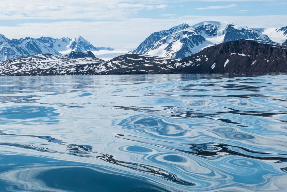
Spring is in the air
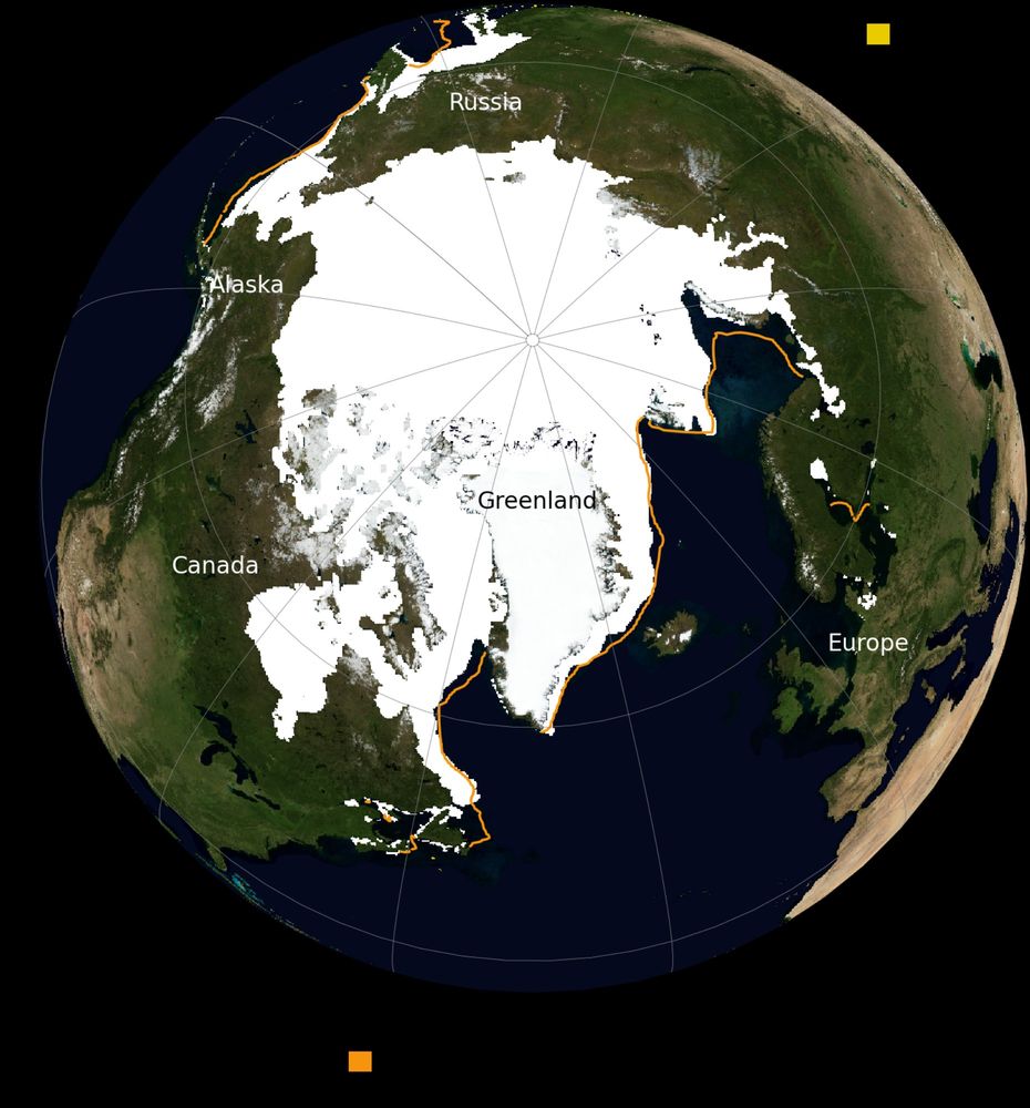
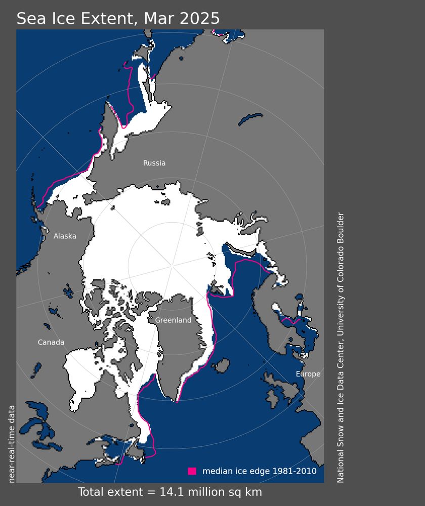
Arctic sea ice extent for March set a record low in the 47-year satellite data record. Extent was below average everywhere except the East Greenland Sea.
March Arctic sea ice extent averaged 14.14 million square kilometers (5.46 million square miles), the lowest in the 47-year satellite record and 150,000 square kilometers (58,000 square miles) below the previous record low March set in 2017.
Read our analysis: nsidc.org/sea-ice-toda...
03.04.2025 22:54 — 👍 15 🔁 5 💬 0 📌 0
🚨 March 2025 #Arctic sea ice extent was the lowest on record...
This was 1,290,000 km² below the 1981-2010 average. March ice extent is decreasing at about 2.46% per decade. Data: @nsidc.bsky.social (nsidc.org/data/seaice_...)
02.04.2025 15:19 — 👍 161 🔁 75 💬 3 📌 12
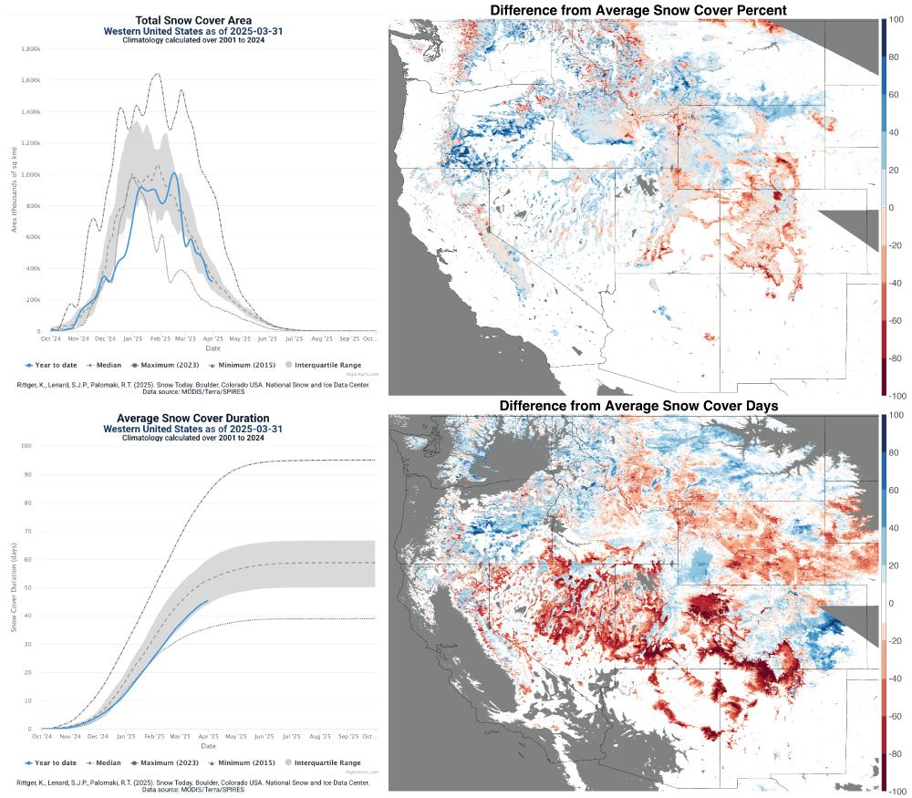
Have you checked out Snow Today yet? Now is a good time, because our latest Snow Today analysis, focusing on snow conditions in the western US in March 2025, is up!
Snow-covered area across the western US was 92% of average for March, ranking 17th in the 25-year satellite record. bit.ly/3FTHwih
03.04.2025 19:37 — 👍 12 🔁 2 💬 0 📌 1
🚨 It's official - 2025 likely observed the lowest annual maximum #Arctic sea ice extent on record!
Climate change is reshaping the Arctic, all throughout the year.
For more information from @nsidc.bsky.social: nsidc.org/sea-ice-toda...
27.03.2025 19:38 — 👍 201 🔁 93 💬 2 📌 6
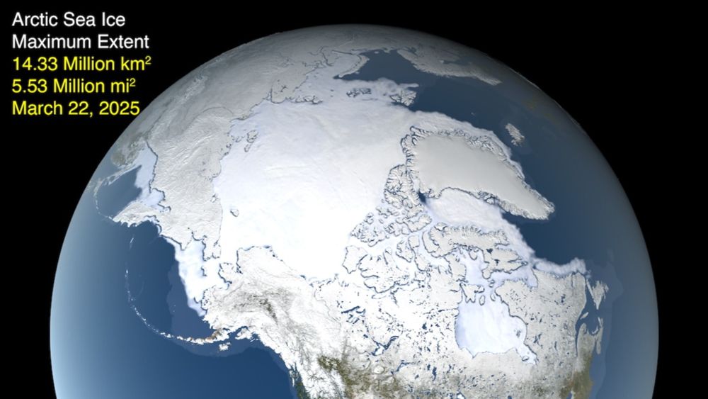
2025 Arctic Sea Ice Reaches Record Low Maximum Extent - EcoWatch
Scientists at NSIDC said that Arctic sea ice most likely reached its yearly maximum extent on March 22, at 5.53 million square miles.
“Warming temperatures are what’s causing the ice to decline. You know, sea ice in particular is very sensitive... 31 degrees is ice skating and 33 degrees it’s swimming.” ~ Walt Meier @nsidc.bsky.social
www.ecowatch.com/arctic-sea-i...
29.03.2025 03:16 — 👍 6 🔁 2 💬 0 📌 0
Arctic Sea Ice Shrinks to Record Winter Low as Earth Heats Up
The Arctic Ocean likely had the smallest winter ice cover in 47 years of satellite records this season, with just 5.53 million square miles of sea ice covering the region at its peak on March 22.
Arctic sea ice grows in winter, reaching its peak in March before starting the summer melt. This year's peak was the lowest in almost half a century. That has ramifications for the speed of global warming and for extreme weather further south. @nsidc.bsky.social www.bloomberg.com/news/article...
27.03.2025 18:55 — 👍 29 🔁 17 💬 2 📌 2
Don't forget to come support the NNA undergraduate research students tomorrow, March 28, if you're still at the ICARP Summit!
27.03.2025 16:37 — 👍 9 🔁 4 💬 0 📌 0
Thawing the mysteries of ancient climate changes
A new study from Chloe Brashear, Tyler Jones and others suggests abrupt warming events were preceded by periods of unusually stable temperatures during the last
🧊 New ice core study of the last ice age by Chloe Brashear, Tyler Jones et al. suggests abrupt warming events were preceded by periods of unusually stable temperatures. Shifting sea ice is a potential driver of the phenomenon.
Read our story: www.colorado.edu/instaar/2025...
26.03.2025 20:47 — 👍 11 🔁 6 💬 0 📌 1
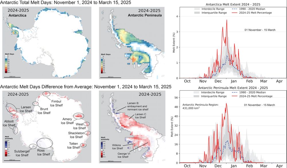
Melting on the Antarctic Ice Sheet for the 2024 to 2025 season began with above average melt extents in all regions, but melt extent dropped to nearly zero or below average from February 1 to March 15.
Read more in our latest Ice Sheets Today analysis: bit.ly/4c4iLMd
25.03.2025 21:35 — 👍 5 🔁 3 💬 0 📌 0
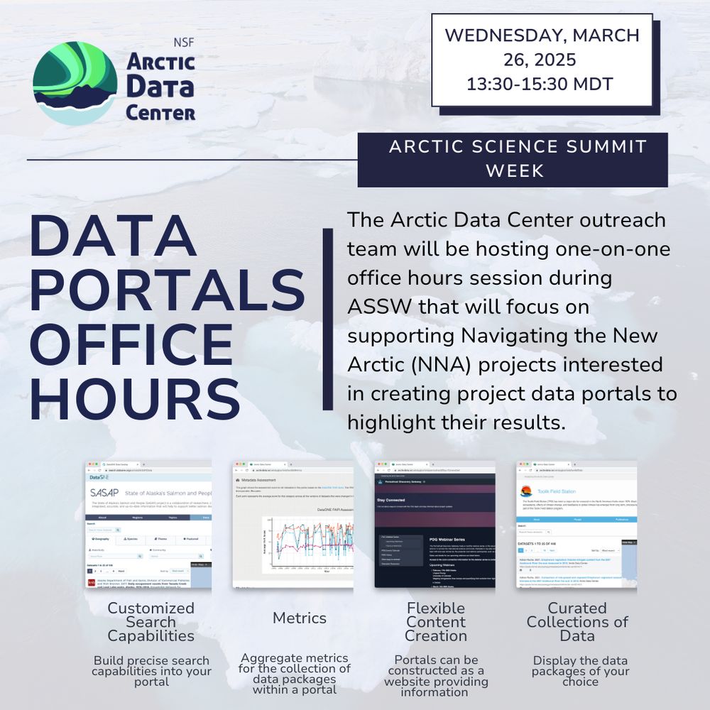
Are you involved in the Navigating the New Arctic (NNA) community? Interested in creating a webpage for your project or improving your data visualization capabilities? The ADC invites the NNA community to join our outreach team in creating customizable data portals during our office hours at ASSW
24.03.2025 16:31 — 👍 6 🔁 2 💬 0 📌 2
"The Greenland Ice Sheet is not the only important ice mass on the planet, but it plays an especially critical role at this moment in climate history," writes Twila Moon, deputy lead scientist @nsidc.bsky.social and researcher at CIRES.
24.03.2025 15:00 — 👍 9 🔁 2 💬 1 📌 0
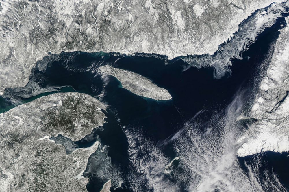
Low Ice in the Gulf of St. Lawrence
The body of water off eastern Canada is one of the southernmost locations where Arctic sea ice forms, but its extent in winter 2024-2025 was well below normal.
Sea ice has been well below average in the Gulf of St. Lawrence this winter. A recent NASA "Image of the Day," acquired by the Moderate Resolution Imaging Spectroradiometer on NASA’s Aqua satellite, shows the Gulf of St. Lawrence on March 13, 2025.
earthobservatory.nasa.gov/images/15406...
24.03.2025 13:53 — 👍 2 🔁 1 💬 0 📌 0
🚨 The annual minimum has likely passed ➡️ "On March 1, Antarctic sea ice likely reached its minimum extent of 1.98 million square kilometers (764,000 square miles), tying for second lowest extent with 2022 and 2024 in the 47-year satellite record."
See @nsidc.bsky.social: nsidc.org/sea-ice-toda...
20.03.2025 18:46 — 👍 82 🔁 25 💬 1 📌 1
Logo for Arctic Science Summit Week, 20-28 March 2025 in Boulder, Colorado.
Arctic Science Summit Week starts today #ASSW2025! The int'l mtg, focused on research cooperation & collaboration, is being held in Boulder this yr. Related meetings incl @arctictogether.bsky.social. INSTAARs are among the ~800 participants.
Info:
www.assw.info
cires.colorado.edu/news/cires-h...
20.03.2025 17:28 — 👍 5 🔁 2 💬 2 📌 1
The Arctic is warming four times faster than anywhere else on the planet. Glaciologist Twila Moon, deputy lead scientist at @nsidc.bsky.social, joins us to explain the science behind why the Arctic circle is particularly vulnerable to warming. bit.ly/3FvLnSG
20.03.2025 15:28 — 👍 6 🔁 1 💬 1 📌 0
Where do weather forecasts come from? #NOAA’s satellites, radar, and experts work behind the scenes to track storms, predict weather, and send out critical alerts. Without them, forecasting would be a lot less reliable, atmospheric scientist Kari Bowen @cires.colorado.edu explains:
20.03.2025 06:48 — 👍 41 🔁 20 💬 1 📌 1
Essentially reading if you want to understand the feedback loops accelerating the melting of the Greenland Ice Sheet, which is contributing to global sea level rise.
By Twila Moon, deputy lead scientist @nsidc.bsky.social & researcher at @cires.colorado.edu
20.03.2025 15:32 — 👍 20 🔁 8 💬 2 📌 2
Arctic ice is melting faster than expected — and the culprit could be dust
"The Arctic is changing faster than anywhere else on the planet, so the question we’re trying to ask here is: Is the Arctic going to change fast, or really fast?"
"We're trying to figure out why we’re finding all this ice in the clouds. The answer could help scientists understand the pace of Arctic melt." Scientists from the NASA ARCSIX mission are working to identify why Arctic ice is melting faster than predicted.
Learn more @space.com: bit.ly/4hGH849
20.03.2025 15:16 — 👍 4 🔁 2 💬 0 📌 0
Where do weather forecasts come from? #NOAA’s satellites, radar, and experts work behind the scenes to track storms, predict weather, and send out critical alerts. Without them, forecasting would be a lot less reliable, atmospheric scientist Kari Bowen @cires.colorado.edu explains:
19.03.2025 13:48 — 👍 37 🔁 15 💬 0 📌 1
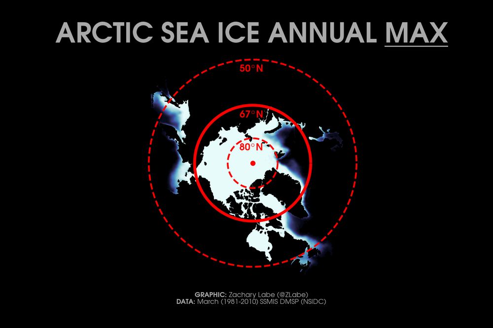
Polar stereographic map of the climatological mean Arctic sea ice concentration for March with lines denoted at latitude bands of 80°N, 67°N, and 50°N.
Transition time of year... the central #Arctic (e.g. >80°N) continues to be very cold for weeks after the annual sea-ice extent maximum. However, this maximum is reached in March due to melting sea ice in the marginal seas - look how far south they extend!
Graphic at zacklabe.com/arctic-clima... 🌊
19.03.2025 00:58 — 👍 79 🔁 16 💬 0 📌 2
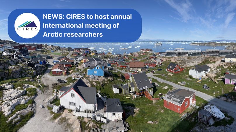
Image of houses along a rocky and green coast with floating ice visible in the water. In the top left corner, there's a blue box with the CIRES logo and white text: NEWS. CIRES to host annual international meeting of Arctic researchers
Starting Thursday, CIRES is hosting the largest event in the institute's history: Arctic Science Summit Week (ASSW), an annual meeting focused on research cooperation and collaboration in the Arctic. @colorado.edu @nsidc.bsky.social
Read more: cires.colorado.edu/news/cires-h...
18.03.2025 22:00 — 👍 9 🔁 3 💬 0 📌 0
Arctic Science Summit Week is happening this week at the University of Colorado Boulder! The conference provides opportunities for coordination, cooperation & collaboration between the scientific organizations involved in Arctic research.
Learn more: www.assw.info
18.03.2025 18:31 — 👍 1 🔁 1 💬 1 📌 0
Amazing Arctic | Big Picture Science
"We are seeing the Arctic warm much more rapidly than the rest of the planet, and we've been seeing record heat there."
NSIDC's Twila Moon joined the Big Picture Science podcast to talk about the changes we're seeing in the Arctic because of climate change. bigpicturescience.org/episodes/ama...
18.03.2025 17:59 — 👍 5 🔁 0 💬 0 📌 0
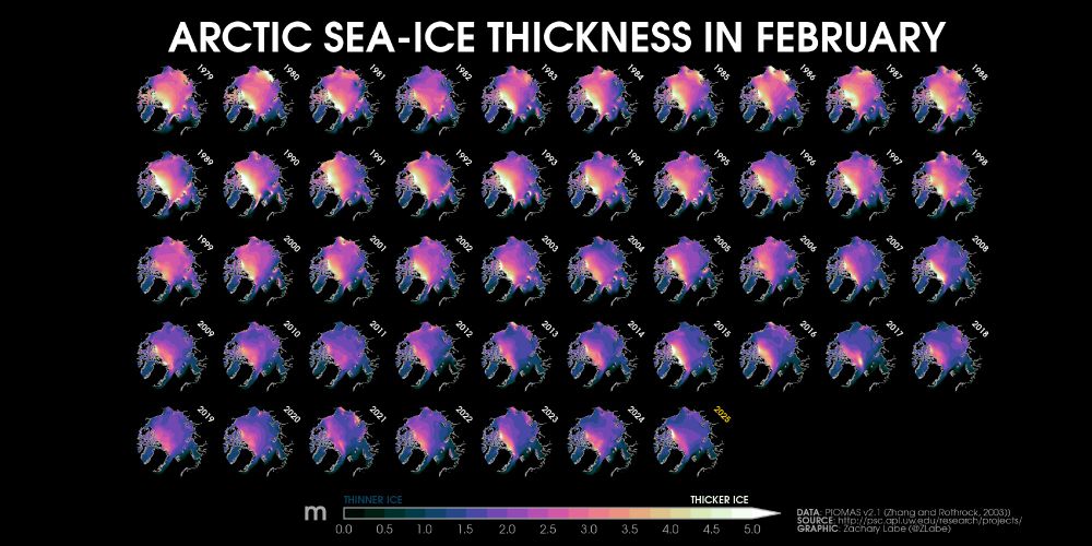
Collection of small polar stereographic maps showing the average February Arctic sea-ice thickness for each year from 1979 to 2025. There is large spatial variability, but a long-term decreasing trend. The thickness of ice ranges from 0 meters to more than 5 meters.
47 years of #Arctic sea ice thickness during the month of February...
Graphic available at zacklabe.com/arctic-sea-i...
16.03.2025 20:02 — 👍 150 🔁 44 💬 2 📌 6
Giant ice bulldozers: how ancient glaciers helped life evolve | News at Curtin
New Curtin University research has revealed how massive ancient glaciers acted like giant bulldozers, reshaping Earth’s surface and paving the way for compl ...
Researchers at Curtin University discovered that as glaciers carved through the landscape, they scraped deep into the Earth’s crust, releasing key minerals that altered ocean chemistry.
Learn how this could enhance our understanding of Earth’s interconnected natural systems: bit.ly/3Dl6t5y
17.03.2025 16:28 — 👍 15 🔁 6 💬 0 📌 0
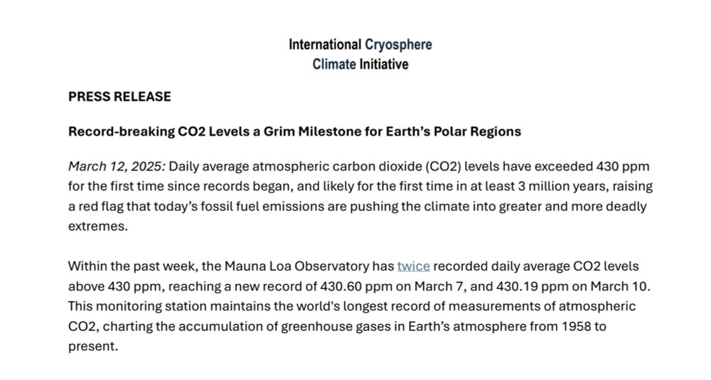
⏰ Atmospheric CO2 levels have now exceeded 430 ppm
for the first time since records began, marking a grim milestone for the future of the Earth's polar regions
Full press release: iccinet.org/media-center/
13.03.2025 08:32 — 👍 8 🔁 2 💬 1 📌 0
Covering Boulder for Axios. Formerly of the Daily Camera in Boulder, Colo.
editor | fmr. managing editor at EcoWatch | animal rights | climate | biodiversity | science | oceans | biophile | Asheville, NC
Communications specialist and science writer @cires.colorado.edu | PhD-trained geologist | personal assistant to 3x🐕 | she/her
We champion better science for future us. #openscience #kinderscience to uncover environmental & Earth solutions faster.
Polar scientist & glaciologist. Sec Gen for @igsoc.bsky.social. Trail running. Still new to this platform & figuring things out!
Taking you out of this world, every day! 🪐
Exploring the Impact of Chemistry on Air Quality and Climate
https://www2.acom.ucar.edu/
The AI-powered developer platform to build, scale, and deliver secure software.
A nonprofit news organization dedicated to sharing the knowledge of experts with the public, in accessible, trustworthy articles drawing on their research.
Free to read, without paywalls or ads.
Western Water Assessment is a university-based applied research program that addresses societal vulnerabilities related to climate and water resources.
We're a news service that helps you understand climate change and what you can do about it. Get climate solutions in your inbox: https://yaleclimateconnections.org/newsletters/
The official Bluesky for Discover Magazine.
Science that matters, for readers that matter.
🔬🧪⚗️🧫🧬🧲🧮🥼📐🌳🌍🪨⛅💧🦠
Award-winning nonprofit media outlet publishing global environmental science & news in 6 languages via bureaus in India, Brazil, Africa, Latin America, Indonesia & US: https://mongabay.com
Climate and science writer at The Associated Press, covers disasters, all sorts of science. Teaches journalism at NYU/DC. Father of 3, husband of 1. Red Sox fan.
The Navigating the New Arctic Community Office (NNA-CO) supports collaborative Arctic research to solve complex challenges.
GIS, Interactive & Printed Trail Maps, Data Books, Trip Planners, Snow, Wildfires, Gear Lists, Open Source, GDAL Evangelist. https://www.postholer.com, https://cloudnativemaps.com, https://femafhz.com
Climate journalist, teacher, professor of practice @uvaenvironment.bsky.social. Former WaPo climate writer. Views are my own. For my latest work: https://reportearth.substack.com/
The #CopernicusClimate Change Service (#C3S) & #CopernicusAtmosphere Monitoring Service (CAMS), implemented by @ecmwf.int on behalf of the @ec.europa.eu.