Remove the tag to this page. We do not approve of this association or tag
29.10.2025 03:49 — 👍 0 🔁 0 💬 0 📌 0

CAL FIRE graphic shows spooky house and share safety tips.
Spooky season is here, but fire safety is no trick. 🎃
While decorating for Halloween, remember to:
🕸 Keep exits clear
🕯 Keep décor away from candles, heaters, and lights
🚨 Double-check your smoke alarms
A safe home is the best treat of all.
#CALFIRE #HalloweenSafety #FireSmart #SpookySeason
21.10.2025 13:41 — 👍 19 🔁 7 💬 0 📌 0

NOAA Weather Prediction Center Day 3–7 U.S. Hazards Outlook for October 24–28, 2025. Heavy rain is forecast over parts of Texas and Oklahoma, with high winds expected across portions of the central and northern Plains and the interior West. The Pacific Northwest may see heavy precipitation, high winds, and significant waves, while frost or freeze conditions are possible in parts of the Upper Midwest.
The Weather Prediction Center (WPC) has updated their Day 3-7 Hazards Outlook. See more at www.wpc.ncep.noaa.gov/threats/thre...
21.10.2025 21:15 — 👍 85 🔁 17 💬 0 📌 1
Biggest weather stories for our area:
-Nice from now till late Friday, but possibility of high winds Thursday and Friday
-Very slight chance of snow Friday night
-Decent weekend
-Another chance of rain/snow Monday/Tuesday
❄️🌞🌧️
07.10.2025 03:33 — 👍 1 🔁 0 💬 0 📌 0
What items should be in your emergency kit? These 10 basic supplies could be life saving in the event of a weather emergency. Check your kit!
For more information about being prepared before inclement weather strikes visit weather.gov/safety.
#NationalPreparednessMonth #PreparednessStartsAtHome
26.09.2025 15:19 — 👍 80 🔁 23 💬 0 📌 2

Feeling Fall in the air! 🍂
Thunderstorm chances start today and extend through Thursday with high temps around 60ish. Lows are dipping into the 30s. It's time to break out the layers. Of the next 5 to 7 days, Saturday looks to be the best outside day!!!!
09.09.2025 22:21 — 👍 2 🔁 0 💬 0 📌 0

Much lower probabilities of storms today but not completely out of the picture. Tomorrow starts a lovely looking Labor Day weekend.
Locals summer (IYKYK) starts off with temps around 80, lows in the 40s. Slight chances for thunderstorms return Wednesday into Thursday, but we'll see.
28.08.2025 19:44 — 👍 1 🔁 0 💬 0 📌 0

Air resources were looking for this for a bit
Near Cisco Grove
share.watchduty.org/i/61407?ts=1...
24.08.2025 23:02 — 👍 1 🔁 0 💬 0 📌 0

Widespread lightning within striking distance of Donner Lake, Prosser, Boca, and Stampede reservoirs. Find shelter indoors if at all possible
24.08.2025 22:50 — 👍 0 🔁 0 💬 0 📌 0

FYI Sierra County
share.watchduty.org/i/61381?ts=1...
share.watchduty.org/camera/1720?...
Other small fires have been reported and listed as contained in Nevada, Placer, and Sierra counties
24.08.2025 21:51 — 👍 2 🔁 0 💬 0 📌 0

Chances of afternoon t-storms today through Saturday with highest probabilities on Friday and Saturday. If out on the water or up on the high peaks, keep an eye on the sky.
Temps will be in the 70s creeping towards 80 today and tomorrow then trending down a bit with a rebound Monday.
23.07.2025 18:41 — 👍 2 🔁 0 💬 0 📌 0
sorry, images are in reverse order 🤦🏻♀️
11.07.2025 01:05 — 👍 1 🔁 0 💬 0 📌 0


It's that time of year 😭😭😭😭
Thankfully, there are no active large fires near us. Unfortunately that doesn't mean we escape the drift. First image:air quality forecast for tomorrow 2nd image: purple air from earlier.
Time to download air quality apps for "smoke season" 😭
11.07.2025 01:04 — 👍 2 🔁 0 💬 1 📌 0


Sunday and Monday certainly have my attention for elevated fire danger, but also potential for future smoke impacts should anything large get going in British Columbia or SW Alberta #wawx #wawildfire
05.06.2025 23:08 — 👍 16 🔁 5 💬 0 📌 0

Popping off again
06.06.2025 01:18 — 👍 0 🔁 0 💬 0 📌 0

Fyi
South of our area BUT this afternoon could be active again
05.06.2025 22:26 — 👍 0 🔁 0 💬 0 📌 0
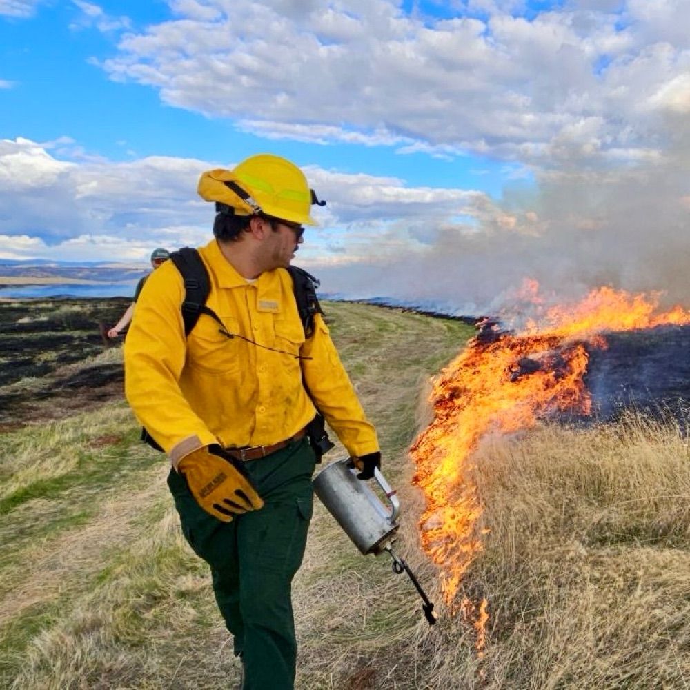
Waddle Rx Burn has finished for today, 6/3/25, however CalFire NEU and other agencies will remain in the area to monitor smoke, perimeter, and any lingering warm areas.
Sorry for the delayed information on this. I've been off BlueSky for a couple weeks. I'll try and improve post consistency here
04.06.2025 06:07 — 👍 3 🔁 0 💬 0 📌 0


Very slight indication on a few models that thunderstorms may move north towards the lake and Truckee. Again, minimal but good to be aware
04.06.2025 06:05 — 👍 2 🔁 0 💬 0 📌 0
REV updates Lake Wind Advisory (extends time and expands area to include Greater Lake Tahoe Area [CA] and Greater Lake Tahoe Area [NV], continues Western Nevada Basin and Range inc... at Sat, 17 May 2025 07:21:19 +0000 via IEMbot
Additional Details Here.
17.05.2025 07:37 — 👍 0 🔁 1 💬 0 📌 0


Wind picks up this weekend
17.05.2025 08:06 — 👍 0 🔁 0 💬 0 📌 0


So far, here are the outage situations. Two appear to be from downed trees.
Links for you
tdpud.outagemap.coop
myaccount.libertyenergyandwater.com/portal/#/Pre...
www.nvenergy.com/outages-and-...
No current restoration times available
12.05.2025 13:05 — 👍 0 🔁 0 💬 0 📌 0
Unofficial bot sharing alerts from NWS Reno NV.
This account is not monitored. Contact @wandrme.paxex.aero if needed.
TMFR Blue Sky Feed for timely and relevant regional fire/safety news in Washoe County, NV. EMERGENCIES CALL 911. NOT MONITORED 24 HOURS - Do not leave messages.
Weather Forecasts & Snow Reports ❄️⚡
This is an automated account, run by @toxic.sf.ca.us. It uses data provided by caltrans to post timely information about chain controls on Interstate 80 through the Sierra Nevada mountains.
www.chainguy.com
Promoting Fire Ecology Research, Education, and Management
fireecology.org
I monitor and report on wildfires.
News on weather, climate, oceans, fish, satellites, research & more from NOAA Communications. Official NOAA account.
NOAA provides science, service and stewardship to protect life, property & Earth's natural resources. An agency of the Department of Commerce. Join us on Instagram & Facebook. Official NOAA account.
Toward a Climate-Smart Nation. The official NOAA account for Climate.gov hosted by the Climate Program Office. Follow for #climate news, #science, #data, resources, and more!
Writing about West Coast weather as a Newsroom Meteorologist at the San Francisco Chronicle
Snow lover, Seattle sports fan, University of Washington graduate
sfchronicle.com/author/anthony-edwards/
Bay Area AMS Meteorologist since 2003 CSU/SJSU Lecturer. Formerly KIRO, KCRA, KSBY, KESQ, KNBC, Arizona Daily Wildcat & dad of twinados 👦🏻🌪️👦🏻🌪️
Official Bluesky account for NOAA's National Weather Service.
Public health experts resisting harmful policies, fighting disinformation, and defending public health from within.
Not official CDC—but close enough for transmission.
Proudly #AltGov
Tips? signal altCDC.99, email altCDCtips@proton.me or DM
Where the News Comes First. Breaking news, weather and what’s happening now in Northern California. https://www.kcra.com/
CalMatters is a nonpartisan and nonprofit news organization. We write stories about California, for Californians.
Navy Vet with a Marine Corps family. CA liberal living in conservative VA. 1960s style Women’s Rights fighting is back in vogue. Normally relay emergency info. I […]
[bridged from https://m.ai6yr.org/@BakerRL75 on the fediverse by https://fed.brid.gy/ ]
Pyrogeographer 🌲🔥, Professional Storm Chaser at Live Storms Media, Official Reporter for Watch Duty
Scrapes https://www.cpc.ncep.noaa.gov/products/predictions/814day/ for the latest 8-14 day temperatures and rain outlook
Created by @Blurangengold.bsky.social
Weather and climate scientist focused on extreme events like floods, droughts, & wildfires on a warming planet. www.weatherwest.com
California Governor's Office of Emergency Services