The talk will also be via Zoom. To attend the meeting via Zoom, members and non-members should register in advance. Members will receive a link for registration by email. Non-members should telephone 020 7434 9298 or email the Secretary (sarah@geologistsassociation.org.uk) for details.
07.10.2025 13:58 — 👍 0 🔁 0 💬 0 📌 0
Non-members are always welcome to attend for an introductory visit arranged by phoning (020 7434 9298) or emailing (sarah@geologistsassociation.org.uk) the Executive Secretary to book a place. The GA reserve the right to request a small charge for returning non-member attendance.
07.10.2025 13:58 — 👍 0 🔁 0 💬 1 📌 0

Join us at 18.00 BST on Friday 10th October at Burlington House in London for our next free talk - Thames Through Time: Cornish Flavour by Ian Mercer
This will be a hybrid event: in-person and online via Zoom. For those attending in person, tea will be served in the Lower Library from 17.30 BST
07.10.2025 13:58 — 👍 1 🔁 1 💬 1 📌 0
The GA 2025 Annual Conference at Keele University is finally over after a weekend full of interesting and varied talks, displays and field trips.
Thank you to NSGGA - North Staffs Group of the Geologists' Association and everyone involved in organising and delivering such a packed programme!
06.10.2025 17:09 — 👍 13 🔁 5 💬 0 📌 0
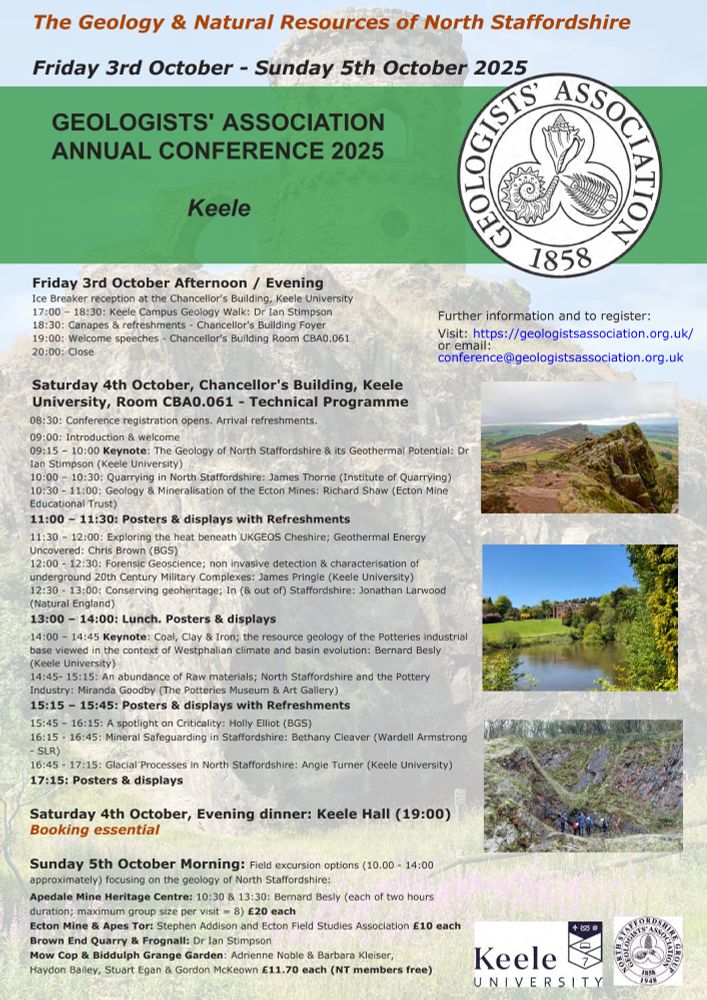
Join us tomorrow at @keeleuniversity.bsky.social for our 2025 Conference: The Geology and Natural Resources of North Staffordshire
GA members/affiliates £45, non-members £55, students £10
Just turn up on the day: registration opens 08.30 BST
Full details: geologistsassociation.org.uk/conferences/
03.10.2025 09:37 — 👍 1 🔁 2 💬 0 📌 0
Honeymoon Bay is a small bay within Coles' Bay, in the Freycinet National Park, Eastern Tasmania. The distinctive red granite is Devonian and about 390 million years old. The colour is due to the large potassium feldspar crystals in the rock, enhanced by the evening sun.
01.10.2025 09:38 — 👍 3 🔁 1 💬 0 📌 0

A rounded, rocky granite surface in shades of oranges and browns is prominent in the foreground of the image. In the background are tall eucalyptus trees beneath a clear, pale blue sky. The steel-grey sea washes directly onto the rocky surface.
Welcome to October 2025 with a colourful image of the granite coastline in eastern Tasmania from the Geologists' Association 2025 Calendar taken by Howard Anderson, which was an entry in the GA 2024 photographic competition.
01.10.2025 09:38 — 👍 4 🔁 1 💬 1 📌 0
There's still time to sign up to attend the GA 2025 Conference on Saturday 4th October at Keele University campus
Join us for a full day of talks, posters and displays on the subject: Geology and Natural Resources of North Staffordshire
Book here: geologistsassociation.org.uk/event-bookin...
01.10.2025 08:54 — 👍 2 🔁 0 💬 0 📌 0
Great photo @hypocentre.bsky.social
Fingers crossed for good weather!
Book your conference/field trip place here: geologistsassociation.org.uk/event-bookin...
30.09.2025 17:23 — 👍 2 🔁 1 💬 0 📌 0

The 58th ESTA Annual Conference
Join us at the 58th ESTA Annual Conference for two days of learning, networking, and fun!
One of our affiliated societies - The Earth Science Teachers' Association is holding their 58th annual conference next weekend at @es-ucl.bsky.social in London. Join them for two days of learning, networking, and fun!
Tickets available here: www.eventbrite.co.uk/e/the-58th-e...
06.09.2025 15:27 — 👍 1 🔁 1 💬 0 📌 1
A beautiful fossil ammonite preserved in calcite from the cliffs of Lower Lias at Charmouth, near Lyme Regis. It has been prepared from the cement stone nodule in which it was found. These Jurassic fossils are the remains of creatures that were living in a tropical sea 190 million years ago.
01.09.2025 09:57 — 👍 2 🔁 0 💬 0 📌 0

Welcome to September with a close up image from the GA 2025 calendar of a Jurassic ammonite from Charmouth in Dorset, which was taken by Gerald Lucy.
01.09.2025 09:57 — 👍 3 🔁 0 💬 1 📌 0

Dr Dean Lomax

Bob Nicholls

Front cover of the book 'The Secret Lives of Dinosaurs' written by Dean Lomax and illustrated by Bob Nicholls
The programme is taking shape with details of talks now available, including: The Secret Lives of Dinosaurs & The Adventures of a Palaeontologist – with @deanrlomax.bsky.social
The talk will be followed by a Q&A and a book signing with the author and illustrator @bobnichollsart.bsky.social
26.08.2025 16:43 — 👍 10 🔁 2 💬 0 📌 0

Event flier for the 2025 Festival of Geology
Join us and our colleagues from @rockwatch.bsky.social on Saturday 1st November from 10.30am until 4.30pm at @geolsoc.bsky.social Burlington House in London for the 2025 Festival of Geology - a free event for everyone interested in the story of Earth. Children and families welcome!
26.08.2025 16:43 — 👍 6 🔁 1 💬 1 📌 0
The deadline for entries to the GA 2025 Photo Competition is Friday 22nd August so there's still time to submit up to 3 photos for a chance to win a cash prize!
🥇£150 🥈£75 🥉£50
Email entries to: photocomp@geologistsassociation.org.uk
Full details: geologistsassociation.org.uk/photocomp_en...
16.08.2025 16:59 — 👍 5 🔁 3 💬 0 📌 0
Order yours now - email the SchoolRocks! box co-ordinator, Dr Haydon Bailey at schoolrocks@geologistsassociation.org.uk
For more information, including an introductory video, visit the Geologists' Association website: geologistsassociation.org.uk/schoolrocks/
10.08.2025 15:50 — 👍 2 🔁 1 💬 0 📌 0
Hire a box for up to 10 weeks with a £40 returnable deposit. All we ask is that you cover the price of the return postage (£14) but we may be able to deliver/collect for free
We are now taking bookings for our Year 3 and Year 6 boxes for the new school year in September 2025
10.08.2025 15:50 — 👍 1 🔁 0 💬 1 📌 0
Our boxes have been designed for the KS2, Yr3 'Rocks & Soils' and Yr6 'Evolution & Inheritance' elements of the National Curriculum
Boxes contain lots of specimens for hands-on learning plus you have access to the teaching plans, learning activities and resources produced by the SchoolRocks! team
10.08.2025 15:50 — 👍 1 🔁 0 💬 1 📌 0
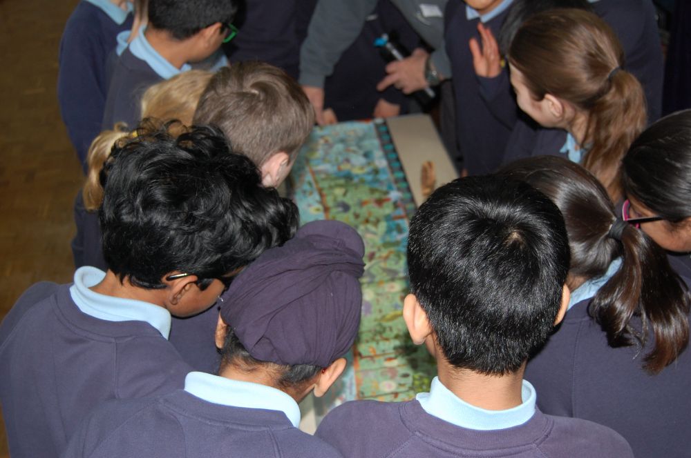
SchoolRocks! workshop fun with a geological timescale and loads of fossils. Photo by St. Mary’s C of E Primary School, Amersham.
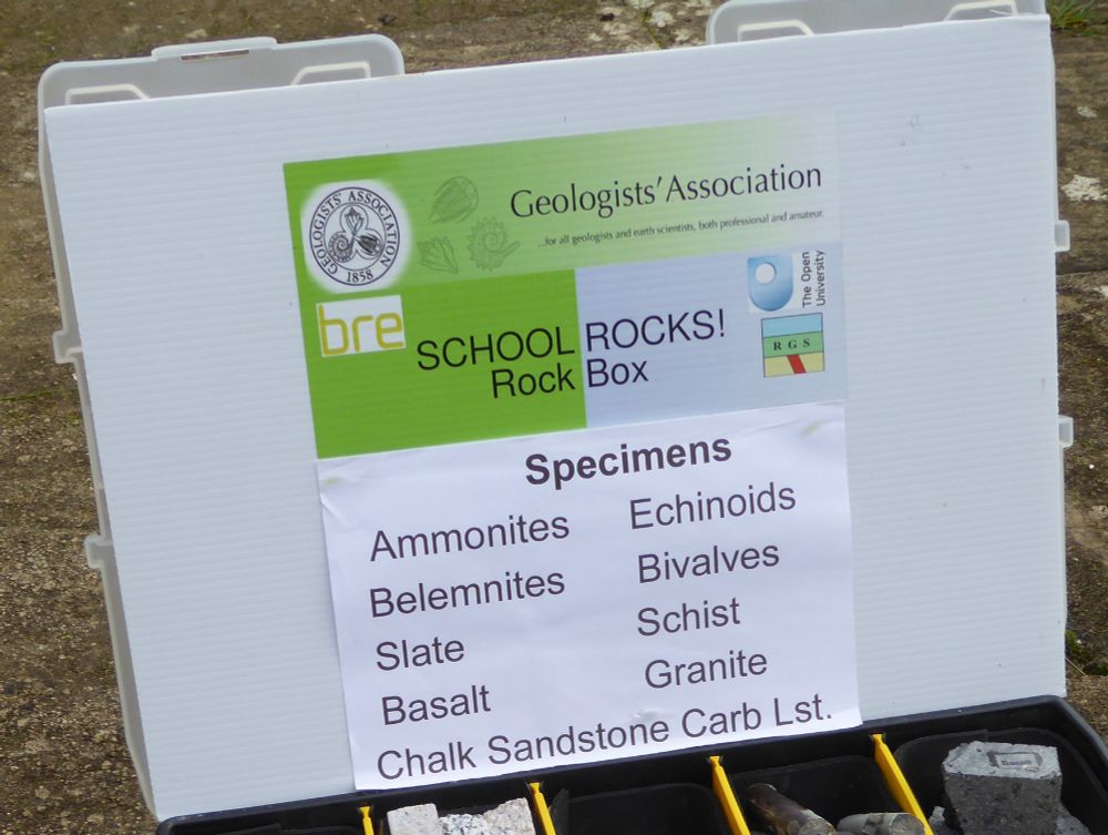
The Geologists' Association SchoolRocks! rocks and fossil boxes are supported by Reading Geological Society (RGS), the Building Research Establishment (BRE) and The Open University.
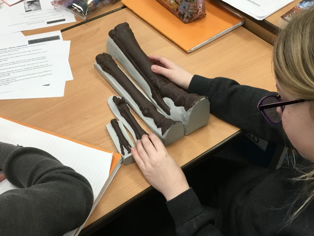
School pupils examining replica fossil horses hooves from the SchoolRocks! Year 6 Evolution box. Photo by Holy Trinity C of E School, Marlow
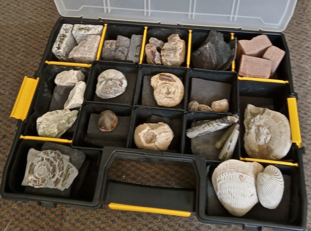
The SchoolRocks! Year 3 box. Each box contains child hand-sized specimens of igneous, sedimentary and metamorphic rocks. There are also fossils, hand lenses and some small fossils or minerals to be given to the children. In fact, everything you need to teach the Rocks and Soils section of the National Curriculum Year 3 Science.
Did you know that the GA have boxes of fossils, rocks and minerals we hire out to UK schools and home educators for the study of the Key Stage 2 earth-science curriculum?
We have reached over 10,000 children across 113 schools and 7 home-educator groups as far afield as Elgin, Pembroke and Somerset
10.08.2025 15:50 — 👍 34 🔁 14 💬 2 📌 0
There's still time to enter up to 3 photos on any geological topic into the GA 2025 Photo Competition. It's free to enter and you could win a cash prize of up to £150!
Closing date: 22 August
For full details visit our website: geologistsassociation.org.uk/photocomp_en...
01.08.2025 10:14 — 👍 0 🔁 0 💬 0 📌 0
On the coast of County Antrim is the Giant's Causeway, a World Heritage Site for the importance of its geology. The remarkable basalt columns were formed about 60 million years ago as basalt lava cooled and contracted.
01.08.2025 10:14 — 👍 1 🔁 0 💬 1 📌 0
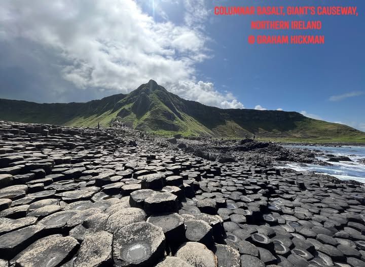
Columnar Basalt, Giant's Causeway, Northern Ireland. On the coast of County Antrim is the Giant's Causeway, a World Heritage Site for the importance of its geology. The remarkable basalt columns were formed about 60 million years ago as basalt lava cooled and contracted. Photo: Graham Hickman
Welcome to August with a dramatic image from the Geologists' Association 2025 calendar of Columnar Basalt, Giant's Causeway, Northern Ireland taken by Graham Hickman, which won first prize in the GA 2024 Photographic Competition.
01.08.2025 10:14 — 👍 8 🔁 0 💬 2 📌 0
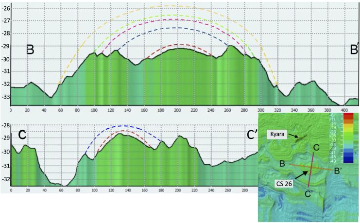
Cross-sections through CS 26 adjacent to wreck of SS Kyara (126 m long) viewed in Fledermaus to estimate minimum height of dome-shaped structure. Profile B–B′ height is 7 m at 280 m across. Profile C–C′ is 9 m high at 177 m across. Note vertical colouring bands below bathymetric profile are projected down from the depth at the sea floor and have no stratigraphical or structural significance. Coloured dashed lines are reconstructions of correlations between bedding ridges that can be traced around the circular structure, and are concordant with the exhumed core, along profiles B–B′ and C–C′. Inset — location of CS 26 with respect to Kyara wreck.
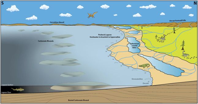
Reconstructed view to the west across Purbeck lagoon with land (and footwall hills) to north and lagoon deepening to the south. Carbonate mounds accumulated in a depth-restricted zone within the lagoon (corresponding to study area) adjacent to shoreline beaches, bars and lakes as represented by the Durlston Bay section to the north (modified from Sellwood and Wilson, 1990, hybodontiform fish after Stumpf et al., 2021).

Cover of the scientific journal Proceedings of the Geologists' Association (PGA).
In Volume 136, Issue 4 (August 2025) of Proceedings of the Geologists' Association.
Read the full article here (Open Access): www.sciencedirect.com/science/arti...
29.07.2025 14:43 — 👍 0 🔁 0 💬 1 📌 0
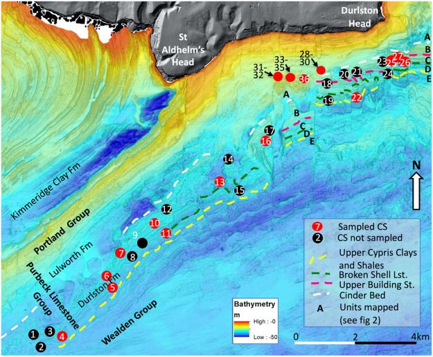
Multibeam Echo Sounding (MBES) of sea floor (colour bathymetric scale) and digital elevation onshore (grey scale) images of study area. Circular structures (CSs) are numbered as per Table 1 and those dived and sampled coloured red. Prominent ledges mapped on this seafloor MBES image are marked with dashed coloured lines and define informal units A–D in the Purbeck Limestone Group. Note the circular structures are mainly restricted to the Durlston Formation and are not recognised to the west of structures 1 and 2, or to the east of structure 26. (After Boscence et al., 2018).
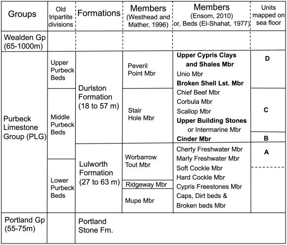
Lithostratigraphic divisions of Purbeck Limestone Group (after El-Shahat, 1977; Westhead and Mather, 1996 and Ensom, 2010) with those members in bold as mapped as prominent ledges on the sea floor.
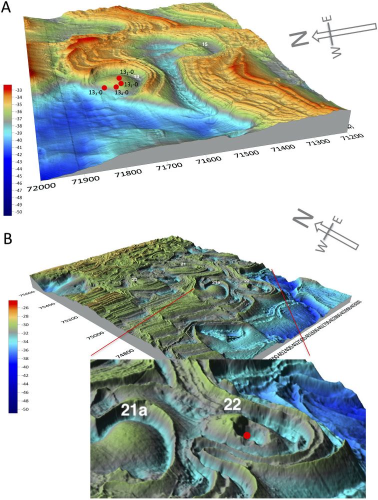
A. View towards east of CS 13 illustrating exhumed, dome-shaped, circular structure truncated by fault on north-west margin. Sample locations illustrated with red dots. Scale from 100 m spaced grid (depth scale in m). B. View towards northeast of CSs 21a and 22 in southeasterly dipping strata cut by N trending faults. Single sampled location (red dot) in eroded out core of dome-shaped structure CS 22 (depth scale in m and 200 m spaced grid).
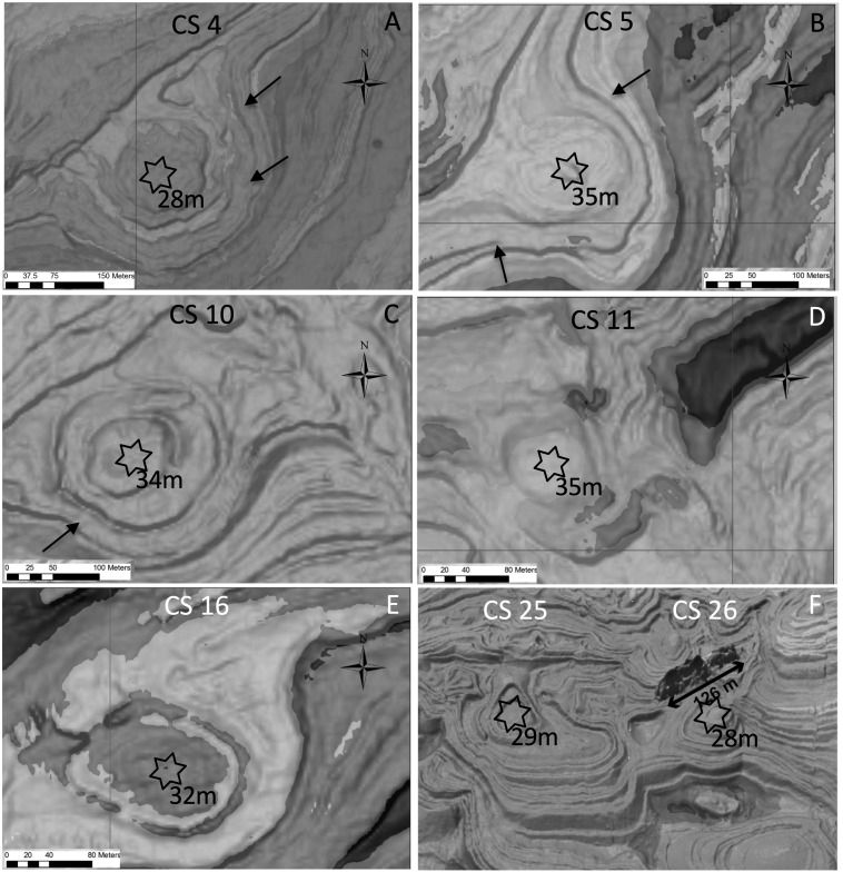
A–F. Greyscale images of selected circular structures to show location of sampling sites (location of circular structures shown in Fig. 3). Within each star samples were taken at the shot point (explained in text below) or on oriented lines radially out from shot point as detailed in Table 1. Arrows in A–C indicate apparent onlap onto crest of circular structures.
Microbial mound origin for enigmatic sea-floor circular structures? Purbeck Limestone Group, offshore Dorset by Dan Bosenceᵃ, Jenny Collierᵇ, Arnaud Galloisᵃ, Ian Watkinsonᵃ, Chris Dunkerley, Simon Flecknerᵃ
ᵃ @royalholloway.bsky.social
ᵇ @eseimperial.bsky.social @imperialcollegeldn.bsky.social
29.07.2025 14:43 — 👍 3 🔁 0 💬 1 📌 0

The cover image of the scientific journal Proceedings of the Geologists' Association.
In volume 136, Issue 4 (August 2025) of Proceedings of the Geologists' Association (PGA)
Read the full article online (open access): www.sciencedirect.com/science/arti...
22.07.2025 16:39 — 👍 0 🔁 0 💬 0 📌 0
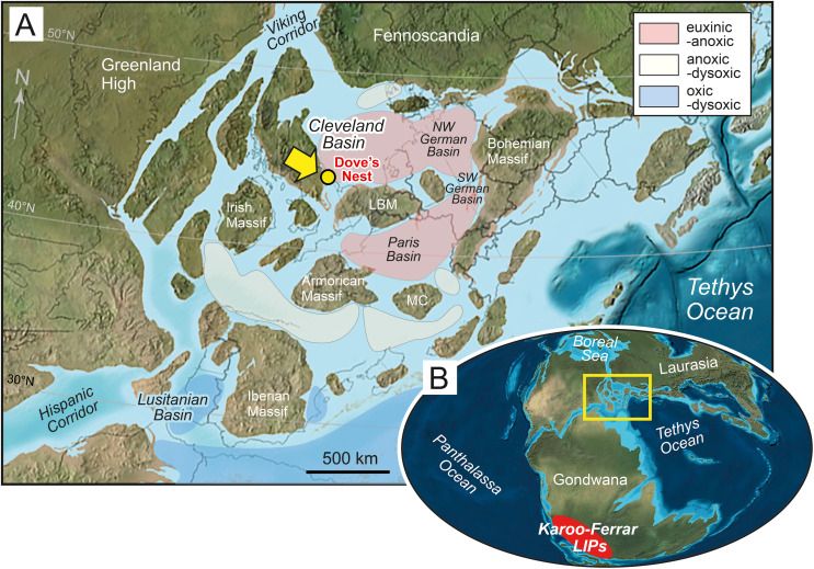
Early Jurassic palaeogeography, regional setting, and location of the Dove's Nest study core in the Cleveland Basin. (A) Palaeogeographical reconstruction of Europe showing location of the basin on the European epicontinental shelf; interpreted bottom-water redox conditions associated with the T-OAE are based on geological data and ocean circulation modelling (Ruvalcaba Baroni et al., 2018). Palaeolatitude based on the online palaeolatitude calculator of van Hinsbergen et al. (2015) at 183 Ma (https://paleolatitude.org) with the palaeomagnetic reference frame of Vaes et al. (2023). (B) Global palaeogeography of the Early Jurassic showing continent configuration, major ocean basins, and location of the Karoo–Ferrar Large Igneous Provinces (LIPs) that was emplaced during the early–middle Toarcian (Heimdal et al., 2021; Gaynor et al., 2022). Yellow box shows location of Europe map.
Palaeogeographical base maps modified from Blakey, 2012, Blakey, 2016.
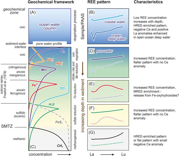
Schematic PAAS-normalised REE patterns of seawater and representative pore waters. (A, C) Data are plotted in a geochemical framework of increasing depth in sediment underlying an oxic water column. (B) Negative cerium anomalies characteristic of deep open-ocean water are generally lacking in (D–G) marine pore waters. Pore-water REE patterns (e.g., D, F) are typically flatter than those of seawater with MREE enrichment evident in (E) the anoxic ferruginous zone. (G) HREE enrichment may occur under methanic conditions. The thicknesses of the oxic and anoxic manganous zones range from mm to cm in organic-rich shelf and upper slope sediments, to m in organic-lean deep-water pelagic settings. REE patterns compiled from Haley et al. (2004), Kim et al. (2012) and Chen et al. (2015). Geochemical framework (C) adapted after Canfield and Thamdrup (2009). SMTZ is the sulfate (SO4)–methane (CH4) transition zone.
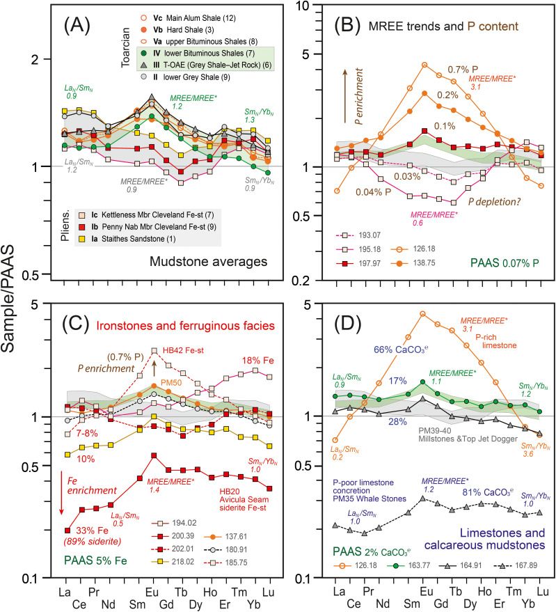
Comparison of PAAS-normalised REE patterns for main lithologies sampled in the Dove's Nest core. (A) Mudstone averages for individual chemostratigraphical units. Data filtered to remove low-aluminosilicate (< 10 % Al; sandstones, ironstones, limestones) and high phosphate (≥ 0.10 %) samples prior to calculation of average shale values (number of samples in parentheses). Coloured bands show the fields of average values for Subunits Ia–Ic (grey) and Units III and IV (green). Average values for Unit V also fall within the green-shaded interval. (B) Relationship between percentage P content (brown) and MREE patterns of selected samples (see Fig. 8, Fig. 10B). (C) Ironstones and ferruginous facies (see Fig. 5, Fig. 6). Percentage Fe contents (red) and bed numbers (HB20, PM50, HB43) of selected samples are indicated. Note the impact of P content on the MREE pattern (HB43 = 0.3 % P; PM50 0.1 % P; 218.02 0.05 % P). (D) Limestones and calcareous mudstones. Percentage CaCO3℮ values in blue (see Fig. 5). Note the expanded y-scale in A compared to B–D. Shading emphasises the contrasting REE patterns of oxic Pliensbachian Subunits Ia–c (pale grey) to anoxic–euxinic lower Toarcian Units III and IV (pale green). Bed numbers (PM = Port Mulgrave; HB = Hawsker Bottoms) and names of coast marker beds are indicated where appropriate (Table S1). Values in figure keys are sample numbers ( = m below core top). Symbol styles correspond to placement of samples within chemostratigraphical units (see D and Table S1).
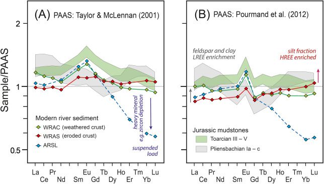
REE patterns of modern average river sediments compared to Dove's Nest Jurassic mudstones. (A) Data normalised to the PAAS values of Taylor and McLennan, 1985, Taylor and McLennan, 2001, ‘average mud’). (B) Data normalised to the PAAS values of Pourmand et al. (2012). World River Average Clay (WRAC) and World River Average Silt (WRAS) after Bayon et al. (2015); Average River Suspended Load (ARSL) from Goldstein and Jacobsen (1988). Jurassic mudstone averages as in Figure 12A. Note the absence of positive MREE anomalies and increased positive Eu anomalies in the Pourmand et al. (2012) PAAS-normalised patterns. Eu anomalies were considered by Bayon et al. (2015) to be artefacts of anomalous low Eu values in average shale compilations.
Do REEs in mudstones record bottom-water redox?: The Pliensbachian–Toarcian record (L. Jurassic) & T-OAE in the Cleveland Basin, England by Ian Jarvisᵃ Elizabeth Atarᵇᶜ Darren R Gröckeᵇᶜ João P Trabucho-Alexandreᶜ
ᵃ@kingstonuniversity.bsky.social
ᵇᶜ@durhamearthsci.bsky.social
ᶜ@uugeo.bsky.social
22.07.2025 16:39 — 👍 1 🔁 0 💬 1 📌 0
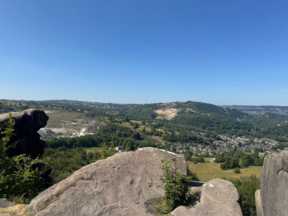
The view from Black Rocks across to the Derwent Gorge at Matlock.
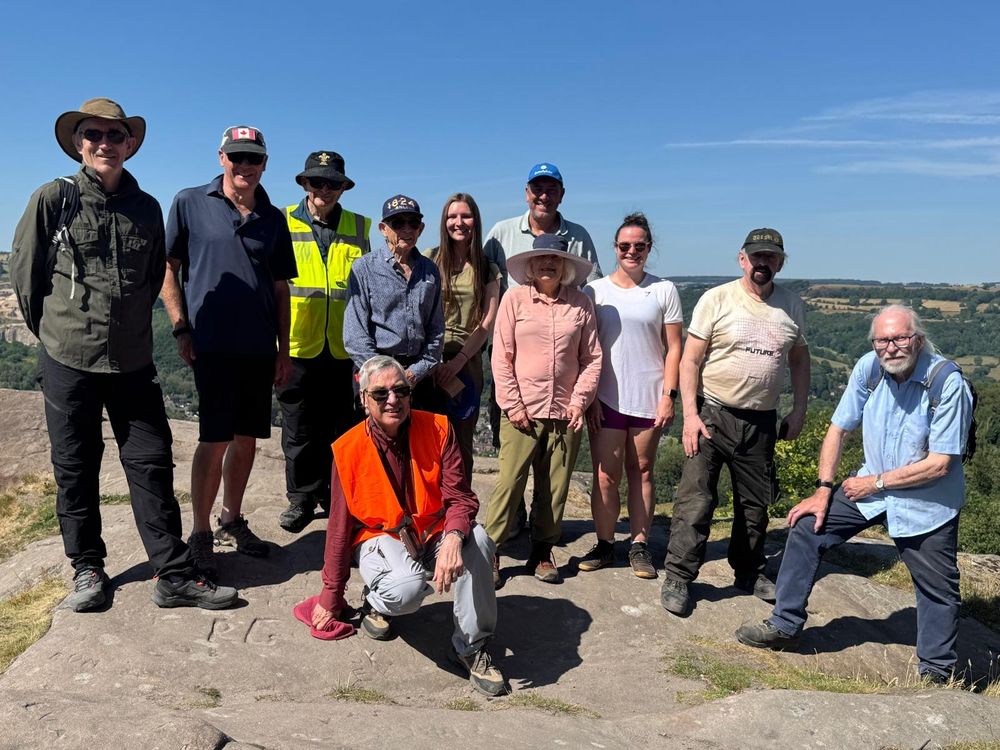
The obligatory group photo at the Black Rocks viewpoint at the end of a very enjoyable day exploring Derbyshire geology in the glorious sunshine.
Tomorrow we will be continuing the Carboniferous story looking at the limestone, karst hydrology & mining legacy around Over Haddon with Vanessa Banks
Photo credit: Cathy Gallagher
12.07.2025 19:51 — 👍 3 🔁 0 💬 0 📌 0
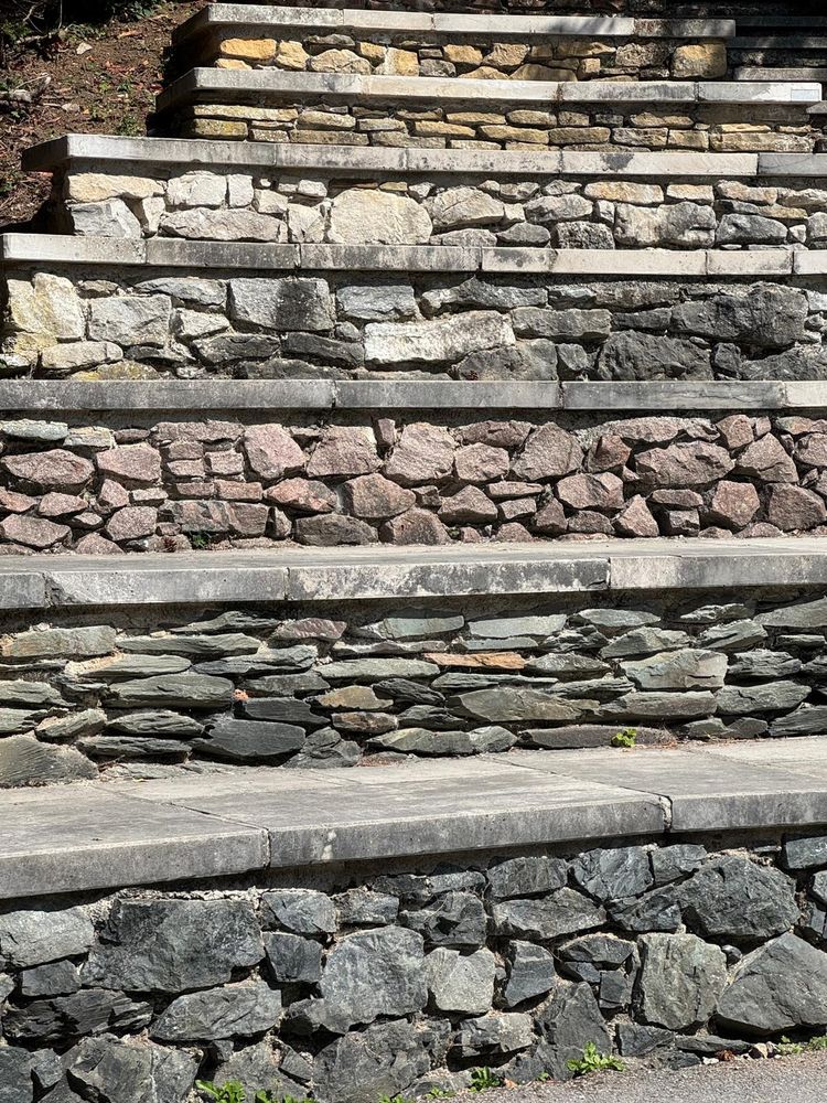
The Geosteps at the National Stone Centre. A special auditorium and performance arena - the ten risers represent the transition of rock ages in ascending order.
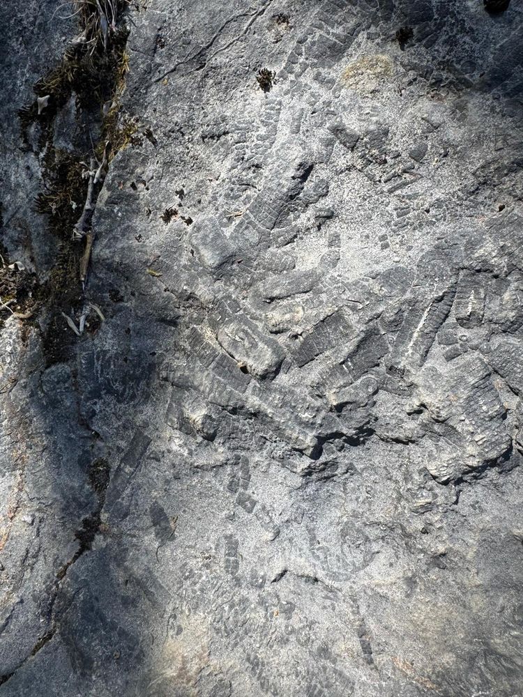
The Eyam Limestone Formation in a disused quarry at the National Stone Centre. This crinoid-rich limestone was laid down in the Lower Carboniferous period when the Peak District was the bed of a sub-tropical shallow continental shelf sea.
National Stone Centre logo.
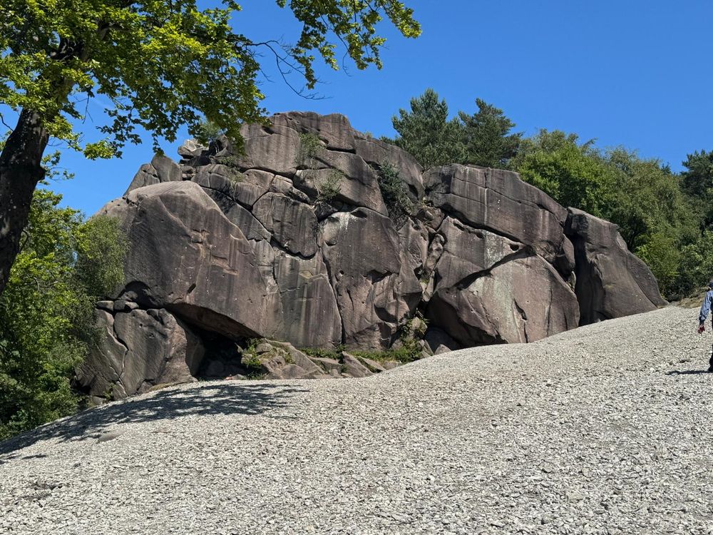
Black Rocks: a small outcrop of Ashover Gritstone (a coarse Carboniferous sandstone).
Thank you to Peter Jones for leading our very informative trip to Derbyshire today to examine the geology of the Wirksworth and Cromford areas
Starting and ending the day at the The National Stone Centre we focused on rocks of the Carboniferous period among the wider Quaternary landscape
12.07.2025 19:51 — 👍 3 🔁 0 💬 1 📌 0
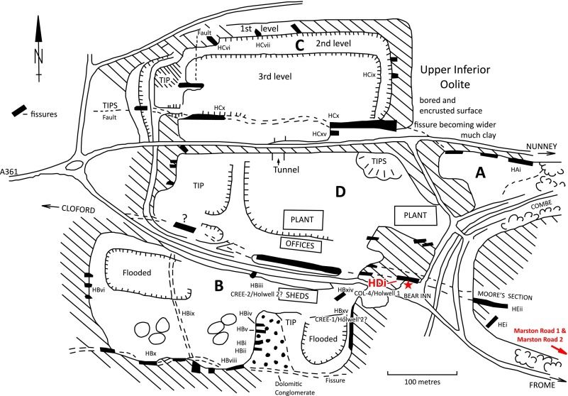
Map of the Holwell Quarries of the quarries in April 1977 showing the positions of all the major fissures. A) Lime Kiln Quarry, B) Cree's Quarry, C) North Quarry and D) Coleman's Quarry. Redrawn from Copp (1980; fig. 69). Each fissure is labelled according to the locality, quarry and incremental numbering of the fissures (e.g., HBiv: Holwell, Cree's Quarry, fourth (iv) fissure).
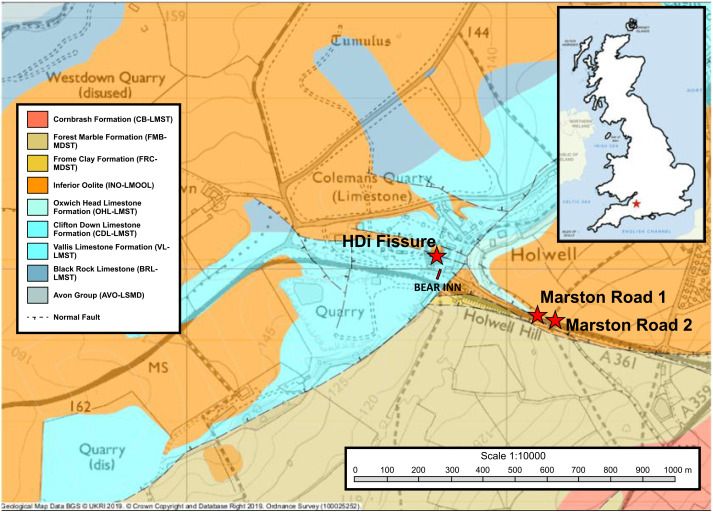
Geological map of the Holwell Quarries with the position of the HDi fissure sampled here, as well as the two nearby localities of bedded Rhaetian Marston Road 1 (Nordén et al., 2015) and Marston Road 2 (Whiteside and Duffin, 2021).
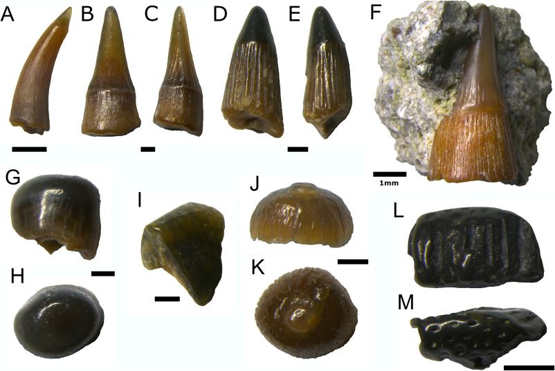
Osteichthyan teeth. (A) Gyrolepis albertii (BRSMG Cf8617.40). (B–F) Severnichthys acuminatus; (B, C) ‘Birgeria acuminatus’ type (BRSMG Cf8617.116), (D, E) ‘Saurichthys longidens’ type (BRSMG Cf8617.117), (F) ‘Birgeria acuminatus’ type embedded in matrix (BRSUG 29410-14). (G, H) Sargodon tomicus teeth, (G, H) molariform (BRSMG Cf8617.107) and (I) incisiform (BRSMG Cf8617.49). (J, K) “Colobodus” tooth (BRSMG Cf8617.98). (L, M) Ceratodus sp. tooth (BRSMG Cf8617.55) in lateral? (L) and occlusal (M) views. All scale bars are 0.5 mm, except where labelled otherwise.
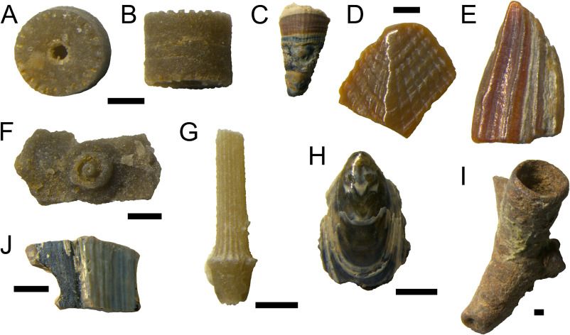
Invertebrate remains. (A, B) Crinoid ossicle (BRSMG Cf8617.121) in facet (A) and lateral (B) views. (C–E) Eolepas rhaeticus (BRSMG Cf8617.126, 124 and 127), rostrum (C), scutum (D) and ?carina (E). (F) Echinoid interambulacral plate (BRSMG Cf8617.77). (G) Echinoid spine (BRSUG 29410-37). (H) Lingula sp. (BRSMG Cf8617.123). (I) Possible micronconchid worm tube (BRSUG 29410-34). (J) Unidentified shell plate (BRSMG Cf8617.122). All scale bars are 0.5 mm.
Microvertebrates from a Rhaetian neptunian dyke at Holwell, Somerset: Dating the fissures
In volume 136, Issue 4 (August 2025) of Proceedings of the Geologists' Association. Read more here (open access): www.sciencedirect.com/science/arti...
11.07.2025 14:50 — 👍 3 🔁 0 💬 0 📌 0
There's still chance to submit up to 3 photos to the GA 2025 Photo Competition to be in with a chance of winning a cash prize!
Closing date: Friday 22 August 2025
Email your entries to: photocomp@geologistsassociation.org.uk
For full details: geologistsassociation.org.uk/photocomp_en...
09.07.2025 11:00 — 👍 1 🔁 1 💬 0 📌 0
NAGT works to improve the teaching of the Earth sciences by providing teaching resources, professional development events, and high-quality publications.
https://nagt.org/index.html
Retired cc geology prof and geology enthusiast. I remember when university science buildings were built w/o women’s restrooms. Opinions are mine. She/Her 🚫DM
San Onfre Breccia, Dana Point, CA and Sky Blue Limestone, Crestmore Quarry, Riverside, CA.
Prof of Applied Geology, U Leicester. Sustainable mineral resources for the green transition. Geology, life, Kernow 〓〓.
Views personal and do not represent my employers.
Lecturer in Forensic Geoscience | Igneous petrologist | Geochemist | Autistic | Editor @WeAreVolcanica | Editor @StudentNatural | All views my own
Hydrology Paper of the Day / Fellow of the Royal Geographical Society / Professor / Researcher / British Columbia, Canada. 🇨🇦 🇺🇦
Geologist fascinated by how rocks break, bend or flow. Director of Geosolutions Leeds since April 2024.
"Don't fight the system; replace it"
UH EAS department includes faculty, grad students, and undergraduates conducting research in geology, geophysics, and atmospheric sciences around the world.
Global Schools Manager at Esri. Supporting schools to teach with and about GIS. Working on the new National Geographic MapMaker app www.esri.com/mapmaker.
#GIS4Good #Equity #CTE #XR
He/Him/His. Views are my own
Archaeologist & Associate Professor in Palaeolithic Archaeology at UCL, where we run the PaPa MSc programme.
Researching Neanderthal archaeology in La Mancheland & Western Doggerland, from Boxgrove to La Cotte.
Provide Geoarch expertise to ASE.
He/Him 🏺
Seismologist at Ruhr University Bochum, Germany
Treasurer of the German Geophysical Society (DGG e.V.)
University of Leicester PhD student | SEIS-UK Research Assistant | Geodynamics & Seismology |
Lecturer in Earth Sciences @ the University of Derby
Geologist | Sedimentologist | Reservoir Characterisation
Kiwi volcanologist working on Ngāuruhoe (Mt Doom) in NZ, the 2021 La Palma/Tajogaite eruption impacts, seafloor geologic hazards I 'On Shaky Ground' writer
The EDIG (Equity, Diversity, and Inclusion in Geoscience) project is a volunteer-led, online initiative aiming to make geoscience more inclusive, accessible, and equitable for everyone.
Check out our new website at: https://ediingeo.org/
The Faculty of Geosciences has the ambition to be a global trailblazer in education and research with regard to our Earth system and sustainability, from the local to the global scale. https://www.uu.nl/geo
Posts in Dutch and English
Compartimos información sobre nuestras actividades docentes e investigadoras y sobre Geología. Departamento de Ciencias de la Tierra, Universidad de Zaragoza.
Zaragoza, cienciastierra.unizar.es
The 'Geological Research through Integrated Neoproterozoic Drilling' initiative aims to create a global archive of cores through 1000 – 520 Ma time interval ⚒️
The Dinosaur Society is a UK charity established to encourage an interest in dinosaurs.
http://www.dinosaursociety.com


