NOAA Coastal Ocean Reanalysis (CORA) | Offshore Maritime Vessel
Coastal Ocean Reanalysis (CORA)'s denser data resolution between tide gauges closes gaps in data coverage along the coast.
"game changer" dataset - first computer-modeled, historical water level and wave dataset for the Atlantic, Caribbean and Gulf coasts. Data from 1979 to 2022! Help improve flood-mitigation tools and flood risk assessment.
www.guiceoffshore.com/new-noaa-dat...
05.03.2025 19:57 — 👍 2 🔁 0 💬 0 📌 0

Geographers without Borders
Science Podcast · 2 Seasons · Updated Monthly
I just came across this Geographers without Borders podcast focused on empowering women's voices in geosciences - supported by @womeningis.bsky.social
podcasts.apple.com/us/podcast/g...
04.03.2025 22:07 — 👍 4 🔁 1 💬 0 📌 0
Is anyone up to test my geoparquet downloader qgis plugin? We want to change the directory in the latest release, which means migrating users from the old plugin to the 'new' one. If you could try out github.com/user-attachm... and let me know how it works I'd appreciate it.
02.03.2025 22:52 — 👍 2 🔁 2 💬 1 📌 0
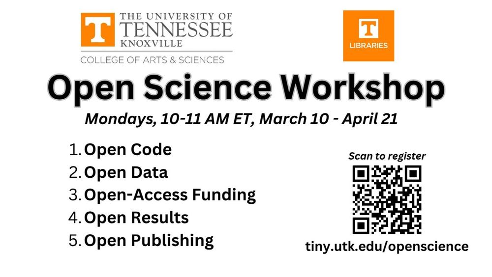
🌟 I am excited to invite you to participate in the upcoming Open Science Workshop and Symposium, sponsored by the University of Tennessee College of Arts & Sciences. This series aims to enhance awareness and engagement in open science practices across our community.
03.03.2025 18:40 — 👍 11 🔁 2 💬 1 📌 2

🚀 #GeoAI Tutorial 2: Downloading NAIP Imagery & Building Footprint Data for Deep Learning 🌍✨
🔗 Watch the tutorial: youtu.be/5qfZe_fITcM
🛠️ Explore the GitHub: github.com/opengeos/geoai
📚 Dive into the Docs: geoai.gishub.org
🎥 YouTube Playlist: bit.ly/GeoAI-Tutori...
#geospatial #ai #python
03.03.2025 17:12 — 👍 14 🔁 4 💬 0 📌 0
This is one of the most useful threads with starter packs for all things geospatial. Highly recommend :) Thanks @satellitesci.bsky.social
28.02.2025 05:11 — 👍 8 🔁 3 💬 1 📌 0
Thank you for all these AMAZING starter packs!!
28.02.2025 05:04 — 👍 1 🔁 0 💬 0 📌 0
More job resources in the geospatial industry compiled by some amazing people in this community.
www.linkedin.com/feed/update/...
28.02.2025 04:41 — 👍 0 🔁 0 💬 0 📌 0
Fantastic collaboration opportunity with some of the best in geospatial and AI. Check out the full post.
26.02.2025 15:03 — 👍 1 🔁 0 💬 0 📌 0
Many people are currently looking for a job - this geospatial hub and the @geospatialwomen.bsky.social career updates are all great places to stay on top of geospatial opportunities.
26.02.2025 03:43 — 👍 0 🔁 0 💬 0 📌 0
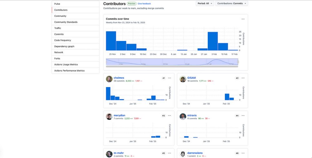
New Features of GeoParquet Downloader QGIS Plugin
Many new improvements have landed recently, from a variety of contributors, turning this plug-in to a true open source project
Just published a post on new features in the GeoParquet Downloader QGIS Plug-in I've been working on, see cholmes.medium.com/new-features...
The most exciting thing to me is that a majority of the new enhancements have come from outside contributors.
20.02.2025 23:57 — 👍 7 🔁 3 💬 2 📌 0

London Data Visualisation February - Blender Workshop · Luma
If you feel inspired by the visual journalism of the New York Times, winners of the Information is Beautiful awards or the wonderfully crafted graphics of…
Excited to announce my hands-on & in person workshop: "Introduction to 3D maps and data visualisation with Blender". You will learn how to create memorable 3D visualisations that stand out. #dataviz
Register here: lu.ma/gtg2elht
11.02.2025 17:07 — 👍 18 🔁 6 💬 1 📌 0
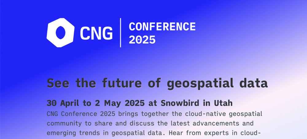
You, yes you, can help the Cloud Native Geospatial Movement!
Have you benefitted from COG’s, STAC, Zarr, COPC or GeoParquet? Join us in Utah for the first CNG Conference and help just by attending.
You, yes you, can help the Cloud Native Geospatial Movement!
Have you benefitted from Cloud-Optimized GeoTIFF’s? SpatioTemporal Asset Catalogs? Zarr, COPC or GeoParquet? And the ecosystem around them?
Learn how to give back in my post: cholmes.medium.com/you-yes-you-...
10.02.2025 22:00 — 👍 7 🔁 4 💬 1 📌 0
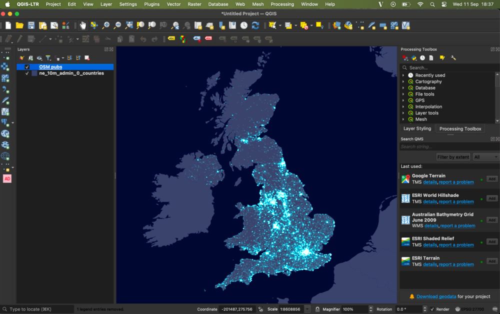
How to make a firefly map with QGIS
Follow this quick and easy guide to create stunning firefly maps with QGIS! 🌟
After making a massive $7.19 in 4 months (less than the $10 payout threshold), I've decided to start ungating my Medium-hosted tutorials (it's not really in the knowledge-sharing spirit anyway!) and migrate them to my website, starting with... www.helenmakesmaps.com/post/how-to-... 🎆🗺️
17.01.2025 11:10 — 👍 62 🔁 12 💬 1 📌 0

JEO 1 - 2024 Year in Review
Welcome to the first edition of Japan Earth Observer (JEO)
Not sure if Robert Cheetham is on here yet, but I just read his newsletter about the Japan EO market and loved it! Check out the list of Geo/EO events in that area of the world
www.japanearthobserver.com/japan-earth-...
09.02.2025 20:44 — 👍 1 🔁 1 💬 0 📌 0
Thank you 🤗
01.02.2025 01:49 — 👍 0 🔁 0 💬 0 📌 0
I'd love to be included! @thenadinesa.bsky.social
31.01.2025 04:10 — 👍 0 🔁 0 💬 1 📌 0
NSPIRES - Solicitations Summary
NASA and U.S. Government policies address research and personal misconduct, and provide avenues for reporting potential violations.
If you're a U.S.-based researcher interested in getting free access to GHGSAT methane emissions data, submit a proposal to NASA's Commercial Satellite Data Earth Science Research and Applications (CESRA) call! (1/2)
Step-1 proposals are due Feb 14, Step-2 due Apr 9.
More info: bit.ly/40D28SP
30.01.2025 21:45 — 👍 13 🔁 4 💬 1 📌 0

🚀 Just dropped a new tutorial: How to use Open WebUI with Deepseek R1 without Internet access - A truly local AI 🖥️
🎥 Watch now: youtu.be/wdHRud-e9vY
🔗 Deepseek playlist: bit.ly/deepseek-tut...
#AI #DeepseekR1 #LocalAI #Ollama
31.01.2025 02:55 — 👍 19 🔁 4 💬 0 📌 0
Earth Observation consultant in the UK, but strong links to EU and Copernicus for land monitoring. Director and consultant at Specto Natura (http://www.specto-natura.co.uk/).
Data Visualization. Ex-Planet & NASA Earth Observatory. Blue Marble, Earth at Night, color, cartography, occasionally skewed views of Earth. Looking for a job.
The #CopernicusClimate Change Service (#C3S) & #CopernicusAtmosphere Monitoring Service (CAMS), implemented by @ecmwf.int on behalf of the @ec.europa.eu.
🚀 Accelerating and 🌲 scaling impactful projects with great software and design. Woman-owned.
Moderating the Global Ecology feed 🌐
https://bsky.app/profile/nmouquet.bsky.social/feed/global.ecology
- DM to contribute to the feed
- DM to join the Global Ecology starter packs https://go.bsky.app/F86HYqj
- Crafted with 💚 by @nmouquet.bsky.social
Researcher at the Department of Geoscience, University of Oslo. I'm a climate scientist focusing on Bayesian data assimilation, remote sensing, and the cryosphere (snow, glaciers, and permafrost).
Remote sensing of our living environment from space-borne to UAS/UAV, from the tropics to the Arctic -- at @uni-wuerzburg.de, Germany -- https://www.remote-sensing.org http://www.earth-observation.org - managed by Dr Martin Wegmann
Professor at Virginia Tech, Lead, Land Subsidence Analytics at United Nations University, US Rep. to UNESCO LASII
Web: EOIvt.com
Sharing satellite images & astronaut photos of our incredible planet and explaining the amazing science behind them! 🛰️📸
Data visualisation designer at BBC News focusing on satellite data, climate change and cartography | previously at @esa.int | Co-founder of @chartle.cc - A daily chart game
Postdoc @ Rutgers University 📍NJ
🌲🛰️🌎 Ecologist by day: remote sensing, biodiversity, ecosystem structure, geospatial Rstats + GIS
🥾🎨🥏 Mudpuppy by moonlight: outdoor educator/explorer, science illustrator, pun enthusiast, frisbee player/coach (she/her)
Geospatial Data Scientist 🌏🛰️
Pesquisador em Geoinformatica, Ciência de Dados Geoespaciais, Modelagem de Uso da Terra. Foi diretor do INPE (2005-2012) e do Group on Earth Observations (2018-2021). Gosta de Milton, Miles Davis, John Coltrane, Ockeghem, Monteverdi e Luciano Berio
Cartographer | Anti-imperialist | prev w/ Nat Geo | Free Palestine 🇵🇸
Climate change, oceans, blue carbon and coastal communities. Professor, researcher, educator, author. 🌊
📕: At Every Depth @ateverydepth.bsky.social
AtEveryDepth.com
bio.site/Tessahill
Monitoring the environment with satellites, drones, and other remote sensors at the gov.
Interested in biodiversity & climate policy and conservation action. Based in the highly urbanized region of Flanders, Belgium
#remotesensing #earthobservation
Full-time cartographer, part-time menace.
🇨🇺Se habla espanglish
Gender and Social Inclusion Informed Geospatial Solutions for Development
Marine Geologist w/USGS; likes to nerd out about marine geohazards, paleoclimate and seascape evolution; lover of dogs, soccer et al.
Explorer of oceans, crafter of nifty things, mother of rascals, avoider of COVID
@oceandiscleague.bsky.social Founder & President
@NatGeo Explorer
@aaas.org Ambassador
@theexplorersclub.bsky.social EC50
Posts & opinions mine alone.