How can a “Digital Twin” help to build a more resilient agricultural future?
The #EOAgriTwin project creates virtual replicas of agricultural systems to monitor crop conditions under various stressors.
Explore the tools, use cases and methods in this video!
13.02.2026 07:56 — 👍 2 🔁 2 💬 0 📌 0

Commodity frontiers expand more slowly into tropical forests where forest smallholders are present – new paper out in PNAS led by Marie Pratzer
www.pnas.org/doi/10.1073/...
@tkuemmerle.bsky.social
@humboldtuni.bsky.social
@pnas.org
12.02.2026 16:42 — 👍 8 🔁 5 💬 1 📌 0

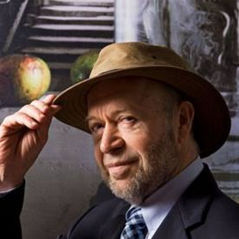
Portrait of Dr. Valerie L. Thomas, the pioneering Black NASA scientist and inventor, smiling warmly at the camera. She has shoulder-length wavy gray hair, wears thin gold-framed glasses, gold hoop earrings, and a light gray herringbone-patterned blazer over a white top with a small pin on the lapel, standing confidently against a neutral gray background.
Valerie Thomas spent 30+ years at NASA helping revolutionize how we see images from space & our own world. #WomenInSTEM
Managed the development of the first image-processing systems for the Landsat program allowing satellites to send the 1st multi-spectral pictures of Earth back to scientists.(1/2)
08.02.2026 23:07 — 👍 1380 🔁 329 💬 13 📌 7

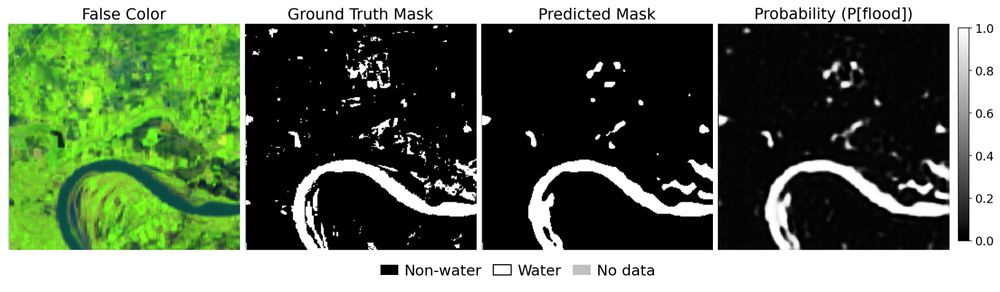
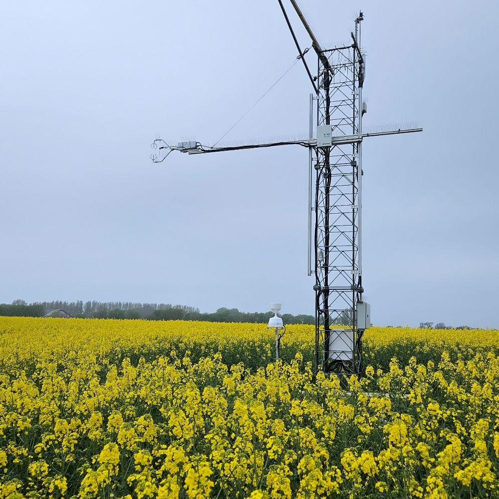
EOLab’s Florian Poetzschner is presenting current progress of Field delineation and water use assessment for EOAgriTwin - ‘A Digital Twin for Agriculture under multiple stressors’ at ESA's Open Science Meeting in Frascati
Find out more about the project:
www.eoagritwin.eu
04.02.2026 10:46 — 👍 3 🔁 1 💬 0 📌 1
In two weeks, world leaders and tech executives will descend on Delhi for the AI Impact Summit 2026. There, power brokers will paint a pretty picture of the role AI will play in saving the world - from sharing prosperity to fixing climate change.
03.02.2026 18:14 — 👍 63 🔁 31 💬 4 📌 5

Join us for the upcoming #EOAgriTwin webinar focusing on the latest progress of our #DigitalTwin Component for agriculture. We will share the current status and demonstrate key capabilities.
📅 13 January 2026, 13:00
Registration: www.eoagritwin.eu/webinar
@zalf.bsky.social
05.12.2025 11:38 — 👍 3 🔁 1 💬 0 📌 1
Thanks to an amazing network of colleagues and friends, 50% of the funding have been secured already! 🌍🌽💧
05.11.2025 08:30 — 👍 0 🔁 0 💬 0 📌 0

Donate to Protecting nature by fighting poverty in Mozambique, organized by Philippe Rufin
I am Philippe Rufin, a scientist working in the nexus of small-scal… Philippe Rufin needs your support for Protecting nature by fighting poverty in Mozambique
Following a field campaign in Gilé National Park, Mozambique, I´ve launched a crowdfunding campaign to support nature conservation by helping farmers improve their production with irrigation: www.gofundme.com/f/fight-pove...
Please help make this work and donate or share with friends & family! ❤️
26.10.2025 13:31 — 👍 2 🔁 0 💬 0 📌 1
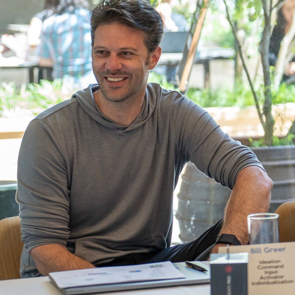
YouTube video by The Leadership Lab
Earth Observed | Episode 1: Bill Greer | How Nonprofit Satellites Could Change Everything
I was on a podcast talking about Common Space: www.youtube.com/watch?v=xQof...
I can't stand listening to myself speak, so let me know if i was any good.
21.08.2025 12:38 — 👍 2 🔁 1 💬 0 📌 0
Great to see this out - Shupel is a true role model, paving the way for female researchers from northern Nigeria!
21.07.2025 12:26 — 👍 3 🔁 0 💬 0 📌 0
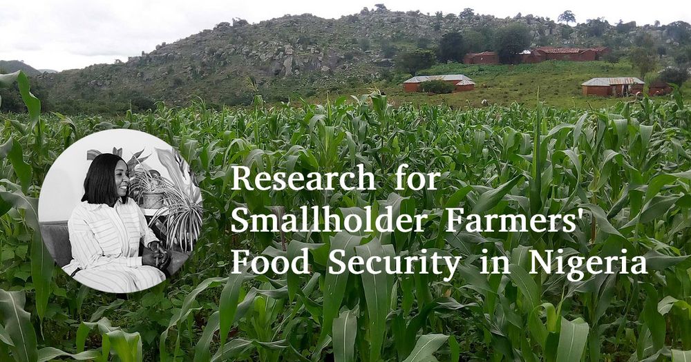
Header Image of Maize field with a picture of Esther Shupel Ibrahim and text: Research for Smallholder Farmers' Food Security in Nigeria
Using Remote Sensing and Agro-Ecosystem Modelling 🛰️🌽📈, Esther Shupel Ibrahim analyzes impacts of climate change and diseases on smallholder agriculture in Nigeria and develops strategies to support and empower smallholder farmers.
Find out more about her PhD research in this StoryMap:
arcg.is/1bG48K
21.07.2025 11:09 — 👍 7 🔁 5 💬 1 📌 1
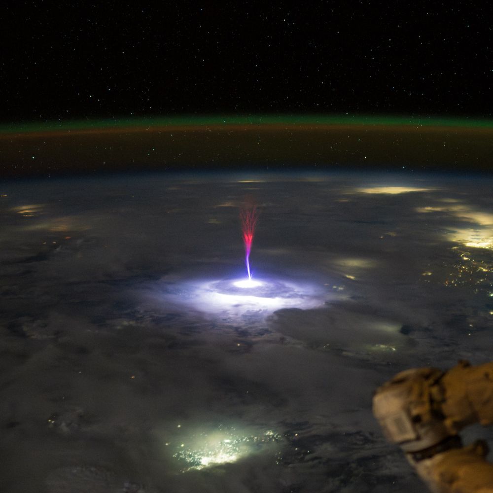
Photograph taken from the International Space Station by astronaut Nichole Ayers, capturing a rare gigantic jet — an upward lightning discharge shooting from a thunderstorm about 90-100 km high into the upper atmosphere. The jet appears as a vivid purple and blue column of light that finely branches out toward the top where it turns into a vivid red color. It's rising from a brightly illuminated cloud top, surrounded by diffuse city lights from Northern Mexico and South Texas. Behind it is the curved limb of Earth with a green band from the airglow layer indicating the edge of the atmosphere. A portion of the space station’s robotic arm is visible in the foreground.
On July 3rd, astronaut Nichole Ayers photographed a rare Gigantic jet from the ISS. These upward directed electrical discharges extend 90-100 km high into the atmosphere.
I processed this image from the RAW file, adjusting the white balance, contrast and noise reduction.
Full res: flic.kr/p/2rhxqcK
19.07.2025 11:27 — 👍 204 🔁 82 💬 3 📌 2
Fascinating ... and a hopeful sign
18.07.2025 18:10 — 👍 32 🔁 9 💬 0 📌 0
Joint effort by Pauline Hammer, Leon-Friedrich Thomas, Sá Nogueira Lisboa, Natasha Ribeiro, Almeida Sitoe, @hostertp.bsky.social & Patrick Meyfroidt! Thanks to Descartes Labs and @esa.int for providing access to SPOT6/7 data, and the F.R.S.-FNRS for funding the research!
17.07.2025 10:24 — 👍 0 🔁 0 💬 0 📌 0
Our team had the opportunity to access SPOT6/7 data (1.5 m resolution) for Mozambique! We produced ~21 million individual field delineations for 2023, which allow unique insights into the spatial distribution of agriculture, field size and the linkages between agriculture and forest cover change!
17.07.2025 10:24 — 👍 0 🔁 0 💬 1 📌 0
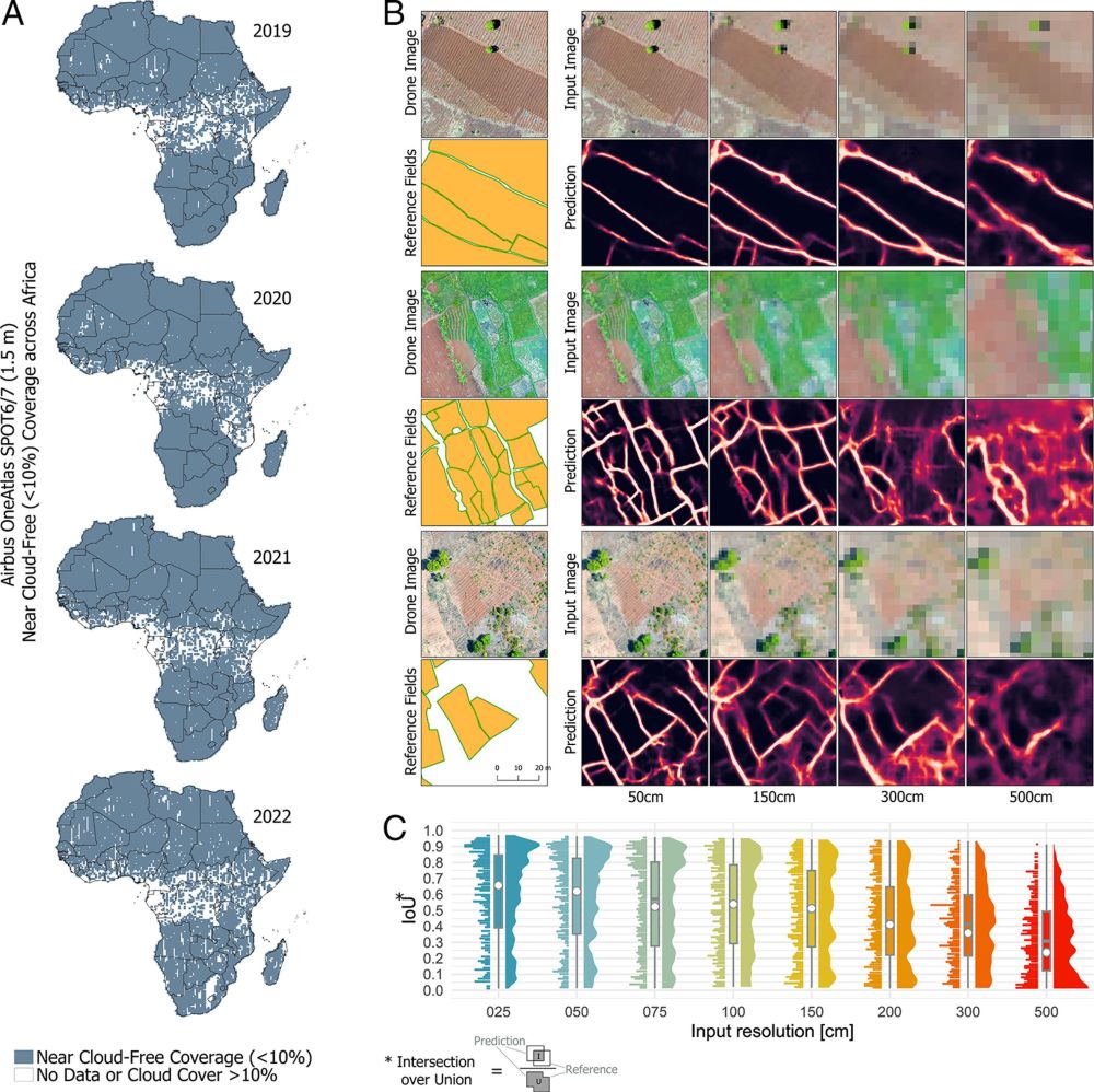
The reason behind it is oftentimes constrained access to satellite imagery at very high spatial resolution needed in these systems (also see bsky.app/profile/phil...).
17.07.2025 10:24 — 👍 0 🔁 0 💬 1 📌 0
The literature on field delineation in smallholder systems remains relatively scarce and progress is slow overall (although cudos to the colleagues working on it). Therefore we don´t have field delineations at policy-relevant scales (e.g. national) where they are most needed.
17.07.2025 10:24 — 👍 0 🔁 0 💬 1 📌 0
Smallholder-dominated landscapes are entirely different from the mechanized and consolidated landscapes (which are oftentimes considered for benchmarking AI models).
17.07.2025 10:24 — 👍 0 🔁 0 💬 1 📌 0

Drone capture from Mozambique illustrating the landscape complexity in smallholder landscapes.
Despite free access to petabytes of satellite data, cloud computing platforms, and a wealth of high-performing computer vision models, satellite-based field delineation simply doesn´t work in landscapes dominated by smallholders (fragmented, heterogeneous, and dynamic)!
17.07.2025 10:24 — 👍 0 🔁 0 💬 1 📌 0
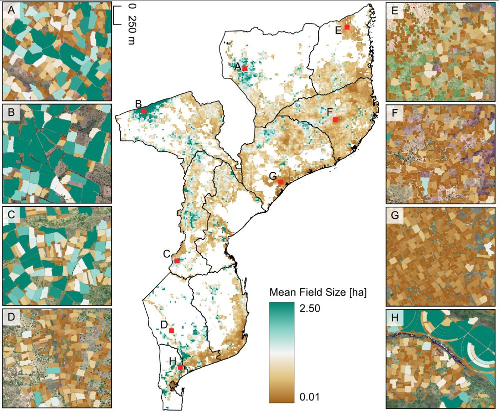
National-scale map of mean field size across Mozambique. Selected zoom ins provide details on individual fields.
🌍 🛰️ 🌱 🌽👨🏿🌾🛖💻⚙️
Preprint on national-scale satellite-based crop field delineation in smallholder landscapes is out:
doi.org/10.48550/arX...
🌍 🛰️ 🌱 🌽👨🏿🌾🛖💻⚙️
17.07.2025 10:24 — 👍 13 🔁 3 💬 1 📌 0
We have decided to ban the use of GenAI for research, writing & creative work at our organization.
In fact, we make people sign an agreement saying that their research, analysis, writing, and creative work are *theirs* and not done by GenAI.
17.07.2025 01:04 — 👍 1982 🔁 372 💬 37 📌 45
Peer review meltdown in one diagram.
Greater emphasis on glamour journals leads people to try their luck with mediocre papers. This drains the review pool (they often have to be re-reviewed elsewhere). That drops the accuracy of peer review, creating more incentive to submit mediocre papers…
16.07.2025 18:11 — 👍 108 🔁 28 💬 6 📌 0
The data cover 19 EU countries with up to 17 years of annual data. It includes detailed crop codes, farm identifiers, and organic cultivation status—crucial for analysing land-use changes and farming practices
30.06.2025 08:35 — 👍 4 🔁 3 💬 0 📌 1
Field and farm-level data on agricultural land use for the European Union - Scientific Data
Scientific Data - Field and farm-level data on agricultural land use for the European Union
A comprehensive field- and farm-level land-use dataset from the Integrated Administration and Control System (IACS) is now available: doi.org/10.1038/s415... #OpenData #EUAgri #LandUse #SustainableFarming
30.06.2025 08:35 — 👍 4 🔁 2 💬 0 📌 1
To enhance sustainable development goal research, open up commercial satellite image archives | PNAS
To enhance sustainable development goal research, open up commercial satellite image
archives
#LPS25 was a fantastic experience but let´s take a step back and reflect on the potential (and the role) of commercial EO data providers in contributing to pressing #sustainability challenges. Here´s a short recap of arguments from the scientific community: doi.org/10.1073/pnas...
30.06.2025 11:34 — 👍 7 🔁 2 💬 0 📌 0
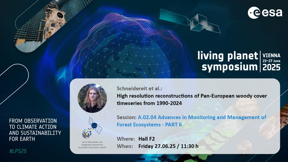
Announcement for upcoming Earth Observation Lab contribution at living planet symposium 2025:
Schneidereit et al.: High resolution reconstructions of Pan-European woody cover timeseries from 1990-2024
Session: A.02.04 Advances in Monitoring and Management of
Forest Ecosystems - PART 6
Where: Hall F2
When: Friday 27.06.25 / 11:30 h
#LPS25 wildE presentation on High resolution reconstructions of Pan-European woody cover timeseries from 1990-2024 by Shawn Schneidereit upcoming in Hall F2 at 11:30h!
27.06.2025 08:36 — 👍 4 🔁 2 💬 0 📌 0
data, policy | impact entrepreneur | covering soil and landscape‑scale agrobiodiversity
co-founder of data network https://hinterland.systems/
registering an 🇪🇺 data altruism organisation for land use data
Director of Climate Science, Awareness and Solutions at Columbia University http://csas.earth.columbia.edu | Formerly Director of NASA GISS | jimehansen.substack.com
columbia.edu/~jeh1/
SÖF-Nachwuchsgruppe am UFZ Leipzig | Forschung über #Zielkonflikte #Multifunktionalität #Agrarlandschaften | https://www.ufz.de/agriscape
Researcher @UFZ @IAMO @Humboldt University of Berlin
https://www.ufz.de/index.php?en=51503
https://www.iamo.de/en/institute/staff/details/pena-guerrero
Professor (full) in GISciences @Dynafor_Lab (INP-AgroToulouse / INRAE).
#RemoteSensing, #Biodiversity, #Forest, Landscape Ecology, #AI4EO, Complex Systems 🛰️ 🌳 ⛰️ - https://dsheeren.github.io/
Activities and latest publications of researchers at the Department of Geography @unibonn.bsky.social
Research profile and focuses: http://bit.ly/2JtH4JU
M.Sc. Graduate, KNT University
Remote Sensing | Photogrammetry
---→ Environmental Monitoring, Forest Ecology, Wildfire, UAV Photogrammetry, Bundle Adjustment, Canopy Cover
#RemoteSensing #Photogrammetry #UAV #Drone #DeepLearning #GIS
Heisenberg Professor for Nighttime Light Remote Sensing at the Institute of Geography of the Ruhr University Bochum
#RemoteSensing #CitizenScience #LightPollution
🌉 bridged from ⁂ https://fediscience.org/@skyglowberlin, follow @ap.brid.gy to interact
PhD in Political Science and International Affairs at UGA. Causal inference, political economy, GIS, and environment. https://soyergabriel.github.io/
Researcher @ Humboldt-Universität zu Berlin | Conservation Planning | Spatial Data Science | Geoinformatics
https://pages.cms.hu-berlin.de/biogeo/website/author/eduardo-lacerda/
A career network featuring science jobs in academia and industry.
Visit our platform at www.science.hr
research on atmosphere-ecosystem interactions, environment + climate | outdoor enthusiast, climber, freeheeler, born at 344ppm CO2, also posting at @lufluxes.bsky.social and @hyltemossa.bsky.social
Investigating biosphere-atmosphere exchange of greenhouse gases & energy across various ecosystems @lund-university.bsky.social
Part of @icos-ri.eu via @hyltemossa.bsky.social #Norrunda @icossweden.bsky.social
✒️ Patrik Vestin & tobiasbiermann.bsky.social
Building a dedicated satellite for humanitarian aid and disaster planning, mitigation, response, and recovery. Open data, GIS, Remote Sensing, and creating the best possible future.
Building a dedicated humanitarian satellite constellation. High resolution imagery available under an open licenses to build capacity for the humanitarian community.
Offizieller Kanal des UBA. Als Deutschlands zentrale Umweltbehörde kümmern wir uns darum, dass es in Deutschland eine gesunde Umwelt gibt, in der Menschen so weit wie möglich vor schädlichen Umwelteinwirkungen geschützt leben können. 🌱
Researcher at Dep. of Animal Ecology & Tropical Biology, Würzburg University | Biodiversity, elevational gradients, thermal limits, climate change, caves
🪲🐆🌳🏔️🔥❄️
Adventure seeker & mountain lover
https://kimleaholzmann.wordpress.com
Agriculture and Food Business Management Group at the University of Göttingen & Faculty of Agricultural Sciences
Website: https://www.uni-goettingen.de/de/655593.html