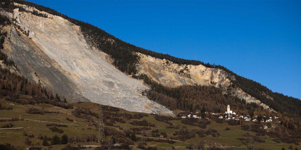
Interested in large-scale #landslides, long-term #monitoring, cool morphologies and web platforms?
Check our new article on #JMS stemming from the Solomon #EU #EFRE-FESR project
rdcu.be/d5ZRu
#CNR #UniMoRe #PAB #SouthTyrol

@georiskirpi.bsky.social
Interested in large-scale #landslides, long-term #monitoring, cool morphologies and web platforms?
Check our new article on #JMS stemming from the Solomon #EU #EFRE-FESR project
rdcu.be/d5ZRu
#CNR #UniMoRe #PAB #SouthTyrol
Last days for abstract submission!
11.01.2025 12:38 — 👍 0 🔁 0 💬 0 📌 0
Working on "Geo-Sensing and Data Science"? Wrap up your manuscript and send it to this special issue in the Journal of Rock Mechanics and Geotechnical Engineering
#monitoring #fos #landslides #geotechnics #natural_hazard #AI #Digital_Twin
Brienz has just been evacuated for the second time. The decision is based, among other things, on thousands of simulations that ETH professor Jordan Aaron has produced using a computer model he developed. In an interview with ETH News, he explains why this model was used.
13.12.2024 10:21 — 👍 24 🔁 8 💬 0 📌 1


Crisp day of #monitoring #landslides along the Tagliamento River Valley. #UAV #GNSS #SHM #Tunnel #VeryCold
09.12.2024 21:04 — 👍 1 🔁 1 💬 0 📌 0


Long-term monitoring takes a lot of patience, here in #Malta we are following the displacements of #coastal #landslides since 2005. However, if the #landscape is beautiful as such, taking some time for an accurate #GNSS survey is not so bad.
03.12.2024 16:25 — 👍 8 🔁 2 💬 0 📌 0
Great day for lidar surveys on small alpine catchments - just before the first fall of snow
21.11.2024 07:29 — 👍 1 🔁 1 💬 0 📌 0
Working on #natural_hazard affecting Long Linear #Infrastructures ( #monitoring #risk)? There is a call for abstract for you! session NH9.11 #EGU "Resilient Management of Long Linear Infrastructures in a Changing Climate" meetingorganizer.copernicus.org/EGU25/sessio... @eurogeosciences.bsky.social
20.11.2024 13:37 — 👍 0 🔁 1 💬 0 📌 1That was huge!
19.11.2024 13:47 — 👍 0 🔁 0 💬 0 📌 0Hi Luca, if you send me a DM I can give you the contacts of the PI of the project and more info
18.11.2024 15:34 — 👍 1 🔁 0 💬 0 📌 0We describe the problem and then chronicle how evidence-based decisions were made to handle it. We think that sharing the lesson in the risk management of a potential geo-disaster in a new narrative form is relevant to the scientific community facing similar issues.
31.10.2024 15:05 — 👍 0 🔁 0 💬 0 📌 0
Based on DEM of difference maps, new insight into the behaviour of the #catchment emerged - A photo of the present - assessing #sediment dynamics, how much material could be stored in the channel and the expected damage to the built environment should another event occur
31.10.2024 15:05 — 👍 0 🔁 0 💬 1 📌 0

Starting in 1789 "This paper tells a story [...] large-scale active #landslides with relevant associated risk are like “chronic patients”. The description of past events and the history of how the risk was managed are crucial elements representing their “medical records”
31.10.2024 15:05 — 👍 0 🔁 0 💬 1 📌 0

"Our job is to be prepared to the best of our knowledge and provide insight to narrowing the landscape of the possible outcomes to a likelihood of different futures"
New paper! https://rdcu.be/dYDPE on forward modelling, EWS and #landslide #risk #mitigation


Matteo Mantovani @CNR_IRPI @Georisk_IRPI as an invited speaker in #Malta, discussing about #coastal #landslides and long-term #monitoring
24.10.2024 10:36 — 👍 0 🔁 0 💬 0 📌 0
"There is no one recipe-fits-all solution for #monitoring #landslides" but if you want to know the basics (and the general philosophy) of it check out this new chapter https://www.sciencedirect.com/science/article/pii/B9780443132155000073
16.10.2024 08:37 — 👍 1 🔁 1 💬 0 📌 0Key findings include:
- Significant influence of cliff height on erosion rates.
- Use of UAV and geomechanical surveys to analyze morphological characteristics.
- Application of Random Forest and eXtreme Gradient Boosting algorithms for precise erosion prediction.
#Cliff
19.07.2024 13:22 — 👍 0 🔁 0 💬 1 📌 0
Paper Alert
We're excited to announce the release of our latest paper: "Detection of Cliff Top Erosion Drivers through Machine Learning Algorithms beween Portonovo and Trave Cliffs (Ancona, Italy)"
https://doi.org/10.3390/rs16142604
#CoastalErosion #MachineLearning #RemoteSensing...


Large event in the #Dolomites. Mass flow endangering 56 homes. Response units working non-stop to remove the #sediment
19.06.2024 08:17 — 👍 0 🔁 0 💬 1 📌 0


Two days of sharing science and brainstorming with stakeholders at the @gitonline conference. @Georisk_IRPI presenting and chairing the "Monitoring and Modelling for risk mitigation in the era of multi-temporal data" session
18.06.2024 16:08 — 👍 0 🔁 0 💬 0 📌 0


Matteo Mantovani @Georisk_IRPI today presented at #EGU2024 "An effective method to detect and measure earthflow displacements using a hybrid interferometric approach" to enhance spatial sampling of #sentinel1 derived data and monitor #landslides moving up to tens of cm/year
16.04.2024 19:46 — 👍 0 🔁 0 💬 0 📌 0By introducing the concreteness of uncertainty, the design of countermeasure works for landslide risk mitigation becomes an iterative process with explicit levels of reliability associated with their economic and environmental impacts, crucial to inform #decision makers. (5/5)
26.03.2024 16:13 — 👍 0 🔁 0 💬 0 📌 0Instead, it fosters a continuous cycle of improvement and adaptation, reflecting the dynamic interactions between #landscape, #hazard, and human interventions. Following this approach, #uncertainty becomes an opportunity rather than a weakness. (4/5)
26.03.2024 16:13 — 👍 0 🔁 0 💬 1 📌 0The iterative nature of the 3M approach allows for a more immediate and flexible response to #landslide hazards, moving away from the traditional linear pathway of assessment, design, and implementation. (3/5)
26.03.2024 16:13 — 👍 0 🔁 0 💬 1 📌 0
It incorporates over 20 years of site investigations and monitoring to continuously update the engineering geological model. Additionally monitoring provides data on the effectiveness of implemented structural mitigation measures and on how to improve their performance (2/5)
26.03.2024 16:13 — 👍 0 🔁 0 💬 1 📌 0
New paper! Investigation and Monitoring for Ever-Updating Engineering Geological Models: The Example of the Passo della Morte #Landslide System - we applied the 3M approach (#Monitoring, #Modelling and #Mitigation) in the proper recursive way...
26.03.2024 16:13 — 👍 0 🔁 0 💬 1 📌 0


Coupling photogrammetric and bathymetric surveys to tackle the dynamic of coastal rocky slopes. #landslides #sealand_project #PRIN
01.02.2024 13:50 — 👍 1 🔁 0 💬 1 📌 0