This day in history:
Doc Brown invents time travel
@snoqualmiewx.bsky.social
Keeping an eye on the unique microclimate of the Cascade Foothills. More Wind🍃, Rain🌧️ and Snow☃️
This day in history:
Doc Brown invents time travel

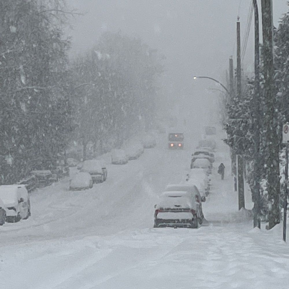
45 mph gust so far 💨 💨
Between 9pm-3 am there a good chance of cracking 50
East winds returning right on schedule. Already had a gust to 35 mph at ext. 32 I90 at 5 am. Winds due to an even stronger offshore Low (975 mb) than Saturday, but this one will stay further away, curling up well into BC. Expect about this intensity all day, until ~8pm.
28.10.2025 13:27 — 👍 0 🔁 0 💬 0 📌 0
Nice iridescent cloud over Lake WA this afternoon
07.10.2025 00:12 — 👍 7 🔁 0 💬 0 📌 0
First smoke sun of the season
Sugarloaf fires near Wenathchee have really expanded
AQ not expected to significantly improve until onshore flow and cooler moist air returns this weekend
Consecutive days at or above 90° after August 15th
From previous records available at Snoqualmie Falls (records stopped in 2008)
1 8/22-26 2025 5 (days)
2 8/15-17 1927 3
3 8/24-26 1916 3
4 8/19-20 2004 2
5 9/2-9/3 1988 2
Update from WSDOT 1:45p
"CANCELED: The five-day closure of State Route 18 scheduled for May 15-21 has been cancelled due to forecast rain. It will be rescheduled to a later date. "
@wsdot.wa.gov

Looks like around 7pm things are going to get wild
27.03.2025 00:56 — 👍 7 🔁 2 💬 0 📌 0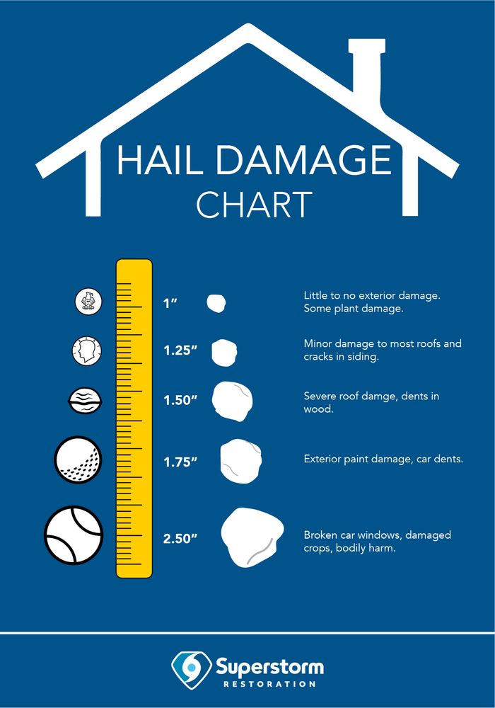
The risk is low for >1" hail, but that risk is not zero
Main timing for the convective outbreak to move northward to the Puget Sound region still looks to be ~6-8pm
#wawx #convectiveoutbreak
Aircraft taking off to the north today. That means at least one more nice day. Uhh..make that exactly one more day. Rain returns Sunday. Enjoy the early spring while it lasts!😎
01.03.2025 00:11 — 👍 2 🔁 0 💬 0 📌 0
Felt that one!
#waquakes
I90/SR18 station recorded 47 mph gust this am
Our 9th windstorm (8 of 9 E winds) with a gust >=40 mph this fall/winter season, par for the course, but our 4th major power disruption which I believe is on the high side. First storm having southerly winds that strong this season.

Not out of woods yet. Peak gust potential remains through ~ noon.
We've had max gust 37 mph at I90/SR18 xchange, and same out at ext 32 in North Bend, thus far relatively unscathed
Out west, Boeing Field clocked a 60 mph gust.
Outage map says it all re: strongest winds

Send in those weather station wind gust reports tonight/tomorrow am!
#wawx

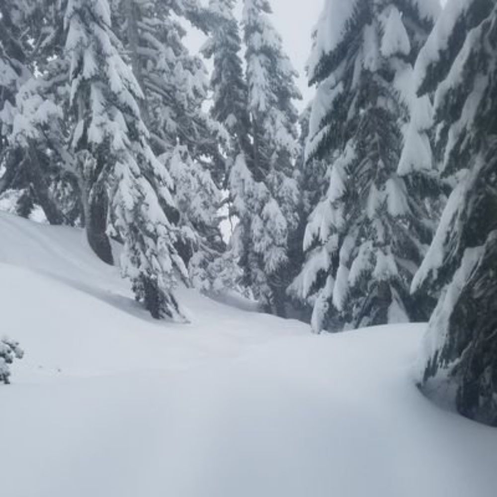
Another 3.5" (13" since last Sunday). This has been a perfect setup out here, nothing that buries us, but a good shot each day with no east winds drying out the air and knocking the beautiful snow off the trees.
08.02.2025 15:06 — 👍 5 🔁 0 💬 0 📌 0
Another 3" at HQ (~800ft.). 10" since Sun, surpassing last year's 5-yr low of 7" for the entirety of the 2023-24 season. Measurable snow before midnight Fri would be 6 days in a row, a new record since I started writing this stuff down in 2018.
06.02.2025 15:35 — 👍 7 🔁 2 💬 0 📌 0
Morning
04.02.2025 16:03 — 👍 2 🔁 0 💬 0 📌 0Nice flakes, heavier wet snowfall
02.02.2025 18:59 — 👍 7 🔁 1 💬 0 📌 0
Well this is a good start! ❄️
01.02.2025 15:10 — 👍 8 🔁 1 💬 0 📌 0😎
01.02.2025 04:24 — 👍 1 🔁 0 💬 0 📌 0
Cold and beautiful
22.01.2025 17:09 — 👍 10 🔁 0 💬 0 📌 0
That makes three!
21.01.2025 01:22 — 👍 4 🔁 2 💬 0 📌 0
Feel that?
20.01.2025 21:46 — 👍 2 🔁 1 💬 0 📌 1That rivals my father-in-law’s ham radio antenna 👍
13.01.2025 03:50 — 👍 1 🔁 0 💬 0 📌 0Another windy night, should be past peak now
45 mph - North Bend (Ext 32 I90)
37 mph - Snoqualmie (Ext 25)
34 mph - Snoqualmie (MSHS)

In the near-term we have these east winds picking up strength Friday morning, peaking ~30-40 mph around 7 am.
Ho-hum weather outlook otherwise. We're likely to remain above normal temperatures for this time of year.
Ensos have some statistical significance for the mountains, but lowlands are more random. Snoqualmie Pass is actually well ahead of last year (acc. 126" vs 79" through Dec 31)
01.01.2025 04:20 — 👍 0 🔁 0 💬 1 📌 0
No lowland snow for December. But all is not lost for snow fans. Jan and Feb can really deliver out here.
#HappyNewYear2025
The wind threat has now turned from out of the south with brief surges of gusts ~50 mph possible through ~ 1 pm
Overnight we had a max gust of 44 mph in North Bend and 41 mph in Snoqualmie
Rain increasing with one-two punch of howling winds tonight/early Thurs. Peak gusts, first out of east 35-45 mph overnight, then turning southerly after 7 am, those gusts to 50 mph possible until ~noon, but more likely that strong out on the Sound.
Shouldn’t get any worse the rest of the year😉