A long view over the snowy boreal forest east of Fairbanks, Alaska shows some of the heights of the White Mountains. Though the sun is clearly low in the sky, casting pinkish hues on the snow, this picture was taken in the early afternoon. In the foreground, several tall spruce trees poke out of the surrounding forest.
Four years ago today, this was my view on a hike along the Steese Hwy. outside of Fairbanks, Alaska. I've since learned that the Arizona sun makes my cheeks tingle the same way zero F does.
Maybe that's bad, but it's real. What more can you ask for?
#hiking #outdoors #Alaska #photo #landscape
25.01.2025 04:27 — 👍 11 🔁 0 💬 0 📌 0

Three channels of the braided Teklanika River in Denali National Park, Alaska, flow across a wide gray gravel river bed. In the background, low shrubs line the distant bank before turning into black spruce forest. Beyond the forest, several low peaks of the Alaska Range rise toward a stretch of bright blue sky featuring several lenticular clouds. Taken June 24 2020.
In June 2020, the pandemic gave me the rare chance to drive my own car into Denali NP. It was a dark time, but one of the best days of my life.
Today, this view of the Teklanika River is my reminder that there is always light somewhere in the darkness.
#nature #landscape #Denali #inauguration
20.01.2025 16:37 — 👍 11 🔁 0 💬 0 📌 0
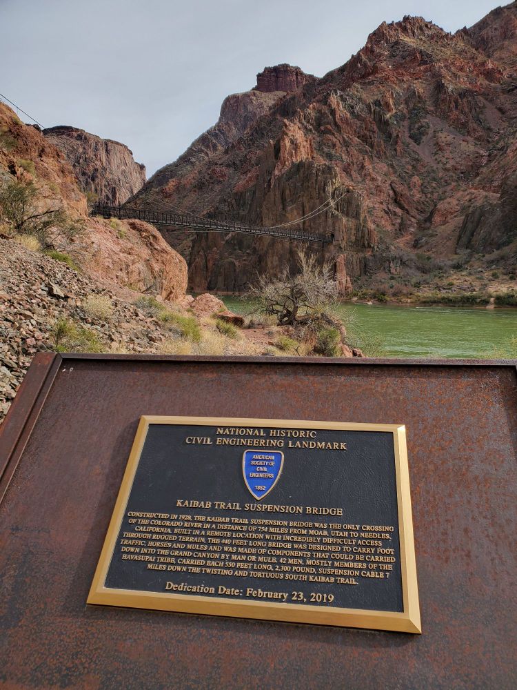
The Black Suspension Bridge, a dark structure that blends into the shadowed red rocks behind it, crosses the green waters of the Colorado River at the end of the South Kaibab Trail into the Grand Canyon. This National Historic Civil Engineering Landmark, a plaque about which is in the foreground, was completed in 1928. In the era before helicopters, all of the beams, cables, manpower, and supplies had to be carried down the 7-mile trail. Much of this back-breaking labor was done by members of the Havasupai tribe. Today the bridge still serves as the crossing point from the South Kaibab Trail to Bright Angel Campground and Phantom Ranch.
The Black Suspension Bridge over the Colorado River at the bottom of the Grand Canyon is proof that humans can do incredible things when we work together. Read the plaque to be amazed.
#hiking #grandcanyon #Arizona #positivity #alltogethernow #outdoors #infrastructure #havasupai
15.01.2025 17:26 — 👍 10 🔁 1 💬 0 📌 0

The Santa Rita Mountains stretch out across the full width of the image. A few puffy clouds overhead and a late afternoon sun (out of frame, right) cast indigo shadows on the peaks and throw the topography into relief. The eastern (left) line of peaks, including Mt. Wrightson, is almost completely hidden under an unbroken bank of pure white clouds that are spilling over from the other side of the range. The western (right) peaks, including Mt. Hopkins and its Whipple Observatory, are clear. In the foreground, yellowed grass betrays the winter season despite the still-green mesquite trees and the presence of a few palms.
This morning's heavy mist finally lifted and gave us this gorgeous view of a cloud bank rolling over the Santa Ritas. Beautiful day even with the wind. I'll never tire of the shadow play on this range.
#outdoors #nature #weather #photography #arizona #santaritamountains #clouds
09.01.2025 00:29 — 👍 14 🔁 0 💬 0 📌 0

A dozen researchers from Birmingham and Oxford Universities, all clad in yellow hi-vis vests and hard hats, work to excavate a line of dinosaur tracks from the Jurassic period. The tracks stretch across a wide, flat gray dirt plain, and are crossed by another dinosaur trackway at roughly a 90-degree angle. The indentations of the footprints are visible even from the drone-height at which the image was taken. In the background are two tents and two vehicles, as well as small hills of stone in darker shades of gray and black.
Main article/image: https://www.npr.org/2025/01/04/nx-s1-5248283/jurassic-footprints-dinosaur-highway
Univ. of Birmingham dropped this image of a dinosaur trackway excavation (link to article in Alt Text). Really puts dinosaurs' size in perspective. A person could lay down between two of those prints. Skeletons don't convey locomotion, life, like this does.
#nature #dinosaurs #paleontology #wow
06.01.2025 17:12 — 👍 15 🔁 5 💬 0 📌 1
He's actually smack dab in the middle, at the base of the post. It took us a long time to spot him; we only did once he rattled.
06.01.2025 02:19 — 👍 0 🔁 0 💬 0 📌 0

A hiker is silhouetted on the Appalachian Trail in Smoky Mountains NP, Tennessee, in May 2022. Rays of morning sun shine through a small gap in the verdant foliage pressing in on the muddy, rocky trail.
Oh, to be hiking on a morning such as this!
(After two days of downpours, the morning sun was a relief!)
Appalachian Trail, Smoky Mountains NP, Tennessee, May 2022
#hiking #appalachiantrail #AT #outdoors #tennessee #publiclands #smokymountains
05.01.2025 14:29 — 👍 8 🔁 0 💬 0 📌 0
Oh, no, that was in September! I haven't seen any recently.
30.12.2024 16:02 — 👍 0 🔁 0 💬 0 📌 0

Several ancient petroglyphs (images made by scratching away the weathered layers of stone to reveal lighter rock beneath) line the edge of a large boulder in Central Arizona's Tonto National Forest. The exposed rock is rounded and worn from water (this is right above a seasonal watercourse) and wind. Behind it, a sloping field dotted with Saguaro cacti leads up to sheer rock heights and a bright blue, cloud-smattered sky.
I've wanted to hike in the Superstition Mountains since my first visit to Arizona 13 years ago, and got my wish for my birthday. Couldn't have asked for a better introduction.
Day 12 of 12 Days of Public Lands
Petroglyphs in the Superstition Wilderness, Tonto Natl Forest, AZ. The route to these amazing markings literally starts in a neighborhood. Talk about a treasure in your backyard!
#hiking #outdoors #petroglyphs #Arizona #publiclands #tontonationalforest
30.12.2024 15:57 — 👍 7 🔁 1 💬 0 📌 0

Dawn paints the distant North Rim of the Grand Canyon with shades of orange, yellow, and white. The depths of the Canyon are still blue, purple, and brick red with shade; faint dustings of snow along the steep slopes to the left announce the season. In the middle foreground, a train of mules carries supplies down into the canyon. Juniper and other high altitude trees frame the South Kaibab Trail along which the train is descending.
I was extremely fortunate to be able to hike down to the canyon floor and spend a night at Phantom Ranch in 2024. It was one of the most exhilarating experiences I've had, and serves as a constant reminder that every step along the trail is worth it.
Day 11 of 12 Days of Public Lands
National Parks are the Crown jewels of America. What captures the Western spirit more than a mule train descending into the Grand Canyon at sunrise?
#hiking #outdoors #grandcanyon #publiclands #sunrise #nationalparks #southkaibabtrail
29.12.2024 16:15 — 👍 23 🔁 2 💬 0 📌 1

The Tumacácori Mountains are visible beyond trees displaying bright yellow fall leaves. A low hill covered in brown dry grass and old deadfall trees fills the foreground.
This stretch of the Juan Bautista de Anza National Historic Trail runs between Tubac and Tumacácori, AZ. The overall trail runs from within Mexico to San Francisco. The 4-mile stretch pictured here is a great little out-and-back (8ish miles total) if you start from Tubac. Tumacácori boasts the Tumacácori Natl Historic Park (fee required), including intact Spanish mission buildings and a neat little museum. Just up the road from the Historic Park is Wisdom's, a café with solid Mexican food and 2-for-1 margaritas on Tuesdays.
Day 10 of 12 Days of Public Lands
Fall colors on display along the Juan Bautista de Anza (cool story, check him out) Natl Historic Trail. I love how this trail knits modern settlements, nature, and history together seamlessly.
#hiking #outdoors #nature #fall #publiclands #juanbautistadeanza
28.12.2024 15:30 — 👍 6 🔁 0 💬 0 📌 0

A bright red metal post marks a point where Pima County, AZ's Adamson-Catino Trail dips under a railroad bridge. In the dry grass at the base of the post is a large rattlesnake cooling off in the shade (it was well into the 90s Fahrenheit that September day). It was close enough to the trail to rattle when we were still about fifteen feet away, so it was turnaround time for us.
Day 9 of 12 Days of Public Lands
Another Pima County-maintained space today; Canoa Preserve Park. We attempted a short hike on the Adamson-Catino Trail in Sept., but this rather large rattlesnake (can you spot him?) was gatekeeping.
#hiking #outdoors #publiclands #rattlesnake #wildlife
27.12.2024 15:44 — 👍 4 🔁 0 💬 0 📌 0

The remains of the brick officers' quarters at Ft. Union National Monument near Watrous, New Mexico have weathered down to look like natural stone pillars. A close look reveals the holes for wooden window and door lintels,, now gone. Bare dirt in the foreground, desert grasses stretching out beyond the structure, and the stormy skies overhead provide a glimpse of the natural challenges soldiers stationed here during the Civil War faced.
The ruins have both an accessible trail as well as some slightly more challenging areas that provide extra views over the high plains. It's very well signposted; we learned a lot on our visit even though the visitor center was closed that day (bathrooms were unlocked, fortunately). This is a great, and fee-free, stop along I-25 if you have a couple of hours to stretch your legs.
Day 8 of 12 Days of Public Lands
New Mexico's Ft. Union Natl Monument is a hidden gem off I-25 near Watrous (which boasts a great little coffee house, BTW). Want to see Civil War history in the desert? Here you go. Great signage, too.
#outdoors #history #publiclands #civilwar
26.12.2024 16:14 — 👍 8 🔁 0 💬 0 📌 0

The limestone walls of Montezuma Castle, a 900-year-old multifamily dwelling built by the Sinagua people, blend into the sheer cliff around the structure. Set back in a natural alcove in the cliff face, the structure was aligned to receive the warming desert sun in winter and sit in cooling shadow during the summer. Being located 90 feet above the ground also protected the inhabitants from seasonal flooding in nearby Beaver Creek, and may have served a defensive purpose against other groups of humans.
The verdant trees filling the foreground are evidence of why the Sinagua chose this site for their community. Beaver Creek not only supports a riparian landscape that allows different wild plants and animals to thrive than do in the dry grasslands over the cliff's edge, its water is reliable enough to have been diverted for agriculture. There is ample evidence of the Sinagua utilizing both wild and purpose-grown foods and materials in their daily lives.
Day 7 of 12 Days of Public Lands
Montezuma Castle Natl Monument is a testament to humans' knack for making a comfortable home anywhere. Under a cliff beside a seasonal river? Perfect place for an apartment building. Even climate-controlled. Brilliant.
#outdoors #publiclands #Arizona #sinagua
25.12.2024 17:35 — 👍 6 🔁 0 💬 0 📌 0

On a warm June day, the crinkled contours of Beloit (left) and Blackstone Glaciers stand out below the smooth plain of their parent icefield in Chugach National Forest, Alaska. The depth of the glacial fall lines can be seen even from a mile away due to their dark blue hue. The calm waters of Prince William Sound's Blackstone Bay lead up to the glaciers in the foreground, while a bright blue sky with one long, trailing cloud serves as a backdrop for the towering mountain peaks.
The rich wildlife that Chugach NF helps preserve was on full display the day this picture was taken, with sea lions, seals, humpback whales, and many flocks of seabirds making an appearance during the trip out to the glaciers.
Day 6 of 12 days of Public Lands
On the coastal side of the Chugach National Forest, tidewater glaciers drop from summit to sea. Chugach NF helps protect these glaciers and the many marine species that call Prince William Sound home.
#outdoors #glaciers #publiclands #Alaska #nationalforest
24.12.2024 15:17 — 👍 9 🔁 1 💬 1 📌 0

A section of the Chugach Mountains (Chugach National Forest, Alaska) are still about 50% covered in snow in this image from late May 2024. The difference in temperature between the near-sea level foreground and the summit is demonstrated by a swath of fully leafed-out birch and willow trees.
This section of the Chugach Mountains generally loses all of its snow by peak summer, with melt helped along by near-constant sunlight. However, around 30% of the National Forest is ice-covered all year.
Day 5 of 12 Days of Public Lands
The Chugach Mtns still had plenty of snow on them in late May. Southcentral Alaska's 6.9m acre Chugach Natl Forest, the second largest National Forest in the country, surrounds Prince William Sound (tomorrow's image).
#outdoors #publiclands #Alaska
23.12.2024 18:46 — 👍 9 🔁 0 💬 0 📌 0

A view into the mud-brick remains of Casa Grande, a large town of the Ancestral Sonoran Desert People. Although the main building has been damaged by centuries of weathering and from human activities, it still offers a peek into the past, with individual rooms and passageways evident. The metal roof overhead may not be aesthetically pleasing, but it helps to preserve this important site for future generations.
Day 4 of 12 Days of Public Lands.
Public lands are history as well as nature. Casa Grande Ruins Natl Monument protects 700+-year-old evidence of the Ancestral Sonoran Desert People. Amazing, the genius required to build a town from sand and cacti.
#nativeculture #publiclands #history #casagrande
22.12.2024 14:22 — 👍 6 🔁 0 💬 0 📌 0
Love that description, distraction magic. That's exactly what it is, 100%. And the fuzzy edges don't help. Somehow it's more difficult to visually locate the border of the area of effect on a cholla than on, say, a barrel cactus.
22.12.2024 02:51 — 👍 0 🔁 0 💬 0 📌 0
And it's NOT for a pleasant embrace, either. 😂
22.12.2024 01:39 — 👍 1 🔁 0 💬 1 📌 0
The yellow-orange winter sun shines through a silhouetted stand of spruce and birch trees at midwinter in Fairbanks, Alaska. Although Fairbanks doesn't have completely dark days like some more northerly Alaskan communities, the sun hugs the horizon around solstice. A haze of ice fog - a common feature of Fairbanks winters thanks to extreme cold temps that cause an inversion layer - fills most of the sky. One of the broad, snow-covered fields of Creamer's Field Wildlife and Migratory Waterfowl Refuge fills the foreground. Closest to the viewer, a wide path plowed firm to allow for cross-country skiing and skijoring sweeps gently down and to the right.
Okay, Southern Hemisphere, it's our turn with the big glowing ball in the sky again, please and thank you.
Happy Solstice!
(Photo taken at Creamer's Field Wildlife and Migratory Waterfowl Refuge, Fairbanks, Alaska.)
#solstice #winter #outdoors #alaska
21.12.2024 16:30 — 👍 8 🔁 0 💬 1 📌 0

A densely vegetated Sonoran Desert landscape shows several large Jumping Cholla surrounded by buffelgrass. The unusual 'reaching' shape of Jumping Cholla's spiny segments and their tendency to easily detach from the parent plant give this cactus its active epithet.
Two adult Saguaro cacti can be seen midframe. Neither have arms yet, and so are likely no more than about seventy years old. Further in the background, mesquite trees and an ocotillo can be seen. The Quinlan Mountains run behind the entire scene, with the dome of Kitt Peak National Observatory just visible at the top of Kitt Peak.
Day 3 of 12 Days of Public Lands.
Roaming Arizona's public lands, I've learned to identify desert plants like Jumping Cholla, seen here in Tucson Mountain Park. Maybe Kitt Peak Natl Observatory (left of the summit) will find a Jumping Cholla Nebula someday? 😂
#hiking #plants #kittpeak #publiclands
21.12.2024 16:15 — 👍 9 🔁 0 💬 2 📌 0
February snow dusts the top of Mt. Wrightson in the Santa Rita Mountains south of Tucson. The full range of ecosystems in the Santa Ritas, one of the Madrean Sky Islands of Southern Arizona, is visible, from the low desert scrub in the foreground to the dark green evergreen forests of the mid-slopes to the frozen (at least in winter) peak. The foreground is flat, and features clusters of mesquite trees showing the first blush of spring green.
This image was taken in Pima County's Canoa Hills Trails Park, a 130-acre re-wilded golf course with 5.5 miles of maintained trails, several shaded picnic tables, and benches. The site is a huge favorite with locals, who appreciate having a quiet outdoor retreat - complete with daily sightings of javelina, coyotes, and other Sonoran wildlife - just steps from their front door.
Canoa Hills Trails Park is a great example not only of the massive impact that small public lands sites can have on the quality of life for residents but also of how public lands can be reclaimed and fostered when industry or commerce have moved on. Having walked in this park dozens of times, I was shocked to learn that it's only 130 acres. The ever-changing views, compact trails (formerly the golf cart paths, now cross-cut with some unpaved dirt routes), and high level of wildlife activity make it feel much, much larger.
Day 2 of 12 Days of Public Lands.
There are tons of great public land sites that aren't Federal! Pima County, AZ maintains Canoa Hills Trails Park, a 130-acre re-wilded golf course. Both people and wildlife love this neighborhood retreat. See Alt Text for more.
#hiking #publiclands #smallparks
20.12.2024 16:07 — 👍 9 🔁 1 💬 0 📌 0

A mid-January afternoon in Mund's Mountain Wilderness, Coconino National Forest, Arizona. A small amount of snow lines the red rock trail around Courthouse Butte near Sedona. High altitude trees still display bright greenery despite the recent chill. A section of Courthouse Butte rises in the background, its blocky, squarish shapes displaying alternating layers of reddish and white rock. A few thin clouds are just visible at the edges of the bright blue winter sky.
To wrap up 2024, I've decided to post 12 pics (1 per day) I took on Public Lands this year. In 2025, these precious spaces will need us to value, protect, SHARE (there's no zealotry like that of the convert), and enjoy them more than ever.
Location is in Alt Text.
#hiking #outdoors #publiclands
19.12.2024 16:03 — 👍 13 🔁 0 💬 0 📌 0

A view down the valley below Arcosanti, featuring high desert scrub and, in the background, one of the community's crop fields. In the left foreground, several cypress trees help shade a work area. Arcosanti is built into a cliff face to take advantage of the natural heating and cooling features of the earth.

The ceramics workshop at Arcosanti. The wide domed ceiling allows ample natural light into the workspaces while also ensuring that there is a shady area at virtually all times of day.

The Cosanti Foundation mission statement, written in red, yellow, and blue chalk inside Arcosanti. It reads: "to inspire a reimagined urbanism that builds resilient and equitable communities sustainably integrated with the natural world."
A few shots from a visit to Arcosanti, Paolo Soleri's arcology (ecological archtitecture) opus. What a different world it would be if more arcology principles were widely applied.
#arcology #arcosanti #environment #ecology #climatechange #travel #arizona
14.12.2024 14:56 — 👍 8 🔁 0 💬 0 📌 0
It's a film worth bundling up for!
14.12.2024 13:39 — 👍 0 🔁 0 💬 0 📌 0
This looks eerily like a shot from the high country in interior Alaska. Gave me some big childhood vibes. 😅
13.12.2024 04:01 — 👍 1 🔁 0 💬 0 📌 0

Two red gravity chairs sit in a field of high, pale grass overlooking Parker Canyon Lake in Southern Arizona. The Huachuca Mountains rise into a streaky-clouded sky in the background.

A western arm of Parker Canyon Lake in Southern Arizona shows bright blue under a bright December sun. A forest of juniper and other high-altitude trees rises above broad sloped beaches. The Canelo Hills rise in the background.

A view from one of Parker Canyon Lake's many wide, rocky beaches. Facing north-northeast across one of the more southerly arms, toward the bulk of the lake. A calm strip of water is seen angling through rougher areas as the arm turns into the main body. Both background banks are covered in golden December grass dotted heavily with juniper and other montane woodland foliage. Overhead, a few high, streaky clouds threaten to move in front of the mid-afternoon sun.
Enjoyed two gorgeous days at Parker Canyon Lake this weekend. Wonderfully quiet, only two other tent campers the whole trip. Breaking down camp in 30 mph gusts was an adventure, but nothing blew away, so it's cool. 😅
#camping #Arizona #hiking #publiclands #cochisecounty
12.12.2024 05:47 — 👍 9 🔁 0 💬 0 📌 0

The broad expanse of the San Rafael Valley, dotted with mesquite and juniper, sweeps southward toward the Mexico border. Viewed from Montezuma Pass in Cochise County, Arizona.
Capped off our camping trip with this sweeping view of the San Rafael Valley from Forest Road 61. Can't wait to come back with more time to do some hiking, including the beginning stretch of the #ArizonaTrail.
#hiking #outdoors #arizona
11.12.2024 05:05 — 👍 6 🔁 0 💬 0 📌 0
Dropped $50 on a grown-up frying pan instead of something from the dollar store, and I had no idea what I was missing. They should hand out adult frying pans at high school graduations. Game changer.
#adulthood #cooking #waxingpoeticaboutfryingpans #yesiknowthisisnttumbler #mytagsneedtobreathe
08.12.2024 13:50 — 👍 1 🔁 0 💬 0 📌 0

A white-hot sun begins to dip below the ridge of the mountains to the southwest of the Sunset Point rest area along I-17. In the middle and foreground is a wide basin featuring rolling, flat-topped hills. The grass and other foliage is mostly brown due to December temperatures, but a few mesquite trees still show green leaves.
Sometimes highway pulloffs make up for the necessity of re-passing all the slow pokes once you get back on the road. Sunset Point along I-17 is one of them.
#roadtrip #landscape #nature
06.12.2024 17:08 — 👍 4 🔁 0 💬 0 📌 0