A Severe Thunderstorm Warning is in effect for #AshtonCreekBC and #KingfisherBC. At 5:27 p.m., a severe thunderstorm capable of producing strong wind, up to nickel size hail and heavy rain was located east of Ashton Creek is moving northeast at 40 km/h. #BCwx #BCStorm #vernonbc
30.05.2025 00:39 — 👍 2 🔁 0 💬 0 📌 0

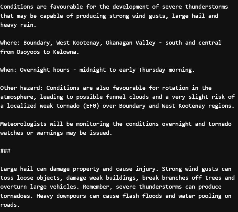
Time for some severe weather in BC! A #SevereThunderstormWatch has been issued the #Okanagan - #BoundaryBC, West Kootenay, Okanagan Valley - south and central from #Osoyoos to #Kelowna.. A TORNADO RISK IS CITED WITH THE WATCH... Stay tuned for further watches and warning! #BCStorm
26.03.2025 23:02 — 👍 5 🔁 1 💬 1 📌 0
#TSUNAMI WARNING CANCELED... NO THREAT TO #BC. #BCwx
05.12.2024 20:00 — 👍 0 🔁 0 💬 0 📌 0
NO THREAT TO #BC YET... Emergency Mgmt BC is currently evaluating the risk for BC. Stay tuned for more info. #Tsunami #BCwx
05.12.2024 19:38 — 👍 3 🔁 2 💬 0 📌 1
Going to wait for the Twitter wave to die down, then going to switch to my bcwx.ca handle!
22.11.2024 02:48 — 👍 1 🔁 0 💬 1 📌 0

Did you receive an #AlertReadyTest today? Consider taking the following survey so @AlertReady can improve their systems: peasi.com/emergency-al...
#AlertReadyTest #AlertReady #TestAlert #Vancouver #BC
20.11.2024 22:04 — 👍 3 🔁 1 💬 0 📌 0

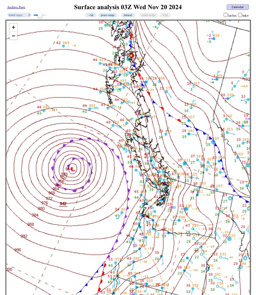
A surface weather analysis showing a 942 mb low west of Washington with an occluded front wrapping around it.
WPC analysis shows the #BombCyclone bottomed out at 942 mb at 03z (19 PT). This ties the record set in October 2021.
#weather #BCstorm #WAwx #ORwx
20.11.2024 19:57 — 👍 37 🔁 11 💬 0 📌 0
Current look at the #Whistler Snow Ruler over the last 24 hours, and 33 cm of snow was picked up. Snow accumulation began around 8:00 PM last night.
#BCwx #BCSnow #SeaToSky #BCStorm
20.11.2024 17:13 — 👍 11 🔁 2 💬 0 📌 0
The wind warning that was in effect for #MetroVancouver is now canceled. Wind speeds are no longer expected to meet warning criteria, but SPECIAL WEATHER STATEMENT has been re-issued for the continued risk of strong winds.
#BCStorm #BCwx #Vancouver #BCWind
20.11.2024 07:26 — 👍 7 🔁 0 💬 0 📌 0
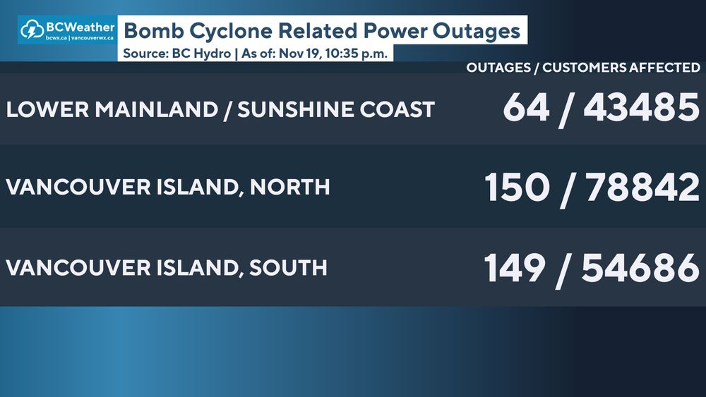
Bomb Cyclone Related Power Outages as of: Nov 19, 10:35 p.m
Here is a look at the current number of @bchydro power outages across regions affected by the bomb cyclone, as of 10:35PM.
#Vancouver #VancouverIsland #SunshineCoast #BCStorm #BCwx @paulhaysom.bsky.social @jarmstrongbc.bsky.social
20.11.2024 06:42 — 👍 8 🔁 5 💬 0 📌 0
942mb bomb cyclone!! Likely the lowest pressure ever recorded in this area of the Pacific Ocean #wawx
20.11.2024 06:13 — 👍 108 🔁 30 💬 3 📌 3

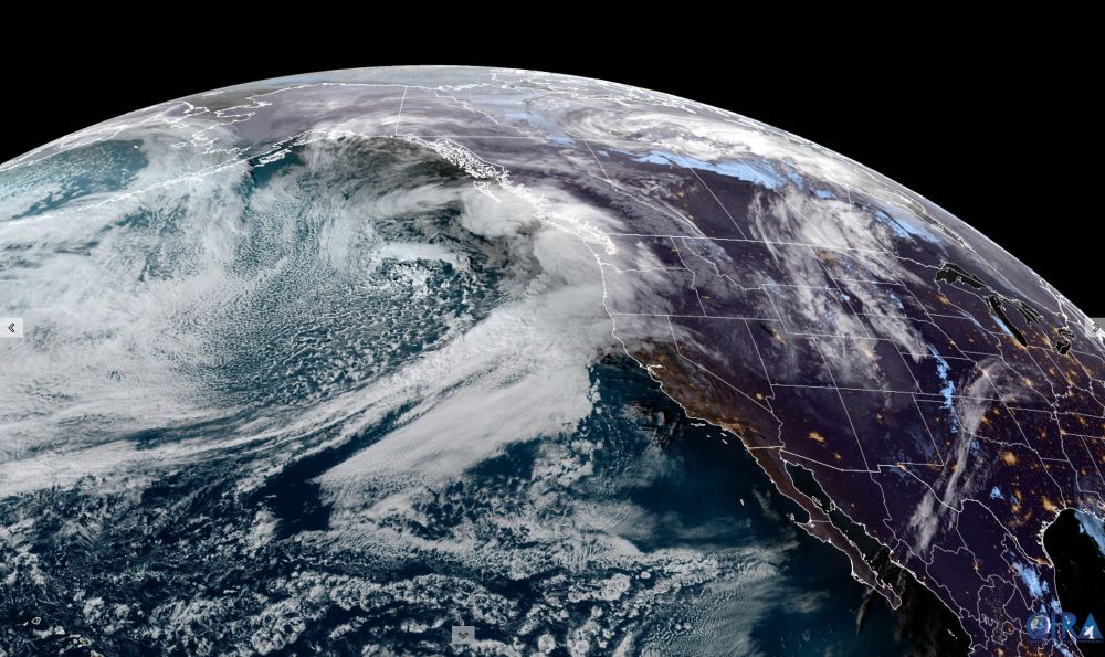
GOES-West Satellite picture @ 9:10PM PT
What a beast of a storm... this "super" bomb cyclone dropped 66mb in 24hrs. To be classified as a bomb cyclone, a low has to drop 24mb in 24hrs (1mb/hr). Truly a beauty looking down from satellite.
#bcstorm #wawx #bcwind #bcwx #wawinds #bombcyclone
20.11.2024 06:00 — 👍 20 🔁 5 💬 1 📌 0

9 p.m. update from BC Hydro. #bcstorm
For up to date information on outages visit www.bchydro.com/power-outage...
20.11.2024 05:16 — 👍 6 🔁 2 💬 2 📌 0

I stitched together the BCHydro outage map to give an idea of the current outages on the south end of VI. #BCstorm
20.11.2024 05:20 — 👍 29 🔁 8 💬 0 📌 0
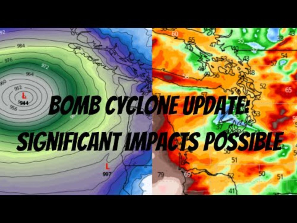
YouTube video by Western Washington Weather
Bomb Cyclone Update: Significant Impacts Possible
Bomb Cyclone Update: Significant Impacts Possible
#wawx
youtu.be/6t3nJtis4SQ
17.11.2024 21:42 — 👍 13 🔁 4 💬 3 📌 0
I feel bad for 0.1% of the online population that uses it....
13.11.2024 21:43 — 👍 1 🔁 0 💬 1 📌 0

There is minor instability in the atmosphere across #MetroVancouver, that may lead to a few possible rumbles of thunder. WHEN: Tonight through early tomorrow morning.
#BCStorm #BCwx #BCStormWatch #VancouverBC
13.11.2024 21:02 — 👍 0 🔁 0 💬 0 📌 0

IEMBot Image TBD
#SPC issues Day 1 Marginal Convective Risk at Nov 13, 5:28z for SEW link
13.11.2024 05:30 — 👍 3 🔁 1 💬 0 📌 0
Me as well. Will be posting updates under the hashtag.
13.11.2024 03:37 — 👍 4 🔁 0 💬 1 📌 0
Great Scott!
13.11.2024 03:32 — 👍 0 🔁 0 💬 0 📌 0

69 years ago.....
at exactly 10:04pm
Lightning struck the clock tower in Hill Valley
13.11.2024 02:50 — 👍 28 🔁 5 💬 2 📌 2

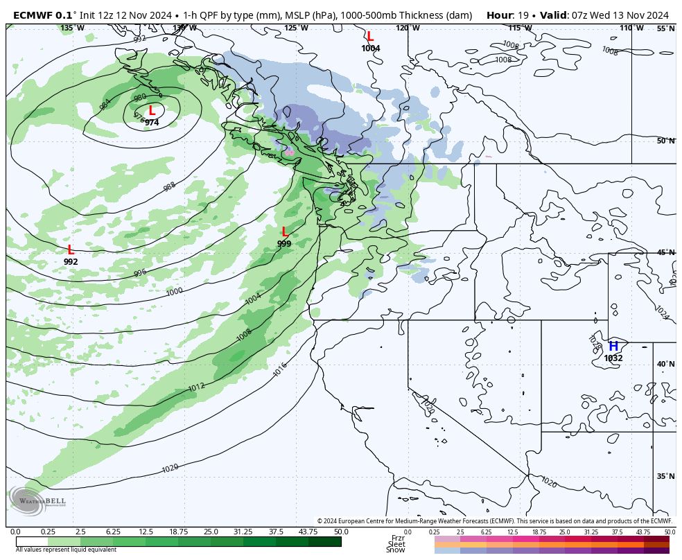
Euro model wind gusts 11PM PST

Canadian model wind gusts 11PM PST
Frontal low system that will be pushing through.
We're still expecting strong winds in and near the #HaroStrait. WHAT: Wind up to 70km/h and gusts up to 90-100 km/h. WHEN: This evening to early Wednesday morning. WHERE: The Haro Strait, near #VictoriaBC, #StraitOfGeorgia and Southern #MetroVancouver.
#BCStorm #BCwx #BCStormWatch #BCwind
13.11.2024 00:29 — 👍 1 🔁 0 💬 0 📌 0
These are really cool... thanks for putting this one together. Also, can I be added as well?
12.11.2024 23:44 — 👍 2 🔁 0 💬 1 📌 0
... including #Seattle, #Portland. A risk of a thunderstorm is also present for #MetroVancouver, for tomorrow. (2)
#wawx #bcwx #bcstorm #bcweather #VancouverIsland
12.11.2024 19:29 — 👍 0 🔁 0 💬 0 📌 0

The US Weather Service Storm Prediction Center has issued a Thunderstorm risk for the Washington and Oregon coasts, a thunderstorm is also possible for extreme southwestern coast of Vancouver Island. TOMORROW: A Marginal risk for the same places, with a tstm risk for places more inland... (1)
12.11.2024 19:27 — 👍 5 🔁 1 💬 1 📌 0

Euro Model valid 11PM, November 12. Wind gust parameter.
Euro Model valid 11PM, November 12. Precip parameter.
STRONG WINDS EXPECTED TONIGHT
A frontal system going to push through late this evening into tomorrow, that will bring southeasterly winds up to 70km/h, with gusts up to 100km/h expected. Models are expecting the bulk of the winds at the Haro Strait by 11PM and midnight.
#BCStorm #BCWX #BCStormWatch.
12.11.2024 19:10 — 👍 7 🔁 2 💬 0 📌 0

IEMBot Image TBD
WPC issues Day 1 Marginal Risk Excessive Rainfall Outlook at Nov 12, 7:44z for SEW link
12.11.2024 08:16 — 👍 3 🔁 3 💬 0 📌 0
Science reporter for CBC News.. background in meteorology + seismology
✈️International Storm Chaser & MyRadar Storm Tracker
🌪️Extreme Cinematic Tornado drone pilot
🎥Media Inquiries: jordanhallwx@gmail.com
#ChaseYourDreams
I make videos and own too many floppy disks.
📸 - youtube.com/MichaelMJD
✉️ - michael@teammjd.com
feeling bisky right now
http://www.dvd3000.ca
https://linktr.ee/tentimesfriday
Multimedia Journalist at CHEK News- SAIT Alumni - Lover of Trash 📺 - Personal Account
Story idea? email me: mread@cheknews.ca
She/Her
Wildlife, bird and landscape photographer and hope to travel more around the world in the next four years to keep my sanity.
Official account for the Township of Langley. Birthplace of BC and a proud community unlike any other since 1873. #LangleyTownship
tol.ca/social
Blogger, media analyst, copy editor at the Montreal Gazette. https://blog.fagstein.com
A bot to provide Coquihalla BC Summit weather updates. It provides information based on the publicly available observation data through Drive BC API.
❄️☀️⚡️⛈️🌩️ 🌧️☁️
This is an unofficial weather bot.
Managed and automated by @khanjakee.bsky.social
Donnie and Dhali weekdays Monday to Friday 10am-noon on CHEK TV.
National Meteorologist l Spectrum News
Meteorologist at KTIV News 4 ☀️
Iowa State Alumni 🌪️
Storm Chaser 🌪️🏃♀️
Go Pack Go 💚💛
Husband to an amazing wife and soon to be Dad | Meteorologist - B.S. Iowa State | Storm/Aurora Chaser
Print Store link!: https://therealworldphotography.net/
NMP was founded by Western University & ImpactWX and aims to connect and enhance Canada's weather networks. Creator of the Canadian Mesonet Portal. @meso.cssl.ca
Ethnically ambiguous, elder Gen-Z cat-loving, goofy, amateur Vancouver tour guide. Food wonk, news guy.
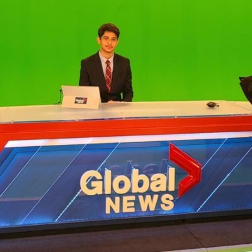
CKNW / Global BC Anchor/Reporter
kareem.gouda@globalnews.ca
Certified Broadcast Meteorologist @FOX8NOLA
Former: @CNN @KSWO7NEWS @KKTV11News
@ou_meteorology Alum | Boomer Sooner | Who Dat ⚜️
Univ. of Miami hurricane researcher 🌀 living in New Mexico 🏜.
Husband and dog dad. 🏳️🌈
https://bmcnoldy.earth.miami.edu/
Meteorologist/Dad/Partner/Son/Brother.. My views/thoughts. 100% weather radar nerd.