🚨 🚀 A crude interface I built to expose an archive of College of DuPage GOES imagery since about 15 Apr 2017. The archive is around ~500TB in size over ~2.5 billion JPEG images. Yikes, but here you go.
mesonet.agron.iastate.edu/archive/cods...
Anyways happy for feedback. Not worth the effort?
13.01.2026 22:50 — 👍 78 🔁 17 💬 11 📌 9
when you intercept an anti vaxer it's known as a prick six
13.01.2026 04:07 — 👍 609 🔁 104 💬 4 📌 3
Best TikTok thing going is the two dudes trying food from every country without leaving NYC. If you haven’t seen them yet, it’s incredible. My favorite so far is last week’s. Legit got me emotional.
09.01.2026 01:50 — 👍 15493 🔁 3655 💬 234 📌 737
Does Stan Van Gundy ever stop talking
14.12.2025 04:57 — 👍 0 🔁 0 💬 0 📌 0

Sunrise over an icy Turnagain Arm.
14.12.2025 02:29 — 👍 104 🔁 18 💬 6 📌 0

old tweet: Every year, Putting Away the Christmas Decorations Ken makes a series of decisions designed to infuriate Unpacking the Christmas Decorations Ken the following year. It’s a magical holiday tradition.
It’s the most wonderful time of the year…
30.11.2025 22:55 — 👍 4783 🔁 384 💬 84 📌 24
Multi-panel view of the last few days of Hurricane Melissa:
↖️ GOES-19 infrared brightness temp
↗️ GOES-19 visible satellite
↙️ Hurricane hunter planes & flight paths
↘️ Recon-derived flight level wind swath
⬇️ Estimated minimum pressure from recon dropsondes
29.10.2025 22:14 — 👍 180 🔁 73 💬 4 📌 3
#Melissa's landfall intensity of 185 mph/892 mb ties it with the Florida Key's Labor Day Hurricane of 1935 as the record minimum pressure of any TC making landfall *anywhere* the NATL basin. I feel for the residents of #Jamaica 😞
Zoomed in G19 visible meso loop courtesy of @cyclonicwx.bsky.social
28.10.2025 17:14 — 👍 188 🔁 122 💬 7 📌 6


But they captured some historic data including the 893mb center drop, cementing #Melissa as the 3rd most intense hurricane on record in the Atlantic. Mission for the ages.
28.10.2025 16:26 — 👍 67 🔁 13 💬 0 📌 2

#Melissa (#13L) has officially made landfall near New Hope, Jamaica at Category 5 status, with winds of 160 knots (185 mph) and a central pressure of 892 mb.
Melissa is tied with the Labor Day Hurricane of 1935 as the most intense landfalling Atlantic #hurricane on record.
28.10.2025 17:07 — 👍 4 🔁 3 💬 0 📌 0
Simply incredible imagery of Hurricane Melissa this morning as it approaches Jamaica.
28.10.2025 13:41 — 👍 316 🔁 156 💬 10 📌 17
Here is a 54h WV loop of #Melissa as it underwent rapid intensification from a 60 kt TS ➡️ 150 kt cat 5 #Hurricane.
Pay attention to how "warm" eye becomes at the end of the loop which ends at 18 UTC 27 Oct.
Color scale ends at -5C & eye temp on the last few frames was warmer than that 🤯
27.10.2025 23:42 — 👍 73 🔁 21 💬 2 📌 1
[at my second rodeo] listen up you ignorant sack of shit
26.09.2025 12:40 — 👍 8432 🔁 1897 💬 26 📌 17
A spectacular view of Hurricane Erin swirling north as lightning flashes throughout the system.
21.08.2025 08:19 — 👍 108 🔁 44 💬 2 📌 4
Erin's deepening rate is now a staggering 7.8 hPa/hour:
16.08.2025 14:25 — 👍 63 🔁 13 💬 2 📌 3

Photo from the perspective of the NOAA Hurricane Hunter aircraft in the eye of Hurricane Erin. A blue ocean can be seen along with the clouds marking the edge of the hurricane's eyewall.
📸August 16: Images from the NOAA Hurricane Hunter and our NOAA Satellites Ocean Winds team show an intense eyewall in Hurricane #Erin This photo shows the ocean surface calm in the eye and roaring in the eyewall. For the latest forecast visit hurricanes.gov
16.08.2025 14:35 — 👍 401 🔁 115 💬 3 📌 14
This is one of the most beautiful things I have witnessed, the craft here is impeccable.
13.08.2025 06:06 — 👍 22095 🔁 8417 💬 465 📌 1176
Fortunately well out to sea, but check out #Dexter & its resurrection as a powerful #extratropical cyclone over the North Atlantic.
Perfect case for a meteorological deep dive: Favorable trough interaction led to "sting jet" formation & #hurricane force winds as cyclone phases w/ shortwave. 🌀 🦂
09.08.2025 05:37 — 👍 83 🔁 18 💬 2 📌 2
my fellow excessive sweaters, rejoice!! the first comfortable air mass on the horizon since july 4, and maybe the second time we've seen dew points below 60 in about a month. 😍
20.07.2025 03:16 — 👍 4 🔁 0 💬 0 📌 0
T-minus 10 hours to the Avett Brothers and @joekwon80.bsky.social at Wolf Trap woooo hoooo! 🎻🤘🏻
31.05.2025 14:28 — 👍 2 🔁 0 💬 0 📌 0
Undefeated
12.05.2025 18:39 — 👍 4169 🔁 1149 💬 28 📌 6
my endorsement for any democratic presidential candidate who promises to send the entire DOGE team to prison
24.04.2025 19:37 — 👍 22480 🔁 5220 💬 349 📌 200
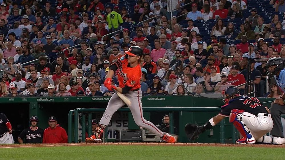
Gunnar Henderson clearly checking his swing, but goofball CB Bucknor behind the plate not asking for help and ringing him up for strike 3.
lol CB Bucknor behind the plate, not even asking for help down the line. good freakin grief, man.
24.04.2025 00:03 — 👍 4 🔁 0 💬 0 📌 0
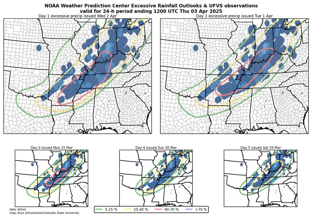
NOAA Weather Prediction Center Excessive Rainfall Outlooks all valid for 2-3 April 2025. The outlooks were very consistent in their location and the observed flooding occurred essentially right in the locations where the outlooks showed the highest probabilities.
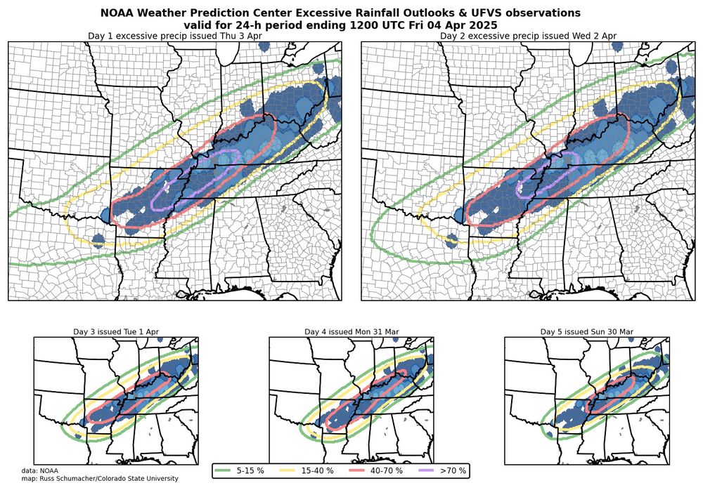
NOAA Weather Prediction Center Excessive Rainfall Outlooks all valid for 3-4 April 2025. The outlooks were very consistent in their location and the observed flooding occurred essentially right in the locations where the outlooks showed the highest probabilities.
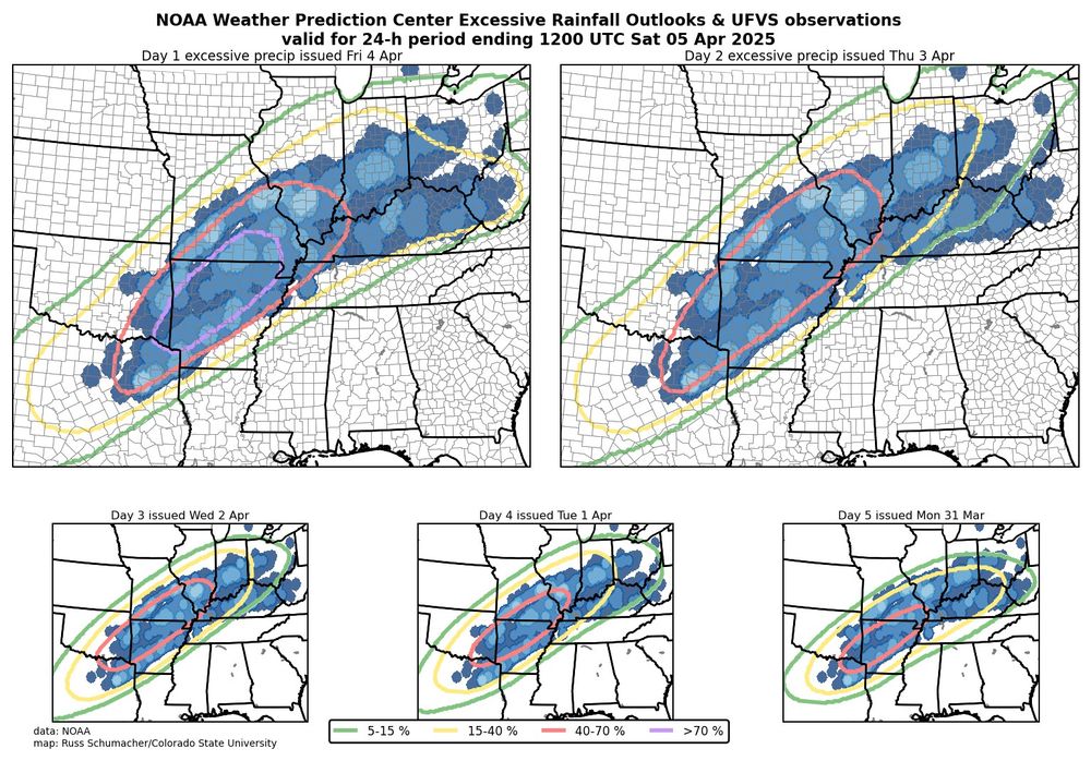
NOAA Weather Prediction Center Excessive Rainfall Outlooks all valid for 4-5 April 2025. The outlooks were very consistent in their location and the observed flooding occurred essentially right in the locations where the outlooks showed the highest probabilities.
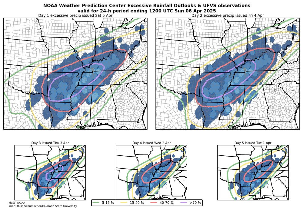
NOAA Weather Prediction Center Excessive Rainfall Outlooks all valid for 5-6 April 2025. The outlooks were very consistent in their location and the observed flooding occurred essentially right in the locations where the outlooks showed the highest probabilities.
We often (rightly) see maps like these showing how good SPC convective outlooks are; let's also give some kudos to WPC for some outstanding excessive rainfall outlooks for this event. Especially impressive are the day 5 outlooks, giving advance notice of prolonged excessive rainfall and flood risk.
06.04.2025 22:00 — 👍 92 🔁 30 💬 1 📌 0
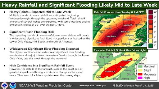
Sharing a WPC graphic regarding the incredibly concerning flood threat later this week.
01.04.2025 00:43 — 👍 32 🔁 24 💬 0 📌 3
$157 in mine 😳
31.03.2025 02:43 — 👍 1 🔁 0 💬 1 📌 0
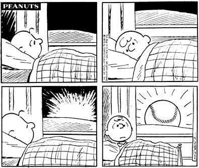
A screenshot of a Peanuts cartoon where Charlie Brown can't sleep and wakes up to a baseball sun
It's the most wonderful day of the year 😍
27.03.2025 10:05 — 👍 225 🔁 45 💬 6 📌 2
Washington Nationals Baseball ⚾
Nats Park, Presidents Race,
facts and sunlight too, when appropriate.
Let's kill Xitter.
Blog.letteddywin.com stopped in 2020 but still fun
(Scott Ableman)
The official squid of the washington nationals
Talking Washington Nationals and Washington Nationals prospects sans the crypto bots and well, you know. Welcome back if you followed me at the bad place.
Remember The Nats Report? We’re back on Bluesky. Help support us by becoming a member for just $5 a month or $30 a year:
https://www.thenatsreport.com/upgrade
stupidly sarcastic and unfunny Nats fan/lover of all things baseball. sous chef of sorts. likes include the ones you don’t like. stadium count: 19/30
Nats Baseball, Ret Music Teacher, Grew up overseas, word games, piano, dogs, all pets, Grandma (would you like to see pics?) Hot, black, coffee. Did I mention baseball? DC sports!
Cats, Critters, Books, Baseball, Wildlife Photography. Believer in Science.
News and notes on the Nationals minors since 2009
The illusion of a rebuild.
Nationals enjoyer. Subscribe to Waiting for Christian Garcia, my Nats newsletter! https://wfcg.substack.com/
Covering the Nationals ✍️ @washingtonpost.com
📧: spencer.nusbaum@washpost.com
Nationals reporter @washingtonpost | Northwestern ‘21👨🏾🎓 | @SJI_Update | Philippians 4:13 | Past: @chicagotribune @KCStar @baltimoresun | @NABJ | he/him
I answer to both first names — what you call me depends on how you know me. Editor, writer, insufferable know-it-all. Natitude, Hoya Saxa, AMDG.
Born like this, into this.
Things I love: Raising Nats Fans. Vandy. The 2019 World Series Champion Washington Nationals. Hugs. Smiles. One Braves fan. Kindness. Looking on the bright side
Retired & loving it! Nationals cranklet. Duuuval! (It’s a long story) Go Caps! Does anybody really know what time it is? I sure don’t. 1A absolutist. Engel v. Vitale is the hill I will die on. @edit_susan on the hellsite, 4 now. No DMs if I don't know you
Believer in equal education for all children, the hope for tomorrow.
‘We won’t go back’ as a motto is great. I am old enough to have rejoiced in ‘73.
Supporter and longtime usher for the Washington Nationals, now at George Mason for sports and arts too
Crazy about the Washington Nationals, corgis, and democracy!
When i started my twitter accout, i was a dark meat hook.
When i started my bluesky account, i was Employee 11
MLB: 21/30 (26)
NBA: 9/30 (10)
NHL: 9/32 (11)
NFL: 7/32
States: 35/50