This lasts a surprisingly long time
01.11.2025 03:31 — 👍 1 🔁 0 💬 1 📌 0

a colorful gouache painting of a female belted kingfisher with a colorful abstract starry background. There is a crescent moon behind it and its holding a star in its beak
Queenfisher 🪶
6x6" Gouache on Watercolor Paper
Art from my time up at the cabin in September, I really want to do more birds like this :)
27.10.2025 16:41 — 👍 195 🔁 63 💬 5 📌 1
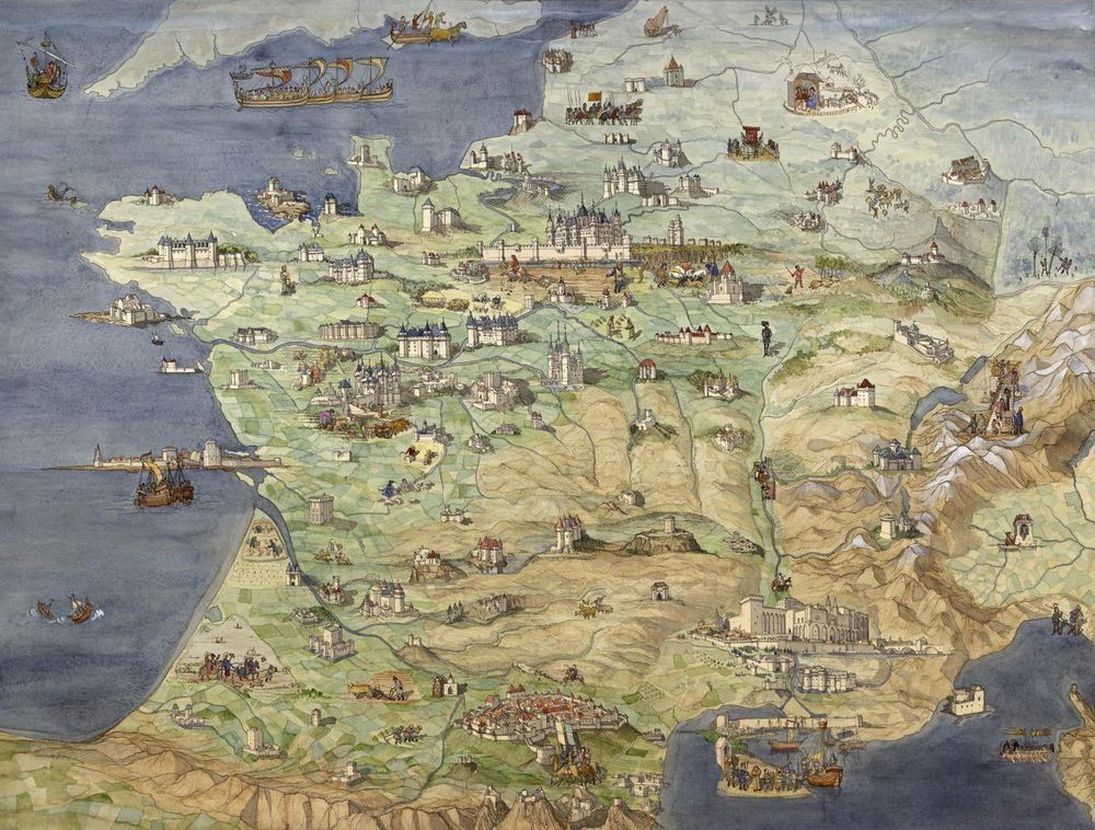
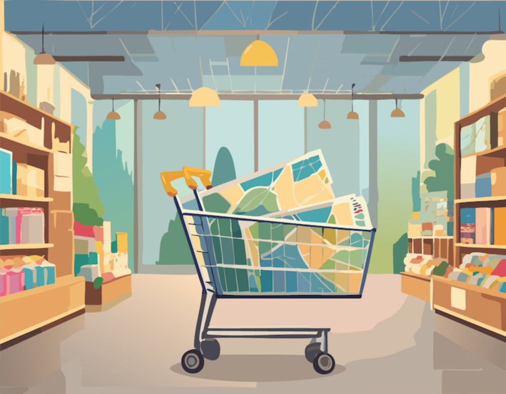
Lovely map of French castles by Jean-Claude Golvin. Which one to visit first?
07.10.2025 18:03 — 👍 49 🔁 12 💬 1 📌 0
#KPopDemonHunters #PopVsSoda
11.09.2025 20:30 — 👍 7 🔁 4 💬 0 📌 1

Cincinnati in 50 Maps
Edited by Nick Swartsell with cartography by Andy Woodruff Publication date: December 2, 2025 There are as many versions of Greater Cincinnati as there are residents of the region. That’s roughly tw...
Cincinnati in 50 Maps, by Nick Swartsell and me, is off to the printer, so you can get your pre-orders in now for the December launch! beltpublishing.com/products/cin...
Get this, folks: I counted and there are 125 individual maps. That's 75 extra maps for free!
04.09.2025 14:16 — 👍 31 🔁 10 💬 0 📌 1
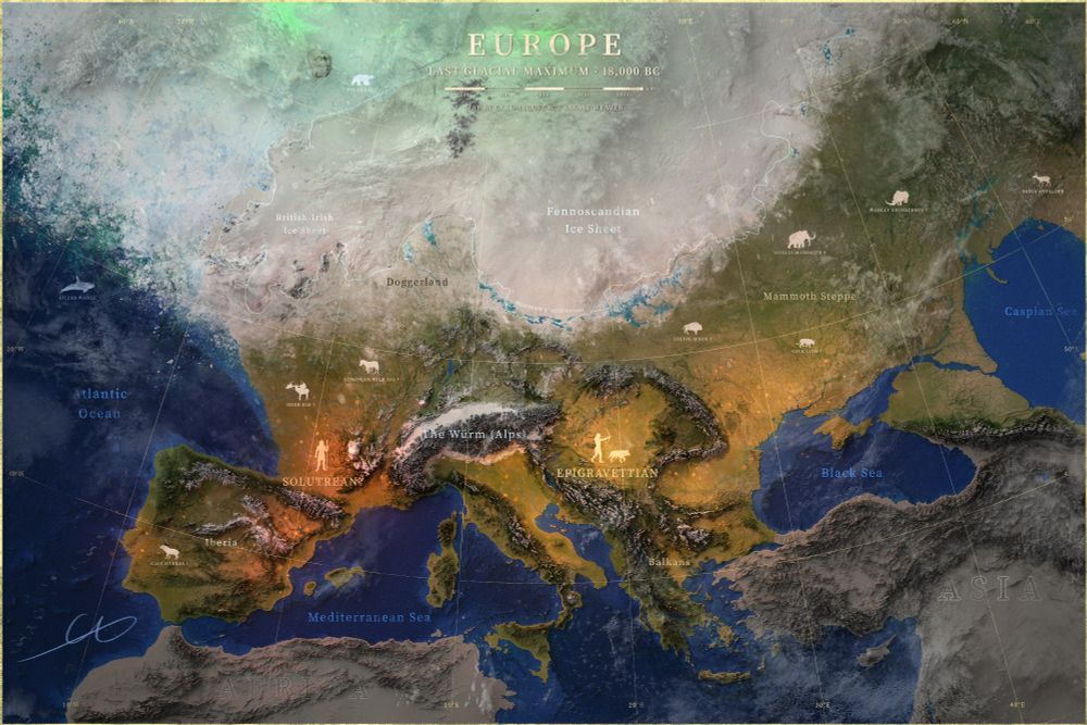
Map of Europe during the most recent Ice Age (the last glacial maximum) - 20,000 years ago.
Made with ArcGIS, Photoshop, Illustrator & Blender. Raw image is roughly 12K in size. #geology #paleoart #sciart #GIS #maps ( #PrehistoricPlanet !!whoo)
30.07.2025 19:42 — 👍 165 🔁 47 💬 2 📌 1

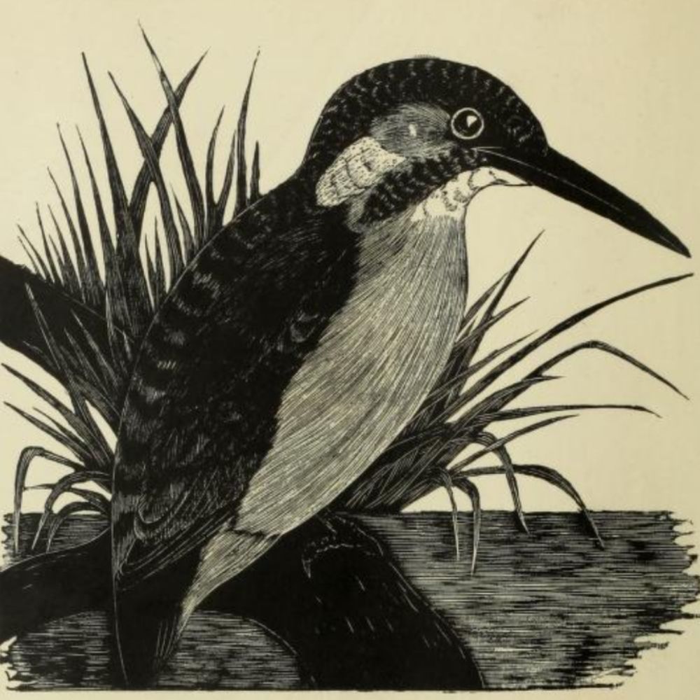
Kingfisher hunting for fish in the water
Ohara Koson (1877-1945)
28.07.2025 15:23 — 👍 28 🔁 9 💬 0 📌 0

Plotting distributions. 16 different ways to visualize one data set.
The list is by no means exhaustive, HOPs, horizon charts and I'm sure other charts can be and have been used to show distributions. But attached is a handy one pager to summarize all the methods discussed here
16.07.2025 13:19 — 👍 10 🔁 1 💬 1 📌 1
YOOOO my talk at @nacis.bsky.social has been accepted and it looks like I'll be making 2025 a Triple Conference Year.
Folks are so curious about The Map Center and I honestly love telling the story over and over and over again. See you in Louisville!
12.07.2025 23:39 — 👍 76 🔁 5 💬 2 📌 0
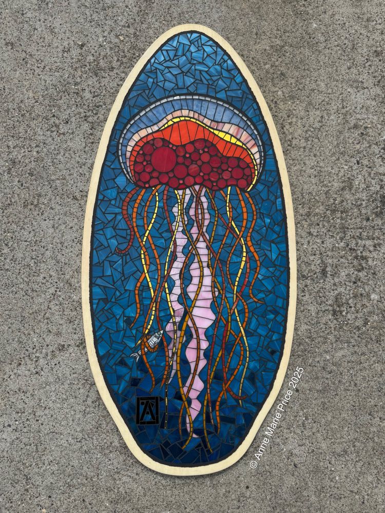
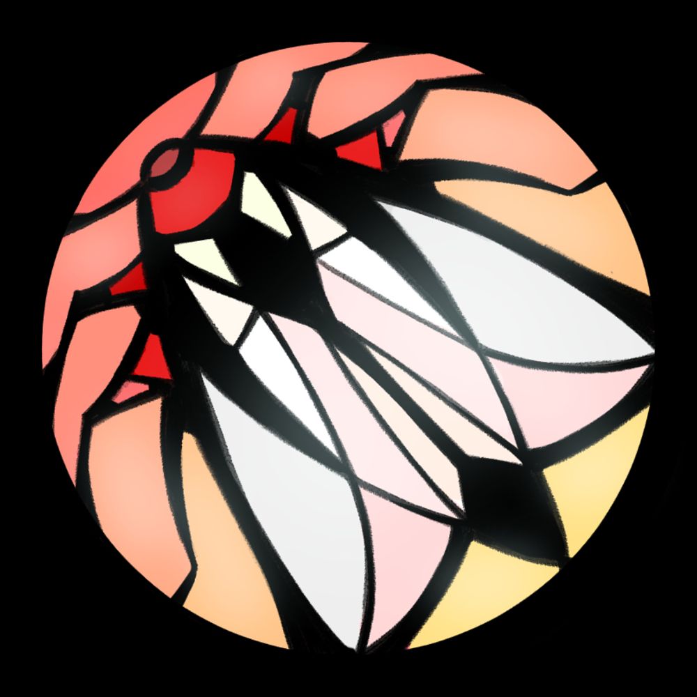
Stained glass mosaic of a jellyfish with fish caught in a tentacle on an upcycled wood skim board.
Finished!
“Jellyfish”
20” x 41 1/2”
Stained glass all careful cut by hand and lovingly adhered to an upcycled wood skimboard. Ready to hang on a wall.
(Available for purchase.)
#mosaic #art #annemarieprice
12.07.2025 02:14 — 👍 55 🔁 10 💬 8 📌 1
The fun part is, the geography of the city is such that the national park is the only place with any elevation, so it's a one to one mapping of contours and park and nothing else
19.06.2025 00:15 — 👍 1 🔁 0 💬 0 📌 0
Thanks for the flag. Reposted
18.06.2025 02:03 — 👍 0 🔁 0 💬 0 📌 0

Typographic map of Chiang Mai, Thailand done in English and Thai
Finished a several year long project - a Axis Maps style typographic map of Chiang Mai, Thailand. Done in both English and Thai.
18.06.2025 02:03 — 👍 20 🔁 4 💬 1 📌 1

detail of map scraps sewn together in a radial star-shaped pattern

detail of a grid of collaged map scraps sewn together
Cutting apart old maps, discontinued currency, and flags, Faith XLVII sews them back together into patterned tapestries.
www.thisiscolossal.com/2025/06/fait...
17.06.2025 18:50 — 👍 48 🔁 8 💬 0 📌 0

The Wisconsin cartographer who mapped Tolkien’s fantasy world
Rob Ferrett and Beatrice Lawrence from WPR's "Wisconsin Today" went to see Karen Wynn Fonstad’s original hand-drawn maps in-person.
Karen Wynn Fonstad, was a Wisconsin cartographer who created dozens of maps that went into "The Atlas of Middle-earth," the official geographic guide to the worlds of author J.R.R. Tolkien: "The Hobbit" and The Lord of the Rings."
A new quest: to digitize her original maps, and find an archive.
12.04.2025 19:06 — 👍 36 🔁 14 💬 2 📌 0
The 2025 NACIS Annual Meeting will be in Louisville, KY, Oct 15-18! We invite you to submit abstract proposals for presentations in the Main Conference or Practical Cartography Day or to organize specialty themed sessions, discussion panels, workshops and field trips. Submissions due May 15, 2025.
02.04.2025 00:38 — 👍 17 🔁 12 💬 1 📌 0

Wemby playing Chess in Washington Square Park
The Seventh Seal, directed by Ingmar Bergman, 1957, 📸 of @wemby by @johnhateclub
28.12.2024 16:26 — 👍 3120 🔁 445 💬 18 📌 26

I randomly found it, but W.E.B. Du Bois once provided a pronunciation guide to his last name (per the Du Bois Freedom Center)
14.12.2024 17:24 — 👍 7 🔁 1 💬 0 📌 1
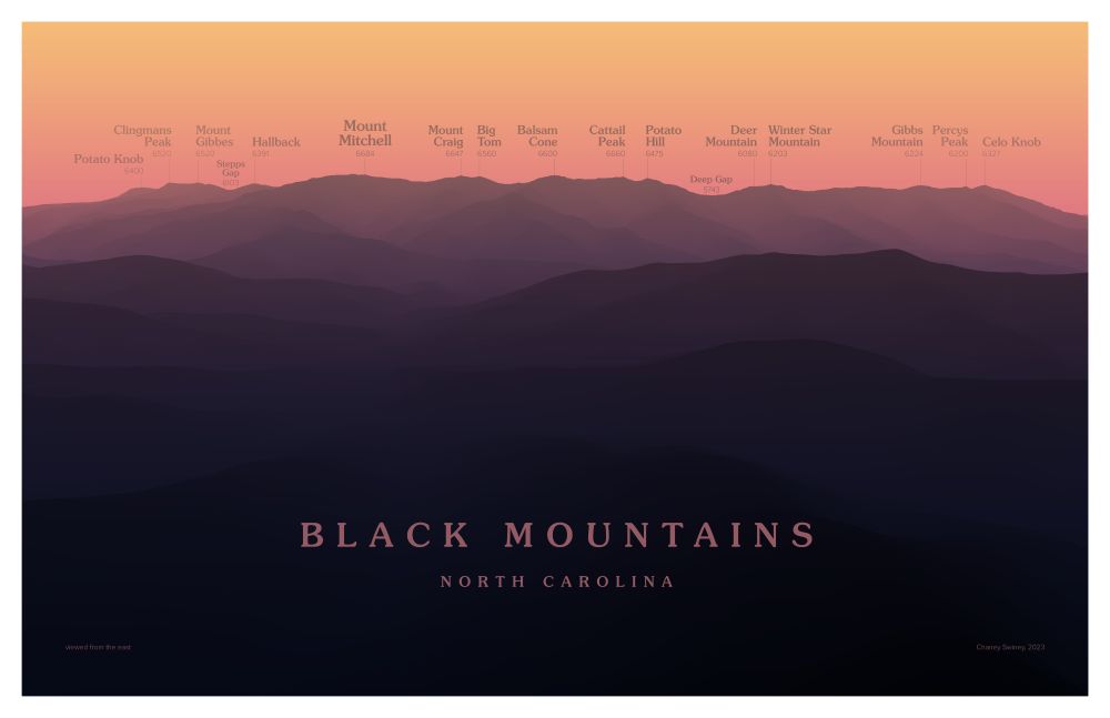
Image of the Black Mountains in North Carolina, cast in a gradient reminiscent of sunset hues: orange at the top to dark purple at the bottom. Summits are labeled with their names and elevations.
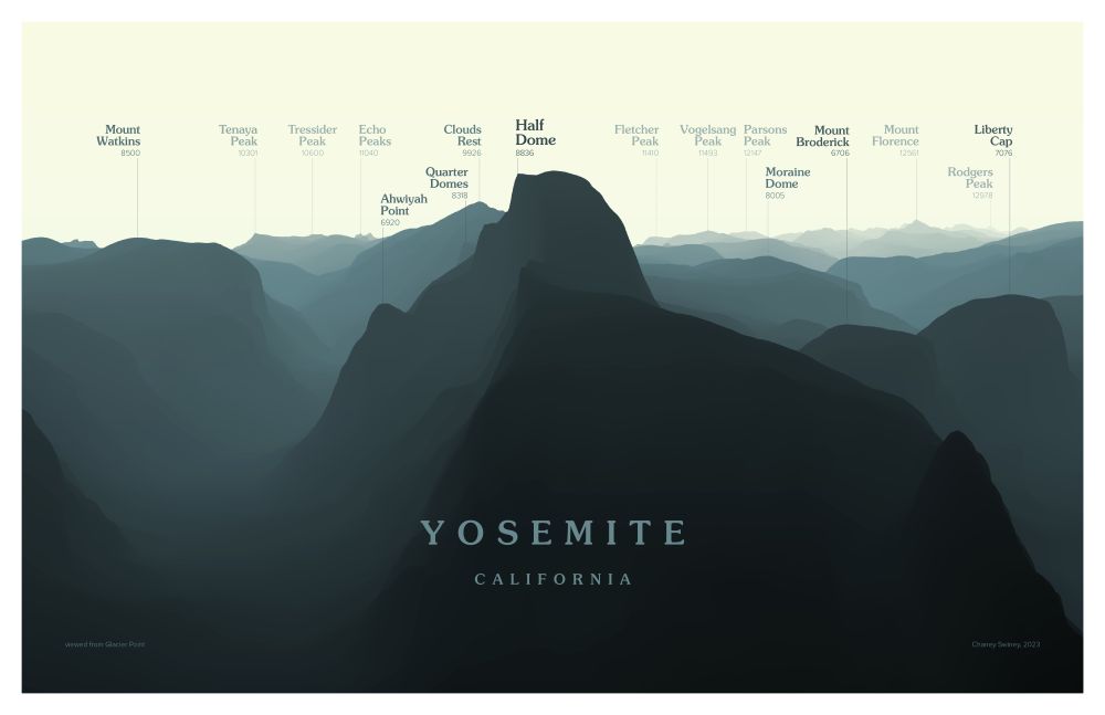
Image of Half Dome and its surroundings in Yosemite National Park, cast in a gradient of yellowish blue. Summits are labeled with their names and elevations.
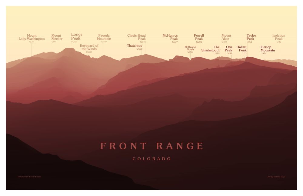
Image of the Front Range in Rocky Mountain National Park, cast in a gradient of yellow to red. Summits are labeled with their names and elevations.
A favorite recent project: Peakscapes. I love the layered looks you get in the #mountains, and I always want to be able to name everything in view. These designs provide a cleaner, more idealized view of the landscape than a photo can.
Are they #maps? Or geographic art? I'm not sure.
05.12.2024 15:48 — 👍 81 🔁 20 💬 5 📌 2

#30DayMapChallenge Jour28/ Day28 - Planète bleue / Bonne journée de la Méditerranée
28.11.2024 16:59 — 👍 143 🔁 53 💬 3 📌 10

Map of the world in the Fuller projection. Made with black oceans, gray land, and gold projection borders and gold lat/long lines.
Day 26 of the #30DayMapChallenge - Projections
I made this for @pinakographos.bsky.social projections card set. Such a great project.
27.11.2024 22:41 — 👍 12 🔁 1 💬 0 📌 0
Independent Map Sellers
A shopping guide offered by the Independent Map Artists
The Independent Map Artists now has a website: mapartists.org!
It's a hub for you to find all sorts of posters, shirts, and other gifts for the map nerds in your life.
Many of us sell in our own small shops, but we're stronger together. Spread the word!
19.11.2024 20:21 — 👍 82 🔁 35 💬 4 📌 9

A basketball that is also a globe, displayed on a shelf. The globe features political boundaries and labels, and a prominent blue ocean bathymetry.
Here’s a recent-ish thing that I didn’t post here at the time: I helped Kirk Goldsberry design this globe basketball, puzzling through map projections to get something close to matching each of the eight segments on the ball. A bit more about it here: andywoodruff.com/posts/2024/a...
18.11.2024 15:37 — 👍 36 🔁 4 💬 2 📌 2
I was given the nickname Kingfisher while working in Burma. I had been doing some life guarding on a white water river and the orange hair jumping into the river to grab people was an obvious inspiration. 😂
16.11.2024 20:08 — 👍 1 🔁 0 💬 1 📌 0
Wendy Shijia is wizarding again.
"Experimenting with the #DeepPaint addon in #Blender to 'paint' a landscape - coloring a 3D model of landscape generated from USGS lidar point cloud data."
www.linkedin.com/posts/wendys...
14.11.2024 18:43 — 👍 31 🔁 4 💬 0 📌 0

a basketball that is also a globe
This is art.
03.11.2024 23:57 — 👍 16 🔁 2 💬 1 📌 0

CP3 and Wemby
Marie-Thérèse, Face and Profile, by Pablo Picasso, 1931, 📸 by @reginaldthomas
-
Reginald is one of my absolute favorite hoops photographers - truly embracing Sports & Art - and I strongly encourage you to check out his work (@reginaldthomas on instagram - link isn’t working for some reason)
09.11.2024 16:35 — 👍 643 🔁 65 💬 2 📌 2

A blackout poem made using the OSM Street map of the Tacoma area
#30DayMapChallenge | Day 5 | Journey
A poem I made for the @nacis.bsky.social map quilt.
A Journey Of Celebration
Mountain Maple
an Old Bonsai
Children
A Valley Sunrise
Gethseman
A Bent Tree
The Birch, Alder, & Juniper
a Common Truth
05.11.2024 19:12 — 👍 5 🔁 0 💬 0 📌 0
UK freelance illustrator and concept artist based in Wales
https://linktr.ee/aledthompsonart
Constructivist caricatures and graphic illustration ✨ ella/she/her
http://www.mariapicasso.com/linktree
Writer. Reader. Sometimes funny. Generalized anxiety Wunderkind. Author of “Winterset Hollow.” https://jonathanedwarddurham.substack.com
http://Patreon.com/jonathanedwarddurham
https://jonathanedwarddurham.com
Illustrator, writer and art director. Children's books, graphic novels and other things.
Website: https://artbyjulianguy.com/
flat fantasy and rpg illustration by some queer in the hills of western NC
commissions open - shaferbrownillus@gmail.com
portfolio: shaferbrown.com
tipjar: patreon.com/shaferbrown
The most online former A-10 basketball player. Current adult dad. Burlington Coat Factory influencer. My only character flaw is that I love the Boston Celtics.
Passive Depressive Scary Muppet
Artist, TTRPG lover.
World of Darkness (VtM, CtD, HtR), Dungeons and Dragons, Kult: Divinity Lost
sionskaia.carrd.co
| 🌈 | (he-him) TTRPG ilustrador and fantasy cartographer. Brazilian. ND.
🗺️ https://www.patreon.com/tomeofsalvaterra
#cartography #art #ttrpg
🚫NoAI/N-F-T
💼 https://cara.app/salvaterra
☕ https://ko-fi.com/salvaterra/shop
📧diariodecampanharpg@gmail.com
Freelance Illustrator, Tarot of the Divine Creator
Working on an Oracle Deck
📧 yoshi@yoshiyoshitani.com
Literary Agent: Thao Le at Sandra Dijkstra Literary Agency
Shop & Links yoshiyoshitani.com/click-me
Using #tarot #oracledeck #art
Check Art Only Feed
Pés na terra e asas na mão | Freelance Illustrator from Portugal 🇵🇹 | she/her | https://linktr.ee/eleonorpiteira | FaB & MtG art | Clients: Digital Extremes, Del Rey, Tor, Orbit
✨ https://eleonorpiteira.squarespace.com/
No NF/Ts, No A/I 'art'
Illustrator ✨ she/her ✨
Portfolio: https://marissasketch.carrd.co
Prints: https://inprnt.com/gallery/marissasketch
Ko-fi: https://ko-fi.com/marissasketch
Fine artist of Imaginative Realism. Retired illustrator of Science Fiction and Fantasy. Winner of 15 Hugo Awards. Inducted into the SF Hall of Fame in 2009.
Cartographer, data visualizer, beans on toast defender.
helenmakesmaps.com for tutorials
Fantasy Artist, Watercolour - MTG, Gwelf 🇨🇦
Menswear writer. Editor at Put This On. Words at The New York Times, The Washington Post, The Financial Times, Esquire, and Mr. Porter.
If you have a style question, search:
https://dieworkwear.com/ | https://putthison.com/start-here/
a failed art account 22 A dude. I do sell prints, please DO NOT contact me about nft stuff thanks. alariko771@gmail.com
Illustrator
■Mail→ asakivision@gmail.com
■ArtStation→https://asaki_vision.artstation.com/
■Skeb→ http://skeb.jp/@asakivision ■FANBOX→ http://asakivision.fanbox.cc
Hand-picked lines from the 1979 Book of Common Prayer, tweeted in random order. A bot by @hapax.bsky.social, powered by @bluebotsdonequick.com.
join the zillionaires 🏡. Send me wild homes: zillowgonewild.beehiiv.com