Cover illustration for Earth Observation, an open-access EGU journal: a stylized purple globe with satellites, aircraft, drones, radar dishes, and observatories monitoring Earth, with EGU and Copernicus Publications logos.
Launch of a brand new @egu.eu journal called Earth Observation. Fully open access, publicly peer reviewed and edited by leading experts in ther field. Check out the scope, editors and options.
www.earth-observation.net/home.html #openaccess #noprofit #earthobservation 🌍🛰️📡🌊🧊
19.01.2026 17:48 —
👍 36
🔁 18
💬 1
📌 1
🚀 And finally, #TerriaJS's Ana Belgun's thought provoking closing keynote: reframing barriers to business/government uptake of open source (security, compliance) as genuine opportunities for the field. A powerful way to end the week!
A huge thanks to all the @foss4g.org organisers and volunteers! 🙏
21.11.2025 09:34 —
👍 2
🔁 0
💬 0
📌 0
🗺️ As always, @nyalldawson.net and Mathieu Pellerin's QGIS workshop was mind-blowing. So many amazing tips/tricks/tools hidden in plain sight!
⚙️ It was incredible to hear how NZ's #LINZ is moving to a modern architecture built entirely on cloud native geospatial, open source and in-house expertise.
21.11.2025 09:30 —
👍 0
🔁 0
💬 1
📌 0
🧙 @geoskeptic.bsky.social's interactive #STAC Field Guide / Choose Your Own Adventure talk was one of the most fun presentations I've seen! It's incredible how ubiquitous (and essential) STAC has become to geospatial.
21.11.2025 09:30 —
👍 0
🔁 0
💬 1
📌 0
🛢️ #Zarr format (i.e. cloud friendly multidimensional arrays) seems finally poised on the cusp of widespread operational use, with huge momentum building around both the format itself and the ecosystem around it. @esa.int's #EOPF program to deliver Sentinel data in Zarr is particularly exciting!
21.11.2025 09:30 —
👍 0
🔁 0
💬 1
📌 0

Photographs from FOSS4G conference, showing attendees and events

Photographs from FOSS4G conference, showing attendees and events

Photographs from FOSS4G conference, showing attendees and events

Photographs from FOSS4G conference, showing attendees and events
Had an amazing time presenting our #eotides Python package at the global #FOSS4G conference in Auckland, NZ. Thanks for all the fascinating chats after the talk - it was genuinely inspiring to discover just how much the Venn diagram of #opensource + #coastal overlap! 🌊🤝🧑💻
Some top takeaways below! 👇
21.11.2025 09:30 —
👍 6
🔁 0
💬 1
📌 0
Stinky, but incredible habitat and feeding grounds for so many different species - especially all the endangered birds that feed there as are they migrate halfway across the world every year!
17.11.2025 09:07 —
👍 1
🔁 0
💬 0
📌 0


Mōrena, Good morning ☀️
Day 1!
FOSS4G 2025 is finally here!
We are full of smiles to welcome you to this year's global conference and to Tāmaki Makaurau, Auckland, NZ.
Look out for our signs when you arrive at Auckland University of Technology.
#osgeo #foss4g
16.11.2025 21:27 —
👍 7
🔁 4
💬 0
📌 1

Elevation map of the intertidal zone in Auckland

Photograph of the intertidal zone in Auckland

Photograph of the intertidal zone in Auckland
✈️ Flying into NZ for #FOSS4G @foss4g.org - couldn't help but nerd out on all the beautiful tidal flats that surround Auckland.
Here's a quick #DEAIntertidal tidal flat elevation map of Auckland’s Manukau Harbour, generated using #opensource code + satellite data loaded via #OpenDataCube and #STAC!
16.11.2025 23:45 —
👍 7
🔁 1
💬 1
📌 0

Registration poster for AusYCSEC
Last chance to register for free online attendance at the #AusYCSEC Young Coastal Scientists & Engineers Conference!
Come along to hear lots of exciting coastal research happening across Australasia... plus a special new data announcement from Geoscience Aus in the opening session! 🤩🌊📷🛰️
24.09.2025 07:29 —
👍 3
🔁 3
💬 1
📌 0
Following up on this, here's an even cooler animation of the SWOT overpass!
earthobservatory.nasa.gov/images/15466...
18.08.2025 21:59 —
👍 28
🔁 9
💬 0
📌 1
Happy National Science Week! 🎉 From the coast to the deep sea, IMOS Facilities like Acoustic Telemetry and Argo Floats are providing vital data to understand and protect marine life and ecosystems in a changing climate. Learn more 🔗 bit.ly/4mxjNVk
#NationalScienceWeek2025 #NCRISImpact
09.08.2025 00:01 —
👍 9
🔁 2
💬 0
📌 0
Hey cool--this is one of the satellites I regularly bounce a laser off of. Nice to contribute to missions like this. :)
08.08.2025 17:48 —
👍 26
🔁 3
💬 0
📌 0

Mosaic of desert fires, salt lakes and dunes. Great sandy desert Western Australia.
07.08.2025 22:21 —
👍 7
🔁 2
💬 0
📌 0

Understanding flood detection models across Sentinel-1 and Sentinel-2 modalities and benchmark datasets
In recent years, research in flood mapping from remote sensing satellite imagery has predominantly focused on deep learning methods. While new flood s…
👉New paper: "Understanding #flood detection models across Sentinel-1 and Sentinel-2 modalities and benchmark datasets"
🌊This study presents a model generalization across different regions & satellite sensors.
📄 tr.ee/Understandin...
💻Code & models: github.com/kipoju/udl4fl
#RemoteSensing
07.08.2025 08:30 —
👍 5
🔁 1
💬 1
📌 0

How do we track water flowing through rivers from space? This major review says: 1–3 day revisit. Resolution down to 30–100 m widths. Must include width, slope, & velocity. Flood forecasting + water management depend on it. #EarthObservation #RemoteSensing #WaterResources doi.org/10.1029/2024...
07.08.2025 13:17 —
👍 7
🔁 4
💬 0
📌 0
Fair play to #foss4guk 2025: I will be giving a presentation called "Remote Sensing Sucks". I have my opinions, but what gets you worked up about modern EO and RS? It could be anything at all. Let me know and I might reference it in the slides :-) #earthobservation #geospatial #gis #rssucks
02.08.2025 10:42 —
👍 2
🔁 1
💬 3
📌 0
IGARSS 2025 || Brisbane, Australia || 3 - 8 August 2025
I'm giving a talk on Thurs about our work to improve tide modelling across Australia's remote and challenging coastlines. I'll also be around the Geoscience Australia booth if anyone wants to drop by and nerd out on coastal satellite remote sensing!
www.2025.ieeeigarss.org/view_paper.p...
03.08.2025 23:17 —
👍 3
🔁 1
💬 0
📌 0

Photograph of IGARSS opening ceremony
Wonderful to be at #IGARSS2025 in Brisbane! 🛰️Hopefully a nice Take 2 from my first IGARSS in Pasedena, CA where I spent half of the conference locked up in COVID hotel quarantine!
03.08.2025 23:17 —
👍 10
🔁 1
💬 1
📌 0
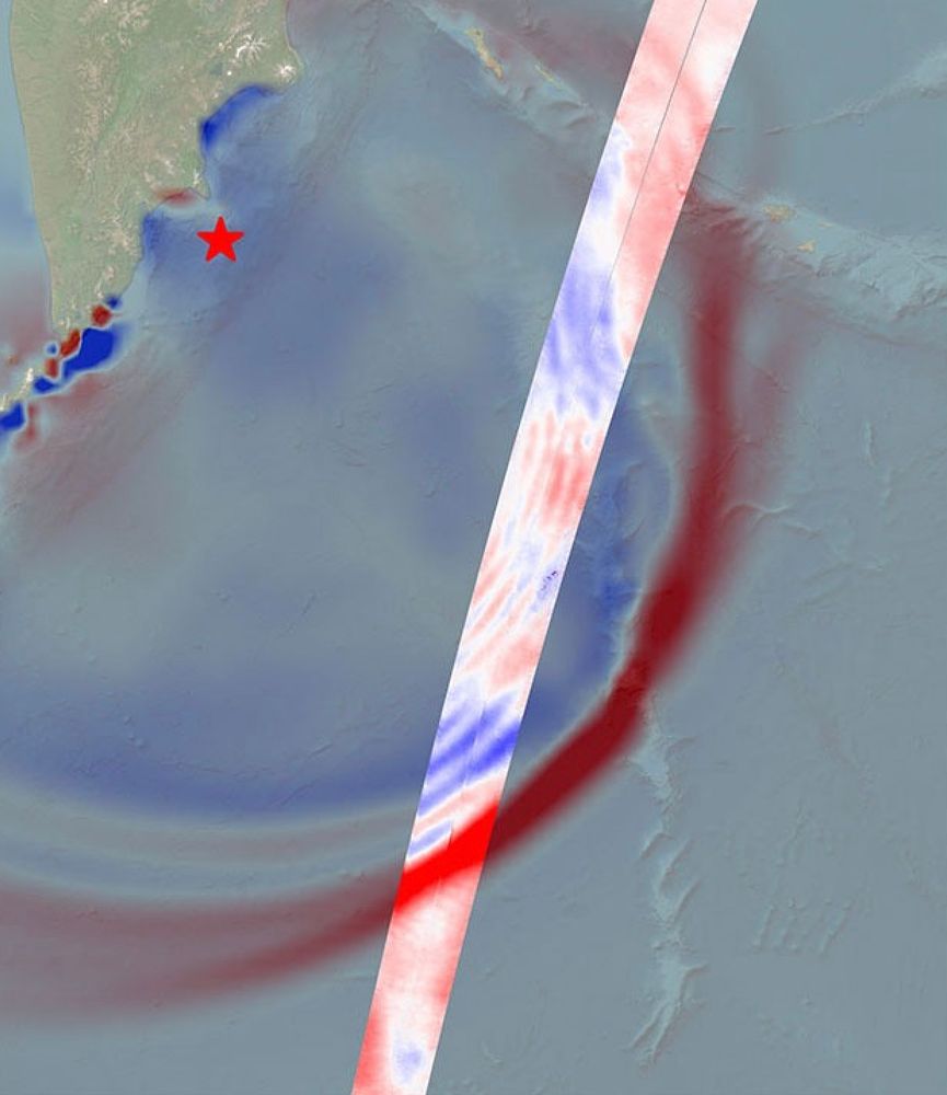
🛰️ As many in the Earth community know, NASA's Terra and Aqua satellites are soon to be decommissioned because they are past their designed life. Part of the process involves changing their orbits thus their overpass time. go.nasa.gov/44X3QSk 1/3
01.08.2025 21:46 —
👍 15
🔁 6
💬 1
📌 1


☁️ Clouds in the spotlight at #LPS2025!
The Algorithm Intercomparison Exercises session is on—an essential part of EO processing.
Jan Wevers presents our work on CMIX-II, the ESA–NASA initiative comparing cloud detection methods for 10–30 m sensors.
#CMIX #EOAlgorithms #CloudMasking #EarthObservation
26.06.2025 09:01 —
👍 4
🔁 2
💬 0
📌 1
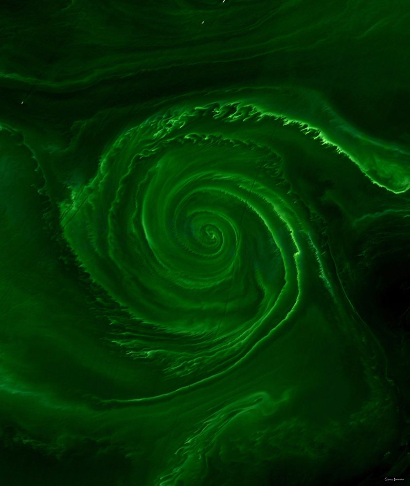
Algal vortex in The Baltic Sea.
Image taken by Landsat-8 on July 18, 2018.
27.06.2025 18:26 —
👍 119
🔁 36
💬 2
📌 1
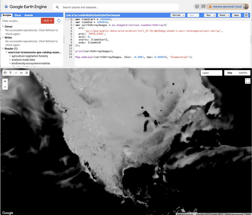
The Google Earth Engine code editor displaying an evaporation map loaded directly from ARCO-ERA5! The black and white map overlooks the continental US. It's easy to make out land masses, but there are also cloud-looking visuals on the map.
I've been waiting a few years for this: Zarr v2 support was just launched in Google Earth Engine! Check out this demo that loads ARCO-ERA5 into GEE 🔥
code.earthengine.google.com/67ac1e48848d...
developers.google.com/earth-engine...
27.06.2025 19:28 —
👍 16
🔁 4
💬 1
📌 2
Beneath the canopy: Pioneering satellite reveals rainforests' hidden worlds - BBC News
First groundbreaking images from the Biomass satellite could change our understanding of rainforests
Had an amazing time at #LPS25 this week, where @esaearth.esa.int unveiled the first images from the Biomass satellite.
Read our story with @esmestallard.bsky.social and see the stunning new images for yourself:
28.06.2025 07:39 —
👍 30
🔁 11
💬 2
📌 1
These are old archived posts - I did a big all of time copy when I moved over from there a few months ago 🙂
27.06.2025 23:30 —
👍 1
🔁 0
💬 0
📌 0

A screenshot of the slides

A screenshot of the slides

A screenshot of the slides
Recently, I taught a session on landscape metrics in R—covering how to quantify spatial patterns in landscapes. 🌾📊
Slides + exercises here:
🔗 jakubnowosad.com/rgis2025/out...
#rGIS2025 #rstats #LandscapeMetrics #GIS #rspatial
06.04.2025 14:00 —
👍 35
🔁 8
💬 3
📌 0