Glad you made it through. My mom in her was not so lucky a couple of years ago. After her week-long bout with confusing encephalitis, she was diagnosed with Powassan from a tick. She lived in RI in the US where ticks are very common but Powassan is rare. Stay aware and treat your pets for ticks!
07.04.2025 15:27 — 👍 0 🔁 0 💬 0 📌 0

Hands off protest in Boston
Great #handsoff turnout in Boston!
05.04.2025 18:30 — 👍 3 🔁 0 💬 0 📌 0
This is so low. Maine Sea Grant apparently just got shut down to punish the governor. #thishastostop
01.03.2025 20:44 — 👍 2 🔁 0 💬 0 📌 0
New USGS hires at our lab just got termination letters. Horrible for our research but truly devastating for them.
#executiveoverreach
14.02.2025 21:21 — 👍 2 🔁 0 💬 2 📌 0
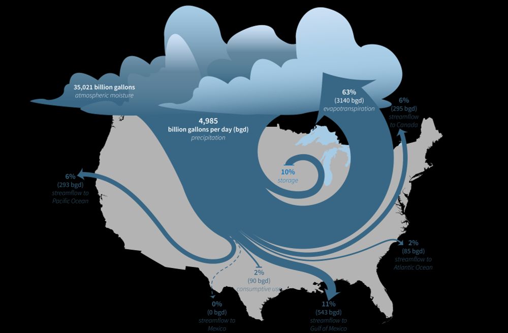
Stylized illustration of the water cycle of the lower 48 United States, showing the fate of water that enters through precipitation. Most of the water returns to the atmosphere through evapotranspiration, but much of the water ends up in the Atlantic and Pacific Oceans, in Canada, or in the Gulf of Mexico through streamflow.
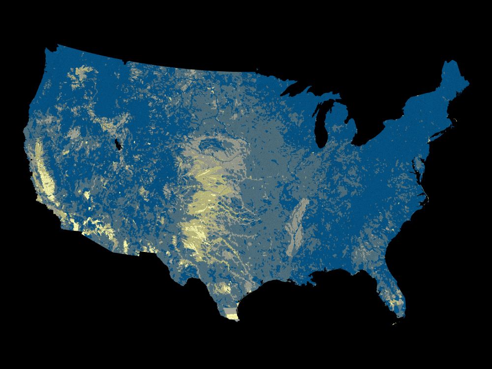
Map of water limitation in the lower 48 United States by watershed. Areas with relatively high water limitation are in the high plains, Texas, California, and the Mississippi Embayment hydrologic regions.
The U.S. Geological Survey (USGS) Vizlab has just released a new, interactive data visualization website about the USGS National Water Availability Assessment Report and Data Companion. Explore the data and the key findings of the assessment at water.usgs.gov/vizlab/water... #DataViz #rstats #USGS
16.01.2025 18:20 — 👍 22 🔁 10 💬 1 📌 2
A great step towards dynamic scientific articles.
[I thought his voice was familiar - he also did that great video on how to make an effective scientific poster that I gave to all my students]
16.01.2025 16:34 — 👍 3 🔁 1 💬 1 📌 0
I love the things we see in streams in the Flow Photo Explorer www.usgs.gov/apps/ecoshed.... Here, in Nevada, a tumbleweed hangs around from Feb to May, finally getting pushed out by some high flow. In case you were wondering, it showed up between 11:15 and 11:30 pm on Feb 4 :)
#flowphotoexplorer
12.12.2024 14:10 — 👍 3 🔁 0 💬 0 📌 1

Barred owl sitting on stump.
With hundreds of cameras and millions of photos in our Flow Photos Explorer, we get some cool wildlife pix (screened by megadetector). See the owl?
Nerd alert - we can also tell you within 15 min when the tree top of the stump the owl is sitting on fell. That's got to be valuable to someone, right?
27.11.2024 20:45 — 👍 5 🔁 0 💬 0 📌 0
I would appreciate an add - thanks!
25.11.2024 14:16 — 👍 1 🔁 0 💬 1 📌 0
Here's one that is on the Texas border :) www.usgs.gov/apps/ecoshed... -really dynamic river. Anyone can set up a pretty cheap trail camera and upload images! Here's the user guide to get started: www.usgs.gov/apps/ecoshed...
25.11.2024 13:55 — 👍 1 🔁 0 💬 1 📌 0
Hi, small fish in small streams here. Thanks!
22.11.2024 02:32 — 👍 0 🔁 0 💬 1 📌 0
And here are 3 streams in Shenandoah NP during hurricane Helene - yikes!
22.11.2024 00:15 — 👍 4 🔁 2 💬 0 📌 0
What happens to small streams during a hurricane? Here are time-lapse photos (every 15 min) from our Flow Photos Explorer of 3 sites in PA during Helene. Shocking how high they get and that any fish can survive. They are so flashy, we might even have missed the peak. [gif by Phillip Goodling]
22.11.2024 00:12 — 👍 1 🔁 1 💬 0 📌 0

Number image is increasing exponentially
The number of images in our Flow Photo Explorer is going up, up, up! It uses trail cameras and machine learning to estimate stream flow, especially in small streams. Anyone can use it!
Check it out: www.usgs.gov/apps/ecoshed...
21.11.2024 18:28 — 👍 5 🔁 1 💬 1 📌 1
I would appreciate an add, thanks! Lots of work in small streams...
21.11.2024 17:00 — 👍 1 🔁 0 💬 0 📌 0
Demographics | Geospatial | Data Science | Open Source
I study diversification, species delimitation, trait evolution & similar questions, often using new methods. Also random coding projects. College prof living in Oak Ridge, TN, USA. Opinions my own. He/Him
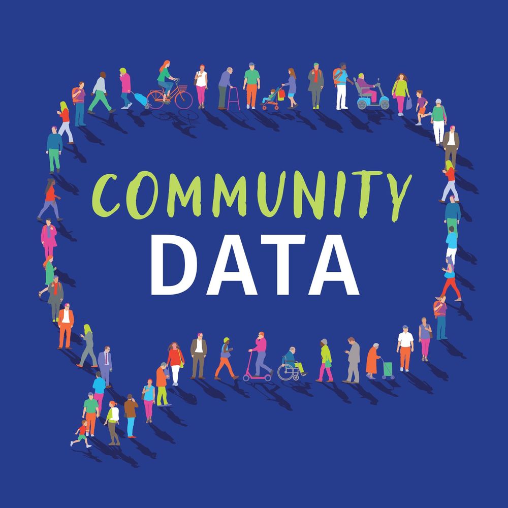
Science graphics at NY Times
Creative data & computational journalism. "Community Data" book eBook and pre-order available: http://communitydatabook.com
Evolutionary ecologist and conservation biologist with an affinity for freshwater and anadromous fish. Postdoc at UC Berkeley.
Associate Professor at UW SAFS 🐟
applied ecology 📈 aquatic ecology 💦
(he | him)
https://fish.uw.edu/faculty/mark-scheuerell/
Writer, journalist. Science, health. Pandemics, animals. Birder, photographer. Many words, some awards. AN IMMENSE WORLD, I CONTAIN MULTITUDES. Married to Liz Neeley, parent to Typo. he/him
📷 Canon R6mkii + RF 800mm
Edyong.me
Columnist and chief data reporter the Financial Times | Stories, stats & scatterplots | john.burn-murdoch@ft.com
📝 ft.com/jbm
Fueling web creativity since 2009. Free #frontend tutorials, inspiration and creative demos. https://www.codrops.com
Senior data producer, CBC/Radio-Canada. Behind https://github.com/nshiab/simple-data-analysis and https://code-like-a-journalist.com/. More on https://naelshiab.com/.
Supah • I do tricks with pixels since 1999 • Creative dev @ studiogusto #webgl #shaders #threejs #glsl #javascript #react #canvas
https://supah.it
https://linktr.ee/supahfunk
The lighter side of science 🚀🧪🔭🧬 For more: https://sked.link/iflscience
Owner of MSW Media, host of The Daily Beans, UnJustified, and Cleanup on Aisle 45 podcasts. #Leguminati. Veteran. She/Her Substack: muellershewrote.com Secure contact: FedOath@pm.me
Signal: muellershewrote.23
Podcast: https://link.chtbl.com/TheDailyBeans
Mondays at 9pmET on MSNBC
MaddowBlog.com
Andrew Young: The Dirty Work: MSNBC.com/Andrew-Young-The-Dirty-Work
From Russia with Lev: MSNBC.com/Lev
Ultra podcast: MSNBC.com/Ultra
Prequel: MSNBC.com/Prequel
Obsessed with data graphics. Stumbling toward the light. New book INFO WE TRUST https://linktr.ee/infowetrust
On Mondays Jon Stewart hosts The Daily Show, but on Thursdays he hosts The Weekly Show. Listen wherever you get your podcasts & watch on YouTube.
Waitress turned Congresswoman for the Bronx and Queens. Grassroots elected, small-dollar supported. A better world is possible.
ocasiocortez.com
#openscience #dataviz and #scicomm 🏳️⚧️
multipassionate, broadly-trained ecologist who can do stats, make maps, and paint pretty, too; opinions are my own | Data Visualization Specialist /Science Communicator
#betterposter guy · PhD, Work Psychology · Studying how to make scientists’ tools easier to use · Redesigning #ScientificPublishing @Curvenote.com · 📽️ Manifesto: https://youtu.be/WBjhxjWDiHw · Pathologically friendly 😀