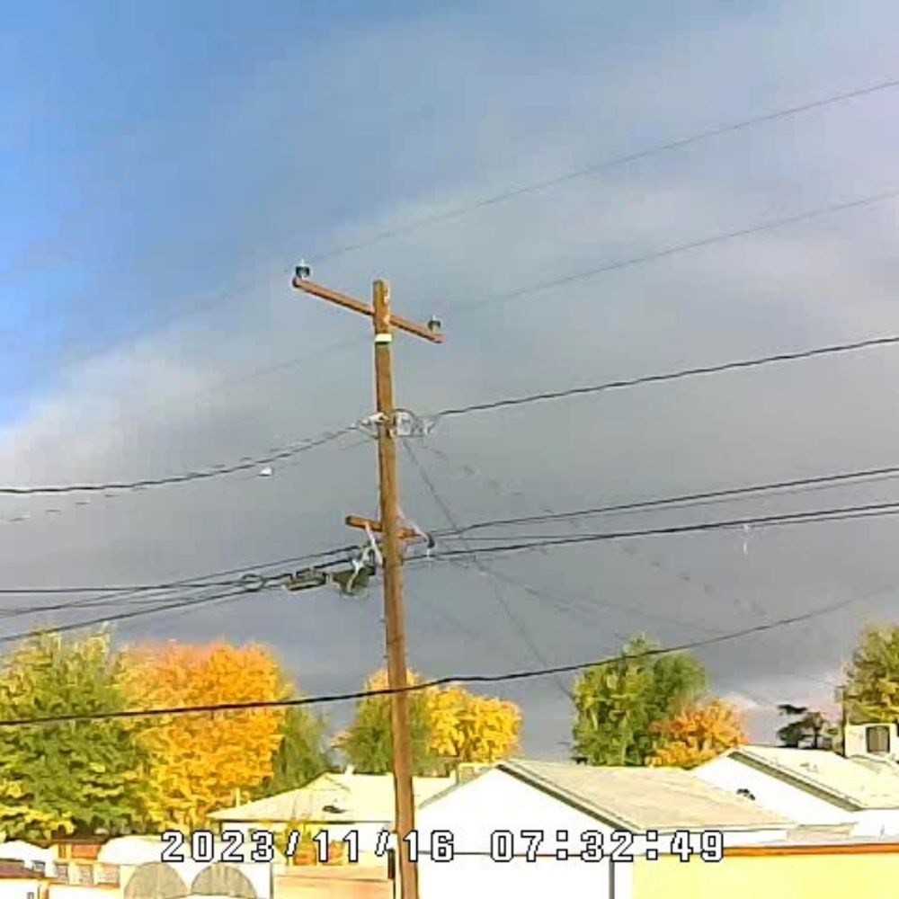
This should cheer you up 😅
#roadrunner
17.11.2025 19:31 — 👍 24 🔁 6 💬 2 📌 0


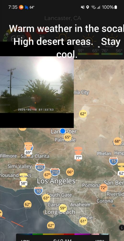
Rain for socal coming possible 1-3 inches in high desert areas higher in foothills.
12.11.2025 23:26 — 👍 0 🔁 0 💬 0 📌 0
Category 5 Major Hurricane #Melissa has made landfall near New Hope in southwestern #Jamaica with winds of 185 mph.
28.10.2025 17:14 — 👍 38 🔁 17 💬 1 📌 1

tropical weather outlook over the next 2 days greyscale satellite image of Eastern Pacific Ocean for
NWS National Hurricane Center Miami FL
500 AM PDT Wed Oct 8 2025
For the eastern and central North Pacific east of 180 longitude:
Active Systems:
The National Hurricane Center is issuing advisories on Tropical
Storm Octave, located well southwest of the southern tip of the Baja
California Peninsula, and on Hurricane Priscilla, located a couple
of hundred miles southwest of the southern tip of the Baja
California Peninsula.
1. South of Southern Mexico (EP90):
A large and persistent area of showers and thunderstorms remains
disorganized near and to the west of a broad area of low pressure
located in the Gulf of Tehuantepec. Environmental conditions
appear conducive for gradual development over the next few days,
and a tropical depression is likely to form late this week if the
system remains over water. The disturbance is forecast to move
west-northwestward at 10 to 15 mph, roughly parallel to the coast
of southern and southwestern Mexico, and interests there should
monitor its progress. Regardless of development, the disturbance
is expected to produce periods of heavy rainfall along portions of
the southern and southwestern coasts of Mexico through the end of
the week, which could lead to localized flooding.
* Formation chance through 48 hours...high...70 percent.
* Formation chance through 7 days...high...80 percent.
Forecaster Hagen

tropical weather outlook over the next 7 days color illustrated image of Eastern Pacific Ocean for
NWS National Hurricane Center Miami FL
500 AM PDT Wed Oct 8 2025
For the eastern and central North Pacific east of 180 longitude:
Active Systems:
The National Hurricane Center is issuing advisories on Tropical
Storm Octave, located well southwest of the southern tip of the Baja
California Peninsula, and on Hurricane Priscilla, located a couple
of hundred miles southwest of the southern tip of the Baja
California Peninsula.
1. South of Southern Mexico (EP90):
A large and persistent area of showers and thunderstorms remains
disorganized near and to the west of a broad area of low pressure
located in the Gulf of Tehuantepec. Environmental conditions
appear conducive for gradual development over the next few days,
and a tropical depression is likely to form late this week if the
system remains over water. The disturbance is forecast to move
west-northwestward at 10 to 15 mph, roughly parallel to the coast
of southern and southwestern Mexico, and interests there should
monitor its progress. Regardless of development, the disturbance
is expected to produce periods of heavy rainfall along portions of
the southern and southwestern coasts of Mexico through the end of
the week, which could lead to localized flooding.
* Formation chance through 48 hours...high...70 percent.
* Formation chance through 7 days...high...80 percent.
Forecaster Hagen
NWS National Hurricane Center Miami FL
500 AM PDT Wed Oct 8 2025
For the eastern and central North Pacific east of 180 longitude:
Active Systems:
The National Hurricane Center is issuing advisories on Tropical
Storm Octave, located well southwest of the southern tip of the Baja
California Penins
08.10.2025 12:15 — 👍 1 🔁 1 💬 0 📌 0

tropical weather outlook over the next 2 days greyscale satellite image of Eastern Pacific Ocean for
NWS National Hurricane Center Miami FL
500 PM PDT Tue Sep 16 2025
For the eastern and central North Pacific east of 180 longitude:
Active Systems:
The National Hurricane Center is issuing advisories on Tropical
Depression Mario, located several hundred miles west of the southern
tip of the Baja California Peninsula.
1. Off the Coast of Southwestern Mexico (EP96):
Disorganized showers and thunderstorms associated with a broad area
of low pressure located a few hundred miles off the coast of
southwestern Mexico have become more concentrated over the past
several hours. Environmental conditions appear conducive for
additional development of this system, and a tropical depression is
likely to form during the next couple of days as it moves
west-northwestward at 10 to 15 mph over the central east Pacific.
*Formation chance through 48 hours...high...70 percent.
*Formation chance through 7 days...high...90 percent.
Forecaster Hagen

tropical weather outlook over the next 7 days color illustrated image of Eastern Pacific Ocean for
NWS National Hurricane Center Miami FL
500 PM PDT Tue Sep 16 2025
For the eastern and central North Pacific east of 180 longitude:
Active Systems:
The National Hurricane Center is issuing advisories on Tropical
Depression Mario, located several hundred miles west of the southern
tip of the Baja California Peninsula.
1. Off the Coast of Southwestern Mexico (EP96):
Disorganized showers and thunderstorms associated with a broad area
of low pressure located a few hundred miles off the coast of
southwestern Mexico have become more concentrated over the past
several hours. Environmental conditions appear conducive for
additional development of this system, and a tropical depression is
likely to form during the next couple of days as it moves
west-northwestward at 10 to 15 mph over the central east Pacific.
*Formation chance through 48 hours...high...70 percent.
*Formation chance through 7 days...high...90 percent.
Forecaster Hagen
NWS National Hurricane Center Miami FL
500 PM PDT Tue Sep 16 2025
For the eastern and central North Pacific east of 180 longitude:
Active Systems:
The National Hurricane Center is issuing advisories on Tropical
Depression Mario, located several hundred miles west of the southern
tip of the Baja
17.09.2025 00:34 — 👍 1 🔁 1 💬 0 📌 0
NAM Satellite Depiction - Subtropical Moisture from the remnants of #Mario will be pulled Northward into #SoCal later this week. While rainfall amounts still need to be pinned down, it looks like all locations will see a chance for rain & Thunderstorms between Wednesday and Friday PM. #CAwx
15.09.2025 22:15 — 👍 1 🔁 1 💬 0 📌 1

tropical weather outlook over the next 2 days greyscale satellite image of Atlantic Ocean for
NWS National Hurricane Center Miami FL
200 AM EDT Sun Sep 14 2025
For the North Atlantic...Caribbean Sea and the Gulf of Mexico:
1. Eastern and Central Tropical Atlantic:
A tropical wave over the eastern tropical Atlantic is producing a
large area of disorganized showers and thunderstorms. Although dry
and stable air is expected to limit development during the next
couple of days, some gradual organization is possible thereafter,
and a tropical depression could form during the middle to latter
part of next week as the system moves west-northwestward to
northwestward at 10 to 15 mph over the central tropical Atlantic.
* Formation chance through 48 hours...low...near 0 percent.
* Formation chance through 7 days...medium...60 percent.
Forecaster Jelsema

tropical weather outlook over the next 7 days color illustrated image of Atlantic Ocean for
NWS National Hurricane Center Miami FL
200 AM EDT Sun Sep 14 2025
For the North Atlantic...Caribbean Sea and the Gulf of Mexico:
1. Eastern and Central Tropical Atlantic:
A tropical wave over the eastern tropical Atlantic is producing a
large area of disorganized showers and thunderstorms. Although dry
and stable air is expected to limit development during the next
couple of days, some gradual organization is possible thereafter,
and a tropical depression could form during the middle to latter
part of next week as the system moves west-northwestward to
northwestward at 10 to 15 mph over the central tropical Atlantic.
* Formation chance through 48 hours...low...near 0 percent.
* Formation chance through 7 days...medium...60 percent.
Forecaster Jelsema
NWS National Hurricane Center Miami FL
200 AM EDT Sun Sep 14 2025
For the North Atlantic...Caribbean Sea and the Gulf of Mexico:
14.09.2025 06:11 — 👍 0 🔁 2 💬 0 📌 0

tropical weather outlook over the next 2 days greyscale satellite image of Eastern Pacific Ocean for
NWS National Hurricane Center Miami FL
500 AM PDT Sun Sep 14 2025
For the eastern and central North Pacific east of 180 longitude:
1. South of Baja California Peninsula (Ex-Mario):
Shower and thunderstorm activity has become better organized with
the the remnants of Mario, located a few hundred miles south of the
Baja California Peninsula. Earlier satellite wind data also
indicated the circulation had become better defined. If the ongoing
deep convection persists, Mario is likely to become a tropical
cyclone again, and advisories may be re-initiated as soon as later
this morning as the system moves slowly westward at around 10 mph.
*Formation chance through 48 hours...high...70 percent.
*Formation chance through 7 days...high...70 percent.
2. Off the Coast of Southwestern Mexico:
An area of low pressure could develop well offshore of the coast of
southern or southwestern Mexico early this week. Environmental
conditions are expected to be conducive for gradual development as
the low tracks west-northwestward around 10 to 15 mph.
*Formation chance through 48 hours...low...near 0 percent.
*Formation chance through 7 days...low...30 percent.
3. South and Southeast of the Hawaiian Islands:
Showers and thunderstorms associated with a weak area of low
pressure well southeast of the Hawaiian Islands have decreased since
yesterday. Environmental conditions are forecast to become less
conducive for development during the next few days as the system
moves westward around 10 mph, and the potential for tropical cyclone
development appears to be decreasing.
*Formation chance through 48 hours...low...near 0 percent.
*Formation chance through 7 days...low...10 percent.
Forecaster Jelsema/Papin

tropical weather outlook over the next 7 days color illustrated image of Eastern Pacific Ocean for
NWS National Hurricane Center Miami FL
500 AM PDT Sun Sep 14 2025
For the eastern and central North Pacific east of 180 longitude:
1. South of Baja California Peninsula (Ex-Mario):
Shower and thunderstorm activity has become better organized with
the the remnants of Mario, located a few hundred miles south of the
Baja California Peninsula. Earlier satellite wind data also
indicated the circulation had become better defined. If the ongoing
deep convection persists, Mario is likely to become a tropical
cyclone again, and advisories may be re-initiated as soon as later
this morning as the system moves slowly westward at around 10 mph.
*Formation chance through 48 hours...high...70 percent.
*Formation chance through 7 days...high...70 percent.
2. Off the Coast of Southwestern Mexico:
An area of low pressure could develop well offshore of the coast of
southern or southwestern Mexico early this week. Environmental
conditions are expected to be conducive for gradual development as
the low tracks west-northwestward around 10 to 15 mph.
*Formation chance through 48 hours...low...near 0 percent.
*Formation chance through 7 days...low...30 percent.
3. South and Southeast of the Hawaiian Islands:
Showers and thunderstorms associated with a weak area of low
pressure well southeast of the Hawaiian Islands have decreased since
yesterday. Environmental conditions are forecast to become less
conducive for development during the next few days as the system
moves westward around 10 mph, and the potential for tropical cyclone
development appears to be decreasing.
*Formation chance through 48 hours...low...near 0 percent.
*Formation chance through 7 days...low...10 percent.
Forecaster Jelsema/Papin
NWS National Hurricane Center Miami FL
500 AM PDT Sun Sep 14 2025
For the eastern and central North Pacific east of 180 longitude:
14.09.2025 12:12 — 👍 1 🔁 1 💬 0 📌 0
Composite Radar as of 12:30pm 9/2/25 - Extensive showers and Thundershowers across Inland locations and local Deserts as a disturbance embedded in the Southerly flow aloft moves through. Showers could pop up anywhere across #SoCal Today, but will be more limited to the Mts/Deserts tomorrow. #CAwx
02.09.2025 19:43 — 👍 1 🔁 1 💬 0 📌 0
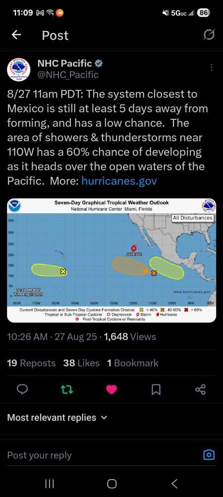
Lots of tropical activity in epac. Drawing up some moisture up into sw us.
27.08.2025 18:13 — 👍 0 🔁 0 💬 0 📌 0
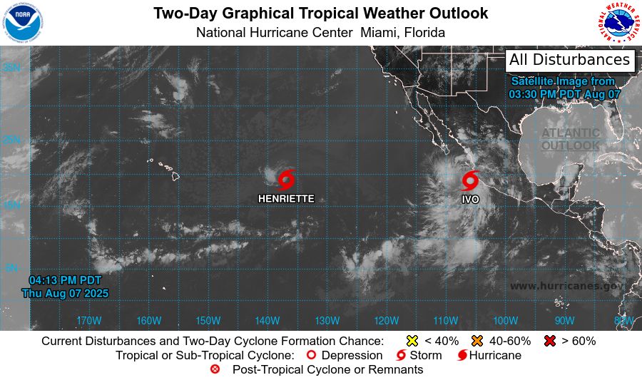
tropical weather outlook over the next 2 days greyscale satellite image of Eastern Pacific Ocean for
NWS National Hurricane Center Miami FL
500 PM PDT Thu Aug 7 2025
For the eastern and central North Pacific east of 180 longitude:
Active Systems:
The National Hurricane Center is issuing advisories on Tropical
Storm Henriette, located well east of the Hawaiian Islands.
Henriette is expected to move into the Central Pacific basin by
tonight. The National Hurricane Center is also issuing
advisories on Tropical Storm Ivo, located over the eastern
Pacific offshore of the coast of Southwestern Mexico.
Tropical cyclone formation is not expected over the next 7 days.
$$
Forecaster Jelsema
NNNN
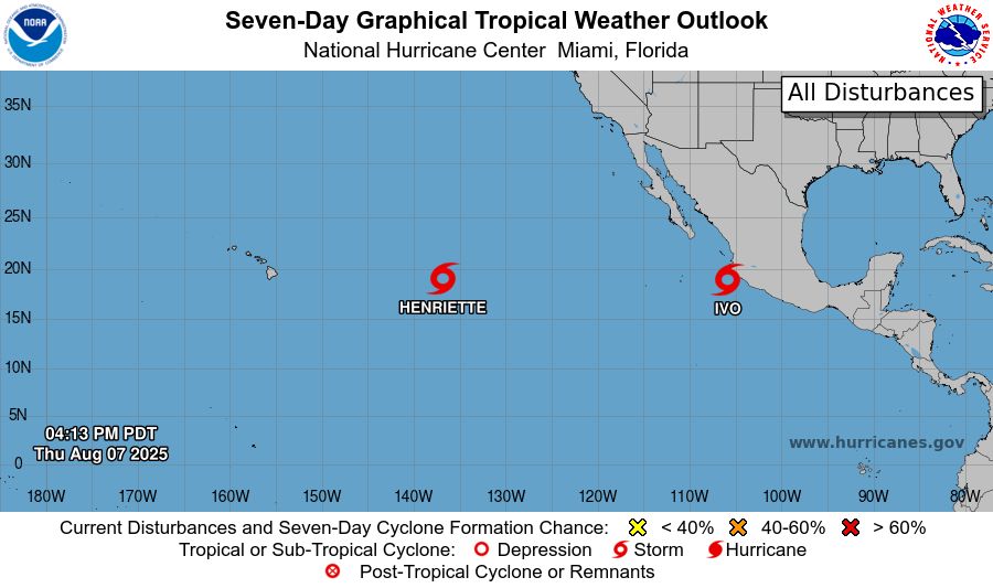
tropical weather outlook over the next 7 days color illustrated image of Eastern Pacific Ocean for
NWS National Hurricane Center Miami FL
500 PM PDT Thu Aug 7 2025
For the eastern and central North Pacific east of 180 longitude:
Active Systems:
The National Hurricane Center is issuing advisories on Tropical
Storm Henriette, located well east of the Hawaiian Islands.
Henriette is expected to move into the Central Pacific basin by
tonight. The National Hurricane Center is also issuing
advisories on Tropical Storm Ivo, located over the eastern
Pacific offshore of the coast of Southwestern Mexico.
Tropical cyclone formation is not expected over the next 7 days.
$$
Forecaster Jelsema
NNNN
NWS National Hurricane Center Miami FL
500 PM PDT Thu Aug 7 2025
For the eastern and central North Pacific east of 180 longitude:
Active Systems:
The National Hurricane Center is issuing advisories on Tropical
Storm Henriette, located well east of the Hawaiian Islands.
Henriette is expected to
08.08.2025 00:39 — 👍 2 🔁 1 💬 0 📌 0
For those in southeast California and southern Nevada:
Where is all the smoke coming from? The Gifford Fire north of Santa Barbara, California has burned nearly 50,000 acres & due to a persistent southwest flow.
This is a look of the fire as it continues to grow this evening.
04.08.2025 01:38 — 👍 5 🔁 2 💬 0 📌 0
A mesoscale convective vortex traveling across the Southwest US over the last two and a half days.
18.07.2025 19:46 — 👍 117 🔁 22 💬 2 📌 2
Composite Radar for #SoCal as of 11:40am 7/18/25 - There's some Storm development in the Mojave Desert along I-15 at the moment. High-res Models indicating Thunderstorm Development in the High Desert and local Mountains this afternoon with the chance for some showers drifting into Inland Valleys.
18.07.2025 18:49 — 👍 1 🔁 2 💬 0 📌 0

This incredible infrared image shows Monoceros R2, a star-forming region about 2,700 light-years.
It features young, massive stars lighting up reflection nebulae within a vast molecular cloud
(Credit: ESO/J. Emerson/VISTA. Acknowledgment: Cambridge Astronomical Survey Unit)
22.06.2025 22:21 — 👍 30 🔁 4 💬 0 📌 0

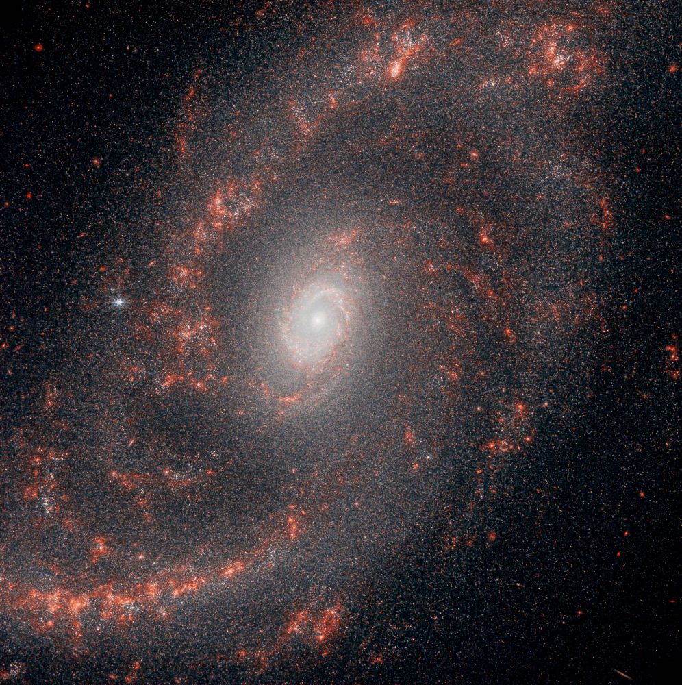
Remarkable: NGC 2775, a flocculent spiral galaxy 67 million light-years away, reveals delicate, feathery arms that point to a tranquil star formation history.
Credit: ESA/Hubble & NASA, J. Lee and the PHANGS-HST Team /Acknowledgement: Judy Schmidt (Geckzilla)
06.06.2025 22:33 — 👍 76 🔁 8 💬 0 📌 0
University are expensive. If the state fund them enough they wouldn't have issues
07.06.2025 00:41 — 👍 1 🔁 0 💬 0 📌 0
 31.05.2025 20:34 — 👍 0 🔁 0 💬 0 📌 0
Socal mini heatwave
10.05.2025 15:50 — 👍 0 🔁 0 💬 0 📌 0

Galaxies come in many shapes and sizes. One of the key galaxy types is the spiral galaxy.
NGC 2985 is a spectacular example, located over 70 million light-years from the solar system in the constellation of Ursa Major (the Great Bear).
(Credit: ESA/Hubble & NASA, L. Ho)
27.04.2025 15:50 — 👍 83 🔁 15 💬 1 📌 0

M81 and M82 galaxies

M51 Galaxy

The Owl Nebula, M97
We've had an amazing week of good weather so have been trying it the new equatorial mode for the Seestar S30 and S50. To these last night. Clear but fairly light polluted skies.
#astrophotography
17.04.2025 18:11 — 👍 14 🔁 2 💬 0 📌 0
A Stunning view!
Omega Centauri is a top pick for southern hemisphere stargazers. Even though it's 17,000 light-years distant, it appears nearly as large as the full Moon from a dark vantage point.
(Credit: NASA & ESA, N. Bartmann/ESA/Hubble)
13.04.2025 16:27 — 👍 45 🔁 10 💬 1 📌 0
The Leo Trio. It's no coincidence that these 3 galaxies are together in one frame. Focal length 1500mm. They are actually close together, so much so, their gravity is tugging on each other. Total of 40 hours of data from my backyard in BC, Canada.
#astrophotography #astronomy #space #galaxy
06.03.2025 16:33 — 👍 125 🔁 14 💬 4 📌 0

Hurtling through space at a staggering 7 million km/h, the barred spiral galaxy ESO 137-001 heads toward the centre of the Abell 3627 cluster, cutting through intergalactic gas heated to 100 million degrees Celsius, resulting in breathtaking visuals.
(Credit: NASA, ESA, CXC)
01.03.2025 23:05 — 👍 45 🔁 11 💬 1 📌 0

NGC 2841
https://www.astrobin.com/x0i75t/?utm_source=astrobin&utm_medium=email&utm_campaign=notification&from_user=96542
Here we have a flocculent spiral galaxy, a type of spiral galaxy whose arms are patchy and discontinuous-
NGC 2841 appearing in Ursa Major photographed over 2 evenings last week, with an 8" SCT at 2000mm f/10 with 5 minute exposures totaling over 14 hours.
#astrophotography #astronomy
26.02.2025 22:02 — 👍 121 🔁 17 💬 3 📌 1
his NIRCam image from the James Webb Space Telescope presents a stunning view of the spiral galaxy NGC 5248. The galaxy's prominent central bulge shines with a bright, almost uniform glow, indicative of a dense population of older stars. From this core, intricate spiral arms extend outwards, swirling in a grand design that dominates the frame. These arms are not uniform; they are punctuated by bright, clumpy regions of star formation, marked by a fiery orange glow, contrasting sharply with the darker areas of dust and gas. The overall image reveals the galaxy's majestic structure and the ongoing processes of star birth and evolution, captured in exquisite detail by Webb's powerful infrared vision.
NGC 5248 (NIRCam image).
Processed by @thocarp.bsky.social
www.flickr.com/photos/19746...
25.02.2025 20:24 — 👍 582 🔁 63 💬 5 📌 1

An awe-inspiring view of the Pillars of Creation, with radiant young stars cutting through the dark clouds of dust and gas, captured in infrared.
(Credit: NASA, ESA, and the Hubble Heritage Team - STScI/AURA)
24.02.2025 22:54 — 👍 43 🔁 13 💬 0 📌 0

The Flaming Star Nebula is a stunning emission and reflection nebula located in the constellation Auriga. Its vibrant red hues are due to the ionized hydrogen gas emitting light, while the blue areas result from light reflected by interstellar dust. It is associated with the star AE Aurigae, which energizes the surrounding gas and dust.
The Flaming Star Nebula's vibrant red hues are due to the ionized hydrogen gas emitting light, while the blue areas result from light reflected by interstellar dust.
Check out other observations from the Trottier Observatory: www.sfu.ca/science/comm... 🔭
26.02.2025 00:06 — 👍 892 🔁 119 💬 11 📌 3

look
26.02.2025 01:09 — 👍 1590 🔁 319 💬 39 📌 7
California Governor's Office of Emergency Services
Prepare · Respond · Recover
Public safety research program based at UC San Diego
Learn more: ALERTCalifornia.org
Live natural hazard monitoring cameras: cameras.ALERTCalifornia.org
The California Department of Forestry and Fire Protection. Serving and safeguarding the people and protecting the property and resources of California.
https://linktr.ee/calfire_official
A friendly robot that reports earthquakes in Los Angeles as they happen.
#micro magnitude 1 to 2.4
#minor 2.5 to 3.9
#light 4 to 4.9
#moderate 5 to 5.9
#strong 6 to 6.9
#major 7 to 7.9
#great 8+
Built by @alexanderbell.info
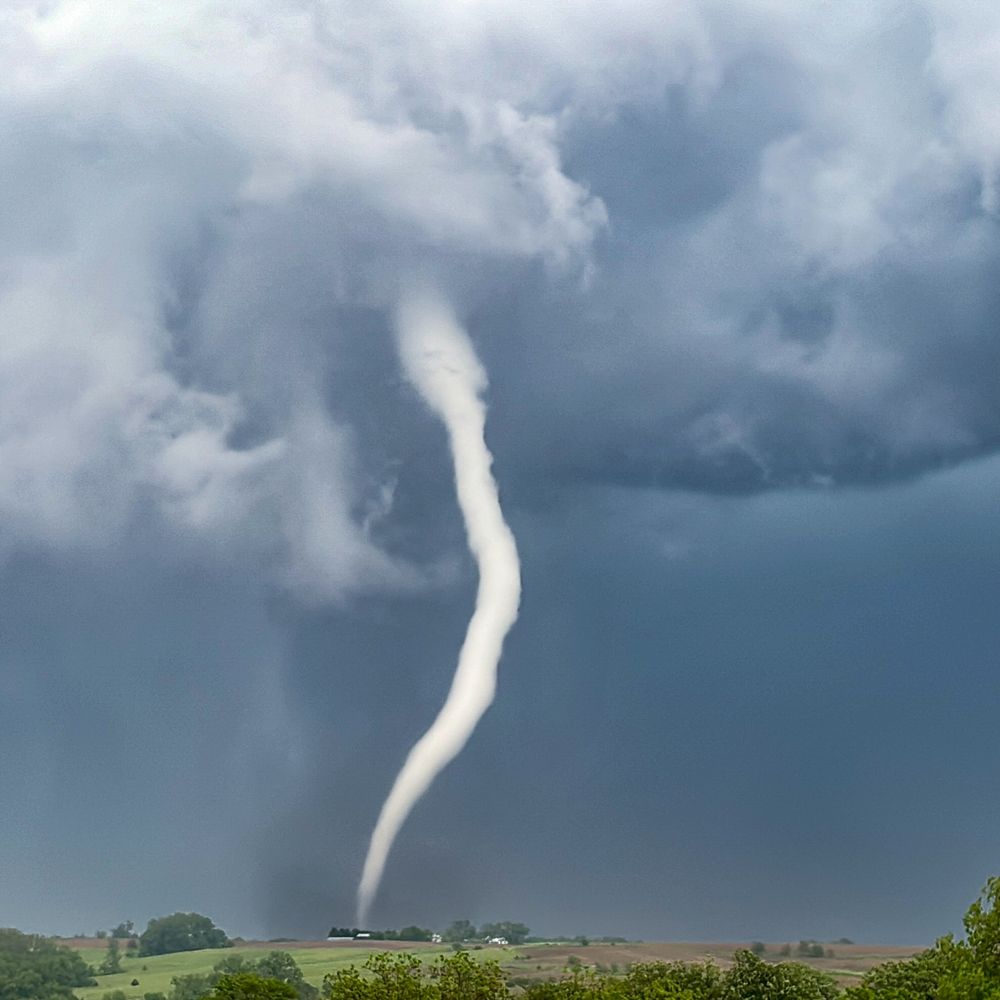
This account tracks severe weather and natural disasters in the U.S & Canada.
This includes tornadoes, hurricanes, earthquakes etc.
The Dr. Lucy Jones Center for Science & Society, founded by seismologist Dr. Lucy Jones, fosters the understanding & application of scientific information.
This bot pulls data from the USGS's real-time earthquake feed and posts a summary of any event in the lower 48 states having a preliminary magnitude 3.5+
made with 🫶🏼 by @DataDrivenMD.social
**NOT AFFILIATED WITH USGS**
All weather, all the time.
Weather. It's What We Do. #WeatherNation
For video/picture use, see our terms: http://weathernationtv.com/terms/
Palmdale, Lancaster, Quartz Hill, Gorman, Lake Los Angeles, Rosamond, Mojave, Sun Valley, Pearblossom, Llano, Neenach, Lake Hughes, Elizabeth Lake, Antelope Acres, Leona Valley, Littlerock, Edwards AFB
USA/Washington DC
by: Diana tc
@ditic.bsky.social
Keeping trees large and game down since 1876. National FORESTS 🌳 not parks
Mainly a parody account to make rangers laugh, but you see the state of the world
Documenting 🌪️🌩️weather, OU Meteorologists & and an MPA: severe weather education & resilience
https://www.atmosphericchaos.com
James Webb - Everything That's Hot 🔥
jwstfeed.com
It's weird being a parent. Here's a comic about it -except everyone is animals, because I hate drawing people.
https://lnk.bio/LitterboxComics
#CambioClimatico #Klimawandel #LeChangementClimatique
#ClimateChaos #HeatKills🔥
#EndFossilFuelAddiction #BigOilDidThis
#BlueCrew #PresidentJoeBiden 🌊 🌊 🌊
#XRefugee
Weather Station - uoıʇɐʇs ɹǝɥʇɐǝʍ ™
Ecowitt | WS69 | GW1100🔹Raspberry Pi🔹CumulusMX🔹Python🔹AT Protocol
Pokémon Content Daily
Turn on Post Notifications 📢
"We find the meaning of life in love, the value of existence in respect.”
The official Universal-Sci Bluesky account - Providing you with a selection of the most interesting science-related news and background stories - https://www.universal-sci.com/