YouTube video by Atmospheric Chaos Storm Chasing
March 9, 2017 - Crane, MO - Creepy Tornado Siren!
youtu.be/MMPUO54ugrc
31.10.2025 19:29 — 👍 1 🔁 0 💬 0 📌 0

In honor of Halloween, here is the creepiest tornado 🌪️ siren 🚨 sound EVER!! See below in the comments 👇
31.10.2025 19:28 — 👍 3 🔁 0 💬 1 📌 0

June 23, 2018 - Hollister, OK
LP supercell at sunset.
30.10.2025 21:49 — 👍 8 🔁 1 💬 0 📌 0

Dropsonde from the NE eyewall at 12:55z from hurricane hunter aircraft currently in the storm has 210 kt winds (241 mph) only maybe 100 meters or so off the surface. 925 mb was at 44m so 907 mb isn’t much higher. That’s just insane. #Melissa #hurricane
27.10.2025 14:41 — 👍 7 🔁 2 💬 0 📌 0

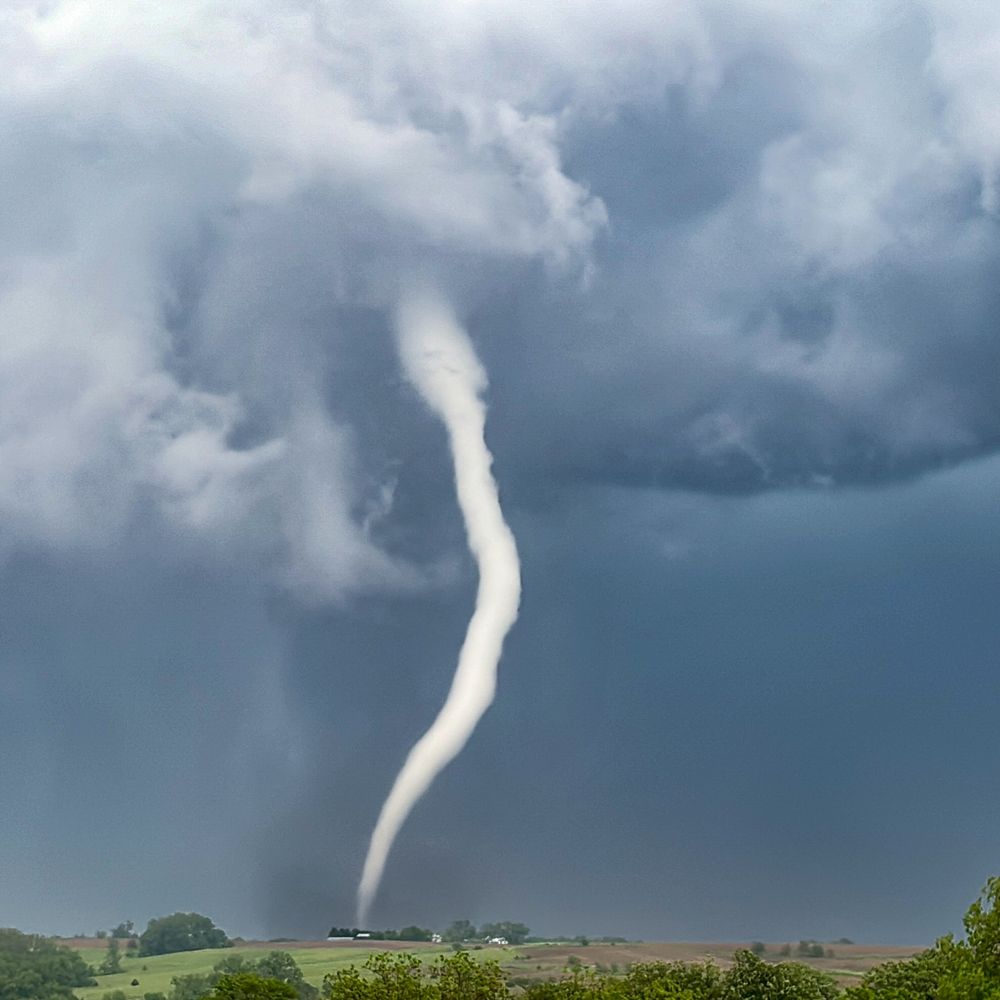
May 29, 2018 - Freedom, OK
HP beast along the KS/OK border. #okwx
26.10.2025 20:17 — 👍 4 🔁 0 💬 0 📌 0

Oct 5, 2018 - Ness City, KS
Sunset lighting up cumulonimbus along a cold front. #kswx
23.10.2025 20:59 — 👍 12 🔁 2 💬 0 📌 0

May 18, 2018 - Quinter, KS
A stationary supercell spins over town dumping lots of large hail up to baseball size. #kswx
20.10.2025 21:57 — 👍 13 🔁 1 💬 0 📌 0
YouTube video by Atmospheric Chaos Storm Chasing
Weathering The Storm
Launching our severe weather education series! Let us know what you’d be interested in learning more about! Thanks! www.youtube.com/watch?v=f1Dw...
18.10.2025 02:20 — 👍 4 🔁 0 💬 0 📌 0

Map showing that a level 2 out of 5 risk for severe storms is in place from northeast Texas to the Ohio River Valley on Saturday October 18, 2025. This includes cities like Shreveport, LA; Little Rock, Arkansas; Memphis, TN; Springfield, MO; and Paducah, KY. The severe storm hazards include damaging winds, a few tornadoes, and hail.

Storm Planning Timeline graphic giving tips on what people can do the day before severe storms strike like adjust plans, make sure your phone can receive Wireless Emergency Alerts, and ensure that your storm shelter is clean and accessible.
A severe storm threat is in place for more than 45 million people from northeast Texas to the Ohio River Valley on Saturday.
💨 Damaging winds
🌪️ A few tornadoes &
🧊 Hail are all possible
There is time today to make sure you are prepared. Visit weather.gov/safety for more.
17.10.2025 17:53 — 👍 90 🔁 35 💬 5 📌 8

A first-of-its-kind Integrated Warning Team forum in collaboration with digital meteorologists will take place the Sunday of #NWAS25 at 3 PM Central!
Watch a livestream of the forum on our YouTube channel: youtube.com/live/UNbXlL6...
Looking forward to this important discussion!
28.08.2025 01:23 — 👍 8 🔁 6 💬 0 📌 1

#sunset near Wells, Maine this evening! #summer
26.08.2025 01:47 — 👍 12 🔁 1 💬 0 📌 0
This supercell went on to produce the nighttime Bismarck, North Dakota #supercelk #sunset #photography
16.07.2025 20:43 — 👍 13 🔁 1 💬 0 📌 0

Anvil debris & a bit of mammatus at sunset this weekend! #sunset #photograghy
14.07.2025 22:10 — 👍 11 🔁 0 💬 0 📌 0

Just had an epic mammatus sunset north of Rapid City, SD! #sunset #photography
26.06.2025 03:28 — 👍 29 🔁 2 💬 0 📌 1

In Kearney, Nebraska a bit ago! #severethunderstorm #newx
25.06.2025 21:37 — 👍 9 🔁 1 💬 0 📌 0
I don’t think so
26.05.2025 05:14 — 👍 1 🔁 0 💬 0 📌 0
Thank you! The colors were fantastic
18.05.2025 15:49 — 👍 1 🔁 0 💬 0 📌 0

For many of us in the storm chasing community, May 3rd 1999 was a pivotal moment. (Much more so for the residents of Moore as the F5 tore through the community). Meteorologically this multi -dryline setup was unique and a fascinating case study. #tornadoes
04.05.2025 03:05 — 👍 9 🔁 1 💬 0 📌 0

April 15, 2017 - Protection, KS
Beautiful sunset LP supercell!
22.04.2025 00:16 — 👍 16 🔁 2 💬 0 📌 0

#hail in Coburg, IA a bit ago! #iawx
18.04.2025 03:00 — 👍 12 🔁 2 💬 0 📌 0

July 23, 2017 - Slaughterville, OK
Close CG with a summertime severe storm. This would produce an intense microburst a bit later, snapping off a half mile of power poles.
17.04.2025 03:36 — 👍 10 🔁 2 💬 0 📌 0

The next day after Mapleton-Pocahontas tornadofest, (April 10, 2011) we continued into Wisconsin and witnessed a couple tornadoes. This was the first by Friendship, WI. We then almost got hit by a tornado after dark in Neenah, WI. There was still snow in the ditches. #snow #tornadoes
11.04.2025 21:42 — 👍 6 🔁 0 💬 0 📌 0
Thanks!
10.04.2025 02:15 — 👍 2 🔁 0 💬 0 📌 0
Retired NWS-Oxnard meteorologist
I am Christian and believe right and wrong are decreed from the Bible. I am from Oklahoma City.
☀️ TV meteorologist
📍 Orlando, FL
🏡 Arlington, MA
Kiwi volcanologist working on Ngāuruhoe (Mt Doom) in NZ, the 2021 La Palma/Tajogaite eruption impacts, seafloor geologic hazards I 'On Shaky Ground' writer
#EarthCam encourages exploration, fosters discovery and connects people through innovative live camera technology. 🌎
Weather enthusiast/guesser
Aspiring broadcast meteorologist.
English/French/Romanian
Senior reporter @CBCNews covering Ontario politics on TV, radio & web. Dad, runner, XC skier, reader, cookie baker. #GoHabsGo Tips: DM or email mike.crawley@cbc.ca
BBC Senior Presenter (mostly Weather), communication trainer, runner, rower, cox and obsessive cat lady 🐈⬛
This is an automated bot which toots out National Weather Service CAP alerts for tornadoes. Experimental, and NOT OFFICIAL. DO NOT RELY ON FOR LIFE SAFETY! […]
[bridged from https://m.ai6yr.org/@nwstornado_bot on the fediverse by https://fed.brid.gy/ ]
proud dad & husband to NBCT. retired meteorologist, NOAA/NWS (30 years) and USFS (4 years). NM, mostly. FOSM and EMWPA volunteer. ⛈wx geek ❄️snow 🏔️mountains 🥾slow walks uphill 🎓OUSoM | UNMWater
Chief meteorologist at Global News. Weather, nature, biking, food, travel and dogs are my jam.
Morning Show Host | Content Creator | Producer🎥🌤️ @weathernetwork
Vancouver-based amateur photographer, with occasional comments on political issues.
Earth resilience, tipping behavior, nonlinear thinking, stability analysis, climate change, photosynthesis, soil respiration, tree mortality, Fulbright Scholar
President, Canadian Climate Institute/ président de l'Institut climatique du Canada
@climateinstitute.bsky.social
A coffee drinking cyclist who happens to be a meteorologist.
Media Relations Consultant @westernu.bsky.social
https://m.youtube.com/watch?v=CkR5NvwDhTE
📈 Climate Data Scientist
💼 at Deep Sky
🇨🇦 based in Toronto
👀 https://www.deepskyclimate.com/research
also Arsenal ⚽️ and hip hop 🎧