
Same here... eh boboy
01.04.2025 01:48 — 👍 12 🔁 0 💬 0 📌 0@trailgeek.bsky.social
Research scientist in Forest Ecology🌲| Working on climate change stuff and wildfires🔥| Like trail running and singing in my car

Same here... eh boboy
01.04.2025 01:48 — 👍 12 🔁 0 💬 0 📌 0
With less sea ice in this area over the last few years, many more baby seals are stranded on the shore:
(In French)
ici.radio-canada.ca/nouvelle/214...
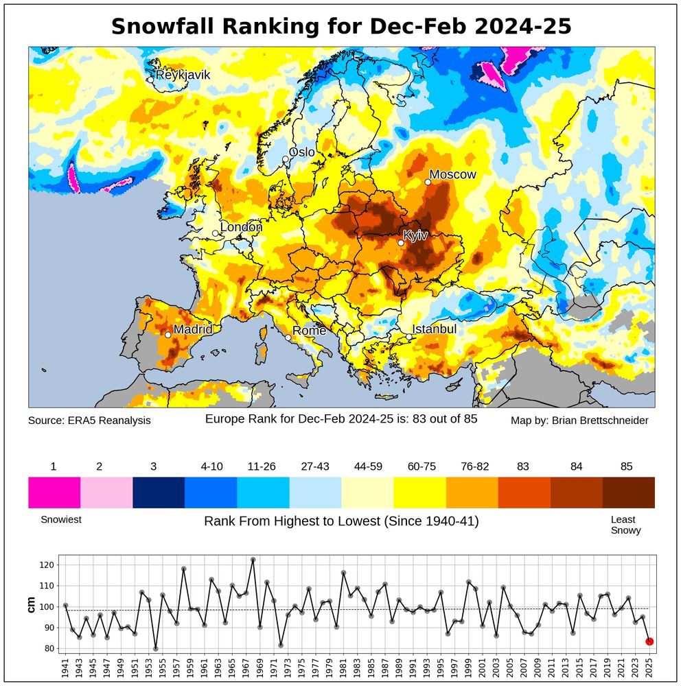
Europe had its least snowy winter (Dec-Feb) in over 50 years. #ThisIsFine
09.03.2025 14:52 — 👍 264 🔁 82 💬 7 📌 13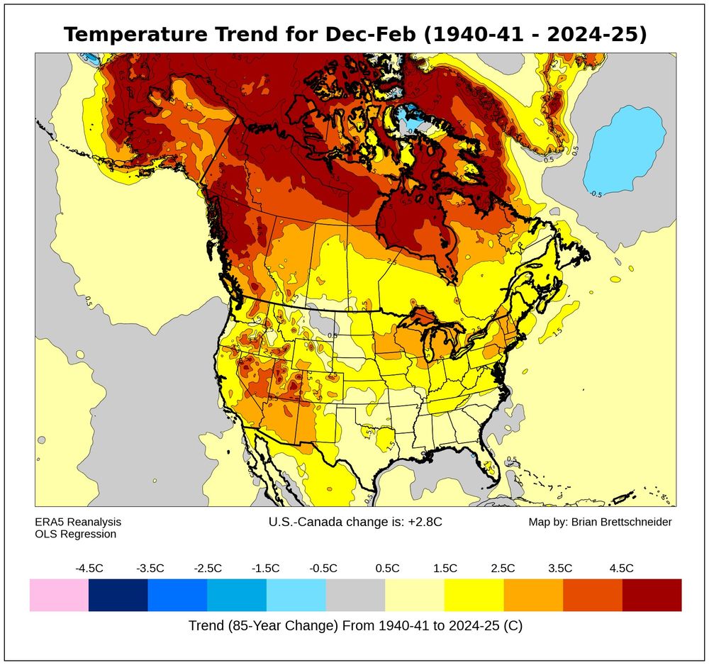
Q: Have winter (Dec-Feb) temperatures have changed (trend) over the last 85 years?
A: F*ck
Imagine if they also had to deal with the Phoenix pay system...
03.03.2025 17:12 — 👍 2 🔁 0 💬 0 📌 0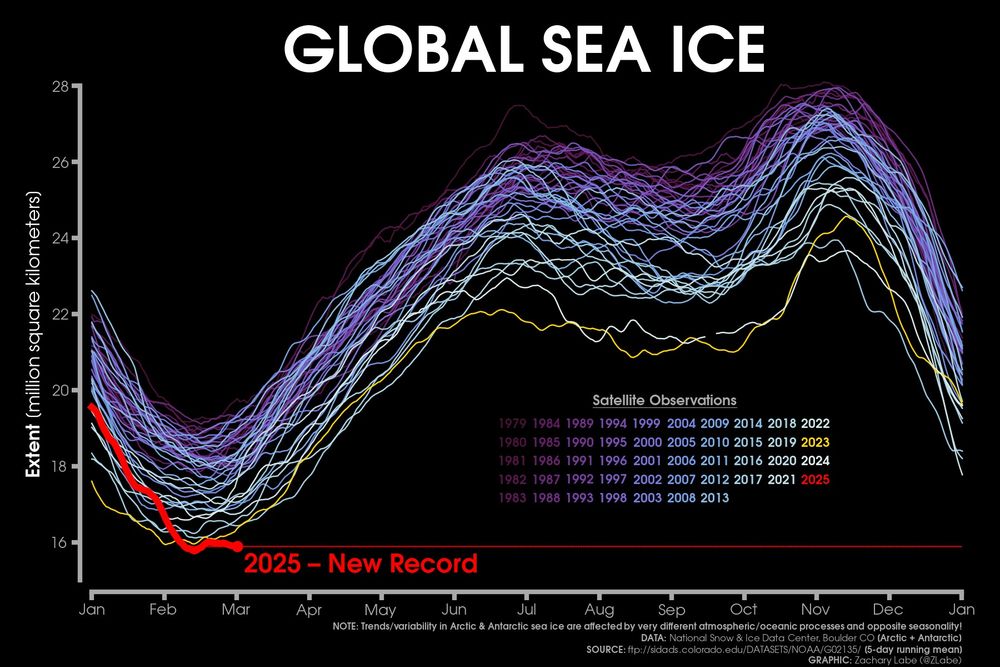
Line graph time series of 2025's daily global sea ice extent in red shading compared to each year from 1979 to 2024 using shades of purple to white for each line. There is substantial interannual and daily variability. Seasonal cycles are visible. Note: the poles are affected by very different Earth system processes/seasonality. I am using 5-day running mean data.
While all of this is happening to our scientific agencies, the current extent of sea ice globally remains at record low levels...
More visuals at zacklabe.com/global-sea-i...
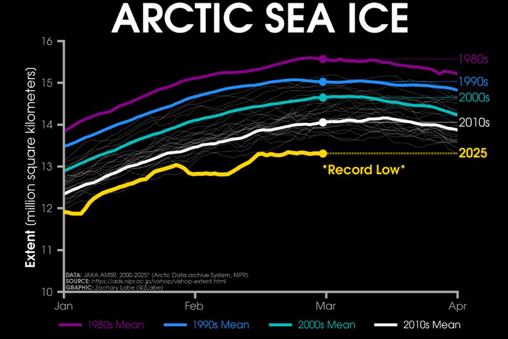
Line graph time series of 2025's daily Arctic sea ice extent compared to decadal averages from the 1980s to the 2010s. The decadal averages are shown with different colored lines with purple for the 1980s, blue for the 1990s, green for the 2000s, and white for the 2010s. Thin white lines are also shown for each year from 2000 to 2024. 2025 is shown with a thick gold line. There is a long-term decreasing trend in ice extent for every day of the year shown on this graph between January and April by looking at the decadal average line positions.
Sunday ice update - #Arctic sea ice extent is currently the lowest on record (JAXA data)
• about 740,000 km² below the 2010s mean
• about 1,340,000 km² below the 2000s mean
• about 1,720,000 km² below the 1990s mean
• about 2,260,000 km² below the 1980s mean
Plots: zacklabe.com/arctic-sea-i... 🌊
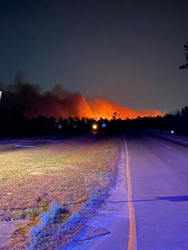
Just another typical late winter season in the Pyrocene -- "Wildfires rage across the Carolinas...More than 175 wildfires burning across SC and additional fires in NC... Much of eastern US seaboard under increased fire risk." www.yahoo.com/news/wildfir...
02.03.2025 18:36 — 👍 25 🔁 10 💬 4 📌 3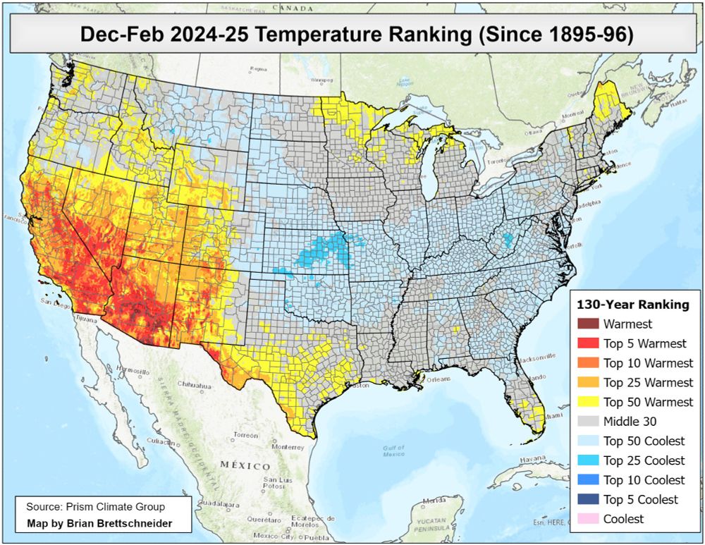
December-February 2024-25 temperature ranking since 1895-96 according to Prism climate data. Globally, this was the 2nd warmest Dec-Feb period, but the Contiguous U.S. was the outlier. Congrats!
01.03.2025 16:15 — 👍 52 🔁 13 💬 1 📌 1
Pass it on.
#StandWithUkraine
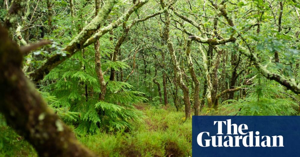
This is very concerning.
"Earth’s plants and soils reached peak carbon dioxide sequestration in 2008 but proportion absorbed has been declining since, study finds"
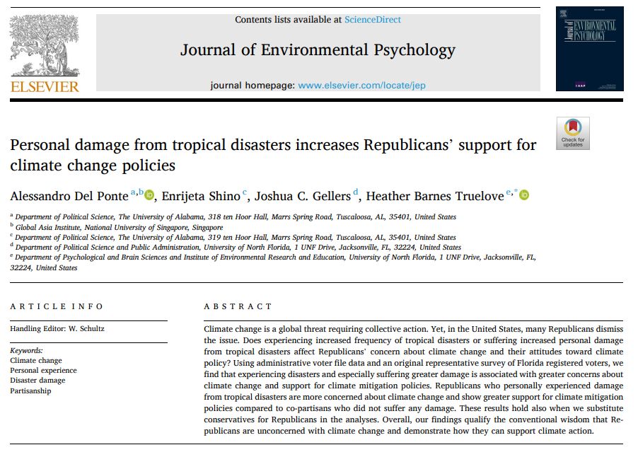
Another paper showing climate shocks lead to support for climate action among conservatives. Analyzing data collected in Florida, the paper finds Republican positions change after personally experiencing loss from climate-exacerbated extreme events.
www.sciencedirect.com/science/arti...
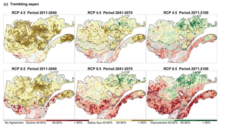
https://onlinelibrary.wiley.com/doi/10.1111/gcb.16014
Don't forget that this is considering a species distribution model (SDM) When using a multimodel approach, which includes both SDM and process-based models, iy appears that aspen might take advantage of increased climate-induced disturbances. Up to a certain point...
25.02.2025 01:50 — 👍 4 🔁 0 💬 0 📌 0Such conclusions also apply to #forest landscape #model projections over species distribution models
24.02.2025 13:35 — 👍 5 🔁 0 💬 0 📌 0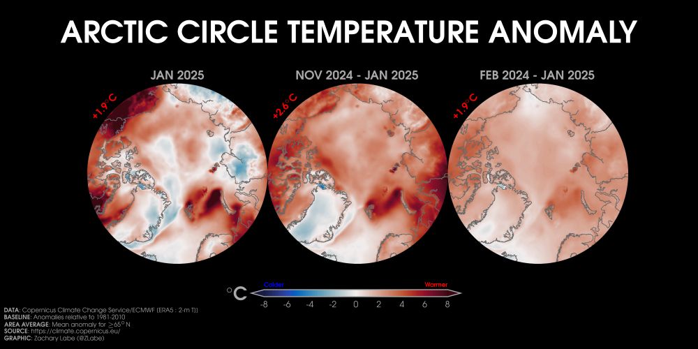
Three orthographic maps showing 2-m air temperature anomalies in January 2025, November 2024 to January 2025, and February 2024 to January 2025 in the Arctic region. Red shading is shown for warmer anomalies, and blue shading is shown for colder anomalies. Most areas are warmer than average. The mean temperature anomaly for each map is also displayed. Anomalies are calculated relative to a 1981-2010 baseline.
Looking at temperature anomalies over the last month (left), 3 months (center), and 12 months (right) across the #Arctic...
Data from doi.org/10.24381/cds... ⚒️
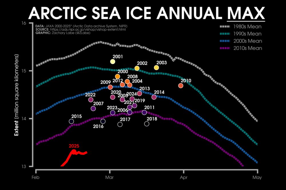
Line graph time series of 2025's daily Arctic sea ice extent compared to decadal averages from the 1980s to the 2010s. Additional scatter points show the maximum extents from 2000 to 2024. There is a long-term decreasing trend in ice extent for every day of the year.
Ice Watch - Time to start tracking the annual maximum #Arctic sea ice extent. A new record is definitely possible this winter. Stay tuned.
Follow the daily data at zacklabe.com/arctic-sea-i.... Data from JAXA. ⚒️🥼❄️
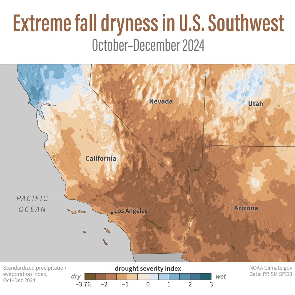
A trifecta of fire-friendly climate conditions fueled the January 2025 fires around Los Angeles: back-to-back wet winters that boosted vegetation, a record-dry fall, and extremely strong Santa Ana winds. See the map for how drought helped set the stage.
www.climate.gov/news-feature...

🔥🌲 Feux de forêt & climat : un sujet brûlant au Machin Club !
J’ai eu le plaisir de discuter de la saison record de 2023 et du rôle de la science pour mieux comprendre ces événements extrêmes. 🌍🔥
🎥 À voir ici 👉 www.youtube.com/watch?v=q_c0...
#FeuxDeForêt #Climat #ScienceEnAction #MachinClub
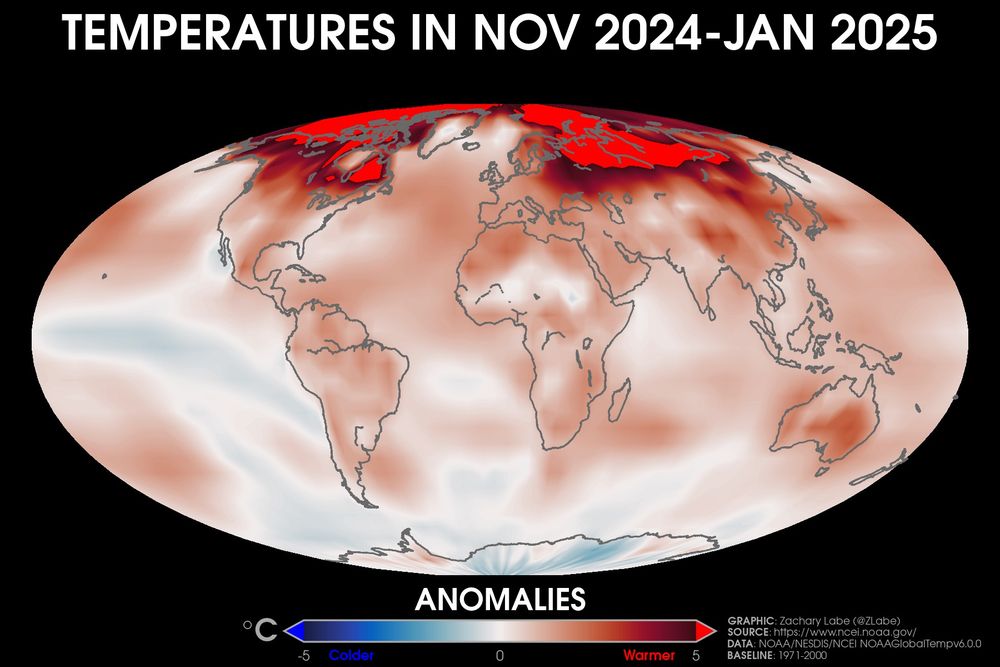
Global map showing surface air temperature anomalies for the November 2025 to January 2025 period across the entire planet. Most all areas were warmer than average, especially in the Arctic. This data set is from NOAA's NOAAGlobalTempv6.0.0 using anomalies with a 1971-2000 climate baseline. Red is shown for warmer than average temperatures, and blue is shown for colder than average temperatures.
Looking back at temperatures averaged over the last 3 months - find your location...
🟥 warmer than average
🟦 colder than average
Dataset (NOAAGlobalTempv6) described in doi.org/10.1175/BAMS...
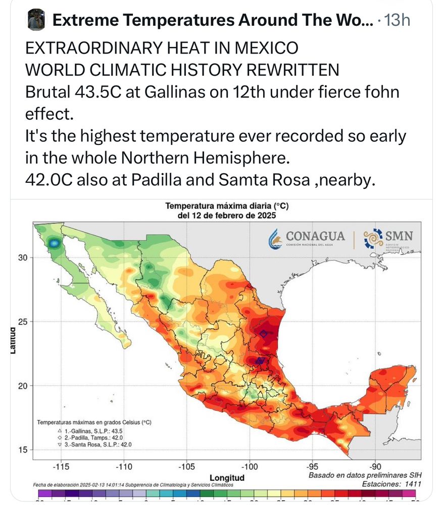
❗️Highest temperature ever recorded this early in the year across the Northern Hemisphere.
15.02.2025 14:42 — 👍 57 🔁 19 💬 2 📌 4
5/ 🔗 Want to dive deeper? Read our full study here:
📖 journals.plos.org/climate/arti...
4/ 🛠️ Why does this matter?
➡️ Changing pest distributions impact forest health & management
➡️ Increased defoliation risks in new areas
➡️ Need for proactive strategies to reduce vulnerability

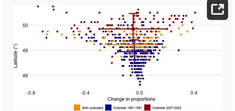
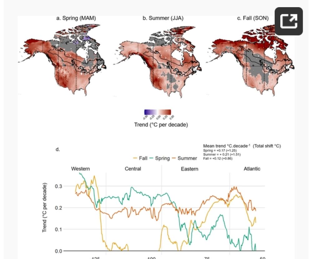
3/ 🌎 Most importantly, climate change is a bigger driver of SBW dynamics than landscape changes!
This means forest ecosystems are being reshaped faster than we expected, requiring adaptive management strategies.
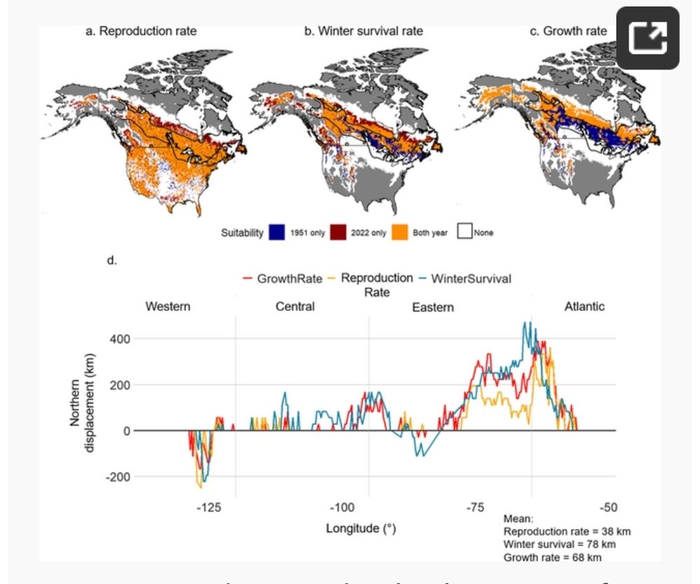
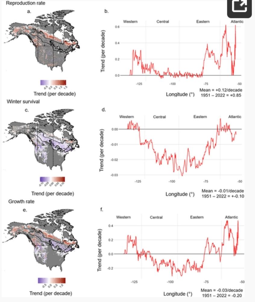
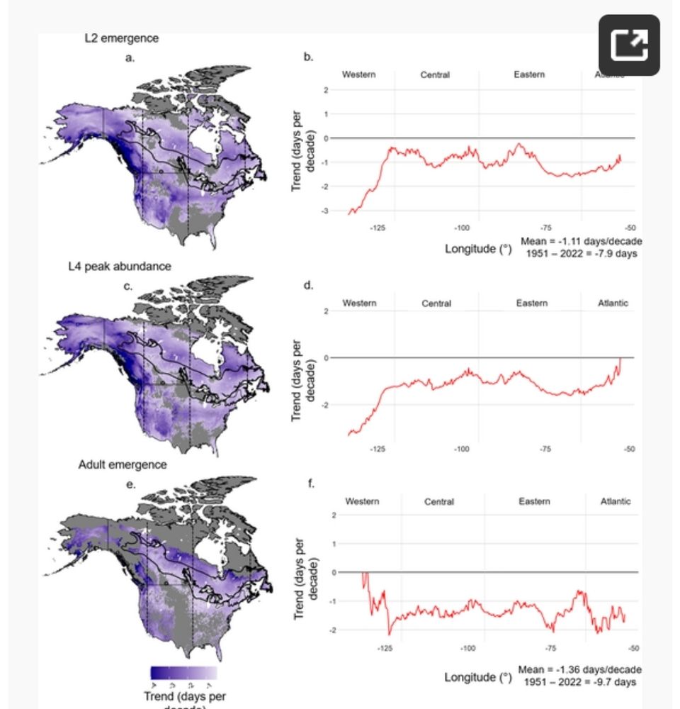
2/ 📈 Key findings (1950–2022):
📍 +68 km northward shift of suitable climate conditions (up to 200 km in some areas!)
⏳ Earlier phenological events & higher reproduction rates in the north
❄️ Increased winter mortality in the south due to warmer temperatures

1/ 🌲🔬 New Research Alert! 🌡️🦋
#ClimateChange is reshaping forest ecosystems, and the spruce budworm (Choristoneura fumiferana), a major boreal forest defoliator, is feeling the heat! 🔥
Our latest study in PLOS Climate reveals some striking trends. 🧵👇
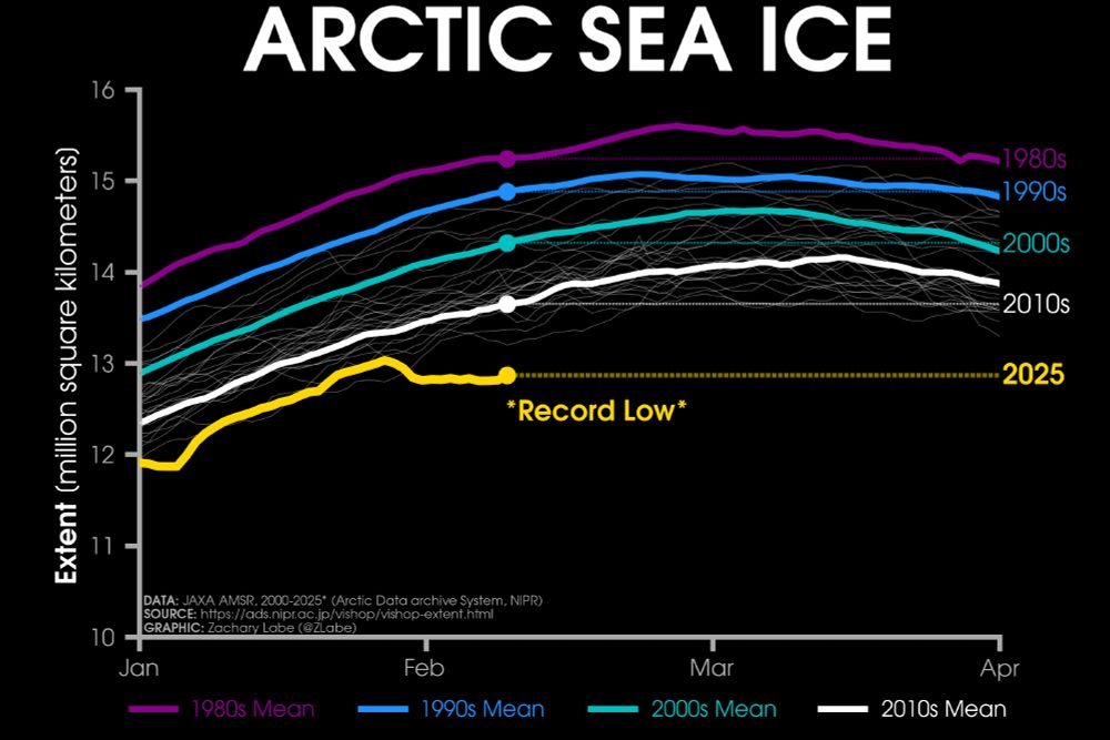
Line graph time series of 2025's daily Arctic sea ice extent compared to decadal averages from the 1980s to the 2010s. The decadal averages are shown with different colored lines with purple for the 1980s, blue for the 1990s, green for the 2000s, and white for the 2010s. Thin white lines are also shown for each year from 2000 to 2024. 2025 is shown with a thick gold line. There is a long-term decreasing trend in ice extent for every day of the year shown on this graph between January and April by looking at the decadal average line positions.
Monday ice update - #Arctic sea ice extent is currently the *lowest* on record (JAXA data)
• about 780,000 km² below the 2010s mean
• about 1,450,000 km² below the 2000s mean
• about 2,010,000 km² below the 1990s mean
• about 2,370,000 km² below the 1980s mean
Plots: zacklabe.com/arctic-sea-i... 🧪
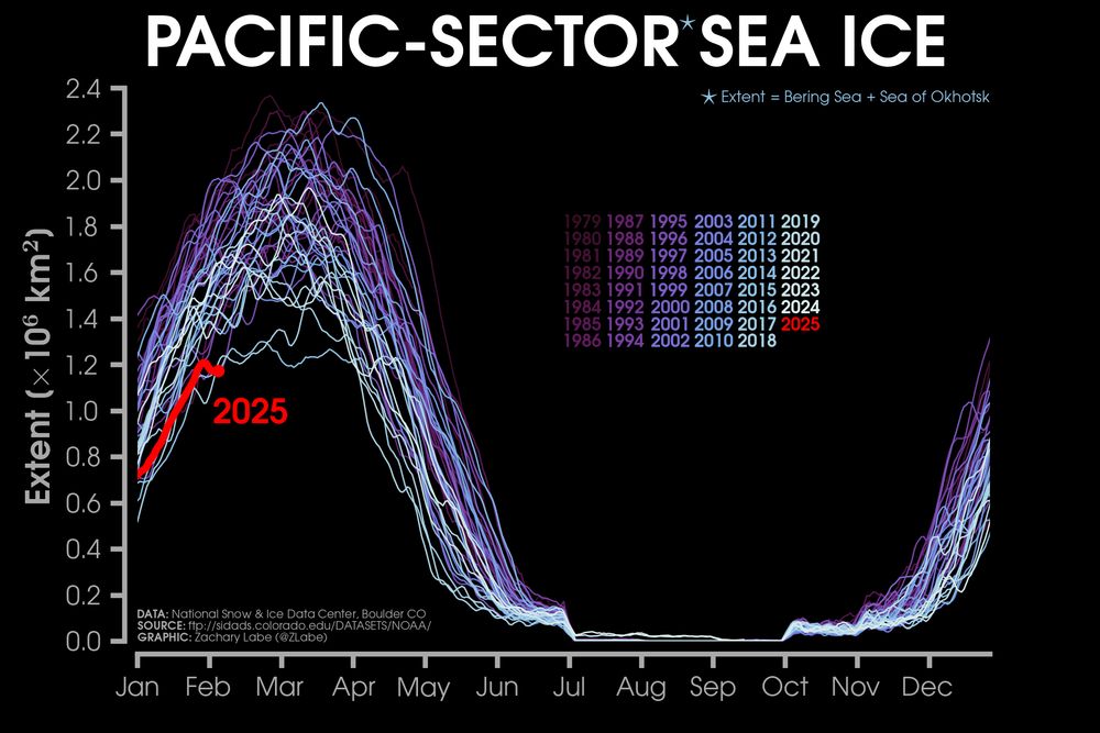
Graphic showing a line graph time series of daily Arctic sea ice extent in the Pacific sector of the Arctic (Bering Sea and Sea of Okhotsk) for each year from 1979 to 2024. This year is shown in red. Purple to white color shading is used for each other year's line. There is a long-term decreasing trend for every day of the year.
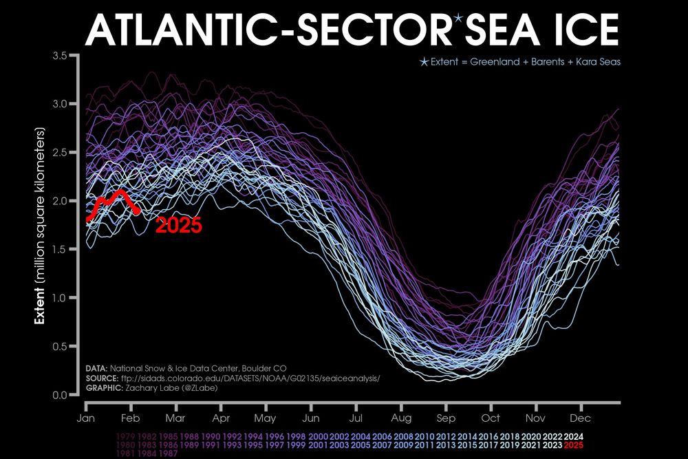
Graphic showing a line graph time series of daily Arctic sea ice extent in the Atlantic sector of the Arctic (Greenland + Barents + Kara Seas) for each year from 1979 to 2024. This year is shown in red. Purple to white color shading is used for each other year's line. There is a long-term decreasing trend for every day of the year.
Sometimes it is only one side of the #Arctic that experiences anomalously low conditions during winter, but this year we are seeing the sea ice edge on *both* the Atlantic & Pacific sectors at very low levels for this time of year. This is contributing to the historic record low for early February.
07.02.2025 01:12 — 👍 110 🔁 37 💬 3 📌 2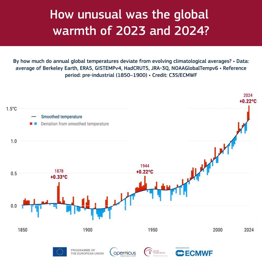
How unusual were 2023 and 2024 compared to the global warming trend, averaging an increase of around 0.2°C per decade?
Dive into the analysis of anthropogenic and natural factors 👉 bit.ly/40kQpcz
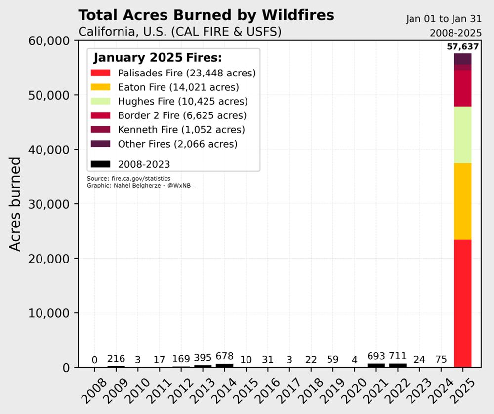
More acres have been burned by wildfires in January 2025 across California than in all the Januarys of the past 30+ years combined.
Unreal.