Saw it the other day and thought 'that's one for Marc'
16.02.2026 19:46 — 👍 1 🔁 0 💬 0 📌 0

Looking down the Incline Plane where the Shropshire Canal met the Wombridge Canal in Donnington Wood

Looking up towards the Cockshutt from where the Shropshire Canal once came

From Howard Williams's 'A Tour of the East Shropshire Canals' - 1962
Joining in with #gritsaltbinmonday & #mapsonmonday - sitting proud on the upper reaches of the Wrockwardine Wood Incline Plane of the (once) Shropshire (tub-boat) Canal
16.02.2026 19:11 — 👍 9 🔁 3 💬 1 📌 0

The Wrekin’s Danger Zones
When you stand at the Wrekin’s summit, the hill’s military connections & history aren’t obvious. Pedants may state that the summit’s Ordnance Survey’s Trig Pillar …
A new blog about the history of the Wrekin's Rifle Range from it's establishment because of the threat of French invasion in 1859; it's connection to the Olympic Games; the drive to close it from the 1970s; and fun & frivolities in the 2000s.
rowleyanth.wordpress.com/2026/01/31/t...
31.01.2026 07:42 — 👍 1 🔁 0 💬 0 📌 0
Morning Marc, thanks for the suggestion and it has been duly accepted. Submission to the IWM has been made.
16.01.2026 06:52 — 👍 1 🔁 0 💬 1 📌 0
No probs David - I've got a query open with them about digitising an item. MACE's advice is to leave it till after April when they have moved to a new site. They may be able to offer different £££s options after then.
12.01.2026 19:20 — 👍 1 🔁 0 💬 1 📌 0
Have a look at the Media Archive for Central England. Here's a sample of what is available featuring your dad > www.macearchive.org/films/atv-to...
I searched against Tony Butler
12.01.2026 18:50 — 👍 1 🔁 1 💬 1 📌 0
Another MACE video about Telford - this an ATV piece from 1979 on the (largely) positive work of TDC in Ironbridge to rejuvenate the town
It includes interviews with Eustace Rogers; the director of Blists Hill; and the late, great Billy Wright
www.macearchive.org/films/atv-to...
10.01.2026 19:45 — 👍 1 🔁 0 💬 0 📌 0
Hosted by the Media Archive for Central England: 'Dawley: The New Town Before Development'
Filmed in 1963, it is 22-mins of silent footage of the area around Dawley, Madeley & Ironbridge, towns that would subsequently form the southern extent of Telford New Town
www.macearchive.org/films/dawley...
08.01.2026 18:48 — 👍 2 🔁 0 💬 0 📌 0

Oakengates Fellowship FC
The photo below was published in the Telford Journal in May 1986 under the ‘Do You Remember When?’ regular feature. It shows two local football teams from 1936 – Wrockwardine Wood…
Oakengates Fellowship FC - an amateur football team that competed in the Wellington League before WWII
The linked blog contains a selection of the team's match reports from '37 & '38 when subs weren't allowed & goalies could be shunted over the goal-line
rowleyanth.wordpress.com/2025/12/29/o...
29.12.2025 13:36 — 👍 1 🔁 0 💬 0 📌 0

The 'LD' on the surface of the Boundary Stone probably stood for 'Leighton Estate' with 'WO' (on the hidden underside) standing for 'Wellington Orleton'.
Grid Reference: SJ 63649 08530
W3W ///gashes.pizzeria.meanings


An extract from the OS 25-Inch map 'Shropshire XLII.4' that was published in 1882. The location of the Boundary Stone is shown by the red circle in the bottom right-hand corner
On the lower slopes of the south side of the Wrekin (near to the Permissive Path) lies a toppled Boundary Stone that dates from at least the C19th
The BS marked the boundaries between the Duke of Cleveland's estate (now managed as the Raby Estate) to the west and the Orleton Estate to the east
19.12.2025 20:13 — 👍 6 🔁 1 💬 1 📌 0

The Bench Mark cut into the side of the toppled Boundary Stone. Grid Reference SJ 63290 08848 - W3W ///evenly.verb.wants.

The potential Pivot Mark in the Stone's top surface

The toppled & forgotten Boundary Stone. When toppled from its original position, rather than be carried down the hill, it was simply pushed down the Wrekin's north-face

An extract from the 25-Inch map 'Shropshire XLII.4' that was published in 1881. Circled, in it original position, is the Boundary Stone with Bench Mark
For #benchmarkmonday on the Wrekin's north-face, adjacent to the hill's Sentry Path is a Boundary Stone dating that dates from C19th that originally stood on the hill's lower ridgeline
Cut into the Boundary Stone is a Datum Line Bench Mark and (potential) Pivot mark
See Photo ALT for more details
10.11.2025 07:07 — 👍 5 🔁 0 💬 1 📌 0

25th October St Crispin's Day - along with his twin brother Crispinian - the Patron Saints of Shoemakers & Cobblers
Should probably be known as Saviours Day in Shrewsbury
25.10.2025 08:43 — 👍 3 🔁 1 💬 0 📌 0

The South Prospect of Bridgnorth, in the County of Salop by Samuel and Nathaniel Buck - 1732

The numbers of the eleven features detailed in the Index are circled

The Index
Best viewed in Landscape
From 1732 the South Prospect of Bridgnorth by Samuel and Nathanial Buck
Eleven features are picked out & numbered - the Index is in the bottom right-hand side of the picture's text
Panpudding Hill is on the left-hand centre side of the picture
23.10.2025 17:13 — 👍 2 🔁 1 💬 0 📌 0


The gate-post of the Enginuity car-park into which the cast-iron plaque is set
For #benchmarkmonday the cast-iron 'Cut Mark' at the Museum of Iron in Coalbrookdale - soon to be run by the National Trust. No evidence that its an official OS Bench Mark but I'd happily buy one if they were on sale at the Ironbridge Gorge Museums - Grid Reference SJ 66760 04705
20.10.2025 05:41 — 👍 3 🔁 2 💬 1 📌 0

A mosaic of the Wrekin, created by The Arts Society Wrekin in 2018 to mark the Gold Anniversary of The Arts Society that was established in 1968 by Patricia Fay as the National Association of Decorative and Fine Arts Societies (NADFAS) The mosiac is mounted in Weston Park, Staffs
02.10.2025 07:29 — 👍 6 🔁 3 💬 0 📌 0

Wellington (Shropshire) – An OS Benchmark Walk
The Arrow & Line cut into the wall on the side of a building – you may have seen one or more of them, wondering what it or they are. Some of us wander to find them. The Wellington (Shrops…
A new Telford based OS Benchmarks walk, this one based through & around Wellington.
Many thanks to the Wellington Walkers are Welcome group who gave me the opportunity to lead people around the route on Monday as part of the September Walking Festival
rowleyanth.wordpress.com/2025/09/12/w...
12.09.2025 14:29 — 👍 2 🔁 0 💬 0 📌 0
The story behind the benchmarks hiding in plain sight in Ireland
An interesting article on OS Benchmarks in Ireland and their link to ownership, authority and, from that, folklore. "benchmarks and particularly the broad arrow, can be seen not only as tools of measurement... but also authority and ownership"
Link > amp.rte.ie/amp/1525673/
05.08.2025 15:23 — 👍 0 🔁 0 💬 0 📌 0

1. The Shrewsbury Canal that ran from Ditherington to Trench Lock
2. The Ketley Canal
3. The Wombridge Canal
4. The Marquis of Stafford's Canal - aka the Lilleshall Canal
5. The Shropshire Canal (not to be confused with the Shropshire Union Canal)
6. The Dawley Canal
The Incline Planes of the system are shown in red and the three Tunnels of the Shropshire Canal in yellow.

For #mondaymaps an extract from Plate-V of Robert Baugh's 1808 map of Shropshire showing the various Tub Boat Canals and the Incline Planes & Tunnels of what is now Telford.
Not showing is the Newport Canal - this wasn't constructed until 1835.
More details of the Canals are provided in ALT
04.08.2025 06:55 — 👍 2 🔁 0 💬 0 📌 0
Just finished reading the excellent 'Church Going - a Stonemason's Guide to the Churches of the British Isles' by @old-church-going.bsky.social I found this an absorbing read describing the features & their history that you may find on the outside or inside of a medieval church - recommended!
31.07.2025 19:42 — 👍 0 🔁 0 💬 0 📌 0

I was on the Wrekin this morning for the Solstice Sunrise - here the rising sun is seen looking over the summit's Trig Pillar's Spider
21.06.2025 06:06 — 👍 8 🔁 1 💬 0 📌 0
The Digital Repository of Ireland (DRI) is a CoreTrustSeal-certified digital repository, or online archive, for the long-term preservation of Ireland's social and cultural digital legacy. Explore the Repository: https://repository.dri.ie/
Free, detailed walking routes in UK, especially Yorkshire. GPX downloads and precise starting points with parking info. Walking time calculator. Walking advice. Follow to be informed of new walks and miscellaneous stuff. Website happyhiker.co.uk
Native Maps SDKs Dev at Esri 👩🏻💻 | Flutter | Former Survey Geologist 🗺️ | GIS 🌍 | Software Development | Atlantic Rainforests 🌳 | Gaelic Placenames | Scottish Folklore 🧙♀️ | Old Maps
Hello, I’m a specialist Church Stonemason in Somerset- UK.
FSA & SPAB Fellow.
I’ve also recently taken to writing & have 2 books under my belt.👇
www.church-going.co.uk
www.the-stonemason.co.uk
www.one-place-studies.org – For excellence and enjoyable engagement in #OnePlaceStudies, where #FamilyHistory and #LocalHistory unite. Studying and celebrating places, their people, and their shared histories. Post about your OPS on #OnePlaceWednesday!
Medieval Churches, paintings, carvings, stained glass, gravestones,
Cathedral, Priory, Abbey,
Church traveller/crawler whenever possible -
Blog: https://church-travellers.eu/
Outdoor blogger & charity fundraiser #Walk2025Miles supporting The Trussell Trust #TrussellTrustAmbassador #TrigBagger twodogsandanawning.co.uk
Retired design engineer that worked in automotive and aerospace fields.
Specialised in the design of military vehicles.
BSc with honours. OU
Guitar and ukulele player (not at the same time)
Into all sorts of music.
Just joined a male voice choir.
No DM’s.
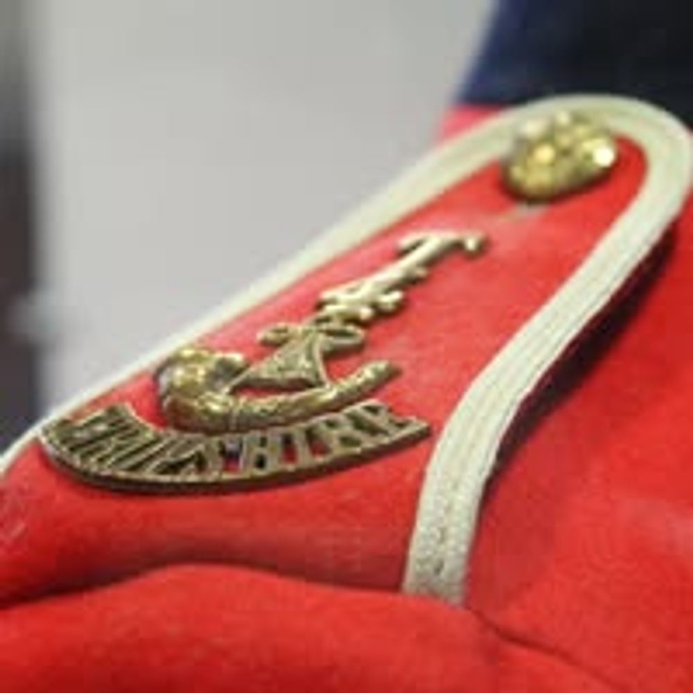
Welcome to Soldiers of Shropshire Museum at Bluesky! Visit us at Shrewsbury Castle to discover the stories of Shropshire soldiers and their families in war and peace, at home and abroad, from 1755 to the present day.
This account is managed by Nancy Mein!
Commuting between West London and Shropshire. Refugee from X. Wolves FC. European. Wondering where the middle ground has gone.
Looks after old places and their visitors. I like telling stories. Interested in 17th century, Covenanter and Jacobite history amongst other things. Green Party and PCS Union member. Living a plant-based life.
Retired from Sch. of GeoSciences, Uni. of Edinburgh, UK. Still works a bit on https://mls.jpl.nasa.gov/ . Walking, singing, Linux, bellringing, astronomy, geology, geophysics and meteorology. Dislikes extreme right or leftwing politics and nationalism.
The perfect place to begin your exploration, or rediscovery, of the Shropshire Hills. We'll give you ideas for places and things to do and see.
Craven Arms, Shropshire, UK
shropshirehillsdiscoverycentre.co.uk
Bestselling Author | Writer | Photographer
Business of Writing and Ask The Agent columnist at Writing Magazine.
Mortiforde Mysteries cosy crime series author
BBC WeatherWatcher
www.simonwhaley.co.uk
I live in #Telford, work in #adultsocialcare, interested in community development and currently being treated for #tonguecancer. Also follow football matters
telfordlive@gmail.com
https://www.telford-live.com/
Journalist, Editor & Foreign Correspondent | Lives in Normandy | Vernacular, church and hall-house architecture | Volunteer archaeologist | Timber & clay hall builder | Historian of C19th Chiot & Phanariot diaspora | Farmer. <ChristopherLong.co.uk> 🦋2023
Chief Officer @ Working Together Ludlow - charity supporting people with learning difficulties & disabilities. Views my own.
www.droversloft.co.uk
Profile by @drawnalism.bsky.social
Record and share your places!
We collect geographically interesting photos of UK and Ireland.
Aiming for at least one per 1km OS grid square
Moderated, classroom-ready, reusable, geo-located
8 million photos so far
http://www.geograph.org.uk/