Loch Dubh Cnoc na File, North Uist
According to the OS Name Book of 1876-1878, Loch Dubh Cnoc na File means Black Loch of the Fiddle Knoll, although the word "file" is translated as poet or bard, rather than fiddle, in various Gaelic dictionaries.
https://www.geograph.org.uk/photo/8087307

Sheep dip and pens by Loch Bì, South Uist
The OS six-inch 1st edition map, surveyed in 1878, shows a roofed building here.
https://www.geograph.org.uk/photo/8085125
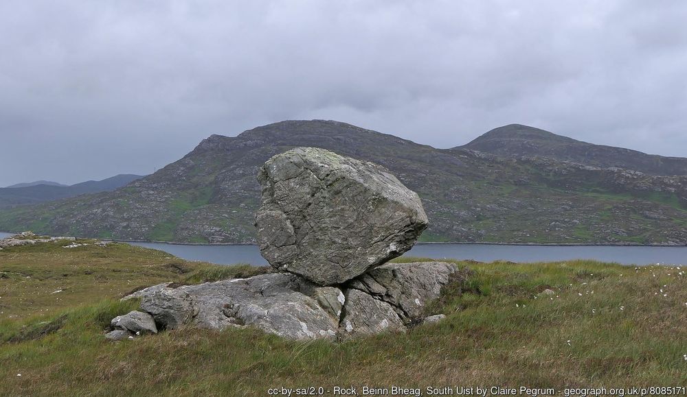
Rock, Beinn Bheag, South Uist
Looking towards Loch Baghasdail and the hills Beinn Ruigh Choinnich and Triuirebheinn.
https://www.geograph.org.uk/photo/8085171
Three of twenty new squares added this week in the Outer Hebrides. Great to see more wild areas getting recorded
www.geograph.org.uk/search.php?i...
www.geograph.org.uk/profile/3729
05.07.2025 14:10 — 👍 5 🔁 1 💬 0 📌 0

NG91 photo mosaic, one photo per 1km OS square (more are very welcome) https://www.geograph.org.uk/maplarge.php?t=tolJ5ojXXJ0ojXJFojXXJfoVubJqojNXJL5405o8jMuVaXajM4lVa8a
Another 10km square completed, NG91 in northwest Scotland. Still other gaps to fill by those who get into the wilds www.geograph.org.uk/search.php?i...
18.06.2025 11:40 — 👍 6 🔁 1 💬 0 📌 1

The Red Lion on Gloucester Street, Oxford. https://www.geograph.org.uk/photo/8034936 This may be the milestone image, if not it's close to it

Stats page, https://www.geograph.org.uk/numbers.php showing the image counter past eight million
The number of squares photographed in the last 5 years is currently rising rapidly, as 5 years ago was lockdown. All additional photos welcome!
Another milestone* reached, with 8 million photos now available on the site, all geolocated and CC-licensed from Great Britain and Ireland. A great record of our diverse islands. More photos always welcome!
*statistical milestone, we have tens of thousands of photos of actual milestones
02.05.2025 14:55 — 👍 3 🔁 2 💬 0 📌 0

Allt Coire a' Mhail, https://www.geograph.org.uk/photo/8023815

Hanging valley above Steall, https://www.geograph.org.uk/photo/8023811

NN16 map, with at least one photo per 1km square, taken from within the square (more photos always welcome!)

NN16 photo mosaic
Another 10km square completed, NN16, south of Fort William
www.geograph.org.uk/mapper/?lat=...
20.04.2025 22:49 — 👍 3 🔁 0 💬 0 📌 0

Corrie lochan below Sàbhal Beag https://www.geograph.org.uk/photo/8014841

Un-named tributary of Allt Beith a' Mheadhoin https://www.geograph.org.uk/photo/8014830

NC34 photo mosaic
NC34 OS map, with at least one photo per 1km square. More photos always welcome
Another 10km square completed, NC34 in northwest Scotland. Great to see remote areas getting more coverage. www.geograph.org.uk/mapper/?lat=...
15.04.2025 13:15 — 👍 6 🔁 0 💬 0 📌 0

Recent cliff fall, Sewerby Cliffs
Eroding cliffs at Sewerby. Image number 8,000,000 for the site and an excellent record of change, and geography in action
www.geograph.org.uk/photo/8000000
20.03.2025 08:15 — 👍 4 🔁 0 💬 0 📌 0

Woodchester Mansion, the first photo uploaded to the site (barring three test images)
Our first photo, submitted 20 years ago today. Now over 7,950,000 photos of Britain and Ireland on the site - where will our eight millionth be?
www.geograph.org.uk/photo/4
06.03.2025 10:57 — 👍 5 🔁 2 💬 0 📌 1

Photo showing farm fields, with a hill rolling down in front of us and trees lining the distant horizon. The time is early spring, so the trees are still without leaves, and the fields are without crops, having only short grass interspersed with dirt. Birds are either landing or taking off from the field to our left. It’s a cloudy day but fairly bright.
Farthing Street, Downe, Bromley, #London 📷
#LoveLondonWalkLondon
#LondonLoop
02.03.2025 08:39 — 👍 34 🔁 4 💬 1 📌 0
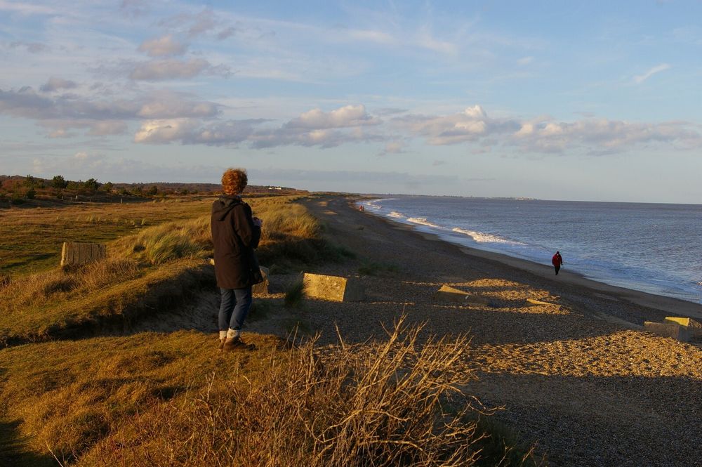
A view north along a curving coastline, in a slanting winter afternoon light. On the left are low dunes, on which the photographer is standing; occasional World War II anti-tank defences, in the form of concrete cubes, jut out at angles. On the right of the picture the shadows of the dunes cover the beach, then beyond that the sea, coloured slightly purple by the setting sun. A young man with red curly hair, wearing a duffle coat, is standing not far from the photographer, looking away up the coast; other figures are dotted along the beach at various intervals.
For the new month, here's a March image from one of my @geograph-gbi.bsky.social calendars, taken on this day five years ago: Looking North at Minsmere Haven.
www.geograph.org.uk/photo/7294441
01.03.2025 09:26 — 👍 2 🔁 1 💬 1 📌 0

Aysgarth Upper Falls in the snow, SE0088

Flooded field near Shinfield, SU7367

Clopton Bridge, SP2054
Three recently submitted photos, typical of the winter so far. Over 10,000 photos submitted already this year, as we rapidly approach our 8 millionth photo in the archive
19.01.2025 23:48 — 👍 7 🔁 1 💬 0 📌 1

A wind turbine blade moving through Hawick, https://www.geograph.org.uk/photo/7716666

The new Barmouth Bridge over the Afon Mawddach, https://www.geograph.org.uk/photo/7873266

Table Hill and North Hill, https://www.geograph.org.uk/photo/7946022

West Portal of Chalamain Gap, https://www.geograph.org.uk/photo/7884423
2024 in numbers:
268,748 photos submitted (bringing total to 7,915,829) by 622 contributors, covering 84,497 grid squares. Still more areas without photos in Ireland and the wilds of Scotland, and many more details and changes to record where we do have photos.
2025 will bring our 20th birthday!
01.01.2025 16:57 — 👍 6 🔁 1 💬 0 📌 0

Walking round the local vineyards. This one was first planted in 2017. It still seems odd to see them in the English landscape.
27.12.2024 13:51 — 👍 10 🔁 1 💬 0 📌 0
Photos quickly go from relatively mundane to important records of times past. We try to collect such photos and tell the story of our amazingly diverse islands, from pubs to seafronts to mountaintops and everything in between. All contributions welcome
22.12.2024 21:40 — 👍 4 🔁 2 💬 0 📌 0

Shieling at Airighean Tota Maol Moirag

NB03 photo mosaic, Isle of Lewis. We now have at least one photo of every 1km grid square with land, taken from within the grid square
Another 10km square completed, NB03 on Lewis with a photo of a ruined shieling www.geograph.org.uk/photo/7933626
09.12.2024 14:51 — 👍 5 🔁 0 💬 0 📌 1

Many photos of Malham Tarn and surroundings, but more are always welcome

Malham Tarn

Pennine Way near Malham Tarn
But, of course, the more photos the better in any square. Every visit brings a new perspective and maybe different weather or season. And things change, though some places quicker than others.
07.12.2024 13:48 — 👍 1 🔁 1 💬 0 📌 0

Granite slab on tributary of Allt Coire Ruairidh, Cairngorms

Area in Cairngorm National Park without photos
Where don't we have photos? In England and Wales it is mostly mudflats, islets and MOD land, in Scotland there are still gaps - good targets if you want to get somewhere rarely visited. 3359 squares left out of 244,324. Lots of areas still without photos in Ireland. www.geograph.org.uk/mapper/
07.12.2024 11:51 — 👍 9 🔁 4 💬 1 📌 1
Things change, even landscapes we think of as fixed. Recording how things are, and what they become is important
02.12.2024 21:20 — 👍 2 🔁 0 💬 0 📌 0

Class 66s in Newport, https://www.geograph.org.uk/photo/7924045

Entrance to Central Park tram station, Manchester. https://www.geograph.org.uk/photo/7924188

Ribblehead Viaduct, https://www.geograph.org.uk/photo/7922077

Shore defences, Wirral, https://www.geograph.org.uk/photo/7922702
We get about 5000 photos submitted each week, these are selection of some of the recently taken ones.
27.11.2024 12:43 — 👍 2 🔁 0 💬 0 📌 0

Canary Wharf under construction

Bournemouth Beach, 1965

Not everything lasts, what is normal now will soon be a memory

Coastal erosion in Norfolk
The website has been running for almost 20 years, and has many archive photos uploaded from before that. Some things stay much the same, others come and go. We're building an archive of all of it, and having fun exploring our islands along the way
19.11.2024 17:32 — 👍 4 🔁 1 💬 0 📌 0

New end of Blakeney Point, TF9846

Former library in Leeds

Bridleway gate by The Lawley, SO4896
Description given with photo: This track had reasonably good ground conditions. For context - yes it's September so you'd expect the ground to be good, but the previous week has also seen rather a lot of rain - for example on Sunday, Shrewsbury apparently had its wettest day in 50 years with over 80 mm of rain. Whilst it probably wasn't quite that high here, I expect it's still been a rather wet week.

River Lune and Stanley Bridge, Kirkby Lonsdale, SD6178
We get everywhere, mountains, beaches, towns, paths, rivers, forests and everything in between
18.11.2024 22:17 — 👍 5 🔁 0 💬 0 📌 0

Photos per square on Geograph for the area around Scafell Pike, Lake District

A recent submission to Geograph from grid square NH0168, Western Scotland
To introduce ourselves here, we are a website collecting geographically interesting photos of Britain and Ireland, all geolocated and CC licensed for reuse. Still some grid squares with no photos, others with many, recording different details and changes over seasons and years. www.geograph.org.uk
18.11.2024 21:34 — 👍 20 🔁 7 💬 1 📌 4
Scottish photographer 🏴🎞️35mm film photography mostly, but also digital. Street photography and landscape.
https://linktr.ee/whaleonland
🏳️🌈 🏍️ I'm not a biker—I'm an explorer with lens. 📸🏅🏆
#Photography #Travel #Adventure #Autism #Motorcycle #female
Outdoor writer & photographer, passionate about wild places, long distance walking, & rewilding. https://www.christownsendoutdoors.com
Former Sussex birder, now near Inverness. Keen world, country and county lister. Also heavily into orchids, butterflies & dragonflies/damselflies.
Keen runner too.
Book lover & intermittent blogger. Hobby photographer, cat owning, holiday loving space nerd.
Art. Archaeology. Biomimicry. Birding. Botany. Conservation. Cymraeg. Entomology. Food. Foraging. Gardening. Health. Herbalism. Horticulture. Music. Natural History. Ornithology. Permaculture. Philosophy. Politricks. Spirituality. Sustainability + more
Professional nature botherer💚 Peatlands, Pollinators & other wee beasties. Ecologist, Biochemist, Bog-trotter, Geek. Based in Moray, Scotland. All own views.
Joint BSBI and BBS recorder for Hertfordshire.
🌱Celebrating the joy of Botany and Bryology.
❤️Aquatic plants & many other. Scarce Tufted-sedge. Plant ecology. Rivers, ponds & lakes.
Norfolk-based #BSBI #IAmABotanist & consultant ecologist (semi-retired, in order to spend more time looking at plants). Hobbies/Interests: looking at plants. Oh, and I cook things, too (including plants).
Need help with a plant? Try #WildFlowerID
Teacher, Author, Researcher. Education, science, biology. Founder of Moss Safari - microscopic adventures to learn about microscopy and microbiology. 🔬💚 Diversity in every sense of the word 🏳️🌈.
Come, join the adventure.
www.mosssafari.com
Passionate about environmental conservation & wildlife. Peatland campaigner & field naturalist.🦋 Yorkshire & Humberhead Levels area.
Illaun Farm-Forest EIP•
Wild Atlantic Rainforest Project•
A few acres in West Clare. Interested in forests, ag and biodiversity. Playfarmer.
@hometree__ @NuffieldIreland
Author & anthropologist. Human-animal relationships, landscape & identity.
Book - The Ponies at the Edge of the World
https://ko-fi.com/catherinemunro
Dr of Dippers | Data Analyst @ Forest Research.
Environmental change & natural history. BTO C Ringer. Moderately average cyclist. She/Her.
PhD student studying water quality risks from soil structure degradation in Scotland 🏴 🐑 🤾🏻♀️ 🎺
University of Aberdeen | SUPERdtp
Head of Campaigns at the John Muir Trust. Nature and climate activist based in the Scottish Highlands 🌌
Views always my own, sometimes also JMT's.
28, LG🏳️🌈T
Birder and keen hillwalker from Edinburgh.
Durham University Master's Student.
University of St Andrews BSc Ecology and Conservation graduate.
Well travelled Brummie happily living in Scotland since 2012. Loves the coast, mountains, wild places, hence photography. I enjoy reading fantasy and sci-fi. Armchair follower of politics. Treasurer, Cowal Camera Club. All images are mine except re-posts.
It's me, Jenna. In Scotland.
Plant lover, cat enthusiast, grower of vegetables, cloud watcher, visitor of places, occasional crafter and art-er.
(Administration Officer at @bsbibotany.bsky.social when working 🙃)
Views are my own. Where I have them.