Melissa’s slowdown is bad news for the central Caribbean » Yale Climate Connections
With the tropical storm predicted to be a major hurricane by Monday, a prolonged life-threatening flood threat is expected for Jamaica, eastern Cuba, and Hispaniola.
The long-awaited organization #Melissa appears to be starting, judging by the more symmetric look of the heavy thunderstorms around its center. The delay in Melissa's intensification has increased the threat to the central Caribbean, as @bhensonweather.bsky.social and I explain:
23.10.2025 16:27 — 👍 23 🔁 12 💬 1 📌 1

Tropical Storm Melissa on track to be a dangerous Caribbean hurricane » Yale Climate Connections
It’s still uncertain which way Melissa will track, and how quickly, but the storm is likely to bring colossal rains and life-threatening flooding to multiple islands in the Caribbean.
Slow-moving Tropical Storm #Melissa is likely to become a dangerous Caribbean hurricane capable of drenching Haiti, the Dominican Republic, Jamaica, and Cuba with torrential rains that will trigger life-threatening floods. The latest from @bhensonweather.bsky.social and I:
21.10.2025 20:25 — 👍 72 🔁 39 💬 4 📌 3


75 years ago today, Category 4 Hurricane #King made landfall directly on #Miami. No major (Cat3+) hurricane has gotten closer to Miami since then. The next closest was Andrew in 1992, and the center of that hurricane passed about 20 miles to the south and brought Category 2 winds to the city.
[1/3]
18.10.2025 11:21 — 👍 32 🔁 3 💬 4 📌 1
Another great read from @scrawford.bsky.social, with necessary (but politically hard) solutions. “Unless governments at all levels do the extraordinarily difficult work of forcing physical changes that will keep people safer, only despair, foreclosures, and sinking markets are ahead.”
16.10.2025 01:25 — 👍 50 🔁 19 💬 3 📌 0
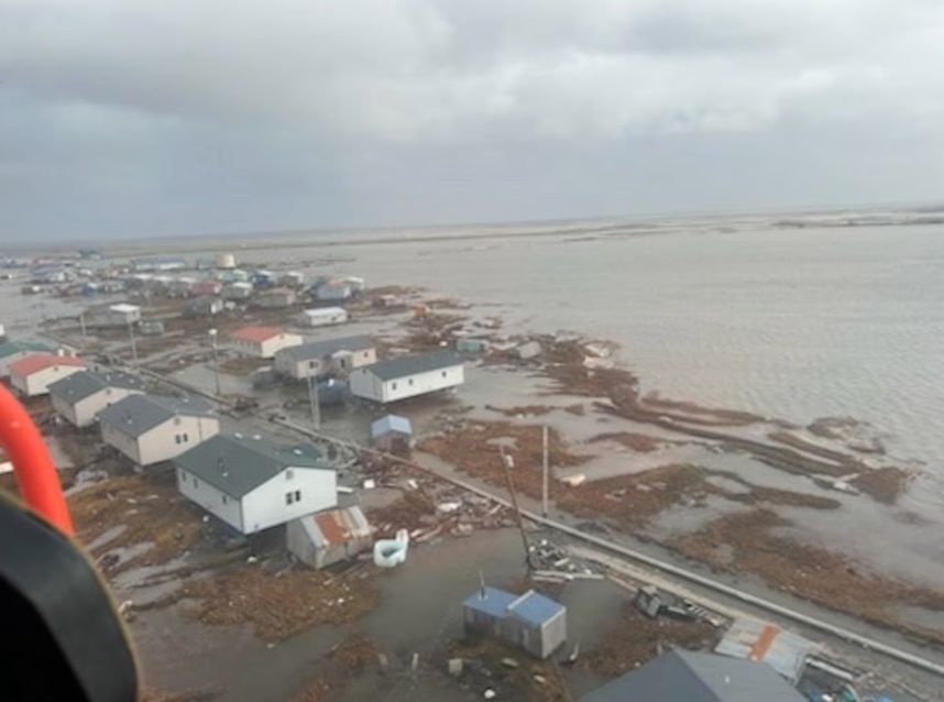
Native Alaskan communities reeling in wake of Typhoon Halong’s remnants » Yale Climate Connections
One town was almost completely inundated by its worst storm surge on record.
One life is lost, two are missing, and hundreds are in turmoil after the remnants of Typhoon #Halong got re-energized over unusually warm water. Its rare track pushed record storm surge into Native Alaskan communities along the remote SW coast. Here's my full look w/@drjeffmasters.bsky.social:
15.10.2025 20:51 — 👍 37 🔁 16 💬 0 📌 1
It continues... as of 6am on Monday:
- a 4th consecutive day with record-high dewpoint (57°F so far)
- 106 consecutive hours and counting with a 50°F+ dewpoint
13.10.2025 12:23 — 👍 22 🔁 5 💬 2 📌 0
Looks like Karen wins overall (not sure about advisories vs full HURDAT database). Per Michael Ferragamo:
“At 44.5°N, it is by far the northernmost forming system on record in the Atlantic Basin, surpassing the previous record of 42°N by UNNAMED 1952.”
Grace 2009: 41.2°N.
x.com/ferragamowx/...
10.10.2025 07:23 — 👍 5 🔁 1 💬 0 📌 0

Millions rely on dwindling Colorado River — but are kept ‘in the dark’ about fixes, critics say
Negotiations aimed at solving the Colorado River's water shortage are at an impasse. Environmentalists are criticizing a lack of public information about the closed-door talks.
The flow of the Colorado River has shrunk about 20%, and its depleted reservoirs continue to decline. But talks aimed at addressing the shortage are at an impasse, and environmental groups say the lack of information about the closed-door negotiations is a problem. www.latimes.com/environment/...
03.10.2025 17:18 — 👍 28 🔁 15 💬 1 📌 1
Several models are suggesting that Imelda and Humberto could merge over the North Atlantic, as shown in this HAFS forecast.
30.09.2025 18:07 — 👍 51 🔁 15 💬 9 📌 6

Announcement | Michael E. Mann
After a little less than a year in the position, I’ve decided to step down as Vice Provost for Climate Science, Policy, and Action (“VPC”) at […]
I've stepped down as Vice Provost at @upenn.edu to focus on public scholarship & outreach, which I feel is so important at this moment. I remain Presidential Distinguished Professor of Earth & Environmental Science & Director of @penncssm.bsky.social
Statement here: michaelmann.net/announcement/
30.09.2025 16:52 — 👍 358 🔁 56 💬 19 📌 4

Hurricanes Imelda and Humberto Lock Arms and Swing Away from the U.S.
Hurricane warnings issued for Bermuda as Imelda threatens a direct hit by late tomorrow into early Thursday
Imelda and Humberto are both hurricanes and less than 500 miles apart this morning. No two Atlantic hurricanes have been recorded so close together in the satellite era (since 1966). Imelda is Bermuda bound with a possible sting jet forming as it passes.
30.09.2025 15:22 — 👍 46 🔁 17 💬 2 📌 4
What happens when two tropical cyclones get "too" close to each other? It depends! There's often some rotational component of movement around a central point, but the strengths of each cyclone also make a huge difference. This week, #Imelda is set to be pulled into much stronger #Humberto's orbit.
29.09.2025 16:17 — 👍 18 🔁 6 💬 1 📌 0
“The [Department] has added “climate change,” “green” and “decarbonization” to its growing “list of words to avoid” at its Office of Energy Efficiency and Renewable Energy, according to an email issued Friday…
“The words on the DOE list are at the heart of EERE’s mission.”
28.09.2025 22:31 — 👍 24 🔁 15 💬 4 📌 1
:-(
28.09.2025 21:07 — 👍 17 🔁 5 💬 0 📌 0

Forecasts Trend Away from the Carolinas for Soon-to-Be Imelda
Heavy rains still forecast along the immediate Carolina coastal plain ahead of Imelda but landfall scenarios quickly fading
The big development since yesterday is forecast models falling in line with sharply turning future Imelda east and avoiding U.S. landfall. Still the U.S. isn't getting off scot-free. The latest details plus all the Category 5 Humberto stats and eye candy.
28.09.2025 14:58 — 👍 67 🔁 18 💬 1 📌 1
Man, this has been too true for too long. And beyond, "Okay, but get a heat pump" there's also "here's how to get a heat pump" and "here's a great installer."
28.09.2025 19:03 — 👍 59 🔁 13 💬 6 📌 1
It's been a decade since the U.S. Atlantic and Gulf coasts have gone this far into the season (Sep 28) without a hurricane landfall. A welcome respite!
28.09.2025 16:53 — 👍 34 🔁 9 💬 1 📌 0

Humberto hits Category 4, while The Bahamas and Southeast U.S. prep for the next storm » Yale Climate Connections
A tropical depression strengthening on Saturday could affect parts of the Southeast coast for several days.
Tropical Depression 9, now in The Bahamas, may dump 10-20" of rain somewhere close to the Southeast U.S. coast as a tropical storm or hurricane early next week. Onshore or offshore? That's one of many big questions in the air right now. Full update:
yaleclimateconnections.org/2025/09/humb...
27.09.2025 18:59 — 👍 32 🔁 12 💬 0 📌 2
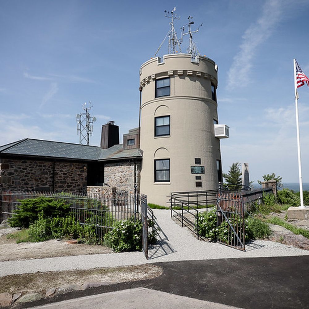
The Blue Hill Observatory is a national historic landmark & weather observation station located atop of Great Blue Hill in Milton, MA. Visitors hike to the site for tours & programs focused on weather, climate and the environment—bluehill.org
Associate Director, Program on Attribution Science @climatecentral.org
🌎 Into climate communications, circular economies, regenerative gardening, and land conservation.
Nonprofit, independent newsroom telling stories that matter for a dynamic, evolving state.
Support: http://coloradosun.com/support
Newsletters: http://coloradosun.com/newsletters
Climate scientist at CICERO, Oslo. I try to talk about climate science, but inevitably start talking about trains and bicycles if left unattended.
Enamored with all things ID! ID and HIV doctor. Animal and nature lover. Trying to do my part to save this planet! Will eat Peruvian food at any time.
Retired resource economist. I was the lead subject matter expert for energy-related CO2 for 20 years with the U.S. Energy Information Administration. Looking forward to communicating with experts on climate-related energy developments. PS Happily married.
Cannot jump high, highly motivated by clouds, vector enthusiast, fan of wilderness.
Erie, CO
Current reading: "Gulag Archipelago" (Solzhenitsyn), "Introduction to Quantum Mechanics" (Griffiths and Schroeter), “Heaven & Earth Grocery Store” (McBride)
Historian of environment/climate/disaster/cities/culture. SLC via AL and LA; UCLA Bruin. Book: The Frontier of Leisure: SoCal and the Shaping of Modern America; currently writing a book about climate and history in the US and North America.
Ph.D. candidate at Cornell University studying Earth’s regional hydroclimate
https://sites.google.com/cornell.edu/ynkuo-cornell/
Climate Scientist
Assistant Professor @ Cornell University
Chief Climate Scientist @ Polar Bears International
https://flaviolehner.eas.cornell.edu/
Known as @markemer on pretty much everything
Providing in-depth weather charts, statistics, and analysis. Stay informed about extreme weather events and global patterns. | Interested in Graphic Design 🌀
Climate impacts and adaptation for nature and people. Senior Scientist @ Climate Impacts Group & Univ. Director @ NW Climate Adaptation Science Center, U of Washington. Surfer/paddler. Settler on Coast Salish land. She/her. Personal account - views mine.
Climate reporter at The Atlantic. Into chemicals, climate, cool plants. THE LIGHT EATERS, a plant book, out from Harper Books. I'm zoeschlanger.99 on Signal
Climate journalist, teacher, professor of practice @uvaenvironment.bsky.social. Former WaPo climate writer. Views are my own. For my latest work: https://reportearth.substack.com/
University Lecturer of physical geography and environmental studies, climate science, California water resources, and advocate for Earth’s precious animal species.
Research Manager for @cclusa.org, environmental scientist, climate journalist for @climateconnections.bsky.social. Views my own.
Climate, pollution, clean/renewable energy
Stanford U Prof, Civil & Env Eng; Director, Atmos/Energy Program
Cofounder-Solutions Project; Appeared on Letterman
Testified Held v Montana
https://web.stanford.edu/group/efmh/jacobson/
Stanford.io/Jacobson