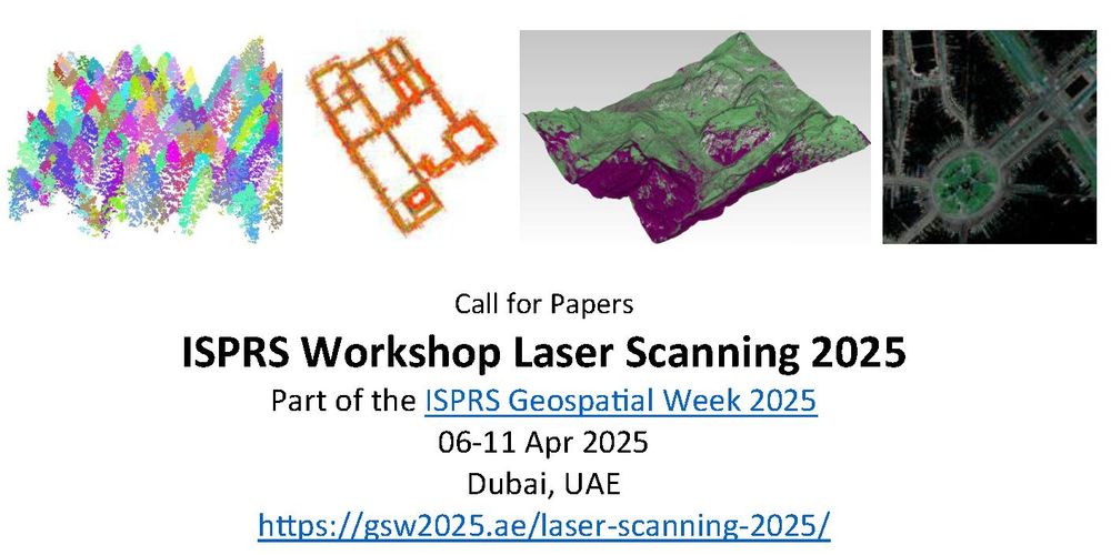
The 13th edition of the ISPRS Laser Scanning Workshop accepting extended abstracts until December 02, 2024. The workshop is part of ISPRS Geospatial Week 2025 Dubai. Submit abstracts and find more information at gsw2025.ae/laser-scanni...
27.11.2024 16:50 — 👍 4 🔁 2 💬 0 📌 0
🖖
23.11.2024 14:34 — 👍 1 🔁 0 💬 0 📌 0
There's now so many awesome #geospatial people here it's hard to keep track! 🤩
Here's a thread of some of my favourite starter packs so far - let me know what I've missed!
🛰️ Earth Observation & remote sensing: go.bsky.app/4PMRhNL
🌏 GIS: go.bsky.app/TJ7qQF6 @milos-makes-maps.bsky.social
(1/n)
19.11.2024 01:22 — 👍 164 🔁 65 💬 15 📌 15
Principal Research Scientist in Computer Vision at Naver Labs Europe
https://philippeweinzaepfel.github.io/
Professor, University Of Copenhagen 🇩🇰 PI @belongielab.org 🕵️♂️ Director @aicentre.dk 🤖 President @ellis.eu 🇪🇺 Formerly: Cornell, Google, UCSD
#ComputerVision #MachineLearning
University Professor of #Geography 🌍 #Geoinformatics. Head of 3DGeo Research Group (https://bsky.app/profile/3dgeohd.bsky.social) at Heidelberg University. Solutions for our digital and dynamic world. 3D geography matters.
prof for photogrammetry & geoinformatics #igeofhnw www.fhnw.ch/igeo; co-founder www.inovitas.ch; interests: 3d mobile mapping, uav, AR, robotics; my own views
Liesel Beckmann Distinguished Professor of Computer Science at Technical University of Munich and Director of the Institute for Explainable ML at Helmholtz Munich
Associate Professor, 3DAI Lab @ TU Munich
https://www.3dunderstanding.org/
a Ukrainian computer vision researcher escaping Twitter madness 😅
3D Computer Vision & Generative modelling
PhD student @ Inria Paris & @valeoai.bsky.social | Researcher @ Ukrainian Catholic University
https://t-martyniuk.github.io/
Prof ETH Zürich, Director Microsoft Spatial AI Lab, CV/ML/Robotics
research on computer vision, teaching, and movies.
tweets in TR, EN
Principal Scientist at Naver Labs Europe, Lead of Spatial AI team. AI for Robotics, Computer Vision, Machine Learning. Austrian in France. https://chriswolfvision.github.io/www/
International Relations Prof | TU Dresden | FU Berlin | UHH | IFSH | International Politics | 🇩🇪 Politics | 🇪🇺
Environmental remote sensing: microwaves and data-model fusion for vegetation, fires, water, carbon cycle, Prof @TUD Dresden University of Technology
Esri Director of Imagery and Remote Sensing. Pixel pusher. Community builder.
Associate Professor @UTKnoxville | Amazon Scholar | Creator of #geemap & #leafmap | Talk about #Geospatial #GeoPython #DataViz #GIS #FOSS #EarthEngine
Loves geodesy, LiDAR, photogrammetry and everything else related to geography. Nerding with Minecraft and frequent player of Crossy Road. Working public sector in my day job with all of the above. Father and husbond. Swiftie on the side. Copenhagen area.
Scientific Officer at the Copernicus Climate Change Service 🇪🇺 | Satellite Observations 🛰️ | Ocean and Cryosphere 🌊❄️🧊
Engineer @NASAJPL | PhD in #Geodesy | #InSAR #SAR #Tectonics #RemoteSensing enthusiast | Bilingual tweets (Turkish&English) | Statements and opinions are my own
Geophysics, geodesy, and random stuff. Deputy Director of Civil & Geospatial Engineering at Newcastle University but posting personally.
Nachrichten, Hintergründe und Debatten. Impressum: https://www.zeit.de/impressum