
After more than a year of writing, the two complementary books on (geo)scientific work with consideration of AI applications are now in print at SpringerNature!
mres.uni-potsdam.de/2026/01/13/c...

@martinhtrauth.bsky.social
Geoscientist | professor of paleoclimate dynamics at U Potsdam | MATLAB user since 1992 | author of six MATLAB- and Python-based textbooks on data analysis in earth and environmental sciences | views my own. http://mres.uni-potsdam.de
After more than a year of writing, the two complementary books on (geo)scientific work with consideration of AI applications are now in print at SpringerNature!
mres.uni-potsdam.de/2026/01/13/c...

Wikipedia, celebrating its 25th birthday, is facing numerous challenges: dwindling number of contributors, the struggle against AI, and the exploitation of AI chatbots. #wikipedia #ai
mres.uni-potsdam.de/2026/01/23/h...

Artificial intelligence has revolutionized the way geoscientific information is collected, processed, and presented. Having authored two editions of a book on this subject, it was time for a change. This month, I'm thrilled to announce that I'll be submitting two new books to SpringerNature!
13.01.2026 07:43 — 👍 7 🔁 3 💬 0 📌 0
📢 Workshop CALL: Deep CHB (Addis Ababa, Ethiopia)
Deep Chew Bahir Drilling Project
WHEN 📆 June 30th – July 3rd, 2026
CALL ▶️ www.icdp-online.org/fileadmin/Ne...
MORE INFO ℹ️ www.icdp-online.org/all-events/d...
Thanks, Marta. Warm regards from Potsdam! 🙂
18.11.2025 12:56 — 👍 1 🔁 0 💬 0 📌 0
AI changed everything, also the way of collecting, processing and presenting geoscientific information. Having published two editions of a book on the topic, it was time for a change. And two new books.
mres.uni-potsdam.de/2025/11/11/c...


The #Python and #MATLAB Recipes for Earth Sciences books are back in the top 100 at Springer Earth and Environment, the last two editions each. Thank you all for continuing to buy the books, even though they can usually be downloaded from university libraries!
www.springernature.com/de/bookselle...
Well, judging by what I find on your website, you've found a good way to do interesting things without using mathematics. Maybe image processing would be something for you, for your beautiful photos of old fossils? Unfortunately, I can't stop giving advice 😉
09.11.2025 12:31 — 👍 1 🔁 0 💬 1 📌 0Yes, indeed, student numbers continue to decline, both in the geosciences and in the natural sciences in general, even climate sciences. In times when we have to spend billions on defense, we are looking even more closely at whether we still need this or that.
09.11.2025 10:03 — 👍 1 🔁 0 💬 0 📌 0Actually, I was never good at math either. My salvation was Fortran77 in a course on numerical methods in 1987, and later MATLAB in 1992. For me, a line of computer code is much easier to understand than equations. I started writing "how to ..." files, later became the recipes books.
09.11.2025 09:51 — 👍 6 🔁 0 💬 1 📌 0Fixed – thanks!
08.11.2025 18:20 — 👍 1 🔁 0 💬 0 📌 0
More than 30 years ago, I began teaching courses on data analysis in the earth sciences. 20 years ago, I started thinking about writing textbooks. Now there are six textbooks and many different course formats for you. Here are the options for you:
mres.uni-potsdam.de/2025/10/15/o...

The photo shows ~2500-year-old rock art on a basalt cliff in the southern Turkana Basin, Kenya, a good example of sustainability.
Young people—as I was back then—do not really appreciate how quickly their valuable data, painstakingly created graphics, and carefully crafted texts can become unreadable. Here are a few thoughts on this and a recommendation:
mres.uni-potsdam.de/2025/11/08/s...
Oh yes, absolutely. We had remote sensing specialists trained in geodesy who were told by a geologist that this version of the hyperspectral satellite image showed the volcanoes particularly well. Which volcanoes, asked the geodesists. That's why remote sensing is combined with field courses.
08.11.2025 10:54 — 👍 9 🔁 0 💬 0 📌 0I still had two semesters of paleontology as a compulsory subject, two more semesters as an elective, which had completely disappeared at our university. Traditional field courses that are not consistently linked to remote sensing and digital data collection must also be phased out.
08.11.2025 10:12 — 👍 2 🔁 1 💬 0 📌 0
Unfortunately, in many courses in geosciences worldwide, university-level mathematics and computational geosciences is not included, as my experience from processing this year’s masters applications suggests.
mres.uni-potsdam.de/2025/11/07/h...

If you are looking for an international #Master's program in #Geosciences without tuition fees, with many courses in modern data analysis, remote sensing and geoinformation systems, the U Potsdam is the right place for you! Please visit the following website for more information:
lnkd.in/de8RgJd5

Detecting, measuring and classifying #transitions in #climate time series is an important application in modern time series analysis. Three methods are presented here, taken from my #Python and #MATLAB Recipes for Earth Sciences (2024, 2025) books:
mres.uni-potsdam.de/2025/10/31/a... #geosciences

Cretaceous #echinoid fossil, island of Rügen, Germany. Stack of five images, shot with a Nikon Z fc with a Nikkor Z MC 50 mm 1:2.8, auto focus, aperture 29, exposure time 1.3 s, and ISO 400. Size of the fossil is about 3 cm.
Cretaceous #echinoid fossil, island of Rügen, Germany. Stack of five images, shot with a Nikon Z fc with a Nikkor Z MC 50 mm 1:2.8, auto focus, aperture 29, exposure time 1.3 s, and ISO 400. Size of the fossil is about 3 cm. #FossilFriday
31.10.2025 09:22 — 👍 17 🔁 3 💬 0 📌 0

Hungry bumblebees crowd together, sometimes three at a time, on the last nodding thistle (Carduus nutans) on the dry grassland south of Potsdam's Südforst forest. Germany, on a sunny October day, shot with a Nikon Z fc with a Nikkor Z MC 50 mm 1:2.8.
24.10.2025 12:38 — 👍 6 🔁 0 💬 0 📌 0

On April 1, 2022, a satellite was launched as part of the German EnMAP program to collect hyperspectral satellite data, which can be obtained free of charge. Here are MATLAB script to display the spectra of single pixels and flatfields:
tinyurl.com/3atmxkss
tinyurl.com/55vyu6e9

Display of mineral spectra from the USGS spectral library.
The USGS spectral library is an important database of mineral spectra, which is used as a reference for the spectrometric determination of unknown substances. Here is a simple #MATLAB program that can be used to load and display the spectra of several minerals.
mres.uni-potsdam.de/2025/10/16/i...

Am 26. September 2025 ist wieder Kinder-Universität an der Universität Potsdam. Ich bin wieder mit zwei Vorlesungen dabei, "Knochenjob in Ostafrika–Unterwegs auf den Spuren der ersten Menschen" und "Was war los im nördlichen Afrika, bevor es Pyramiden gab?".
www.uni-potsdam.de/de/medieninf...

Today marks the start of the 60th compact course based on my textbooks #MATLAB Recipes for Earth Sciences, 6th Edition (Springer 2025) and #Python Recipes for Earth Sciences, 2nd Edition (Springer 2024). I am looking forward to this new round of teaching online!
mres.uni-potsdam.de/2024/10/23/o...

Artificial neural networks (ANNs) have been used for quite some time to identify, for example, flowers in easy-to-use apps on smartphones. Here's an #ANN with backpropagation in 6 steps, now with both #MATLAB and #Python code:
mres.uni-potsdam.de/2025/09/08/a...

Multispectral imaging of a Permian druse showing eight different wavelengths in the range of 450 nm and 850 nm in pseudocolor plots.
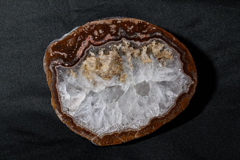
Agate druse, basalt, "melaphyr", 290 million years, Permian, Waldhambach, Germany, shot with a Nikon Z fc with a Nikkor Z MC 50 mm 1:2.8, auto focus. Width of the druse is about 10 cm.
Multispectal imaging captures images across multiple spectral bands. Here is a #MATLAB example using #MAPIR cameras where eight different spectral bands in visible light and near infrared show differences in a rock sample that are invisible to the human eye.
tinyurl.com/bd9by86r
#geoscience

Thanks to the ongoing support of MathWorks Inc. through their Curriculum Development Program, I was able to purchase two more spectral cameras. Here is an example of how to import and process the images of an agate druse sampled from a Permian basalt in #MATLAB:
tinyurl.com/54umubv4
#geoscience

Due to two cancellations, we have reopened the registration portal for you! As always, it's about 15-20 people online, lectures and live coding sessions, prerecorded on the course website and you can work on exercises and an individual project to get up to six credit points!
shorturl.at/VzWLn

KIND workshop last week in Potsdam (Germany): 65 scientists from all over the world gathered in Potsdam discussing ideas for scientific drilling of Lake Kinneret to address question of paleoclimate variability and its link to human evolution ℹ️ www.icdp-online.org/projects/by-...
14.07.2025 07:37 — 👍 4 🔁 3 💬 0 📌 0
As part of upcoming ICDP KIND workshop this weekend on Lake Kinneret Drilling, I will give a presentation on climate time series analysis, methods, and applications. I have compiled a list of courses, books, and papers by us during the last decade:
mres.uni-potsdam.de/2025/07/09/r...