Olin Asiastudio-podcastin vieraana juttelemassa mahdollisesta Atlantin kiertoliikkeen romahduksesta ja sen vaikutuksista. Paljon asiaa, eikä kaikkea tietenkään muistanut edes kertoa!
www.youtube.com/watch?v=lnRC...

@mikarantane.bsky.social
Researcher at the Finnish Meteorological Institute. Climate change, extreme weather and attribution of extreme events. PhD in meteorology from the University of Helsinki.
Olin Asiastudio-podcastin vieraana juttelemassa mahdollisesta Atlantin kiertoliikkeen romahduksesta ja sen vaikutuksista. Paljon asiaa, eikä kaikkea tietenkään muistanut edes kertoa!
www.youtube.com/watch?v=lnRC...

Here are
the press release on the retraction of one our Nature papers
www.pik-potsdam.de/en/news/late...
some explanations
www.pik-potsdam.de/en/news/late...
the journal's comment
www.nature.com/articles/s41...
Please note:
The fact that climate change causes huge economic damages is not disputed..

Thanks for asking. I think it is based on kriging interpolation. Full documentation is here: agupubs.onlinelibrary.wiley.com/doi/full/10.1002/2015JD024651
03.12.2025 07:58 — 👍 4 🔁 0 💬 1 📌 0
Marras-joulu 2006 on nykyään Kaisaniemen aikasarjan 7. lämpimin, mutta oli silloin tapahtuessaan 3. lämpimin! Eli en ihmettele ratkaisuasi :D
01.12.2025 13:57 — 👍 5 🔁 0 💬 1 📌 0
Jan-Nov mean temperature in Helsinki Kaisaniemi in 1845-2025.
Helsinki, Finland, is currently on track for the 2nd warmest calendar year on record, trailing only 2020 📈🌡️
To avoid this, December would need to be more than 2 °C colder than average, a scenario that seems unlikely at this point (based on sub-seasonal forecasts).

Screenshot of article "Farewell from the outgoing Co-Editor-in-Chief"
I've had the privilege of being Co-Editor-in-Chief of @rmets.org Weather since September 2020, first alongside @eddywx.bsky.social and then Regan Mudhar. Now please join me in welcoming Ben Maybee as the next Co-EiC! rmets.onlinelibrary.wiley.com/doi/10.1002/...
01.12.2025 09:17 — 👍 13 🔁 2 💬 1 📌 0
More in Finnish in @suomenluonto.bsky.social blog: suomenluonto.fi/marraskuun-l...
01.12.2025 10:35 — 👍 8 🔁 0 💬 1 📌 0
Measured temperature anomaly in Finland in November 2025, based on FMI ClimGrid.

Scatterplot on Helsinki temperature anomaly against Sodankylä temperature anomaly. November 2025 falls outside the previous observations.
The temperature anomaly difference between the south and north was exceptionally large in November: it was the first occurrence when the anomaly in Sodankylä was < -2 °C and in Helsinki > +2 °C during the same month!
Records kept since 1901.

Kiitos, toki on tiedossa että lämpeneminen on kiihtynyt viime vuosikymmeninä, ja sen myös uutisessa käytetyt CMIP6-ilmastomallit ennustaa.
www.theclimatebrink.com/p/the-great-...
Ei ole malliennusteiden osalta muuttunut oikeastaan mitenkään. Seuraavan sukupolven ilmastomallisimulaatioita (CMIP7) ei ole vielä julkaistu. Jos halutaan tehdä projektio esim. hellepäivien tai lumen määrästä, niin CMIP6-mallit + kaksi skenaariota (SSP2-4.5 ja SSP5-8.5) on mielestäni hyvä valinta.
01.12.2025 06:54 — 👍 1 🔁 0 💬 2 📌 0Käytetyt ennusteet perustuivat samoihin CMIP6 ilmastomalleihin ja skenaarioihin, joihin perustui tuorein IPCC:n AR6-raportti. Se nimenomaa kuvaa ilmastotieteen näkemystä. Mitä ilmastomallia tai skenaariota olisit itse käyttänyt?
01.12.2025 06:01 — 👍 1 🔁 0 💬 3 📌 0Kiitos vinkistä, pitääkin kuunnella kun näitä samoja aineistoja tulen itsekin käyttämään tutkimuksissa tulevaisuudessa.
01.12.2025 05:26 — 👍 1 🔁 0 💬 0 📌 0Joo. Voi olla että pitää tehdä valintoja sen suhteen mitä vaikutuksia voi yhdessä artikkelissa käsitellä järkevästi. Ehkä nuo tekoälyvisualisoinnit olivat tässä jutussa se uutuusarvo.
30.11.2025 09:54 — 👍 2 🔁 0 💬 0 📌 0Tämän hetken päästövähennystoimien ja -lupausten perusteella ollaan menossa kohti 2,7 asteen lämpenemistä. Sitä nuo visualisoinnit kuvasivat hyvin.
30.11.2025 09:45 — 👍 3 🔁 0 💬 1 📌 0Mutta tuollahan oli juurikin hyvin kattavasti haastateltu eri alojen asiantuntijoita jotka kertoivat millaisia vaikutuksia säiden muuttumisella on? Eli ei pelkästään meteorologiaa vaan myös niitä konkreettisia vaikutuksia.
30.11.2025 08:54 — 👍 5 🔁 0 💬 2 📌 0Siinä oli käytetty kahta eri päästöskenaariota, joista toinen (SSP2-4.5) on linjassa nykyisten päästövähennyslupausten kanssa, ja toinen (SSP5-8.5) on sitten äärilaita, joka vain kertoo miltä kaikelta voidaan välttyä jos hillintää ei tehdä.
30.11.2025 08:30 — 👍 1 🔁 0 💬 1 📌 0Totta, nuo tekoälyvisualisaatiot toivat kivasti konkretiaa.
30.11.2025 08:28 — 👍 2 🔁 0 💬 1 📌 0Just a small correction: FMI calculated the underlying projections from pre-existing CMIP6 simulations. Yle made the visualisations.
30.11.2025 08:27 — 👍 2 🔁 0 💬 0 📌 0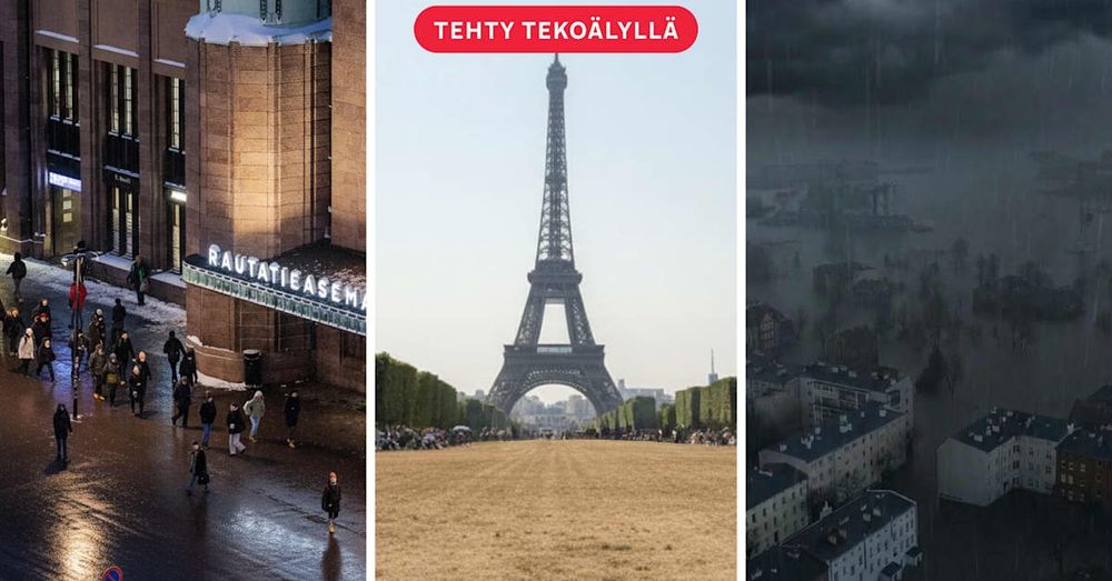
Näin Euroopan ilmasto voi muuttua 2100 mennessä
yle.fi/a/74-2019207...
Hieno artikkeli tehty FMI-Yle yhteistyöllä. Laskin Ylelle ilmastomalliennusteet pyynnöstä.
Ehkäpä? en oikein osaa sanoa, miksiköhän se on sitten jäänyt kirjoittajilta huomioimatta.
27.11.2025 10:29 — 👍 2 🔁 0 💬 0 📌 0Technically, it may happen tomorrow, but we will know it only afterwards because it is so close to the threshold.
27.11.2025 09:30 — 👍 2 🔁 0 💬 1 📌 0
Screenshot of the figure 4 of the paper. Time series of reconstructed temperature anomalies in southern Greenland in 1500-2023.
500-year paleoclimate record inferred from Greenland Juniper wood contextualizes current climate warming
"By providing a 500-year context for long-term climate variability, it has been confirmed that the observed recent warming is unprecedented"
www.nature.com/articles/s41...

Kaamos alkoi Utsjoella, mutta Inarissa vielä paistaa.
Ukonjärvi -27 🌞
Wow, amazing photos! Great that you got there safely!
25.11.2025 09:53 — 👍 1 🔁 0 💬 0 📌 0
The importance of weather and climate science in the insurance industry
"Insight" article in @rmets.org Weather from @mattpriestley.bsky.social & @hcbloomfield19.bsky.social
doi.org/10.1002/wea....

November-to-date temperature anomalies in FInland. It has been 1-3 °C warmer than normal month in the south and 1-4 °C colder than normal month in the north, so the map has yellow/orange colors in the south and blueish colors in the north.
November-to-date temperature anomalies in Finland.
It is somewhat rare to have such a strong contrast between south and north: usually temperature anomalies are well correlated over large (~1000 km) distances.
🚨New paper on heatwaves in a net zero world 🚨
In our study, led by @sarahinscience.bsky.social, we find that the intensity, length and frequency of heatwaves do not return to pre-industrial levels under net zero - and in many regions barely improve at all.
iopscience.iop.org/article/10.1...
No, this is just natural weather variability. As you can see from the post, the lowest daytime temperatures have been generally very high before this event which started mid-November.
21.11.2025 13:47 — 👍 3 🔁 0 💬 0 📌 0
Extremely cold conditions have prevailed under surface inversion in Lapland now for several days. Some stations have not risen above -25 °C even in the daytime, which is exceptional for the time of the year.
For example, Kittilä Lompolonvuoma *highest* today is -27.1 °C.
Can simple circulation analogues detect observed changes in extreme rainfall?
In many cases, no. Rainfall is too complex and circulation alone cannot predict it. 🧵1/2
🌧️ New paper 🌧️
iopscience.iop.org/article/10.1...