This chart shows the proportion of Blacks in total population of the US is compared from 1800 (one-fifth, 20%) to 1890 (one-eighth, 12.5%) The sizes are shown as superimposed maps: a land within another land.
09.02.2026 13:34 — 👍 0 🔁 0 💬 0 📌 0
@ajstarks.bsky.social
Art+Code, Developer/Designer, tool maker. Visualization, Go Programming Language.
This chart shows the proportion of Blacks in total population of the US is compared from 1800 (one-fifth, 20%) to 1890 (one-eighth, 12.5%) The sizes are shown as superimposed maps: a land within another land.
09.02.2026 13:34 — 👍 0 🔁 0 💬 0 📌 0
This chart of small multiples, compares the population of Blacks in America with various countries (Spain, Australia, Norway/Sweden, Belgium, the Netherlands, Switzerland, Hungary, Bavaria, and England).
09.02.2026 13:33 — 👍 0 🔁 0 💬 1 📌 0
Yet another way to the distribution of Black people in America, this chart uses number of people per square mile, ranging from 15-15 in southern states like Georgia and Mississippi, to less than 1 person/square mile in the west and upper mid-west.
09.02.2026 13:33 — 👍 0 🔁 0 💬 1 📌 0
Serving as the introductory display, this chart shows the full Du Bois color palette. The chart includes bi-lingual text, a map of the Black population in the US, and a familiar pie chart showing professions in the population.
09.02.2026 13:32 — 👍 0 🔁 0 💬 1 📌 0
Land ownership was an indicator of economic and social development, as depicted in this choropleth of the state of Georgia shows.
09.02.2026 13:32 — 👍 0 🔁 0 💬 1 📌 0
The migration to and from Georgia to other the states of the US is shown in this visual. The map shows how the state with a large Black population originated, and where they were dispersed to.
09.02.2026 13:31 — 👍 0 🔁 0 💬 1 📌 0
"Negro Population of Georgia by County", is a choropleth map with a alternating left-right pattern, comparing the population of Black Georgians in the years 1870 and 1890. Note the decrease of lightly populated areas, with the heavily populated areas in red shifting west.
09.02.2026 13:31 — 👍 0 🔁 0 💬 1 📌 0
This chart shows the Black population in the Georgia counties ranges from over 30,000 in the south east to under 1000 in the north and southern portions of the state. The most prevalent category is in the 5-10,000 Black people distributed throughout the state.
09.02.2026 13:30 — 👍 0 🔁 0 💬 1 📌 0
This map of the US shows the distribution of Black people at the turn of the twentieth century. Ranging from 75,000 and over in Georgia to less than 10,000 in the western states.
09.02.2026 13:30 — 👍 0 🔁 0 💬 1 📌 0
"The Georgia Negro, A Social Study" shows the transatlantic slave trade, with routes from Europe, Africa, the Americas and the Caribbean, highlighting Georgia. This visual contains Du Bois' famous assertion: "The problem of the 20th century is the problem of the color line"
09.02.2026 13:29 — 👍 0 🔁 0 💬 1 📌 0
Welcome to #DuboisChallenge2026 where the #dataviz community is encouraged to re-create visuals from the Paris Expo of 1900. This years theme is "Maps". This thread will introduce each image (see: github.com/ajstarks/dub...)
09.02.2026 13:28 — 👍 2 🔁 1 💬 1 📌 0
The #DuboisChallenge2026 will kick off on February 9. Here is a peek at the visuals for this year, the theme is Maps:
03.02.2026 17:16 — 👍 0 🔁 0 💬 0 📌 0
#genuary2026 #genuary13, Self Portrait with giftsh
31.01.2026 18:45 — 👍 1 🔁 0 💬 0 📌 0
#genuary2026 #genuary21 Bauhaus (Wilhelm Wagenfeld table lamp)
31.01.2026 18:42 — 👍 1 🔁 0 💬 0 📌 0When machines and computers, profit motives and property rights, are considered more important than people, the giant triplets of racism, extreme materialism, and militarism are incapable of being conquered. --Martin Luther King, "Beyond Vietnam -- A Time to Break Silence" #MLK
19.01.2026 15:48 — 👍 1 🔁 0 💬 0 📌 0
World map showing the countries (light blue) and cities (red dots) visited by W.E.B Du Bois, 1882-1961
The Travels of W.E.B. Du Bois, 1882-1961
13.12.2025 18:39 — 👍 1 🔁 0 💬 0 📌 0
Newark
12.11.2025 13:59 — 👍 1 🔁 0 💬 0 📌 0
Updated to #Fedora 43:
29.10.2025 00:50 — 👍 1 🔁 0 💬 0 📌 0
Last four watched: Highest to Lowest, Warfare, One Battle after Another, Punch Drunk Love
#LetterboxdFriday #LastFourWatched 🍿
#filmsky -- Highest to Lowest, Warfare, One Battle after Another, Punch Drunk Love

Plainfield, NJ
01.10.2025 03:07 — 👍 2 🔁 0 💬 0 📌 0
Map of the US, Canada, and Mexico with Atlantic and Pacific Oceans labeled along with a path from New York to Los Angeles

A map of the ancient world, with Italy, Greece, Turkey, Egypt, Iraq, Libya, Tunisia labeled, along with cities

World map with blue oceans, white land masses, and lat/long scales

Map of Europe showing Allied and Axis countries with key cities.
decksh now does goegraphic functions: regions, borders, labels, paths, images:
30.09.2025 15:54 — 👍 2 🔁 0 💬 0 📌 0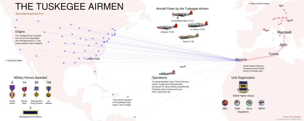
An updated overview of the Tuskegee Airmen, showing geographic details (origins, bases, sites of aerial victories, awards, aircraft flown, and organization. (this highlights the Geographical features of decksh) speakerdeck.com/ajstarks/the...
26.08.2025 14:52 — 👍 0 🔁 0 💬 0 📌 0I have not seen any of the other Sorrentino works, what do you recommend?
and, yes, the piece played in one of the last scenes and the closing credits of Great Beauty is very, very good.
Yep!
07.07.2025 19:10 — 👍 1 🔁 0 💬 1 📌 0
Recent viewing: Parthenope, Hand of God, Great Beauty, and Last Showgirl #letterboxed #lastviewed
06.07.2025 22:14 — 👍 1 🔁 0 💬 1 📌 0
I'm slow to the party but just discovered I got a mention in @ajstarks.bsky.social recap of #DuboisChallenge2025 - what a treat! 📊
Lots of beautiful work highlighted in this deck, worth a look.
speakerdeck.com/ajstarks/num...

NBA Final, Game 7, Scorediff chart
25.06.2025 23:26 — 👍 0 🔁 0 💬 0 📌 0
Happy Juneteenth
19.06.2025 15:40 — 👍 2 🔁 1 💬 0 📌 0Nice to see the success #5yearsoftailscale
18.06.2025 14:35 — 👍 0 🔁 0 💬 0 📌 0

🎉We're celebrating 5 years of Tailscale! Read on for key lessons learned from half a decade of simplifying secure networking + enter to win one of five lifetime Personal Plus plans! Repost to win
👉 Read more tailscale.com/blog/5-thing...
🗒️ Full rules here - tailscale.com/blog/5-thing...