Here are my top 5 geospatial Python libraries. Which would you add?
27.06.2025 16:05 — 👍 3 🔁 1 💬 0 📌 0
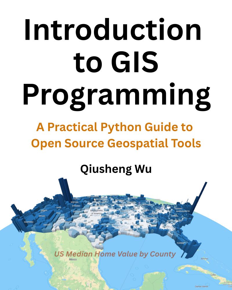
📣 Exciting News! I'm thrilled to announce the release of my new book: Introduction to GIS Programming: A Practical Python Guide to Open Source Geospatial Tools!
✨ What’s Included:
All code examples are freely available.
Access to 26 hours of free video tutorials to complement your learning.
25.06.2025 11:57 — 👍 44 🔁 10 💬 2 📌 1
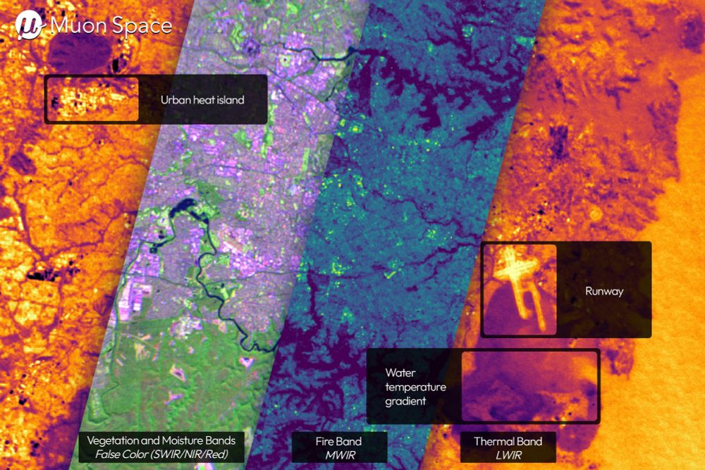
Composite of thermal, midwave, shortwave, and near infrared images of Sydney Australia showing variations in temperature.
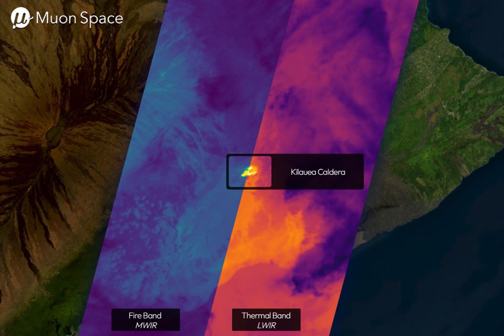
Composite of thermal and midwave infrared images of Kilauea Volcano showing the heat signature of the camera lava flows.
First light of thermal images from Muon Space/FireSat looking good: www.muonspace.com/press/muon-s...
🛰️🗺️
26.06.2025 21:04 — 👍 9 🔁 1 💬 1 📌 0
SQLRooms
Build powerful analytics apps with DuckDB
Has anyone tried out the new SQL Rooms functionality from @foursquarecom.bsky.social? Looks pretty cool I must say!
sqlrooms.org
27.06.2025 14:10 — 👍 2 🔁 0 💬 0 📌 0
If you’ve ever wanted to learn this stuff, but don’t know where to start or want to have something to show for your skills.
Start small. Learn fast. Build modern spatial skills.
Brick E1 is live now.
Link + early bird discount in the next post 👇
27.06.2025 03:49 — 👍 0 🔁 0 💬 1 📌 0
E1 is part of a full “Data Engineering for Spatial” track: file formats to Apache Iceberg, to Airflow workflows, to CI/CD for spatial pipelines.
Each brick is practical. Stackable. And career-relevant.
27.06.2025 03:49 — 👍 0 🔁 0 💬 1 📌 0
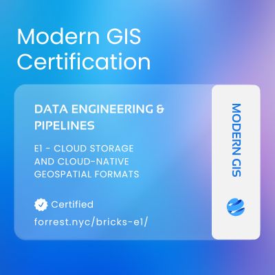
Certification badge for a Modern GIS course focused on Cloud-Native Geospatial data and formats
The Brick runs in a Gitpod notebook (zero setup) or locally if you want.
Watch the videos, run the code, push to GitHub, and the grader gives you a grade.
If it all checks out? You earn a badge.
A real, verifiable badge you can share anywhere.
27.06.2025 03:49 — 👍 0 🔁 0 💬 1 📌 0
You’ll learn how to:
Read & write Cloud-Optimized GeoTIFFs
Work with GeoParquet for scalable vector storage
Use AWS S3 to put this data in the cloud
Understand why these formats matter, even locally
27.06.2025 03:49 — 👍 0 🔁 0 💬 1 📌 0
I've been down this road so I am trying to build something new:
✅ 4–6 hour mini-courses
✅ Auto-graded via GitHub
✅ Skills-first, backed by OpenBadges
✅ Stacked into career-focused tracks
The first stack of four focuses on Geospatial Data Engineering. Here is what is in the first "brick" or course:
27.06.2025 03:49 — 👍 0 🔁 0 💬 1 📌 0
The truth is, you don’t need a master’s degree to learn modern GIS.
You need small, focused learning units. You need real-world projects. You need proof of skills you can show.
And you need a path to do so, not just scattered tutorials.
27.06.2025 03:49 — 👍 0 🔁 0 💬 1 📌 0
The gap is widening too. Cloud-native geospatial is moving fast and it is an in demand skill
Most GIS programs don't cover them. Most online courses barely scratch the surface. Most professionals are left to figure it out on their own.
27.06.2025 03:49 — 👍 0 🔁 0 💬 1 📌 0
IMO this leads to a mismatch in hiring where job postings ask for everything and the kitchen sink, the full stack geospatial expert, when that isn't the reality.
27.06.2025 03:49 — 👍 0 🔁 0 💬 1 📌 0
The options aren't great if you want to quickly learn a new technology and prove that you know it.
Traditional education usually is behind, and that leaves you sifting through blog posts and online tutorials.
27.06.2025 03:49 — 👍 0 🔁 0 💬 1 📌 0
For years I’ve watched smart and motivated GIS professionals struggle to keep up with modern tools.
Not because they’re not capable. But because the way we teach GIS hasn’t evolved with the technology.
27.06.2025 03:49 — 👍 0 🔁 0 💬 1 📌 0
Okay that helps. A lot of what I see online and LinkedIn looks like really cool 3D viewers but my assumption was that they can account for and work with different scenarios and show what it would look like. Or at least that is the goal which it sounds like what you are saying - thanks!
29.01.2025 19:12 — 👍 1 🔁 0 💬 0 📌 0
That’s my understanding too. But does it add anything beyond just beyond the visual aspect?
29.01.2025 16:52 — 👍 0 🔁 0 💬 1 📌 0
So I have a question - can you all help me understand the need or use cases for digital twins? Most of the ones that I see are 3D representations of a city or place, which is cool but what are they used for? And how can they create value?
29.01.2025 15:13 — 👍 1 🔁 0 💬 1 📌 0
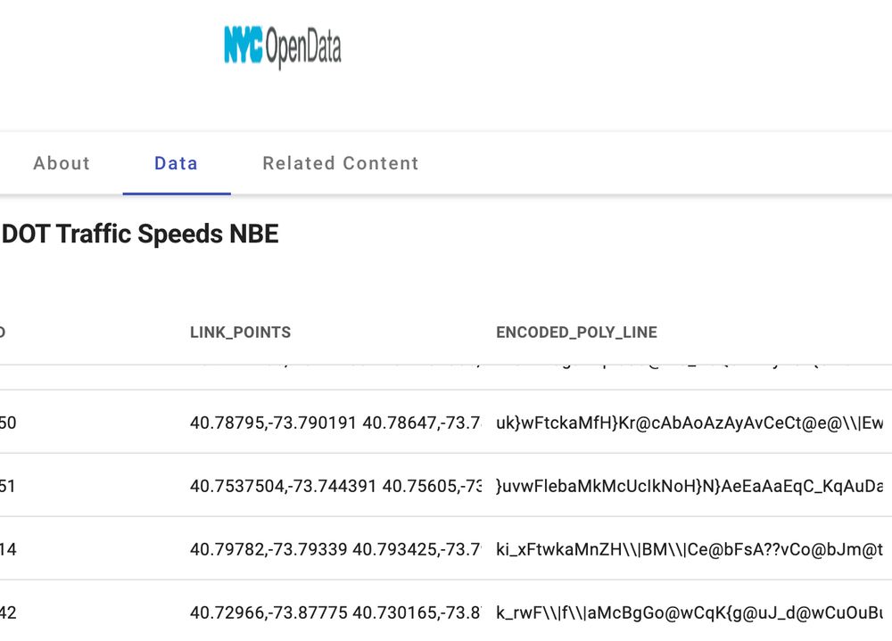
Encoded polylines and lat/lng pairs in reverse order in a STRING! Not cool NYC Open Data.
08.01.2025 13:49 — 👍 2 🔁 0 💬 0 📌 0
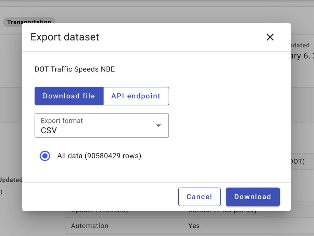
I wonder how far we can push NYC Open Data...
06.01.2025 23:29 — 👍 5 🔁 0 💬 1 📌 0
3️⃣ Earth Observation Services - The boom in high-resolution satellite and drone data is transforming many different industries. EO platforms are democratizing access to actionable insights, enabling businesses to monitor, predict, and act with precision.
13.12.2024 17:34 — 👍 2 🔁 0 💬 0 📌 0
2️⃣ Agriculture - Precision agriculture is revolutionizing how we grow food. With drones, sensors, and increasingly better satellite imagery, farmers can optimize yields, reduce waste, and adapt to climate challenges.
13.12.2024 17:34 — 👍 2 🔁 0 💬 1 📌 0
1️⃣ Climate Risk - As climate change intensifies, geospatial tools are becoming essential for assessing and mitigating risks like floods, wildfires, and rising sea levels. Industries like insurance, ESG reporting, and real estate are leveraging predictive models and real-time analytics.
13.12.2024 17:34 — 👍 1 🔁 0 💬 1 📌 0
🔮 What do you think the next year will hold for geospatial? Which areas are going to grow the most? What new companies are going to emerge? Here are my top 3 (share yours as well!):
13.12.2024 17:34 — 👍 5 🔁 1 💬 1 📌 1
They don't today but I could do it I think...
09.12.2024 20:44 — 👍 0 🔁 0 💬 1 📌 0
Esri is showing signs of progress, but their journey toward modern GIS is far from complete. They must fully embrace cloud-native and open systems to lead the future.
09.12.2024 20:43 — 👍 1 🔁 0 💬 0 📌 0
🌐 Modern GIS requires:
Scalability
Interoperability
Modularity
Esri could leverage their strengths as a connector in the geospatial ecosystem, like their existing connections with tools like Redshift, BigQuery, and Snowflake.
09.12.2024 20:43 — 👍 0 🔁 0 💬 1 📌 0
📦 Esri’s containerization efforts align with cloud-native principles, but there’s a bigger challenge: rethinking their core architecture to fully embrace modern GIS.
09.12.2024 20:43 — 👍 0 🔁 0 💬 1 📌 0
To clarify:
Cloud-enabled = Legacy apps migrated to the cloud.
Cloud-based = Designed for better cloud efficiency.
Cloud-native = Built for the cloud, leveraging full scalability and cost efficiency.
09.12.2024 20:43 — 👍 0 🔁 0 💬 1 📌 0
ArcPy still relies heavily on traditional Esri tools, creating bottlenecks in scalability and flexibility. And Esri Server falls short of true cloud-native capabilities.
09.12.2024 20:43 — 👍 0 🔁 0 💬 1 📌 0
Geographer and Geospatial professional! Interested in all things GIS and Remote Sensing. Transit planning, Maps, indoors positioning system.
GeoMeetup Organizer and author of Python for ArcGIS Pro
Conservation Geographer @uni-hamburg.de. Land system science🏔️ | Conservation science🐼 | Protected area🏞️ | Spatial analysis🛰️
Geographer, cartographer & developer for the open science in archaeology. I run https://Mapstodon.Space, the maps & geo Mastodon instance.
https://mapper.fr
French and main website: https://geotribu.fr
English blog: https://blog.geotribu.net/
#OSGeo #FOSS4G #opensource #GIS #GeoRDP #QChat
Publishing geospatial open data efficiently using GeoNetwork, GeoServer and Bridge. We offer software, services, cloud hosting, support and consulting
A mapish developer working at GeoCat. Active with the OSGeo and LocationTech communities working on a wide range of free and open source geospatial goodness!
Riding some bikes, writing some code, still making Geocode Earth after 7 years
Remote Sensing expert @planetlabs #forest🌳 #LUC #carbon #supplychain | Geospatial Rising Star 2022 | @GoogleDeveloperExpert #EarthEngine, co-founder of geoinclusion and member of @rsategroup #earthobservation #Amazon #Cerrado
PhD candidate | Self-supervised DL | Earth Observation | Generative AI |
earthbytelab.com
#geospatial #remotesensing #earthobservation #datascience #earthengine
Research scientist at Aalto University, interested in environmental modelling, hydrology, #Mekong, data scarcity, spatial analysis. In my spare time I'm a cartographer. And at other times, a #randonneur.
Self-employed software engineer and consultant working on geospatial ☁ solutions. openEO, STAC and cloud-native geo. Also fixing my parents' computers. 🤪
Geography. Tech. Open Source. FedGeoDay!
I'm a geospatial technologist trying to make the world a better place by bringing people together.
Geospatial and Earth Observation Researcher 🌎
OSGeo Nepal
Creator of WebODM, LibreTranslate, OpenSplat, co-founder of OpenDroneMap. piero.dev
Science Systems Engineer @NASA/JPL-Caltech. PhD in Geology. 30+ years GIS experience. PI for the FOSS4G Multi-Mission Geographic Information System (MMGIS https://github.com/NASA-AMMOS/MMGIS).
Not a NASA account.
Never met a rock I wouldn’t lick.
he/him; Geospatial, Geology, Geophysics, Software Engineering, Open Source, Open Data, Proj, GDAL, Ocean Mapping, etc. Cofounder of Global Fishing Watch, Whale Alert, NOAA's Environmental Response Management Application (ERMA), NASA Ames Viz&StereoPipe